

- Human activities have profoundly altered biogeographic patterns, reshaping where species live through urbanisation, agriculture, deforestation, industrialisation, invasive species and overgrazing. The effects cascade through biodiversity, ecosystem services and resilience.
- IPBES (2019) found about three-quarters of the land surface significantly altered, with land-use change the leading driver of biodiversity loss.
- Habitat fragmentation breaks habitat into smaller, isolated patches; landscape connectivity is the degree to which patches stay linked for movement. Both are core concepts of conservation biogeography.
Human Impacts on Biogeographic Patterns

Man as a biogeographic agent
- Since the Pleistocene, man has become the most powerful modifier of the biosphere, acting deliberately or accidentally on almost every organism and its habitat.
- This phase of “organic upheaval” is the noosphere, the sphere of human thought, a term coined in the 1920s by Édouard Le Roy and Pierre Teilhard de Chardin and developed by Vladimir Vernadsky.
- Today the idea is called the Anthropocene, widely used although the IUGS declined to make it a formal epoch in March 2024.
- Man has upset community equilibrium, adding species to some regions and driving others extinct; redistributed species across natural barriers; and redirected evolution through artificial selection, cross-pollination and vegetative propagation.
- Methods: destruction by clearing and fire, new vegetation, transplantation, farming and wholesale change of habitats.
- Hybrid (disturbed) habitats, such as camp-sites, gardens, parks and the cleared land of roads, railways, factories and farms, favour desired plants and also “camp-follower” weeds (dandelion, shepherd’s purse, plantain, chickweed) that owe their spread to man.
- Cultigens (cultivars) are domesticated crops whose range is set by farmers; most cannot survive without human care.
- Carl O. Sauer (1952) placed the first planting hearths in South-East Asia and north-western South America. Cereals spread from Mexico–Guatemala (maize), north-west India–eastern Mediterranean (wheat, barley), North China (millets, soybean) and Abyssinia (sorghum), the core of the gene pool centres.
- Global mixing: trade and fast transport over five centuries broke the barriers of mountains, seas and deserts. Alfred W. Crosby (1972) called the post-1492 swap the Columbian Exchange: potato and maize to Europe, rubber and cinchona to South-East Asia, wheat and sugarcane to the Americas.
- Dispersal is intentional (crops, livestock, game) or unintentional (seeds in packing, on vehicles, clothing and ships).
1. Urbanisation
- Urbanisation turns rural land into built-up land through buildings, roads and other infrastructure, changing landscape and ecosystem structure and with them species distribution and diversity.
Habitat destruction
- Forests, wetlands and grasslands are cleared for urban infrastructure, causing complete habitat loss for many species.
- Urban expansion is one of the leading global causes of habitat loss, especially in biodiversity-rich regions, bringing population declines and local extinctions.
- India: lakes of Bengaluru and the East Kolkata Wetlands face steady encroachment; the Aravalli scrub around Gurugram is shrinking into islands.
Habitat fragmentation
- Roads, buildings and other urban structures act as barriers to wildlife movement, dividing habitats into “islands” of biodiversity too small for viable populations of some species.
- They disrupt migration routes, breeding patterns and access to resources.
- Case studies:
- USA: urban sprawl has fragmented forest habitat of the American black bear and the Florida panther.
- Mumbai: leopards of Sanjay Gandhi National Park live hemmed in by the city, a classic urban habitat island.
2. Agriculture
- Agriculture has reshaped ecosystems and species ranges across the globe through conversion of natural land, intensification and the spread of monocultures, alongside pollution and the introduction of non-native species.
Habitat destruction
- Conversion of forests, grasslands and wetlands to crops and livestock is among the most significant drivers of habitat destruction.
- Case study: agricultural expansion has driven extensive clearing of the Amazon rainforest; William F. Laurance and colleagues (2014) showed farm expansion to be the main pressure on tropical forests and their biodiversity.
- India: grasslands, long classed as “wastelands”, are ploughed or planted, one reason the great Indian bustard survives mainly in the Thar.
Habitat fragmentation
- Farmland breaks natural habitat into isolated patches, blocking movement and gene flow, so wildlife struggles to find food, mates and habitat, raising the risk of inbreeding and loss of genetic diversity.
- Case study: prairie conversion in North America has hit the greater prairie chicken, which needs large, unbroken grassland.
3. Deforestation
- Deforestation, the large-scale removal of forest by logging, farming and urban growth, alters the distribution, abundance and diversity of species. Its effects reach beyond local ecosystems to global climate and biogeochemical cycles.
Habitat loss
- Clearing removes forest habitat outright, displacing countless species. Species with small ranges or specialised needs are often wiped out locally.
- Case study: clearing in the Amazon Basin has caused declines of jaguars, primates and countless insects.
Habitat fragmentation
- Deforestation splits continuous forest into isolated patches, cutting gene flow and genetic diversity.
- It multiplies edge effects: conditions at patch boundaries differ from the interior, often with more predation and an altered microclimate.
- Species needing large, unbroken habitat, such as elephants and large carnivores, are the most vulnerable.
Alteration of ecosystem function
- Deforestation alters nutrient cycling, soil formation and water regulation.
- Exposed soil suffers soil erosion by wind and water, losing fertile topsoil; farm productivity falls and river sedimentation harms aquatic life.
- Forests are major carbon sinks and recycle moisture through transpiration, so clearing disrupts carbon and water cycles and local and regional climate.
4. Industrialisation
- Industrialisation, the shift from agrarian to industrial and manufacturing economies, changes land use, habitat quality and ecological processes through pollution, habitat destruction and ecosystem alteration.
Habitat destruction and urban expansion
- Industry drives urban sprawl for factories, workers and transport, destroying forests, wetlands and grasslands; species must relocate, adapt or face extinction.
- Case study: rapid industrialisation in China has turned vast farmland and natural habitat into urban and industrial zones.
- India: coal mining in the Hasdeo Arand forests of Chhattisgarh cuts into one of central India’s largest contiguous elephant habitats.
Pollution
- Industry releases heavy metals, chemicals and particulate matter into air, water and soil.
- Air: factory and vehicle emissions cause acid rain, which upsets the chemistry of forests, lakes and streams.
- Water: industrial discharge degrades rivers, lakes and seas.
- Soil: careless waste disposal reduces fertility and poisons plants and animals.
- Case study: industrial pollution of the Great Lakes of North America caused steep declines in fish and other aquatic species.
5. Invasive species and biotic homogenisation
- Man’s transport of species is the main source of invasive alien species: introduced species that establish, spread and harm natives.
- Invasion passes through transport → introduction → establishment → spread; Mark Williamson’s “tens rule” (1996) holds that roughly one in ten species passes each step.
- Problem introductions:
- Prickly pear overran Australian pastures until the Cactoblastis moth was released (1926); kudzu, from Japan and planted against gully erosion, smothers the south-eastern USA.
- Ipomoea carnea, from tropical America, has spread across India’s ponds and field edges; Lantana and Prosopis juliflora have overrun forests and the Banni grasslands.
- European rabbits and red deer stripped New Zealand’s vegetation, setting off soil and gully erosion and loss of native animals.
- Brown rats spread on ships; the European starling, released in New York in 1890, now ranges across North America.
- Biotic homogenisation: a few cosmopolitan species replace distinct local ones, so regions become more alike. Invasives were a factor in about 60% of recorded extinctions (IPBES, 2023), entering mainly along edges and roads.
6. Overgrazing and bioloss
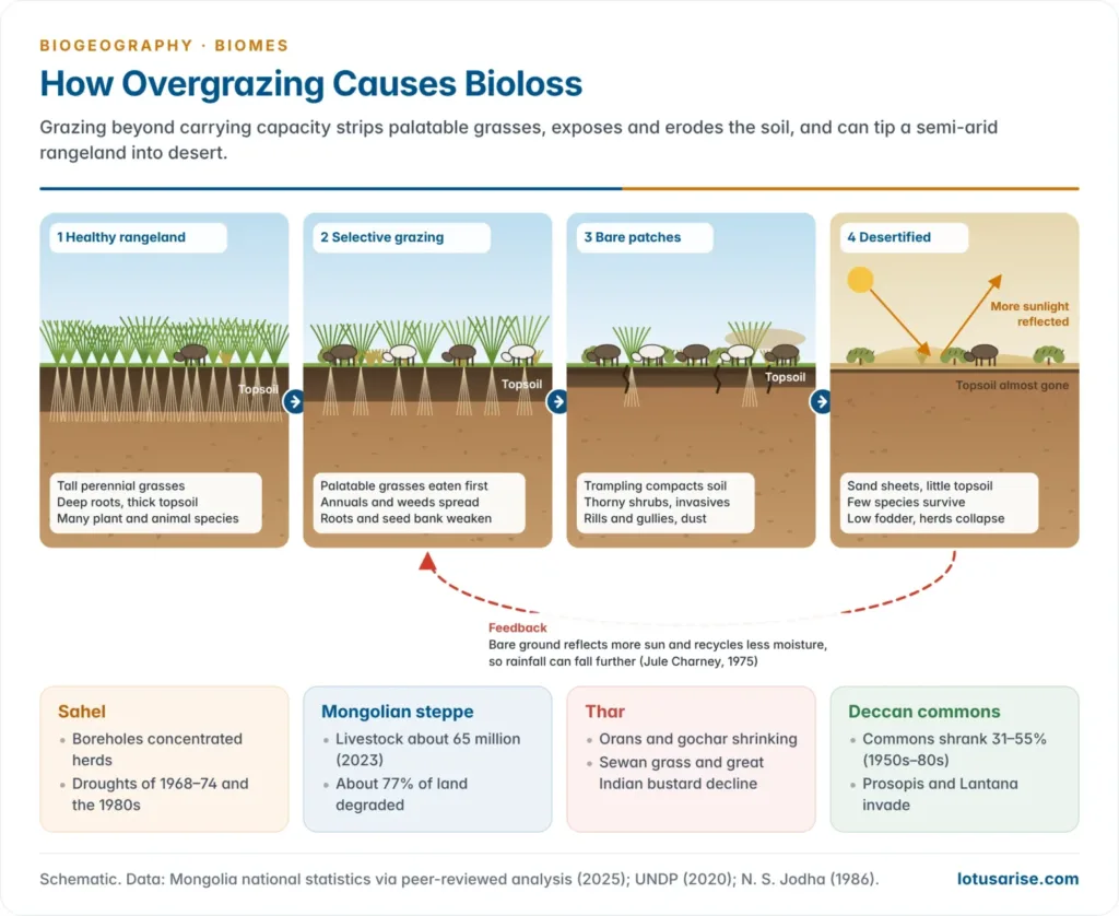
- Overgrazing is grazing beyond the carrying capacity of a pasture, so plants are eaten faster than they regrow. Its result is bioloss: loss of plant biomass, species, soil and dependent animals.
- Rangelands cover about 54% of the land and support some two billion people; UNCCD (2024) estimates that up to half are degraded. 2026 is the UN International Year of Rangelands and Pastoralists.
The degradation chain
- Selective grazing removes palatable perennial grasses first; unpalatable annuals, thorny shrubs and invasives replace them.
- Trampling compacts the soil; bare ground spreads.
- Bare soil loses organic matter and seed bank to wind and water erosion.
- Higher albedo and less moisture recycling can reduce rainfall, a Sahel feedback proposed by Jule Charney (1975).
- The end state is desertification: fewer plants, insects, birds and mammals, and less fodder for the herds themselves.
Bioloss in the world’s rangelands
- The Sahel:
- Herds grew in the wet 1950s–60s around new boreholes, stripping pasture in rings around each well (piospheres); the droughts of 1968–74 and the 1980s then killed much of the livestock.
- Partial re-greening since the 1990s followed better rains and farmer-managed natural regeneration in Niger; the African Union’s Great Green Wall (2007) aims to restore a belt across the region.
- The Mongolian steppe:
- After collective herding ended in 1990, livestock rose about 2.5-fold to some 65 million (2023), far above carrying capacity.
- Cashmere goats, which crop grass to the roots, grew to about 38% of the herd.
- About 77% of the country is affected by degradation (UNDP, 2020); the dzud (severe winter) of 2023–24 killed about 7 million animals. Mongolia hosted UNCCD COP17 in August 2026.
- The Thar:
- Western Rajasthan carries one of the densest livestock populations of any hot desert; vegetation degradation affects about 9% of India’s area (ISRO atlas, 2018–19).
- Sacred groves (orans) and grazing lands (gochar) have shrunk; sewan grass has thinned and the great Indian bustard has declined.
- The Deccan commons:
- Narpat S. Jodha (1986) found that commons in some 80 dry-region villages had shrunk by 31–55% between 1950–52 and 1982–84, though the poor drew most of their grazing from them.
- Herds crowded onto what remained, the “tragedy of the commons” of Garrett Hardin (1968), worsened by the collapse of village grazing rules; Prosopis and Lantana now overrun many commons.
- Elsewhere: rabbits and sheep in Australia, and South Africa’s Themeda veld, where red grass gave way to unpalatable xerophytes. Many savannas are partly the product of fire and grazing.
7. Land use, land cover and forage in semi-arid regions
- Forage is grass, browse and crop residue eaten by herbivores: its quantity is biomass per hectare, its quality protein, digestibility and minerals.
- In semi-arid regions (about 250–750 mm of rain) rainfall sets the ceiling, but land use, land cover and soil decide how much is realised and how nutritious it is.
Land use and land cover
- Cropland expansion onto the best rangeland pushes herds onto poorer, shrinking commons; the Indira Gandhi Canal command turned Thar pastures into fields.
- Woody encroachment under heavy grazing and fire suppression replaces grass with thorn bush, as in Namibia and the Banni.
- Ploughing grassland before a drought caused the Dust Bowl of the 1930s on the Great Plains.
- Rotational grazing, enclosures and agroforestry such as Rajasthan’s khejri parklands sustain forage.
Soil types
- Sandy soils hold little water or nutrient, so yields are low; tussock grasses such as sewan suit them in the Thar.
- Clay soils such as Deccan Vertisols grow more productive grass but are taken for crops. Saline soils of the Rann of Kachchh carry less palatable salt-tolerant grasses.
- Fertile versus leached soils: South Africa’s sweetveld on fertile, drier soils stays palatable all year; sourveld on leached, wetter soils does not. Serengeti wildebeest seek short grass on mineral-rich volcanic soils in the wet season.
- India’s grass covers (R. M. Dabadghao and K. A. Shankarnarayan, 1973) follow climate and soil: Sehima–Dichanthium in the peninsula, Dichanthium–Cenchrus–Lasiurus in the arid north-west.
| Region | Dominant land use | Soil | Forage outcome |
|---|---|---|---|
| Sahel | Pastoralism, rainfed millet | Sandy, low in nutrients | Annual grasses; quantity swings with rain |
| Mongolian steppe | Mobile herding | Chestnut soils (Kastanozems) | Good quality, falling quantity under goats |
| Thar | Herding, canal and rainfed farming | Sandy desert soils | Sewan and dhaman grass; commons shrinking |
| Deccan plateau | Cropping, village commons | Vertisols and red soils | Productive grass lost to fields and weeds |
| Great Plains | Ranching, wheat | Mollisols | High quality; ploughing caused the Dust Bowl |
8. Human-induced extinction
- Extinction is natural, but man has accelerated it by hunting (Paul S. Martin’s (1967) “Pleistocene overkill” of megafauna), by habitat removal and pollution faster than species can adapt, and by introduced predators and diseases.
- Mammal extinctions rose sharply through the nineteenth and twentieth centuries, the backdrop to modern wildlife conservation.
Habitat Fragmentation
- Habitat fragmentation is the division of large, contiguous habitat into smaller, isolated patches by urban development, agriculture, logging and infrastructure. It changes landscape structure and so affects species distribution, genetic diversity and ecosystem processes.
- About 70% of the world’s forest lies within 1 km of an edge; long-term experiments show fragmentation cutting species richness by 13–75% (Nick Haddad and colleagues, 2015).
Causes of habitat fragmentation
| Cause | Mechanism |
|---|---|
| Urban development | Cities and towns turn natural habitat into residential, commercial and industrial land, leaving small patches amid infrastructure |
| Agriculture | Forests, grasslands and wetlands become fields; monocultures cut habitat variety |
| Infrastructure | Roads, highways, railways, canals and pipelines dissect habitat and block movement |
| Logging and mining | Large clearings leave broken landscapes that disrupt ecological processes |
How a landscape fragments
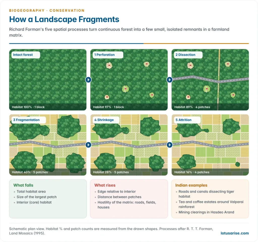
- Richard T. T. Forman (1995) described five overlapping processes of land transformation:
- Perforation: clearings and houses make holes in continuous habitat.
- Dissection: roads, canals or power lines cut it into parts.
- Fragmentation: clearings join and the habitat breaks into separate patches.
- Shrinkage: the patches get smaller.
- Attrition: the smallest patches disappear.
- As it advances, habitat falls, edge grows relative to interior, patches drift apart and the matrix turns hostile.
Ecological consequences of fragmentation
| Consequence | Explanation |
|---|---|
| Loss of habitat area | Less suitable habitat; small patches hold fewer individuals and seldom sustain viable populations |
| Edge effects | More edge relative to interior; light, temperature and wind change, favouring generalists over specialists (Carlos Murcia, 1995) |
| Isolation of populations | Dispersal and mate-finding fail; genetic diversity falls and extinction risk rises. In Brazil’s Atlantic Forest, bird richness depends on fragment size and connectivity (Alexandre Martensen et al., 2008) |
| Disrupted processes | Pollination, seed dispersal and predator–prey links break; pollinator movement falls (Adam Hadley and Matthew Betts, 2012) |
| Vulnerability to invasion | Disturbed fragments are easily invaded by non-native species (Kimberly With, 2004) |
Edge effects
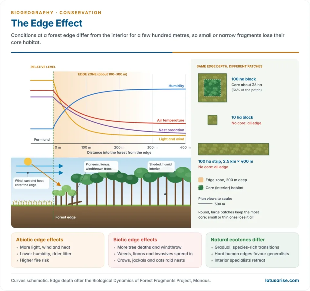
- An edge effect is the change in conditions and species at the boundary between a patch and the surrounding land.
- Abiotic: more light, wind and heat, lower humidity, drier litter and more fire.
- Biotic: more tree deaths; pioneers, lianas and weeds take over; nest predators such as crows and jackals enter from the matrix; interior specialists retreat.
- Depth of influence: near Manaus, the Biological Dynamics of Forest Fragments Project found most edge effects reaching 100–300 m into the forest, and fire further.
- With a 200 m edge, a 100 ha square fragment keeps about 36 ha of core; a 10 ha fragment keeps none. Small or elongated patches are almost all edge, a lesson of island biogeography for reserve design.
- Natural ecotones are rich in species, a positive edge effect among plant communities; the hard human-made edge mostly favours generalists and invaders.
Isolation, metapopulations and extinction debt
- A metapopulation, a concept of Richard Levins (1969), is a “population of populations” in separate patches linked by occasional dispersal.
- Local populations wink out and patches are recolonised from neighbours; the species survives if colonisation keeps pace with extinction.
- Ilkka Hanski demonstrated it with the Glanville fritillary butterfly on some 4,000 meadows of Finland’s Åland Islands.
- Source–sink dynamics (H. Ronald Pulliam, 1988): good patches (sources) export surplus young to poor patches (sinks).
- Fragmentation breaks the network: with patches too few, small or far apart, recolonisation fails and the metapopulation collapses though habitat remains.
- Extinction debt: species linger in fragments for decades before dying out. Small populations also suffer inbreeding and chance events, the extinction vortex of Michael Gilpin and Michael Soulé (1986).
Impacts on species
| Impact | Explanation |
|---|---|
| Reduced population size | Small patches hold few individuals, exposed to demographic swings, environmental change and chance events |
| Reduced genetic diversity | Little gene flow causes inbreeding and lowers adaptive potential |
| Altered species interactions | Competition, predator–prey dynamics and symbiosis shift; changes in predators can raise herbivore pressure and alter plant communities (Lenore Fahrig, 2003) |
- Florida panther (Puma concolor coryi): isolation left only 20–30 animals by the early 1990s, with kinked tails, heart defects and poor sperm, a textbook case of inbreeding depression.
- Eight female Texas pumas released in 1995 brought a genetic rescue (Warren Johnson et al., 2010); numbers rose to an estimated 120–230 adults.
Mitigation strategies
| Strategy | Explanation |
|---|---|
| Habitat corridors | Link fragments for movement, gene flow and recolonisation |
| Protected areas | Larger, connected reserves conserve contiguous habitat |
| Land-use planning | Urban green space, retained habitat and sustainable farming minimise fragmentation |
| Restoration ecology | Reforestation, wetland restoration and corridor creation rebuild connectivity |
- India: corridors in the Western Ghats have improved connectivity for tigers and elephants.
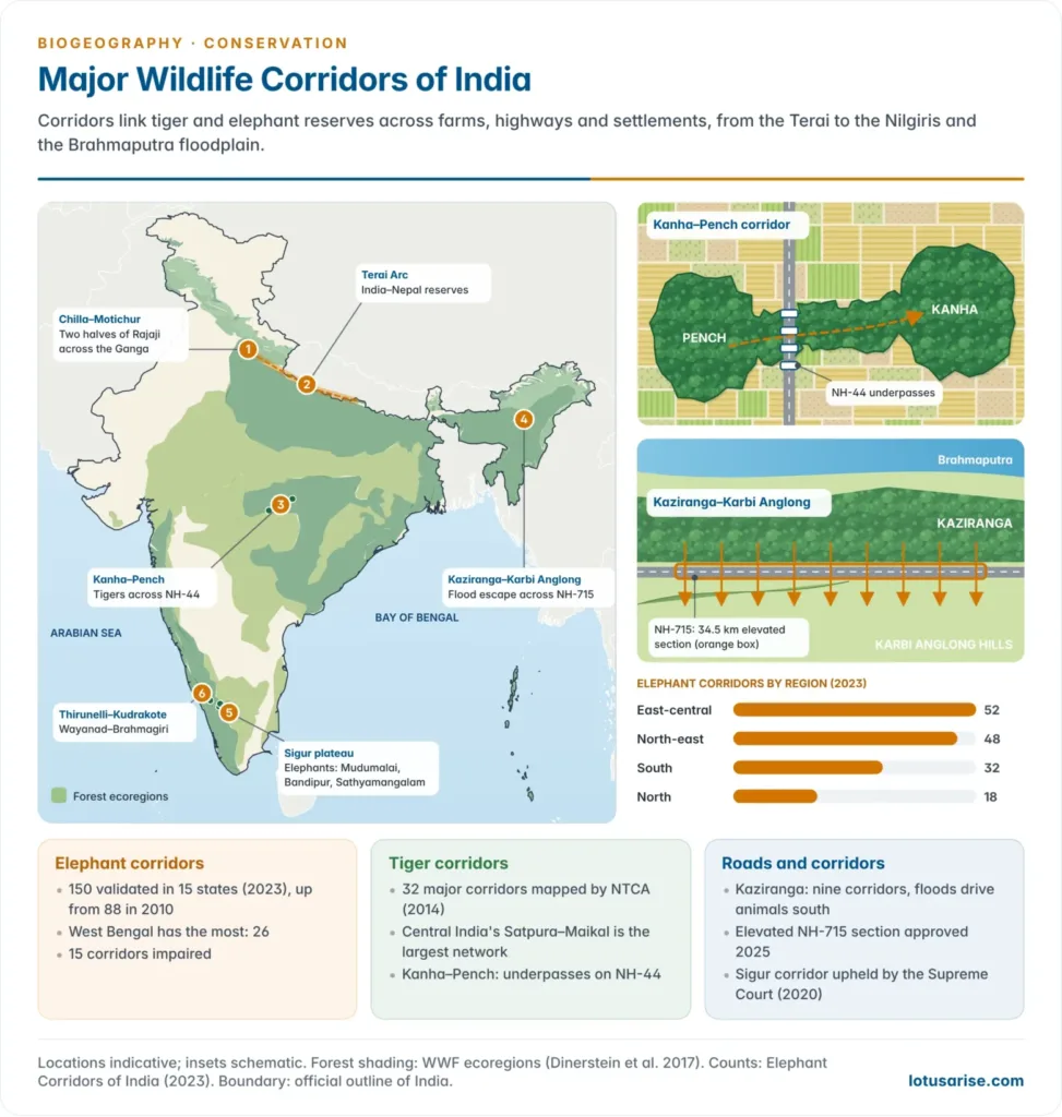
- The Supreme Court in October 2020 upheld the Sigur plateau elephant corridor in the Nilgiris, linking Mudumalai, Bandipur and Sathyamangalam.
- The Thirunelli–Kudrakote corridor in Wayanad was secured by voluntary relocation of families.
Landscape Connectivity
- Landscape connectivity is “the degree to which the landscape facilitates or impedes movement among resource patches” (Philip Taylor and colleagues, 1993). It governs survival, reproduction, biodiversity and ecosystem resilience.
- Structural connectivity is the physical arrangement of patches; functional connectivity is the actual movement of a species. A hedgerow links woods for a dormouse, not an elephant.
- Landscape ecology reads land as patches, corridors and a matrix (Richard Forman and Michel Godron, 1986); connectivity is mapped with least-cost paths and circuit theory (Brad McRae, 2008).
Importance of landscape connectivity
| Function | Significance |
|---|---|
| Gene flow and genetic diversity | Movement between populations cuts inbreeding and keeps adaptive capacity |
| Dispersal and colonisation | Wide-ranging and migratory species find territory, resources and mates |
| Resilience to change | Routes to suitable habitat buffer climate change |
| Ecological processes | Pollination, seed dispersal and predator–prey interactions continue |
- Connectivity is central to climate adaptation: species can track shifting ranges only if routes exist, which is why corridors and climate refugia lead the strategies for climate change and biogeography.
Factors influencing landscape connectivity
| Factor | Effect |
|---|---|
| Habitat quality | Good patches supply resources for survival and onward movement |
| Matrix permeability | Natural vegetation lets animals pass; cities and intensive farmland do not |
| Distance between patches | Closer patches are better linked |
| Barriers to movement | Roads, canals, rivers and towns block movement unless crossings exist |
Types of corridors
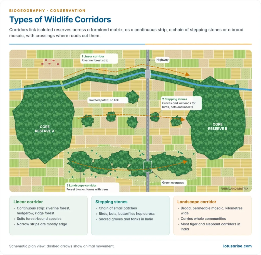
- A wildlife corridor is a strip or chain of habitat linking isolated patches.
- Linear corridors: continuous strips such as riverine forest and hedgerows.
- Stepping stones: small patches (groves, wetlands, sacred groves) that birds, bats and insects hop between.
- Landscape corridors: broad swathes of permeable land carrying whole communities, as most Indian tiger and elephant corridors do.
- Wildlife crossings carry corridors over or under roads and railways; Banff National Park in Canada has more than 40.
- Costs: corridors may spread fire, disease and invasives, and a narrow strip may be all edge.
Enhancing landscape connectivity
| Measure | Explanation |
|---|---|
| Habitat corridors | Natural strips give safe passage for dispersal and migration |
| Protected-area networks | Connected reserves act as refuges and stepping stones |
| Restoration of degraded habitat | Reforestation, wetland repair and invasive removal raise quality and connectivity |
| Land-use planning | Green spaces and riparian vegetation keep the matrix permeable |
| Wildlife crossings | Overpasses and underpasses cut road deaths |
- Global examples: the Yellowstone to Yukon Conservation Initiative along the North American Rockies; the European Green Belt, over 12,500 km along the former Iron Curtain; and the Florida Wildlife Corridor (Act of 2021).
- Policy: Target 3 of the Kunming–Montreal Global Biodiversity Framework (2022) seeks 30% of land and sea in well-connected protected systems by 2030.
Wildlife corridors of India
- Elephant corridors: the “Elephant Corridors of India” (2023) report of Project Elephant (MoEFCC) with the Wildlife Institute of India validated 150 corridors in 15 states, against 88 in 2010.
- East-central India has 52, the north-east 48, the south 32 and the north 18; West Bengal leads with 26. Use rose in 59, and 15 are impaired.
- The first DNA-based count (2025) put wild elephants at about 22,446, with small, fragmented herds in central India.
- Tiger corridors: NTCA’s 2014 report mapped 32 major corridors between tiger reserves. In August 2025 it limited “corridors” for project clearance to these, a move conservationists called too narrow.
- Kanha–Pench: genetic studies confirm tigers moving between the two reserves.
- NH-44 cuts the corridor near Pench; nine underpasses built on court orders are used by tigers, dholes, gaur and other mammals.
- Kaziranga–Karbi Anglong: in monsoon floods rhinos, elephants and deer cross NH-715 to the Karbi Anglong hills through nine animal corridors (Panbari, Haldibari, Kanchanjuri and others).
- The Supreme Court (2019) barred new construction in them; a 2016–17 study counted over 6,000 roadkills, nearly two-thirds in floods.
- A 34.5 km elevated wildlife corridor on NH-715, approved in October 2025, will let animals pass beneath.
- Others: the Chilla–Motichur corridor joining the two halves of Rajaji across the Ganga, and the Terai Arc linking Indian and Nepalese reserves.
Evaluation
- Habitat loss versus fragmentation: Lenore Fahrig (2003, 2017) argued that most harm comes from loss of habitat amount, and that fragmentation per se has weak, often positive effects. Critics reply that edges and isolation clearly harm interior and wide-ranging species; both sides agree that keeping habitat matters most.
- Corridor value depends on the species, and the matrix itself can be made friendlier through agroforestry and wildlife-friendly farming.
- India’s challenge is to keep corridors open amid dense settlement and linear infrastructure; corridor loss pushes elephants into fields and villages.




