

- Irrigation is the artificial supply of water to crops through canals, wells, tube wells, tanks and similar works, drawing on rivers, reservoirs, tanks, ponds or ground water. Rain is the natural supply, and irrigation makes up what it leaves short.
- In 2023-24, India irrigated 82.42 million hectares net, which is 59.3% of net sown area, and 130.55 million hectares gross. The share of net sown area was 17.6% in 1950-51.
Agricultural Infrastructure
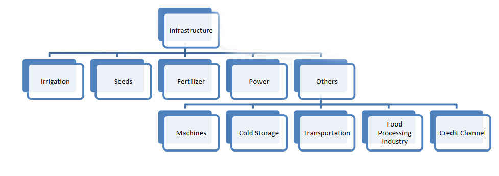
- If farming is the lifeblood of the Indian economy, infrastructure works like its arteries and veins, sustaining the sector and the wider growth that rests on it.
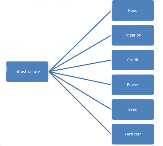
- In agriculture, the term means mainly physical facilities that serve the farmer from sowing to selling: irrigation, road connectivity, electrification, storage and telecommunication.
- Investment in infrastructure lowers the cost per unit of input, raises productivity, creates further income and builds capacity.
- Its spill-over effects include rural development, less hunger and poverty, and better care of natural resources.
Determinants of Agriculture
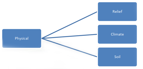
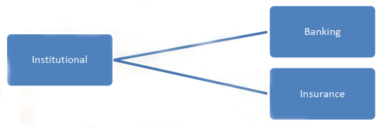
- The determinants of agriculture shape the farming pattern, cropping pattern and productivity of a region. The four charts below set out the groups: physical, infrastructural, institutional and technological.

Irrigation in India
Need for Irrigation
- The purpose of an irrigation system is to keep crops supplied with at least the minimum water they need, to check weeds in grain fields and to prevent soil consolidation.
- Some two-thirds of cropped land needs irrigation. Rain alone cannot carry it, because the monsoon is irregular, undependable, variable, seasonal and patchy.
- Features of the monsoon that make irrigation necessary:
- Uncertain arrival: the south-west monsoon keeps its normal dates in only about one year in five.
- High variability where rain is scarcest: Punjab, Haryana, Rajasthan and western Uttar Pradesh.
- Uneven spread: parts of Meghalaya get over 1,000 cm a year, parts of the Thar under 10 cm.
- Too little rain over most farmland: only about 30% of the cultivated area gets over 100 cm. About 36% gets 75–100 cm, and 34% gets less than 75 cm. Even high-rainfall areas need irrigation to lift productivity further.
- Monsoon gaps: two or more rainless weeks in the wet season can ruin crops that have no back-up water.
- Seasonality: about 75% of rain falls in 3–4 months. The other 8–9 months are dry, when crops badly need water. The dry season lasts about 5 months in Keralam (Kerala) and 9 or more in the north-west.
- Torrential rain: soil has little time to absorb it, and water runs quickly off hill slopes and is lost.
- Other reasons:
- Ending monoculture: assured water lets farmers grow more than one crop.
- Rural change: irrigation supports the socio-economic transformation of rural India, by making farming viable.
- Thirsty crops: rice, sugarcane, jute, cotton and chillies need extra water even in wet areas.
- The Green Revolution package: high-yielding seeds and heavy fertilizer doses need assured water.
- Soil texture: sandy and loamy soils hold water less well than alluvial clays and black soil.
- Population: more mouths mean more intensive farming, and so more irrigation with other inputs.
- Plant physiology: water carries essential materials through the plant.
- Salt: irrigation can leach or dilute salts in the soil.
- Output: productivity, cropping intensity and gross cropped area all depend on a wider network.
- Yield gain: irrigated crops yield an estimated 50–100% more than unirrigated crops under similar conditions.
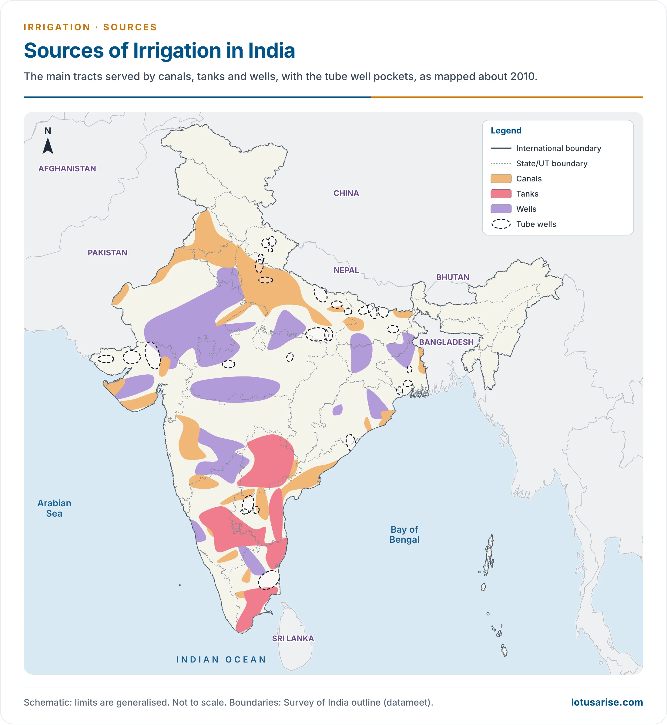
- This 2010 map shows tube wells only as scattered pockets. The figures below give their present weight.
The Benefits and Ill Effects of Irrigation
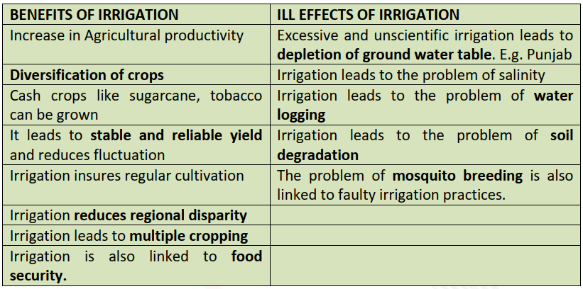
- Output and security: productivity rises, yields become stable and reliable, and cultivation becomes regular. About 60% of foodgrain output was estimated to come from irrigated land.
- Choice of crops: water allows diversification, cash crops such as sugarcane and tobacco, and multiple cropping.
- Wider gains: less regional disparity and better food security.
- Costs: excessive, unscientific irrigation lowers the water table, as in Punjab, and brings salinity, waterlogging, soil degradation and mosquito breeding.
Geographical Factors Favouring Irrigation
- Northern plains favour it:
- The gentle slope lets canals carry water to distant fields.
- Soft, friable soil makes canals and wells easy to dig.
- Deep clay in the sub-soil stores rain that percolates through porous alluvium. This gives plentiful ground water for wells and tube wells.
- Perennial rivers supply water all year, though flow changes with the season.
- The Peninsular plateau makes it harder:
- Hard rock makes canals and wells difficult to dig, which is why tank irrigation is common here.
- Uneven surface stops canals from carrying water far.
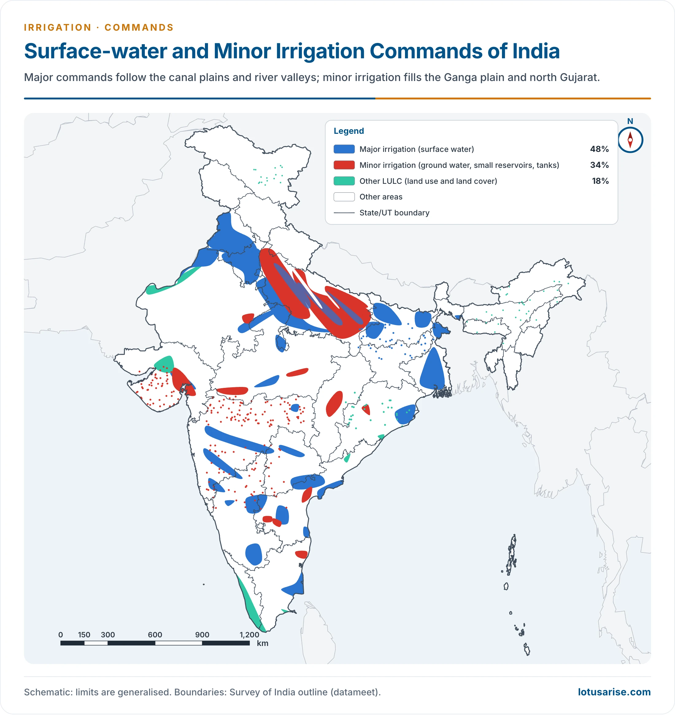
- This map shows surface-water (major) and minor irrigation commands. The percentages in its key describe this map only. The source shares of net irrigated area are given below.
Development of Irrigation
- At Independence, India stood at the second of the stages of economic growth set out by Walt Whitman Rostow, with most people dependent on primary farming.
- From the First Five Year Plan, planners treated agricultural development as the first requirement for growth and regional planning.
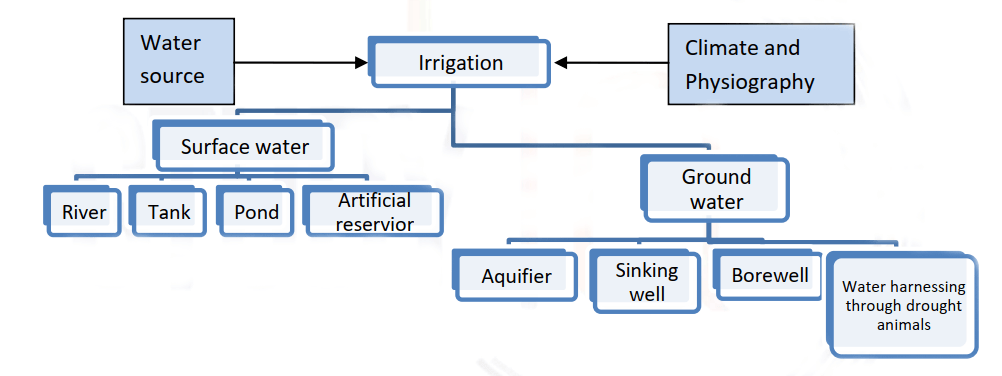
- In this chart, surface water reaches fields through canals and river links, and ground water depends on electricity for lifting through wells and tube wells. “Drought animals” in its last box means draught animals.
- Water supply, climate and terrain decide the irrigation practice of an area.
- Three requirements of any scheme:
- A source of water.
- A distribution channel.
- Field application.
Historical Developments in Irrigation
- Irrigation goes back to ancient times. Hindu monarchs, Mughal emperors and British rulers all carried out notable engineering works.
- Undivided India had some of the world’s best irrigation systems. Partition sent much of the canal-irrigated land of the Satluj and Indus to Pakistan.
- After Independence, Plan-based programmes began, to secure balanced regional development and rural development.
- Ultimate irrigation potential was first put at about 113 million hectares. It now stands at about 139 million hectares, after upward revision of minor schemes.
- Potential outran use: by the Tenth Plan, 102.77 million hectares had been created and 87.23 million hectares used. The gap of 15.54 million hectares lay mostly in major and medium projects.
- Why major and medium works lag: long gestation, heavy cost, inter-State water disputes, land acquisition and resettlement of oustees.
- Why potential goes unused: poor command area development, shifts to thirsty crops and missing field channels.
- Falling investment: irrigation’s share of State plan outlay dropped from 23.2% in the First Plan to 6.0% in the Tenth.
- Water-use efficiency: canals reach only about 38–40%, against an ideal of 60%. Ground water schemes reach about 60%.
- Causes: silted canals, weeds, broken regulators, field-to-field flooding in old deltas and very low water rates.
- Remedies: a package of modernisation, conjunctive use, tamper-proof outlets, and sprinkler and drip systems.
Types of Irrigation Projects
- Projects are classed by culturable command area (CCA):

- Major and medium projects draw mainly on surface water. Minor projects use both surface and ground water.
Sources of Irrigation
- The choice of source depends on topography, soil, rainfall, whether surface or ground water is at hand, whether rivers are perennial, and what the crop needs.
- The main types are wells and tube wells, canals, tanks, traditional water harvesting and micro-irrigation.
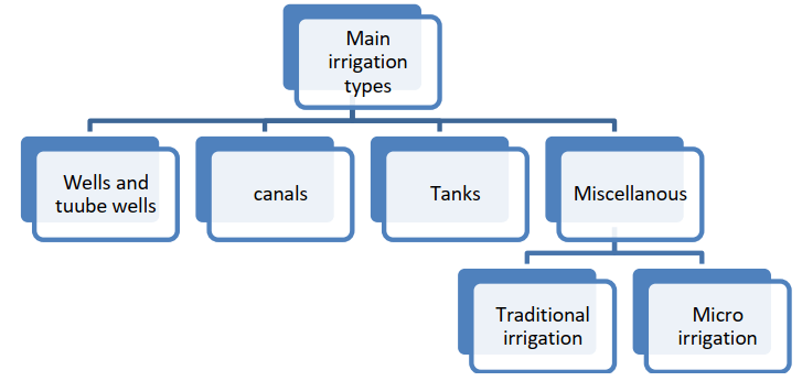
- Traditional irrigation covers long-standing rural practices, known by names such as johars, baolis, hundu, suragam, kuhls, springs and dongs.
- Micro-irrigation is a water-saving technology promoted in India and abroad, which raises cropping and irrigation intensity by placing water exactly where the crop needs it.
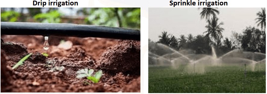
- Drip irrigation: emitters release water near the root, on or under the soil, at a low rate of 2–20 litres an hour. Frequent application keeps soil moisture at the best level.
- Sprinkler irrigation: water under pressure passes through small nozzles and falls rather like rain. It suits uneven land and shallow soils.
- Coverage on 31 March 2024: 167.36 lakh hectares, split into 76.89 lakh under drip and 90.47 lakh under sprinkler. Karnataka, Rajasthan, Maharashtra and Andhra Pradesh lead.
- Other field methods:
- Furrow: a surface method. Water runs down trenches between crop rows and seeps down and sideways, refilling the soil store. Each furrow can be controlled on its own.
- Surge: a variant of furrow irrigation in which water is pulsed on and off at set times. Wetting and drying reduce infiltration, so water advances faster and more evenly.
- Ditch: a traditional method. Seedlings stand in rows, with channels between them, and siphon tubes lift water from the main ditch.
- Sub-irrigation or seepage: water reaches the root zone from below and rises through the soil. It suits high water tables and greenhouses.
- Border strip and basin: two further surface methods. Flow by gravity wets the field, and heavy use is called flood irrigation.
- Localised irrigation: low-pressure pipes deliver small discharges beside each plant, and include drip, micro-sprinkler and bubbler systems.
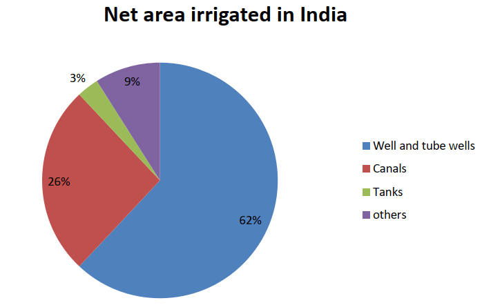
- This pie shows 2009-10. The table sets it beside 2023-24.
| Source | Share, 1950-51 | Share, 2009-10 | Area, 2023-24 (million ha) | Share, 2023-24 |
|---|---|---|---|---|
| Tube wells | 0.55% in 1960-61 | With wells | 39.41 | 48% |
| Other wells | 28.67% | 62% (all wells) | 12.47 | 15% |
| Canals | 39.78% | 26% | 17.42 | 21% |
| Tanks | 17.33% | 3% | 3.14 | 4% |
| Other sources | About 14% | 9% | 9.99 | 12% |
| Net irrigated area | 100% | 63.25 million ha | 82.42 | 100% |
- Irrigation intensity (gross over net irrigated area) stood at 158.4% in 2023-24.
- Another sense of the term, the net irrigated share of net sown area, gives the regional picture:
- Highest, above 60%: Punjab, Haryana, the Ganga–Yamuna Doab, western Bihar, Birbhum, Lakhimpur, the Godavari–Krishna deltas and Chengalpattu.
- Middle, 30–60%: large parts of the northern and east coastal plains.
- Low, 15–30%: parts of the Brahmaputra plain, Chambal valley and Peninsular plateau.
- Least: western Rajasthan, the central plateau, the Maharashtra and Keralam coasts, Manipur, Mizoram and Tripura.
- Near total: Ladakh and Lahaul–Spiti cannot raise a crop without water.
- By crop (2020-21): sugarcane 96.7%, wheat 95.6%, rice 66.7%, all foodgrains 59.0% and oilseeds 33.7%.
- Three components of any system:
- Storage.
- Conveyance.
- Field application.
- An efficient irrigation method, meaning the way water is carried from source to crop, has these traits:
- Uniform distribution of water.
- Minimum transport loss and minimum loss of soil.
- Maximum water stored in the root zone.
- No harm to crop growth.
- Economic soundness and adaptability.
Irrigation Types
Tank Irrigation
- A tank is water storage made by building a small bund of earth or stone across a stream. The water held behind it serves irrigation and other uses.
- Most are small, the work of single farmers or small groups. Some are part dugout and part bund.
- Falling share: tanks gave 14% of irrigated area in 1960-61 and about 3% around 2010, because wells and tube wells spread and tank irrigation itself declined. In 2023-24 they stood at 3.14 million hectares, or 4%.
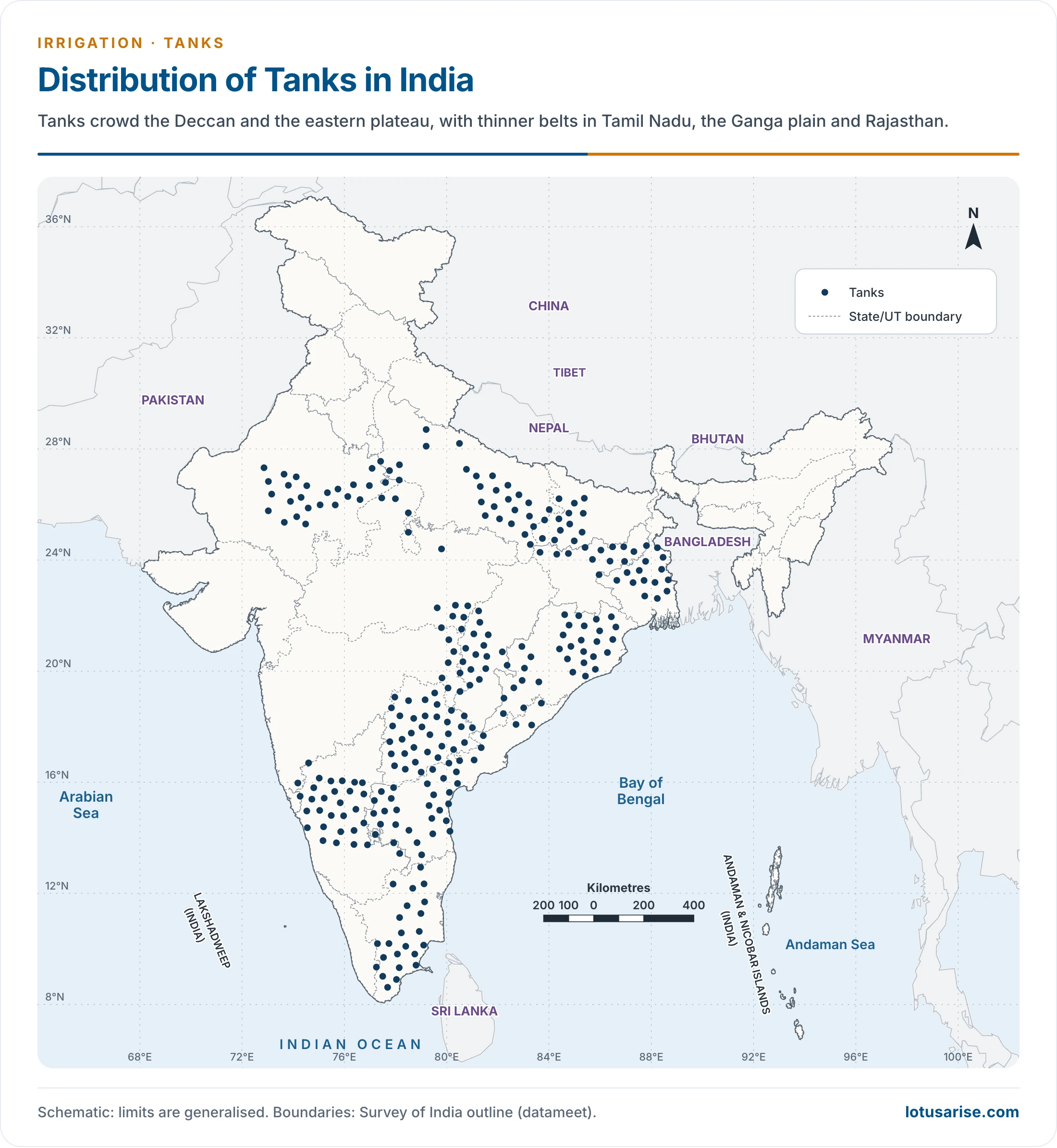
- Geographical distribution:
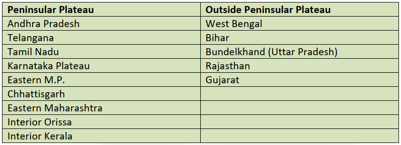
- Andhra Pradesh, Telangana and Tamil Nadu lead.
- Andhra Pradesh and Telangana together hold about 28% of tank-irrigated area, and Tamil Nadu about 23%.
- The Godavari and its tributaries drain a dense tank country. Nellore and Warangal stand out among districts.
- Why tanks suit peninsular India:
- Undulating relief and hard rock make canals and wells difficult.
- Hard rock limits percolation, so ground water is scarce.
- Most rivers run dry in summer, so they cannot feed canals all year.
- Streams turn torrential in the rains, and bunds and tanks hold water that would otherwise run off to the sea.
- Scattered settlement and fields favour a local source.
- Merits and demerits:
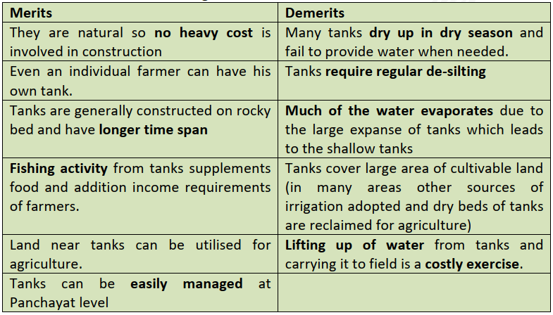
Wells
- A well is a hole dug to reach subsoil water.
- A common well goes down about 3–5 m, and deeper ones reach about 15 m or more.
- Lifting methods: Persian wheel, reht, charas or mot, and dhingli.
- Geographical distribution:
- Wells of all kinds give about 63% of net irrigated area (51.87 of 82.42 million hectares in 2023-24). Area under them rose about six-fold from 1950-51 to 2009-10.
- Areas with enough sweet ground water:
- The Northern Plains.
- The deltas of the Mahanadi, Godavari, Krishna and Cauvery.
- Parts of the Narmada and Tapi valleys.
- Weathered tracts of the Deccan Trap.
- Crystalline and sedimentary zones of the Peninsula.
- Unsuitable areas:
- Most of peninsular India, for its uneven surface, rocky structure and shortage of ground water.
- The dry tract of Rajasthan and adjoining Punjab, Haryana, Gujarat and parts of Uttar Pradesh, where brackish water is unfit for irrigation or drinking.
- State shares of well-irrigated area (2009-10): Uttar Pradesh about 28% (an older count gives 23%), Rajasthan 10%, Punjab 8%, Madhya Pradesh 7.9%, Gujarat 7.3% and Bihar 6.2%.
- Wells matter most in Gujarat, Punjab, Uttar Pradesh, Rajasthan, Maharashtra, Madhya Pradesh, West Bengal and Bihar, where they carry well over half of net irrigated area.
Tube Wells
- A tube well goes deeper, generally past 15 m, and a pump set driven by an electric motor or diesel engine lifts the water.
- Favourable conditions:
- Enough ground water: a tube well irrigates about 2 hectares a day, against 0.2 hectare for an ordinary well.
- A high water table: pumping is cheapest near 15 m, and becomes uneconomic once water falls below about 50 m.
- Cheap, regular electricity or diesel, so water can be drawn when needed.
- Fertile soil nearby, so extra output repays the cost of building and running it.
- India’s first tube well dates from 1930, in Uttar Pradesh, and only 2,500 existed by 1951.
- Wells multiplied after the Green Revolution in Punjab, Haryana and western Uttar Pradesh.
- Water application efficiency is about 60% in well and tube well irrigation.
- The tube well’s rise is called the ground water revolution, for the push-button control it gives the farmer.
- It also carries the risk of depletion. Nationally, the stage of ground water extraction stood at 60.63% in 2025, and far higher in the north-west.
- Merits and demerits of well and tube well irrigation:
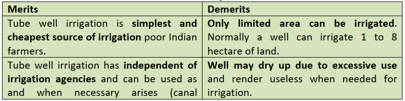
- The merit cut off on this chart reads in full: canals are controlled by other agencies, while a well can be used whenever needed.
| Merits | Demerits |
|---|---|
| Simple and cheap, within reach of the poor farmer | Limited area, normally 1–8 hectares a well |
| Independent of irrigation agencies, used at will | Can dry up under excessive use |
| Avoids the canal problem of reh (salt crust) | Water level falls in drought, just when most needed |
| Can be dug anywhere, unlike a canal that ends at its tail | Heavy pumping dries out neighbouring land |
| Nitrate, chloride and sulphate in the water can add fertility | Impossible where ground water is brackish |
| No regular canal charge |

- This ranking predates the Sixth Minor Irrigation Census (2017-18). That census counted 23.14 million minor schemes, 94.8% on ground water. Uttar Pradesh leads in all minor schemes and in shallow tube wells, Karnataka in medium and Punjab in deep tube wells, and Maharashtra in dug wells.
Canals
- Canals were the leading source until the 1960s, and gave way to wells and tube wells in the 1970s. Their share fell from about 40% in 1950-51 to 21% in 2023-24.
- They suit low relief, deep fertile soil, a perennial source and a wide command, so they cluster on the northern plain. In the south they are mainly coastal and deltaic.
- Two types:
- Inundation canals have no regulating work at the head. They run only when a river is in flood, and most have been converted.
- Perennial canals take off from a barrage on a perennial river. Most Indian canals are of this kind.
- The named systems, State by State, are set out under important canals in India.
| Merits | Demerits |
|---|---|
| Perennial supply protects crops against drought | Seepage causes waterlogging along the route |
| Silt can add to soil fertility | Rising water table draws salts to the surface: reh in Punjab, Haryana and Uttar Pradesh, and about 36,000 hectares in the Nira valley |
| Often part of multipurpose projects | Marshy margins breed mosquitoes |
| High first cost, but cheap in the long run | Overflow floods nearby land in the rains; suited only to plains |
Schemes for Irrigation
- Accelerated Irrigation Benefit Programme (AIBP), from 1996-97, helps States finish incomplete projects. Command Area Development has been merged with it to narrow the gap between potential and use.
- Pradhan Mantri Krishi Sinchayee Yojana (PMKSY), launched on 1 July 2015, aims at wider assured irrigation and better on-farm water use. It was continued for 2021–26 with an outlay of Rs 93,068.56 crore.
- AIBP: quick completion of major and medium projects.
- Har Khet Ko Pani: new sources through minor irrigation, and repair and restoration of water bodies.
- Watershed Development: rainfed and degraded lands.
- Per Drop More Crop: drip and sprinkler. It moved under PM-RKVY from 2022-23, and has covered 110.92 lakh hectares since inception.
- Modernisation of Command Area Development and Water Management (M-CADWM): a sub-scheme approved in 2025-26, delivering canal water through pressurised pipes and micro-irrigation.
- Interlinking of rivers would raise ultimate potential from about 140 to 175 million hectares on the official count.
Previous Year Questions
2020Canal irrigation has led to monocropping in India. Explain with suitable examples.1996Discuss the importance of irrigation in Indian Agriculture and describe the methods of irrigation practiced in either the Ganga Valley or the Karnataka-Maharashtra region.1990Discuss the spatial variation in the developmental levels of canal irrigation in India in relation to their utilization.





I love it geography