- Population geography is the branch of Human Geography that studies population in a spatial perspective: how its numbers, characteristics and changes vary over space and time, and why.
- The name joins two ideas:
- “Population” is the subject matter: people and their attributes.
- “Geography” is the viewpoint: areal differentiation, location and the relation of people to place.
- It asks three questions of every population fact: where it occurs, why it is distributed that way, and what it means for the places concerned.
Definitions

What the Field Studies
- The study of human occupation of the Earth’s surface: where people live and in what densities.
- The geographic organisation of population, analysed against the physical environment and the cultural environment.
- The two-way relation between population and place:
- Population characteristics are shaped by spatial processes such as diffusion, migration and urbanisation.
- Population in turn reshapes places through settlement, land use and demand for resources.
Classical Definitions
- Glenn Trewartha (1953, 1969) gave the foundational definition.
- Population geography is concerned with regional differences in the Earth’s covering of people.
- Since areal differentiation is the core of geography, it is also the core of population geography.
- Population is the point of reference from which all other elements of geography are observed and from which they take meaning.
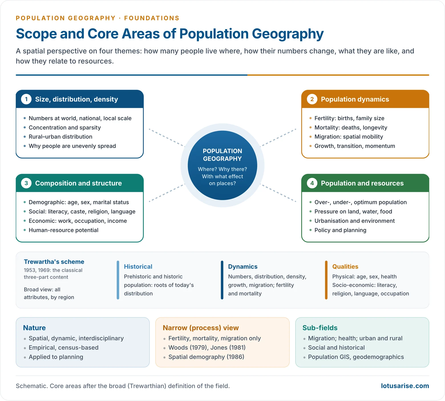
- He widened the field from numbers to all population characteristics, and divided its content into three parts:
- Historical: population in prehistoric and historic times, which explains the long evolution of today’s distribution.
- Dynamics: numbers, distribution, density, growth and migration, through fertility and mortality.
- Qualities: physical attributes (age, sex, health) and socio-economic attributes (literacy, religion, language, occupation, marital status), studied for their regional variation.
- A Geography of Population: World Patterns (1969) applied this scheme to the world.
- John I. Clarke (1965, 1972) stressed the link between population and place.
- Population geography shows how spatial variations in the distribution, composition, migration and growth of population are related to spatial variations in the nature of places.
- Its aim is to explain the relationship between population and environment, not just to describe patterns.
- Wilbur Zelinsky (1966) stressed dynamic interaction.
- The field studies how the geographic character of places is formed by population phenomena, and how these phenomena in turn respond to place, through both space and time.
- He suggested that its working scope could be set by what censuses and registration systems record. This shows the field’s empirical, data-based foundation.
- Jacqueline Beaujeu-Garnier (Géographie de la population, 1956–58; English edition 1966) placed population at the centre of human geography.
- The task is to describe population facts in their present setting and to examine their causes, peculiarities and consequences.
- Daniel Noin (Géographie de la population, 1979) organised the field around three tasks:
- describing population characteristics;
- mapping distribution patterns;
- analysing the components of growth.
Recent Definitions
- Adrian J. Bailey (2005) defined the field as the study of the geographic organisation of population and why it matters to society. It covers:
- the spatial distribution, size and composition of populations;
- how these are regulated by the demographic processes of fertility, mortality and migration;
- their implications for economic development, ecological change and social issues.
- Holly R. Barcus and Keith Halfacree (2018) speak of “population geographies” in the plural.
- Births, deaths and moves are studied within everyday lives and life courses, not as isolated rates.
| Thinker | Year | Key emphasis |
|---|---|---|
| Glenn Trewartha | 1953, 1969 | Regional differences in population; historical, dynamic and qualitative content |
| John I. Clarke | 1965 | Spatial variations in population related to the nature of places |
| Wilbur Zelinsky | 1966 | Two-way interaction of population and place through space and time |
| J. Beaujeu-Garnier | 1956–58 | Population facts, their causes and consequences |
| Adrian J. Bailey | 2005 | Geographic organisation of population and why it matters |
| Barcus and Halfacree | 2018 | Plural population geographies, lives across space |
Nature and Scope
Nature of the Discipline
- Spatial: it explains patterns and regional differences at every scale, from the world to the village.
- Dynamic: population changes continually through births, deaths and moves.
- Interdisciplinary: it borrows from demography, economics, sociology, anthropology and public health.
- Empirical and quantitative: it rests on census and survey data, maps and statistics.
- Applied: it feeds planning and policy for health services, housing, schools, migration and population policy.
- Multi-scalar: the same process looks different at each scale.
- Macro: world and national patterns, such as the north–south contrast in growth.
- Meso: regional and district patterns, such as the north–south fertility divide in India.
- Micro: households and individual life courses, such as a migrant’s decision to move or a couple’s choice of family size.
Significance
- People are both producers and consumers of resources. Their numbers and qualities decide the human-resource potential of a region.
- Every other geographical pattern, from land use to transport and trade, has a population base.
- Planning needs spatial population data:
- the location of schools, hospitals and ration shops;
- the delimitation of constituencies;
- the targeting of high-fertility or high-mortality districts.
- Current problems are population problems at root: ageing in Japan and Europe, rapid growth in Sub-Saharan Africa, urban crowding, refugee flows, and the uneven demographic dividend across India’s states.
The Debate on Scope
The Identity Problem
- Since it emerged, the field has struggled to fix its boundaries.
- Robert Woods argued in the 1980s that population geographers had spread too widely across demographic, social, economic and cultural themes.
- This over-extension blurred the field’s identity.
- Demography, with a clearer method, held a sharper niche.
Broad and Narrow Definitions
- Broad (Trewarthian) definition:
- Studies spatial variation in every aspect of population: distribution, density, composition and socio-economic traits.
- It is pattern-oriented, holistic and regional. Most general texts follow this scheme.
- Narrow (process-based) definition:
- Advanced by Robert Woods (Population Analysis in Geography, 1979) and Huw R. Jones (A Population Geography, 1981).
- It restricts the field to the three components of change: fertility, mortality and migration.
- It is process-oriented and relies on demographic and statistical methods. It grew out of the quantitative revolution.
- Spatial demography:
- Robert Woods and Philip Rees (1986) proposed the term for work that gives equal weight to demographic variables and their spatial distribution.
- It uses statistical techniques and multiregional models. Demography and geography converge here.
| Basis | Broad definition | Narrow definition |
|---|---|---|
| Scope | All population attributes | Fertility, mortality, migration |
| Orientation | Pattern, region | Process, model |
| Method | Description, mapping | Demographic and statistical analysis |
| Roots | Regional tradition (Trewartha) | Quantitative revolution (Woods, Jones) |
Towards a Synthesis
- The disagreement is not about method but about the main thrust of the field.
- Woods himself held that the essential role of population geography is to give a spatial perspective to population studies.
- James L. Newman and Gordon E. Matzke (1984) called it a relatively open field:
- Core: demographic variables, distribution and trends.
- Extended domains: social traits (language, ethnicity, religion), economic traits (occupation, income), rural–urban residence, and resources, politics and policy.
- This openness is its strength (flexibility) and its weakness (loose boundaries).
- The broad and narrow views are different emphases, not contradictions. Together they capture the full range of work in the field.
Core Areas
1. Size, Distribution and Density
- The most basic theme: total population at world, national and regional levels, and its density.
- It covers concentration and sparsity, rural–urban distribution and regional disparity.
- Example: the Ganga plain carries dense rural populations, while the Thar and the Himalaya are sparse.
- It asks why population is unevenly spread, and how physical, economic and historical factors shape the distribution of population.
2. Population Dynamics
- Change over time through the three components:
- Growth trends (increase, stagnation, decline) and the spatial unfolding of the demographic transition and population momentum.
- Example: Kerala and Tamil Nadu fell below replacement fertility long ago, while Bihar is still well above it (SRS 2024).
3. Composition and Structure
- The qualities of population, which shape human resources and development:
- Demographic: age structure, sex ratio, marital status, family structure.
- Social: literacy and education, caste, ethnicity, religion, language.
- Economic: work participation, occupational structure, income and dependency.
- These demographic attributes reveal human-resource potential, development gaps and social inequality.
4. Population, Resources and Environment
- The population–resource relationship: over-, under- and optimum population, and pressure on land, water and food.
- Population and environment: urbanisation, land-use change, degradation and climate risk.
- Population policy and planning.
- This area marks the move from descriptive to applied, policy-oriented study.
Sub-fields
- Migration studies, the most active sub-field since the 1970s.
- Geographies of fertility, mortality and health, overlapping with medical geography.
- Urban and rural population geography.
- Social and cultural composition: religion, language, caste, ethnicity.
- Historical population geography.
- Population–environment studies, including climate migration.
- Spatial demography, geodemographics and population GIS.
Population Geography and Demography
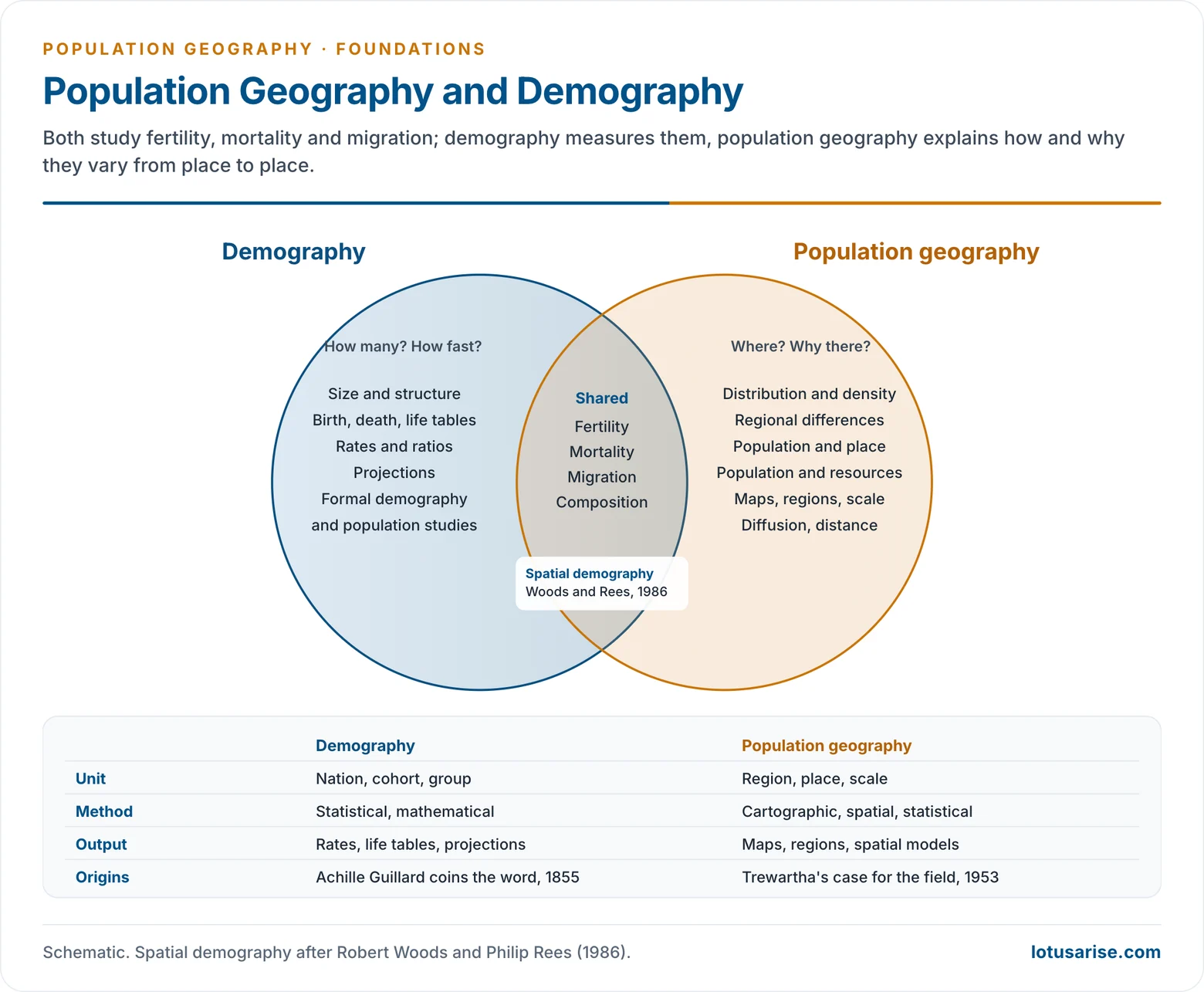
- Demography is the statistical study of the size, structure and change of populations. The word démographie was coined by Achille Guillard (1855).
- Philip M. Hauser and Otis Dudley Duncan (1959) separated formal demography (the measurement of births, deaths and moves) from population studies (the search for their social and economic causes).
- Population geography shares the same data and processes but adds place:
- Demography asks how many and how fast.
- Population geography asks where, why there, and with what effect on places.
- The two are complementary:
- Demography supplies measures and models: rates, life tables, projections.
- Geography supplies spatial analysis: regions, maps, diffusion, distance, environment.
- Spatial demography is the zone where they overlap.
| Basis | Demography | Population geography |
|---|---|---|
| Focus | Size, structure, vital processes | Spatial variation and its causes |
| Unit | Nation, cohort, group | Region, place, scale |
| Method | Statistical, mathematical | Cartographic, spatial, statistical |
| Key question | How many, how fast | Where, why there, with what effect |
| Output | Rates, life tables, projections | Maps, regions, spatial models |
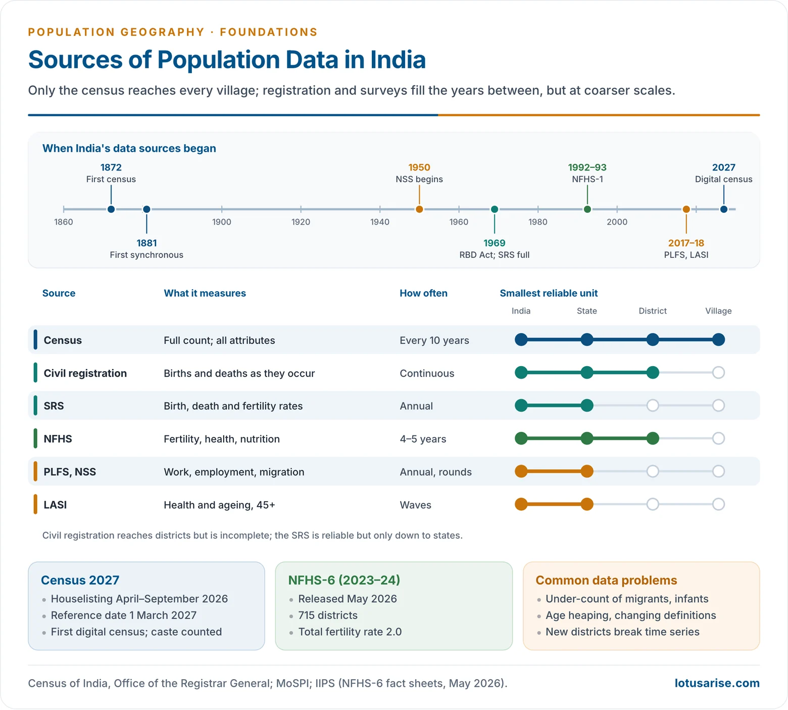
Sources of Population Data
Census
- A census is the total count of a country’s population at one time, with particulars of every individual.
- Its essential features under United Nations principles are individual enumeration, universality within the territory, simultaneity and defined periodicity.
- A de facto census counts people where they are found; a de jure census counts them at their usual residence.
- India:
- The first census was taken in 1872 (not synchronous) and the first synchronous census in 1881. It has been held every ten years since.
- Census 2011 was the 15th census. The 2021 round was postponed.
- Census 2027 is India’s first digital census, with mobile-app enumeration, self-enumeration and caste enumeration.
- Its houselisting phase ran from April to September 2026.
- Population enumeration has a reference date of 1 March 2027 (1 October 2026 for Ladakh and the snow-bound areas). No results are out yet.
- Strengths: full coverage and data down to the village and ward.
- Limits: it is taken only once a decade, it is costly, and it suffers coverage errors.
Vital Registration
- The continuous recording of births, deaths, marriages and divorces as they occur.
- In India this is the Civil Registration System, under the Registration of Births and Deaths Act, 1969. The Act was amended in 2023 for digital registration.
- It is complete in developed countries. In many developing countries it is incomplete, especially for deaths and rural births.
- Vital statistics in planning: birth and death rates feed population projections, the location of maternity and child-health services, immunisation and school-enrolment targets, and the tracking of mortality goals such as the SDG targets on infant and maternal deaths.
Sample Registration System and Sample Surveys
- Sample Registration System (SRS): India’s dual-record system. A resident enumerator records events continuously, and an independent survey cross-checks them.
- It began as a pilot in 1964–65 and on full scale in 1969–70.
- It gives reliable birth, death and fertility rates, but only down to the state level.
- National Family Health Survey (NFHS): run by the International Institute for Population Sciences, Mumbai, since 1992–93.
- NFHS-6 (2023–24), released in May 2026, covers 715 districts and puts India’s total fertility rate at 2.0.
- National Sample Survey rounds on migration and employment, and the Periodic Labour Force Survey (since 2017–18).
- The Longitudinal Ageing Study in India (LASI), first wave 2017–18.
- Worldwide, the Demographic and Health Surveys (DHS) filled data gaps in low-income countries from 1984. The US-funded programme was halted in 2025, a serious loss for population data.
Other Sources
- International compilations: UN World Population Prospects 2024, the World Bank and UN migrant-stock estimates.
- Continuous population registers, as in the Nordic countries.
- New data:
- GIS and satellite-derived gridded population.
- Mobile-phone and administrative records.
- In India, satellite imagery was used to carve out houselisting blocks for Census 2027.
Problems with Population Data
- Coverage errors: under-counting of the homeless, migrants, women and infants. A post-enumeration survey measures the gap.
- Content errors: age heaping on round numbers, misreported literacy or occupation.
- Changing definitions across censuses, for example of urban areas, workers and migrants, which break time series.
- Boundary changes: new states and districts make comparison over time difficult.
- Scale gap: reliable vital rates exist for states, but planning needs districts and blocks.
| Source | What it gives | Frequency | Smallest unit (India) |
|---|---|---|---|
| Census | Full count, all attributes | 10 years | Village, ward |
| Civil registration | Births, deaths | Continuous | District (incomplete) |
| SRS | Birth, death, fertility rates | Annual | State |
| NFHS | Fertility, health, nutrition | 4–5 years | District |
| PLFS, NSS | Work, migration | Annual, rounds | State |