

- The British school of geography is the tradition of geographical thought built in British universities and learned societies from the 1880s, and carried after 1950 into spatial science and the critical geographies.
- Its hallmarks are a strong field and mapping tradition, an emphasis on regions, an applied concern with land, planning and policy, and a long effort to keep physical and human geography together.
- Britain professionalised the subject later than Germany and France. It had no Humboldt, Ritter or Vidal de la Blache, and its geographers long treated geography as exploration and the collection of facts about little-known lands.
- Once established, the school produced some of the discipline’s most influential ideas: Halford John Mackinder’s heartland, Andrew John Herbertson’s natural regions, Patrick Geddes’s regional survey, Laurence Dudley Stamp’s land-use mapping and, later, the models and locational analysis of Richard Chorley and Peter Haggett.
Growth of Geography in Britain

Nineteenth-Century Background
- In 19th-century schools geography was dull and rote-learned: lists of capes, rivers, places and products, taught by untrained teachers.
- In the universities it was not an independent discipline. Geologists taught its physical side, and historians taught it as background to history.
- The Royal Geographical Society (RGS, founded 1830) was mainly concerned with exploration. Much of what its journal printed were reports of expeditions to the unknown parts of the earth.
- The push for the subject was openly imperial. An RGS memorandum of 1879 argued that Britain’s colonies, commerce, emigration, wars and missionaries made sound geographical training “a matter of imperial importance”.
Early Pioneers: Mary Somerville and Francis Galton
- Mary Somerville (1780–1872), a self-taught scholar in touch with the leading scientists of her day, anticipated the scientific character of modern geography.
- Her Physical Geography (1848) covered landforms, oceans, atmosphere, and plant and animal geography. It also treated man as an agent of change on the earth’s surface.
- She revised it through many editions as new data appeared. It made little impact in Britain, where physical geography was claimed by geology, but it influenced George Perkins Marsh in the United States, who drew on her observations of humanity’s destructive use of the earth.
- Francis Galton (1822–1911), better known for his work on heredity, sat on the RGS Council from 1854 to 1893 after travelling in south-west Africa.
- He drew some of the earliest weather maps, published Meteorographica (1863), showed that weather patterns appear when lines of equal pressure are mapped, and identified the anticyclone.
- He prepared the first weather map printed in The Times (1 April 1875) and an isochronic map of travel times from London (1881).
- He called geography “a peculiarly liberalizing pursuit” that links the scattered sciences together.
Institutionalisation: From the RGS to the Universities
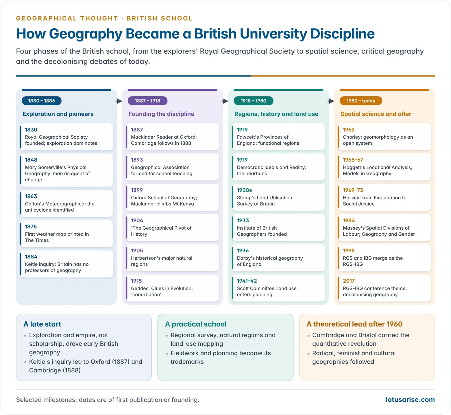
- In 1884 the RGS asked John Scott Keltie to report on geographical education. His report showed that Germany, France and the United States had professors of geography while Britain had none.
- With an RGS grant, Oxford appointed Halford John Mackinder as Reader in Geography in 1887, and Cambridge appointed a lecturer in 1888.
- The Geographical Association (1893) was founded to improve school teaching. The Oxford School of Geography opened in 1899, with Herbertson as Mackinder’s assistant.
- Chairs followed in other universities after the First World War, among them Liverpool (Percy Maude Roxby) and Aberystwyth (Herbert John Fleure). Academic geographers formed the Institute of British Geographers (IBG) in 1933.
- A generation of geographers joined the movement led by Mackinder: Herbertson, George Goudie Chisholm, Hugh Robert Mill, Roxby, Fleure, Charles Bungay Fawcett, Sidney William Wooldridge and Stamp.
Leading British Geographers
Halford John Mackinder (1861–1947)
- Halford John Mackinder is regarded as the founder of the British school. He took degrees in natural science and history at Oxford, and toured the country lecturing on “the new geography” for the university extension movement.
- His paper “On the Scope and Methods of Geography” (1887) set out the programme of the new subject:
- Geography is a bridge between the natural sciences and the humanities. Its core is the interaction of man in society with an environment that varies locally.
- History and geography must never be separated, since every event happens at a particular time in a particular place.
- “No rational political geography can exist which is not built upon and subsequent to physical geography”, a statement that reflects the Darwinian outlook and the influence of Friedrich Ratzel.
- He believed geographers should know the field at first hand. In 1899 he led the first recorded ascent of Mount Kenya.
- In his address “Modern Geography, German and English” (1895) he held that treatment by regions is the sterner test of geographical reasoning, but that regional work rests on systematic study of landforms, climate and life.
- He saw human progress as shaped by two sets of factors: the natural environment and the cultural tradition that communities inherit.
- Britain and the British Seas (1902) is a classic regional study in a global context. It also contained the first comprehensive account of the geomorphology of the British Isles.
- He held many public posts: Principal of University Extension College, Reading (1892–1903); Director of the London School of Economics (1903–08); Member of Parliament (1910–22). He was knighted in 1920.
- He laid the foundation of historical geography in Britain, urging geographers to reconstruct past geographies and show how sequences of change produced the present landscape.
The Heartland Theory
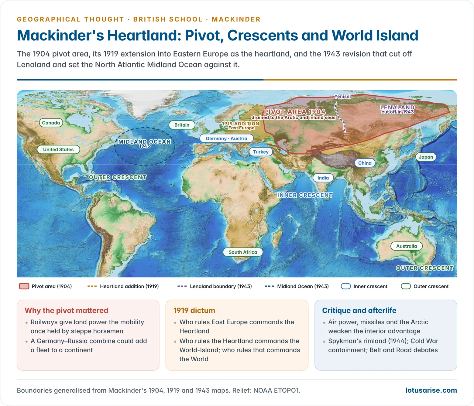
- In “The Geographical Pivot of History“, read at the RGS and printed in The Geographical Journal in 1904, Mackinder offered a global model of power. It became a foundation of geopolitics.
- Reasoning:
- The Columbian epoch of sea power, from the voyages of discovery onward, was ending, since few lands were left to claim.
- From the 5th to the 16th century, mounted nomads from the steppes of central Asia had pressed on Europe and on the settled margins of Asia.
- Railways could now give a land power the mobility that the horse and camel had given the nomads.
- The pivot area was the inner part of Eurasia drained to the Arctic or to inland seas (Caspian and Aral). It lay beyond the reach of naval power and was largely held by Russia.
- Around it lay the inner or marginal crescent: Germany, Austria, Turkey, India and China, the coastlands of Eurasia open to sea power.
- Beyond the seas lay the outer or insular crescent: Britain, South Africa, Australia, the United States, Canada and Japan.
- An alliance of Germany and Russia, or a Russia overrun by a Japanese-organised China, could build a fleet on the resources of the continent. France, Italy, Egypt, India and Korea would then become bridgeheads for the outside navies.
- Democratic Ideals and Reality (1919) renamed the pivot the heartland. It extended the area to take in Eastern Europe and the Black Sea and Baltic basins, and used the term World Island for Europe, Asia and Africa together.
- Its dictum: “Who rules East Europe commands the Heartland; who rules the Heartland commands the World-Island; who rules the World-Island commands the World.”
- In “The Round World and the Winning of the Peace” (Foreign Affairs, 1943) he cut off Lenaland, the Soviet lands east of the Yenisei, from the heartland. He set against the heartland a Midland Ocean: the North Atlantic, with eastern North America and western Europe.
| Version | Name of the core | Extent | Key idea |
|---|---|---|---|
| 1904 | Pivot area | Inner Eurasia drained to the Arctic and inland seas | Railways give land power the edge over sea power |
| 1919 | Heartland | Pivot plus Eastern Europe, Black Sea and Baltic basins | Control of East Europe decides control of the World Island |
| 1943 | Heartland less Lenaland | Soviet lands west of the Yenisei | Heartland balanced by the North Atlantic “Midland Ocean” |
- Criticism:
- It is a simplified model that sacrifices much truth for clarity, and it leans on environmental determinism.
- Air power, missiles and satellites reduce the value of an interior position. The Arctic has become a strategic zone between the great powers.
- Nicholas John Spykman’s rimland thesis (1944) argued that power lay in the coastal crescent, not the interior.
- Karl Haushofer’s German Geopolitik drew on the theory, which tainted it after 1945.
- Legacy: it framed Cold War containment of the Soviet Union, and it is still invoked in debates on Russia and Eastern Europe and on China’s Belt and Road corridors across inner Asia.
Hugh Robert Mill (1861–1950)
- Hugh Robert Mill was RGS librarian from 1892 and director of the British Rainfall Organization from 1901. Under him, rainfall maps of Britain were drawn from 50-year averages.
- Trained in the Darwinian environmental tradition and influenced by Otto Schlüter’s morphological approach, he widened physiography to include the geography of man, but only those aspects derived from the physical setting.
- He pictured the spatially distributed phenomena of Ferdinand von Richthofen’s system as a pyramid: a physical base with human and economic features above.
- He saw water as the key element: it sustains life and supplies the only inexhaustible energy. His The Realm of Nature (1891) gave it a central place.
- In 1896 he proposed recording land quality and land use on Ordnance Survey sheets for the whole country. The plan was shelved for its cost, but it anticipated Stamp’s survey of the 1930s.
- He also wrote on polar exploration, including the first full biography of Ernest Shackleton (1923).
George Goudie Chisholm (1850–1930)
- George Goudie Chisholm pioneered commercial geography in Britain. His Handbook of Commercial Geography (1889) organised information on products, trade and transport that the trading empire needed.
- He tried to introduce Alfred Hettner’s idea of chorology into British geography.
Patrick Geddes (1854–1932)
- Patrick Geddes, a Scottish biologist, sociologist and town planner, approached geography from a biological angle. He was drawn to the Darwinian idea of ordered evolutionary unity.
- He was influenced by Paul Vidal de la Blache and by the French sociologist Frédéric Le Play, who studied family life through household budgets.
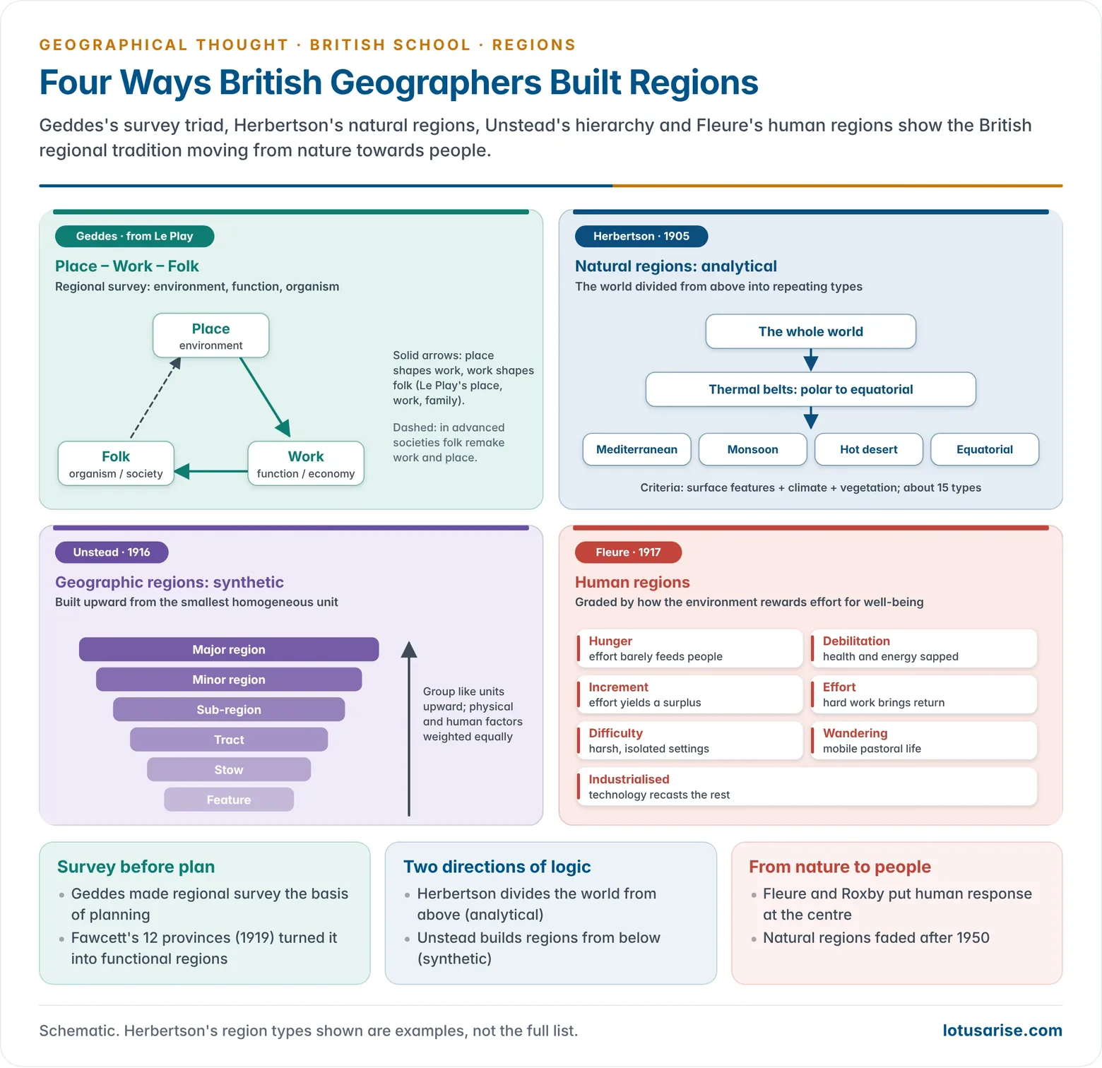
- Le Play’s triad Place–Work–Family (Lieu, Travail, Famille) held that environment shapes work, and work shapes family and society.
- Geddes turned it into Place–Work–Folk (environment, function and organism; or geography, economics and anthropology). In advanced societies the sequence could run in reverse: Folk–Work–Place.
- Regional survey: his motto was “survey before plan”. A region’s geology, climate, economy and institutions must be surveyed before any planning.
- His Outlook Tower in Edinburgh (1892) served as a “sociological laboratory” for seeing a city in its region. His Valley Section linked relief, occupations and settlement from hill to sea.
- In Cities in Evolution (1915) he coined the word conurbation.
- He held that geography should be an applied science, concerned with what ought to be. His method shaped British regional study and town planning between the wars.
- India: between 1915 and 1919 Geddes wrote town-planning reports for well over a dozen Indian cities, among them Indore (1918). He then held the chair of sociology and civics at the University of Bombay. He favoured “conservative surgery”, improving old quarters instead of clearing them.
Andrew John Herbertson (1865–1915)
- Andrew John Herbertson worked as Geddes’s assistant in Dundee and became Mackinder’s assistant at Oxford in 1899. He succeeded him as head of the School in 1905 and became Professor in 1910.
- In “The Major Natural Regions: An Essay in Systematic Geography” (Geographical Journal, 1905) he divided the world into about 15 natural regions. He defined them by the association of surface features, climate and vegetation, relying on Alexander Supan’s climatic data.
- The same region types recur in similar positions on each continent, for example the Mediterranean type on western margins in warm temperate latitudes.
- His regions were types, so widely separated areas fell in one class. This is analytical regionalisation: dividing the world from above on chosen principles.
- He saw a region as a macro-organism, an ordered association of inorganic and living matter with structure and function. This view is often read as a precursor of the ecosystem concept.
- He believed every natural region carries its own imprint of the man–environment relationship, though he leaned to the physical base, and he grew more deterministic than Geddes.
- As secretary of the Geographical Association and editor of The Geographical Teacher, he spread natural regions through school textbooks for half a century. After 1950 the idea faded as geographers stressed human agency in making regions.
The Regional Geographers
- Regional study gained a professional footing early in the 20th century under the influence of the German Landschaft and the French pays, and most of all of Vidal de la Blache and Le Play through Geddes.
Marion Isabel Newbigin (1869–1934)
- In Man and His Conquest of Nature (1912) she asked why it is easier to make a living in some places than others. The answer lay in the relation between genre de vie and the productivity of the land.
- Her work carried the Vidalian tradition into Britain.
John Frederick Unstead
- John Frederick Unstead (1916) gave physical and human factors equal weight. He built regions upward from the smallest unit, the feature, through stow, tract, sub-region and minor region to the major region.
- This is synthetic regionalisation, the opposite of Herbertson’s analytical method. Its weakness was the idea of an indivisible homogeneous “stow”.
Charles Bungay Fawcett (1883–1952)
- In The Provinces of England (1919) Charles Bungay Fawcett proposed 12 provinces, each organised round a regional capital, with boundaries along watersheds.
- It was one of the first statements of functional regions. He also mapped Britain’s conurbations, using Geddes’s term.
Herbert John Fleure (1877–1969)
- Herbert John Fleure was a zoologist and anthropologist who held the chair of geography and anthropology at Aberystwyth from 1917 and the first chair of geography at Manchester from 1930.
- He studied human problems in terms of space, time and type. With Harold Peake he wrote The Corridors of Time (10 volumes, 1927–56). His other works include Human Geography in Western Europe (1918).
- His human regions (1917) classified the world by how far the environment rewards effort towards well-being. He named seven: regions of hunger, debilitation, increment, effort, difficulty, wandering, and industrialised regions.
- He rejected the idea that environment alone shapes a region. This made him a forerunner of cultural and social geography in Britain.
Percy Maude Roxby (1880–1947)
- Percy Maude Roxby, professor at Liverpool from 1917, set out how a regional study should proceed. It begins by demarcating natural regions by geology, drainage, coastline, climate and vegetation, and then examines man’s relation to that environment.
- He distinguished the human region from the natural region. Differences in human relations can create distinct human regions within one natural region.
- He developed the idea of modes of livelihood in the tradition of Le Play and Vidal, and built a specialism on China.
| Geographer | Year | Basis of regions | Method |
|---|---|---|---|
| Herbertson | 1905 | Surface, climate, vegetation | Analytical (world divided into types) |
| Unstead | 1916 | Physical and human factors equally | Synthetic (feature to major region) |
| Fleure | 1917 | Environment’s reward for human effort | Human regions (seven types) |
| Fawcett | 1919 | Regional capitals and watersheds | Functional provinces (12 for England) |
| Roxby | 1920s | Natural region first, then human relations | Natural to human regions |
- Regional specialisation and India: British geographers also devoted careers to single world regions, as Roxby did with China. Oskar Hermann Khristian Spate’s India and Pakistan: A General and Regional Geography (1954), revised with A. T. A. Learmonth (1967), became the standard regional geography of the subcontinent.
Sidney William Wooldridge (1900–1963)
- Sidney William Wooldridge taught at King’s College London and was a founder member of the IBG. He held that physical geography is the platform on which all human activity rests.
- With R. S. Morgan he wrote The Physical Basis of Geography: An Outline of Geomorphology (1937). He studied the denudation chronology of south-east England in The Weald (1953).
- He set out the scope and method of the subject in The Spirit and Purpose of Geography (1951, with W. Gordon East) and The Geographer as Scientist (1956). He was a strong advocate of fieldwork.
Laurence Dudley Stamp (1898–1966)
- Laurence Dudley Stamp taught geology and geography at the new University of Rangoon (1923–26) and then economic and social geography at the London School of Economics.
- He organised the Land Utilisation Survey of Britain in the 1930s.
- Volunteers, many of them schoolchildren and their teachers, mapped every field at 6 inches to the mile. The results were published as one-inch maps and county reports (1933–48).
- The maps guided wartime food production under blockade and became a basis for post-war planning. Stamp was vice-chairman of the Scott Committee on land utilisation in rural areas (1941–42).
- His The Land of Britain: Its Use and Misuse (1948) and Applied Geography (1960) made him the leading voice of applied geography.
- He moved the IGU to set up a World Land Use Survey (1949). He was IGU President (1952–56) and was knighted in 1965.
- His many books include Asia: A Regional and Economic Geography (1929) and The Geography of Life and Death (1964).
Historical Geographers
- Henry Clifford Darby (1909–1992) built historical geography on cross-sections of past geographies. Their timing was set by the sources, above all the Domesday Book (1086), analysed county by county in the Domesday Geography series. Narratives of change linked the cross-sections.
- Eva Germaine Rimington Taylor, Edmund William Gilbert and W. Gordon East contributed studies of early maps, past regions and the historical geography of Europe.
- William Kirk offered a humanistic alternative. He distinguished the phenomenal environment (the real world) from the behavioural environment (the world as people perceive it), and held that the second explains past decisions.
- Harold Brookfield studied a trilogy of the real, abstract and perceived worlds. Their work opened the way for behavioural geography.
Chorley, Haggett and the New Geography
- Richard John Chorley (1927–2002), a geomorphologist at Cambridge, applied general systems theory to landforms (“Geomorphology and General Systems Theory”, 1962). He argued for open systems in place of the closed Davisian cycle.
- Peter Haggett (1933–2025), who worked at Cambridge and then Bristol, wrote Locational Analysis in Human Geography (1965) and Geography: A Modern Synthesis (1972).
- Together they edited Frontiers in Geographical Teaching (1965) and Models in Geography (1967).
- These collections brought the quantitative revolution to British teachers and researchers. Models in Geography used Thomas Kuhn’s idea of the paradigm to argue for a new model-based geography.
- David Stoddart brought the ecosystem concept into geography as a monistic framework uniting man, environment and biota.
- David Harvey (born 1935), a Cambridge graduate, codified positivist method in Explanation in Geography (1969). He then turned to Marxism in Social Justice and the City (1973) and became a leader of radical geography.
Disciplinary Trends in British Geography
- After the First World War, British geography developed five distinctive features: a continuing interest in exploration; regional study of several kinds; fieldwork and map interpretation in training; historical geography; and the relevance of geography to economic, social and political problems.
- Economic geography flourished between the wars. It concentrated on the natural factors in the location of resources, crops and industries.
- Robert Ogilvie Buchanan’s The Pastoral Industries of New Zealand (1935) related farming and industry to the physical environment.
- Wilfred Smith’s An Economic Geography of Great Britain (1949) analysed regional variation in production from statistics, an ecological approach ahead of its time.
- Cyril Daryll Forde’s Habitat, Economy and Society (1934) showed that culture and cultural contact, more than environment, shape a people’s mode of life.
- Regional geography dominated before and just after the Second World War. It also had an applied face, in the Civil Defence regions of 1939 and the planning regions drawn by Taylor and Gilbert in the 1940s.
- Agricultural and land-use geography rose with Stamp’s survey and post-war planning. It was the first large example of applied geography in Britain.
- Historical geography grew strongly after 1918, from Mackinder’s call to reconstruct past geographies to Darby’s cross-sections and Kirk’s behavioural environment.
- Settlement geography developed slowly. Fleure and his followers studied rural settlement, but the internal spatial structure of cities received little attention until after 1950.
- Physical geography, especially geomorphology, remained strong, from Wooldridge’s denudation chronology to Chorley’s systems approach.
| Branch | Leading British figures | Main concern |
|---|---|---|
| Political / historical | Mackinder, Darby, Taylor, East | Global strategy; past geographies |
| Regional | Herbertson, Unstead, Fleure, Roxby, Fawcett | Natural, human and functional regions |
| Economic / commercial | Chisholm, R. O. Buchanan, W. Smith | Location of resources, trade, industry |
| Land use / applied | Mill, Stamp | Survey, planning, food production |
| Physical | Mill, Wooldridge, Chorley | Rainfall, landforms, systems |
| Spatial science | Haggett, Chorley, Harvey (early) | Models, locational analysis |
Current Trends in British Geography
- From regions to spatial science: by the 1950s, dissatisfaction with the empiricism of the regional paradigm turned British geographers towards systematic specialisms. By the early 1960s the quantitative and theoretical revolution had redefined the subject as a spatial science of pattern, process and hypothesis testing.
- Successive approaches were then layered on spatial science:
- Behavioural and humanistic geography (Kirk, Brookfield) emphasised perception, values and experience.
- Radical and Marxist geography developed through Harvey and Doreen Massey’s Spatial Divisions of Labour (1984).
- Welfare geography developed through David M. Smith’s Human Geography: A Welfare Approach (1977).
- The journal Area (from 1969) carried debates on relevance: inequality, poverty, public policy and power.
- Philosophical range: British geography now draws on positivism, pragmatism (borrowed from American thought and aimed at practical problems), realism (as against idealism), existentialism and humanism, a modified environmental causation, and dialectical materialism.
- Feminist and cultural turns: the Women and Geography Study Group published Geography and Gender (1984). Denis Cosgrove and Peter Jackson (Maps of Meaning, 1989) led a new cultural geography, and Nigel Thrift developed non-representational theory, which studies practice and feeling rather than representation alone.
- Institutions: the RGS and the IBG merged in 1995 as the RGS–IBG, joining the exploring and the academic traditions.
- Recent directions:
- GIS and spatial data science.
- Climate change, hazards and environmental management.
- Medical and health geography.
- The new regional geography of localities.
- Decolonising geography, the theme the RGS–IBG chose for its 2017 annual conference, which also confronts the subject’s imperial origins.
Evaluation
- Strengths:
- The school had a durable field and survey tradition, from Huxley’s local physiography to Stamp’s national mapping.
- It made an applied contribution to planning, land use and policy.
- It refused to split physical from human geography.
- It produced world-scale ideas, the heartland and natural regions, that travelled far beyond Britain.
- Limitations:
- It professionalised late and was long tied to exploration and empire.
- Its early natural regions and the heartland carried a deterministic bias.
- It was less concerned with philosophy and method than American geography before 1950.
- Its regional writing tended to stay descriptive until the spatial and critical revolutions.
- Set beside the German, French and American schools, the British school stands out for turning geography into a practical, policy-minded discipline. After 1960, British geographers also led the theoretical debates of the subject.
Previous Year Questions
- No direct PYQ has been asked on this sub-topic yet.




