

- Heartland and Rimland are the two classic models of geopolitics, the study of how geographical position, resources and movement shape the power of states.
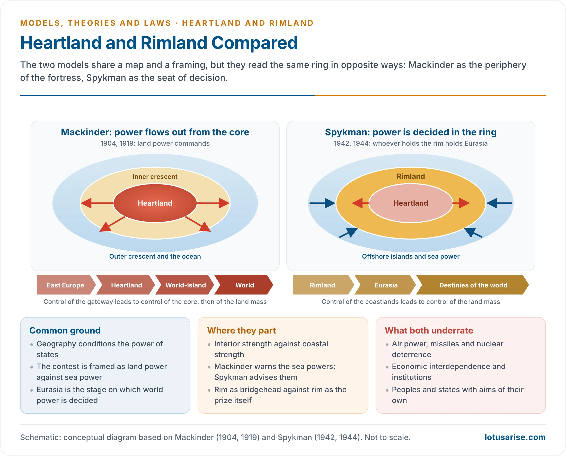
- Halford John Mackinder (1904, 1919, 1943) argued that the closed interior of Eurasia is the natural seat of world power. Nicholas John Spykman (1942, 1944) replied that power is decided in the coastal ring around it.
- Both read history as a contest of land power and sea power, a contrast that begins with Alfred Thayer Mahan’s sea power thesis of 1890.
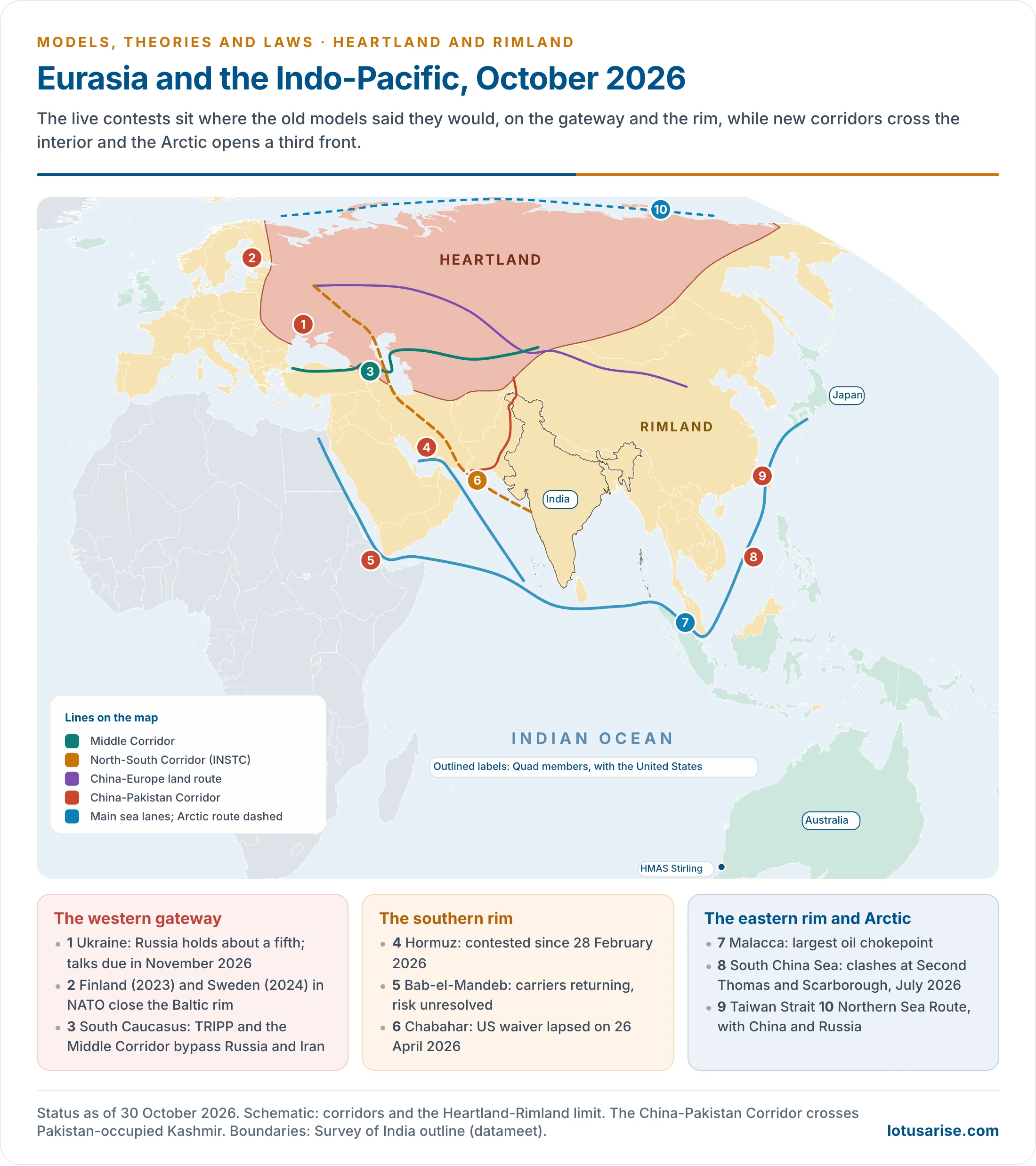
- The models survive because the wars and corridors of 2026 still fall on the gateway Mackinder named and the rim Spykman named, though neither model explains them alone.
Geopolitics and the Land-Sea Contest

- The term Geopolitik was coined by the Swedish political scientist Rudolf Kjellén in 1899. Its German form turned into a programme of expansion, the doctrine of Lebensraum.
- Geopolitics joins geo and politics: it studies how a state’s polity and power change with geographical conditions, read across space and time.
- Thinkers in this tradition treat political history as shaped by geographical causation: location, accessibility and resources set the limits within which states act.
- Sea power rests on long coasts, ports, shipping and cheap movement. India, with its long coastline, is the regional case.
- Mahan’s case for it was easy and fast movement, port facilities and better trade. Britain, France, Portugal, Spain, Italy and Germany all built colonial empires by sea.
- Land power rests on interior position, contiguous territory and overland mobility. Land-locked Nepal is the extreme case on a small scale.
- Its case rests on location, inaccessibility and resources. Most natural resources lie on land, as with uranium for nuclear energy, so Mackinder treated location and resources together as the basis of supremacy.
- Mahan held sea power to be superior. Mackinder offered the antithesis: railways were ending the age of naval advantage.
Mackinder’s Heartland Theory
The Pivot Area, 1904
- Mackinder (1861–1947), whose career belongs to the British school, read “The Geographical Pivot of History” at the Royal Geographical Society on 25 January 1904. It appeared in The Geographical Journal that April.
- Assumptions:
- Land and sea power are the two great forms of mobility, and history is their contest.
- Geography is more measurable and more nearly constant than the human factors in power.
- The closed political system of the post-exploration world means any shift of power is now felt everywhere.
- Mechanism:
- The Columbian epoch of about 400 years, in which Europe expanded by sea against little resistance, ended soon after 1900.
- The Age of Discoveries, from Columbus on, gave Europe its pivotal role in that epoch, and the rise of land-based powers was now eclipsing it.
- From the 5th to the 16th century, steppe horsemen (Huns, Avars, Magyars, Mongols and others) pressed on the settled margins. That pressure helped forge Europe.
- Euro-Asia measures about 21 million square miles. Its centre and north, about 9 million, have no waterway to the ocean: the Volga, Oxus and Jaxartes end in salt lakes, and the Obi, Yenisei and Lena in the frozen Arctic.
- Transcontinental railways now give that interior the mobility once held by the horse and camel, in an area “inaccessible to ships”.
- The Columbian epoch of about 400 years, in which Europe expanded by sea against little resistance, ended soon after 1900.
- He called the area the pivot and also used the word “heart-land” in 1904; “Heartland” became the formal name in 1919.
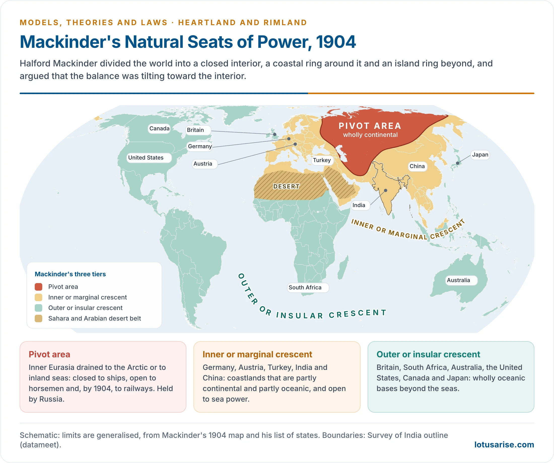
- The pivot took in Siberia and the Central Asian lands of present-day Kazakhstan, Uzbekistan, Tajikistan, Kyrgyzstan and Turkmenistan. Ice-bound Arctic seas closed it to the north, the Central Asian highlands to the south and the East Siberian highlands to the east, and he saw it as a natural fortress, the citadel of the world, closed to sea power.
- He credited the interior with mineral, water, soil and forest wealth.
- Most old civilisations lay in the inner crescent, which matched the pre-Columbian Old World and included South-West Asia and North Africa. The outer crescent, with the Pacific islands and Oceania, was marked by its complete insularity from the Eurasian mainland.
| Tier | Character | Extent | States he named |
|---|---|---|---|
| Pivot area | Wholly continental | Volga to eastern Siberia, Arctic to the Central Asian highlands, with the Iranian upland | Russia |
| Inner or marginal crescent | Partly continental, partly oceanic | Coastlands draining to navigable seas: Europe, Nearer East, monsoon Asia | Germany, Austria, Turkey, India, China |
| Outer or insular crescent | Wholly oceanic | Lands beyond the seas | Britain, South Africa, Australia, United States, Canada, Japan |
- Outcome:
- The danger was an oversetting of the balance toward the pivot state. Its expansion over the margins would allow “the use of vast continental resources for fleet-building, and the empire of the world would then be in sight”.
- That could come from a Germany allied with Russia, or from a Chinese force organised by Japan overrunning Russia.
- The sea powers would answer through bridgeheads in France, Italy, Egypt, India and Korea. Mackinder asked whether this was the strategic function of India in the British imperial system.
- Marginal lands: he saw four, matching four great religions: the Pacific and Indian monsoon lands (Buddhism, Brahminism), Europe (Christianity) and the Nearer East (Islam), the last being the weakest spot in the girdle.
- India in 1904: a monsoon land of the inner crescent, open to the sea on three sides. Britain held it by sea and feared Russian pressure toward its north-west passes.
The Strategic Heartland, 1919
- Democratic Ideals and Reality (1919) was a peace-time warning to the statesmen at Versailles.
- Why he changed the model:
- In the Great War, land power closed the Baltic and the Dardanelles to the fleets, so drainage alone no longer marked the limit of sea power.
- Germany’s bid in East Europe showed that an organiser from outside the old pivot could reach for it. The revolution in Russia left the interior open.
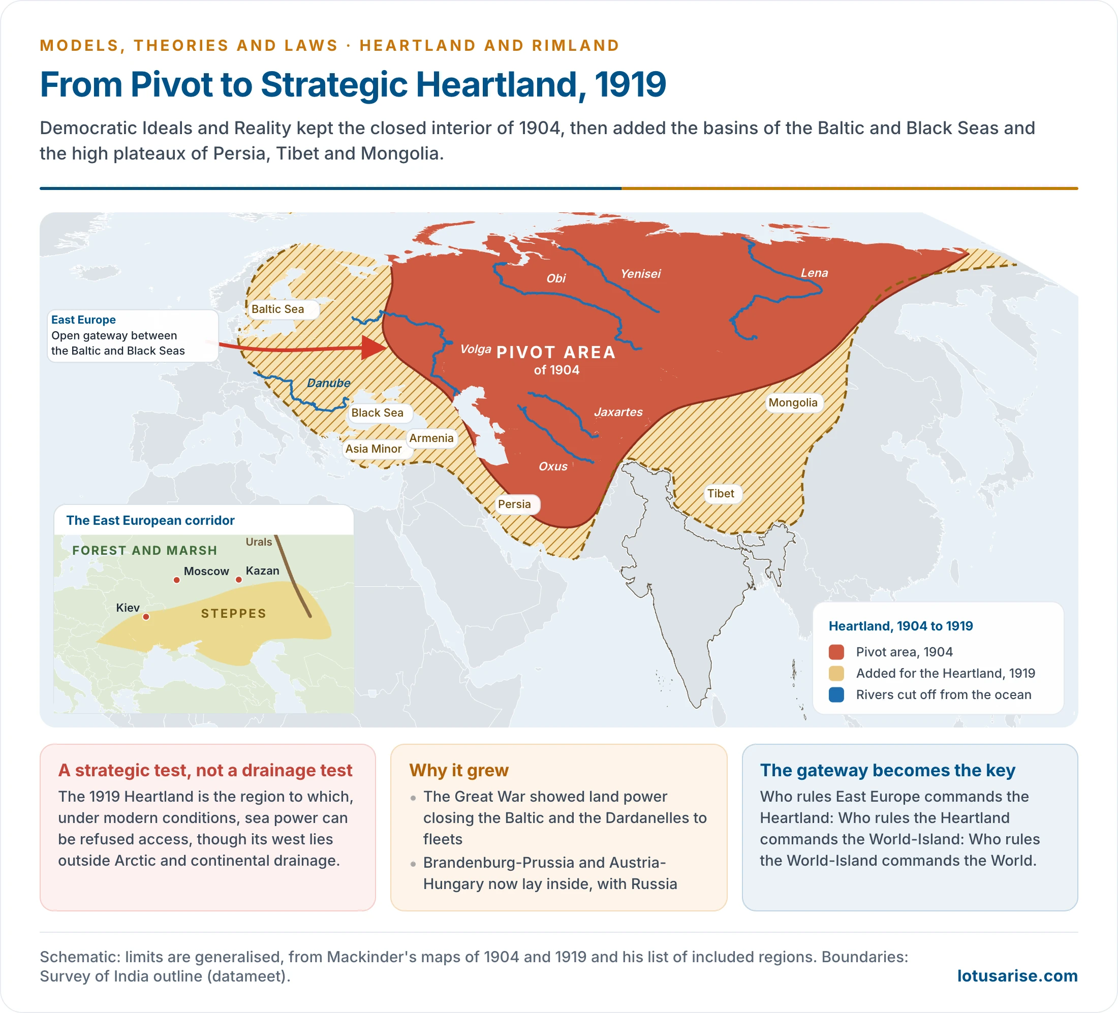
- New definition: the Heartland is “the region to which, under modern conditions, sea-power can be refused access“, though its west lies outside Arctic and continental drainage.
- New extent: it “includes the Baltic Sea, the navigable Middle and Lower Danube, the Black Sea, Asia Minor, Armenia, Persia, Tibet, and Mongolia”. Brandenburg-Prussia and Austria-Hungary now lay inside it.
- World-Island: Europe, Asia and Africa form one Great Continent. It covers two-twelfths of the globe against nine-twelfths of ocean and one-twelfth of other land, and holds more than fourteen-sixteenths of humanity.
- That makes it about two-thirds of the land and seven-eighths of the people. Africa south of the Sahara became a Southern Heartland, and the Americas and Australia became satellites.
- The gateway: the plain between the Baltic and Black Seas is the weak side of the fortress. Its steppe corridor, between the forest to the north and the Black Sea and Caucasus to the south, reaches through the steppes of Ukraine and carried the invasions of the past.
- The strategic argument: the Heartland is the strongest natural fortress on earth, with the resources of a trans-continental area. Any power that organised it effectively could found a world empire.
- The Bolshevik Revolution of 1917 and the fall of the Russian empire made him more assertive, since the interior now seemed open to a new organiser.
- India in 1919: the added plateau of Tibet overlooks the upper valleys of the Indian rivers, and he traced the north-west entries to India from the interior. The limit runs along the Himalaya, so the subcontinent stays outside.
- The dictum, in his words:
- “Who rules East Europe commands the Heartland: Who rules the Heartland commands the World-Island: Who rules the World-Island commands the World.”
- Prescription: a Middle Tier of independent states from the Baltic to the Adriatic and Black Seas, to keep Germany and Russia apart.
The Round World and the Midland Ocean, 1943
- “The Round World and the Winning of the Peace” (Foreign Affairs, July 1943) was written at the age of 82, four years before his death. It extended the model rather than reversing it: he called the Heartland “more valid and useful today than it was either twenty or forty years ago”.
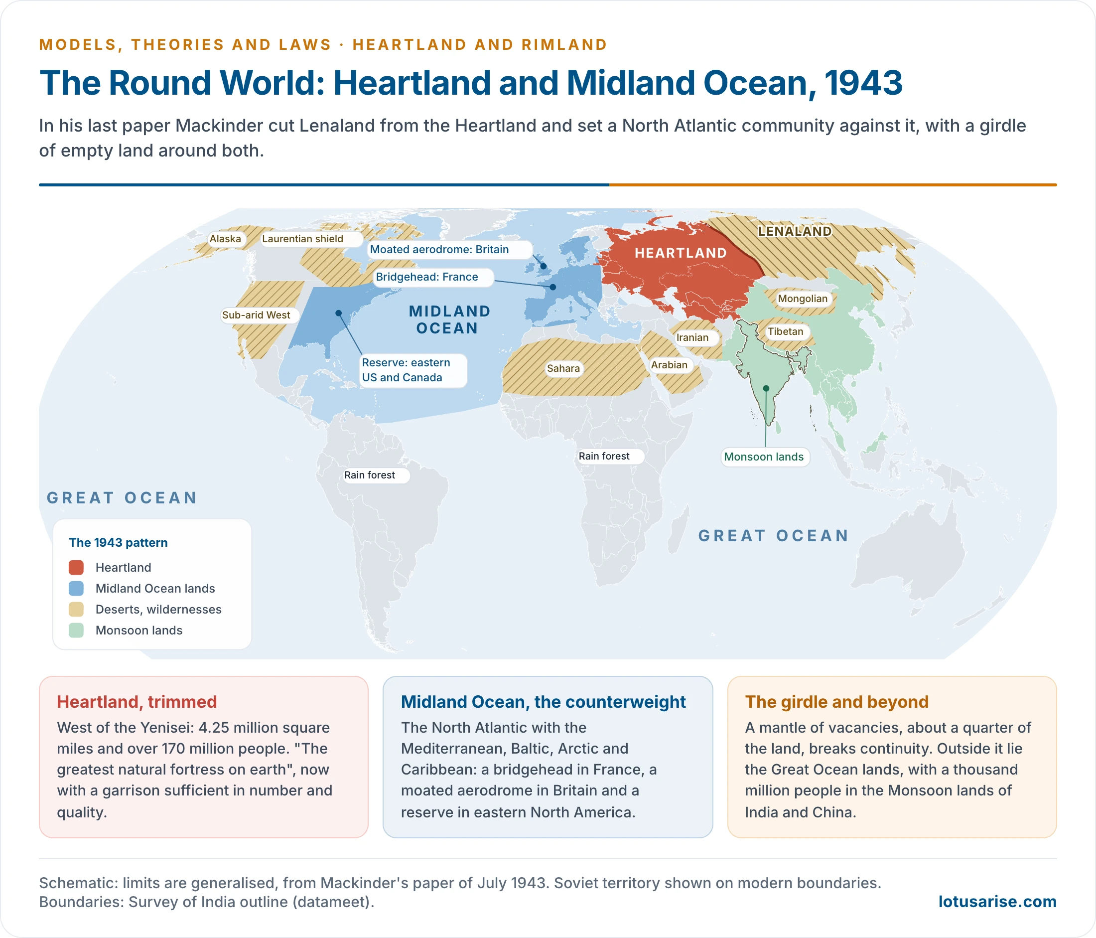
- Heartland trimmed: the USSR west of the Yenisei, with about 4.25 million square miles and over 170 million people. It was “the greatest natural fortress on earth“, and for the first time “manned by a garrison sufficient both in number and quality”.
- Lenaland: Soviet land east of the Yenisei, rugged and forested, with 3.75 million square miles and only about 6 million people. It now formed part of the fortress wall.
- Midland Ocean: the North Atlantic with the Mediterranean, Baltic, Arctic and Caribbean. Mackinder had seen the west of Europe and the east of North America as physical complements since the 1920s. He now gave the concept three elements:
- He treated Western Europe (France, Belgium, Britain) and North America as lands joined by the Atlantic, not parted by it, and the United Kingdom and New England as sharing one civilisation. This made the area a counterweight to the Heartland.
- a bridgehead in France;
- a moated aerodrome in Britain;
- a reserve of manpower, farming and industry in eastern North America.
- Girdle of deserts and wildernesses: from the Sahara through the Arabian, Iranian, Tibetan and Mongolian deserts to Lenaland, Alaska, the Laurentian shield and the sub-arid western United States. It would long “break social continuity” between the major communities.
- This empty belt, in his view, would also help stop conflict spreading between the major communities.
- Outer pattern: the Great Ocean lands, the tropical rain forests, and a thousand million people in the Monsoon lands of India and China, who must grow to prosperity for a “balanced globe“. India thus enters his last scheme as a future weight, no longer as a bridgehead.
| Version | Core | Limit | Counterweight | Context |
|---|---|---|---|---|
| 1904 | Pivot area | Arctic and inland drainage | Crescent bridgeheads | Railways; Russo-British rivalry |
| 1919 | Heartland | Region closed to sea power; Baltic and Black Sea added | Middle Tier; League of Nations | Versailles; German-Slav contest |
| 1943 | Heartland less Lenaland | USSR west of the Yenisei | Midland Ocean | Soviet resistance; coming peace |
Applying the Model
| Period | Events | Reading |
|---|---|---|
| To 1945 | Karl Haushofer’s German Geopolitik drew on the thesis; Nazi-Soviet pact (1939); invasion of the USSR (1941) | A Germany-Russia combination, then a bid to seize the gateway; the garrison held |
| Cold War, 1945–91 | Soviet control of East Europe; US-UK Atlantic alliance; Cuban Missile Crisis (1962), a response to US missiles near Soviet soil | Heartland against Midland Ocean, the two centres of 1943 |
| Indian Ocean after empire | Britain lost Suez (1956) and left east of Suez by 1971; US bases followed, as at Diego Garcia | Outside powers entered the crescent to balance the Heartland power |
| After 1991 | Soviet collapse; a unipolar moment; Shanghai Cooperation Organisation (2001); BRICS | Heartland broken up, yet Russia kept its arms and alignments; a shift to many poles |
- West Asia in the Cold War: the crescent’s oil and transit position drew both blocs. The USSR backed Iraq and later intervened in Afghanistan, while the United States aligned with Saudi Arabia and Israel.
- Other Cold War readings: the rivalry set capitalism against socialism in the Heartland-Midland frame, and Korea and Vietnam showed the balance of power at work on the rim.
- Indian Ocean before empire’s end: the ocean had been called first a Portuguese and then a British lake. Egypt’s seizure of Suez and Britain’s withdrawal opened it to the United States, on the argument that a balance against the USSR was needed.
- After 1991: Russia lost economic weight but not its arms or alignments. Its annexation of Crimea in 2014 returned attention to the gateway, and talk of a Moscow, Beijing and New Delhi triad runs through BRICS.
- The dictum tested: by 1945 Moscow ruled East Europe and the Heartland, yet it never commanded the World-Island. Containment from the rim and a weak civilian economy stopped it.
- Bolshevik Russia to 1945: the Bolshevik Revolution, Germany’s defeat in 1918 and the later spread of communism across East Europe all seemed to bear out the attention on that region.
Criticism
- Determinism: history is reduced to land against sea, and to geography. Physical, economic and cultural forces all act, and human technology overrides terrain, as possibilists argue.
- Area is not power: he inflated the interior‘s resource and power potential. Much of it is cold or arid waste that cannot feed a large population, and it is ringed by ice and mountains.
- The Sahara shows that vast area can be barren. Extreme cold in winter and heat and aridity in summer also leave the interior at a disadvantage.
- Outdated technology: he wrote as the rail age peaked and the air age began. Fighters and missiles leave the fortress open from all sides, and nuclear deterrence changed the calculation.
- Flat-map thinking: critics charge him with a Mercator-style image of a vast Arctic gap. North America and Siberia in fact face each other across the Bering Strait and the polar route, only hundreds of miles apart. His own 1904 maps were on an equal-area base, and “the round world” of 1943 answers part of this charge.
- Unused potential: the Heartland has never organised itself into world dominion, and Soviet power collapsed.
- Tainted use: the thesis fed Geopolitik, and geopolitics migrated from Germany to North America after 1945.
- Nuclear deterrence after the bombing of Japan in 1945, and science and technology generally, have made the configuration of the surface matter less than it did in 1904. Geopolitics is now shifting towards Asia, with China and India as new centres.
- A defence: W. H. Parker (1982) tested about a hundred such criticisms and found many rest on misreading. Mackinder himself said the concept could not be precisely mapped.
Spykman’s Rimland Theory
Author and Premises
- Nicholas John Spykman (1893–1943) was a Dutch-born American scholar who founded the Yale Institute of International Studies in 1935.
- America’s Strategy in World Politics (1942) judged power from the US position: America is surrounded by the Old World, so its security needs a balance of power in Europe and the Far East.
- Six months before Stalingrad he warned that “a Russian state from the Urals to the North Sea can be no great improvement over a German state from the North Sea to the Urals”.
- The Geography of the Peace (1944) appeared after his death in June 1943 and set out the Rimland map.
- Premises shared with Mackinder: geographical causation and the land-sea contest. National power is the final guarantee of security, and lasting peace needs a balance of power or an armed league.
- Against Mackinder: sea power has greater speed and accessibility, and coastal states hold more than two-thirds of the world’s people and most of its technical skill. Hills, rivers and deserts make interior land harder to reach.
The Two Tiers
| Tier | Spykman’s view |
|---|---|
| Heartland (inner core) | Extreme climate; farming centred in the west, not Siberia; little arable land; rivers, mountains and distance hinder movement. A power centre only in the distant future, and not sealed, since steppes and valleys give access |
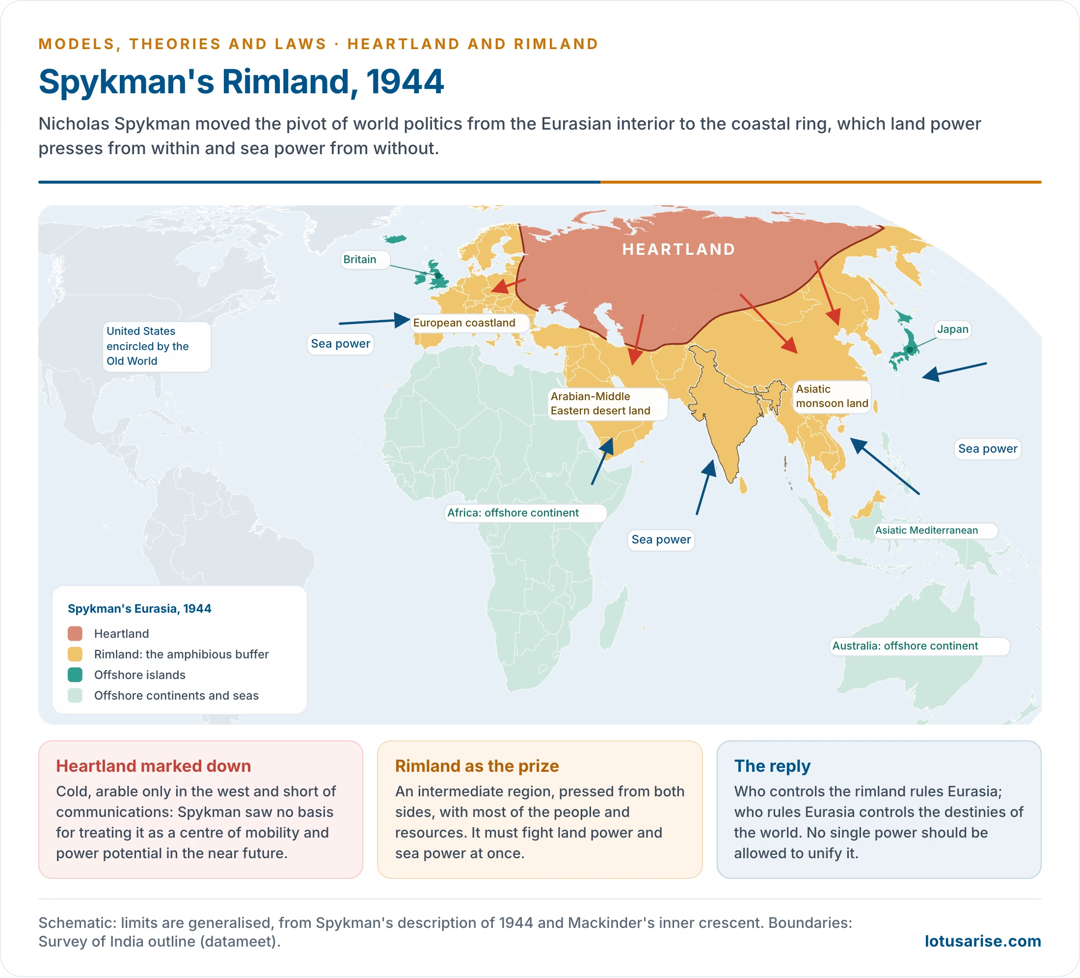
| Rimland | Mackinder’s inner crescent renamed: an amphibious buffer between land and sea power, with most of the people and resources, which must defend itself on both sides |
- Three sections: the European coastland, the Arabian-Middle Eastern desert land and the Asiatic monsoon land, the last holding India and China.
- Spykman saw the inner core’s resources as dormant and its people as thin on the ground and scattered. Central Asian deserts, steppes, low mountains and river valleys gave several gateways, so it was neither a natural fortress nor protected land.
- Beyond the rim: the offshore islands of Britain and Japan, the offshore continents of Africa and Australia, and the sea lanes that link them.
- The reply, recast from Mackinder’s slogan:
- “Who controls the rimland rules Eurasia; who rules Eurasia controls the destinies of the world.”
- The logic: the Heartland appeared less important than the Rimland. Spykman argued that a combination of land and sea powers holding the rim would command the essential power relations of the world. The US aim was therefore to prevent any unification of the Rimland by a hostile power.
- Writing during the Second World War, he wanted Allied foreign policy to rest on preventing any hostile consolidation of the rim.
- Maritime mobility: the overseas empire is a new kind of structure, unlike land empires built on contiguous territory. Sea power lets Eurasia be conceived as a unit, and it governs relations between the Old and New Worlds.
- Terrain and policy: topography, terrain and climate are treated as basic conditions of foreign policy because they change least.
Applications
- Containment: with Germany defeated and the USSR sole master of the Heartland, the logic matched US policy after George F. Kennan’s 1947 article.
- Pacts of this kind aimed to keep Soviet influence out of the warm waters of the rim. The Cuban Missile Crisis and the US National Missile Defence strategy belong to the same contest.
- A chain of pacts ringed the Soviet Union: NATO (1949), ANZUS (1951), SEATO (1954) and the Baghdad Pact (1955), later CENTO. The domino theory followed the same reasoning.
- Wars on the rim: Korea, Vietnam, the Sino-Indian War, the Arab-Israeli and Indo-Pakistani wars, the Gulf wars, Afghanistan, Iran and Iraq were all fought there.
- Regional bodies: ASEAN, the Indian Ocean Rim Association (once IOR-ARC) and BIMSTEC seek to organise rim states, and the US rebalance to Asia and forums such as the Raisina Dialogue reflect the same interest.
- India: Kavalam Madhava Panikkar, in India and the Indian Ocean (1945), wrote that “whoever controls the Indian Ocean has India at his mercy”. His argument, built on Mahan, gives Rimland logic an Indian form, and it runs through the geopolitics of the Indian Ocean and South Asia.
- He drew on British rule: command of the sea in time brings command of the land beside it. Earlier conquerors who came by land were absorbed into India, while the British stayed apart because naval supply lines tied them to home.
Oil as a Geopolitical Weapon
- West Asia’s oil shows how much of the rim’s value lies in resources. In 1973 Arab producers cut output and embargoed the United States and others over support for Israel, and prices surged.
- The weapon has limits: buyers built reserves and pipelines, and Gulf states need the revenue. US crude output rose from 5.2 to 13.6 million barrels a day between 2005 and 2025.
- Gulf producers still supplied about 28% of world oil in 2025. The 2026 energy crisis moved the lever from the producer’s tap to control of the passage at Hormuz.
Criticism
- War technology and nuclear deterrence weaken any claim for a decisive zone.
- Spykman underrated the United Nations and world opinion. International law bars conquest, and the organic state of Friedrich Ratzel has no legal footing now.
- Lebensraum, which treated the state as a living organism and fed Adolf Hitler’s Greater German Reich, is out of place in a world where international law bars territorial expansion.
- Economic dependence now does much of the work once done by territorial control, as with the flood of Chinese goods into Indian markets. India’s trade gap with China reached US$ 112.16 billion in 2025-26.
- The rim is not one unit: its states pursue their own aims and rival one another, as India and China do.
- It is a US-centred prescription as much as a theory, and it cannot explain wars that have no great-power contest behind them.
Why the Rim Weighs More
- Most of humanity, and the great consumers and exporters of energy, live on the rim: India, China, the Gulf and Southeast Asia.
- The rim holds a large share of the world’s oil and continental-shelf resources.
- Modern trade moves by sea, which favours coastal over interior positions.
- Most wars, terror networks and proliferation disputes since 1950 have lain within it, including the campaigns against terrorism and weapons of mass destruction.
- Many of its developing economies are the fastest-growing markets, as with India, Indonesia and the CLMV countries.
Comparison and Later Views
The Two Models Compared
| Point | Mackinder | Spykman |
|---|---|---|
| Key years | 1904, 1919, 1943 | 1942, 1944 |
| Pivot of power | Closed interior | Coastal ring |
| Decisive form of power | Land, by rail | Land and sea combined on the rim |
| View of Siberia and Central Asia | Fortress with vast resources | Harsh and thinly peopled; limited near-term power |
| Worry | Interior power gains the coasts and a fleet | One power unifies the rim |
| Standpoint | British Empire and post-war Europe | United States in a balance of power |
| Slogan begins with | East Europe | Rimland |
| Policy legacy | Buffer states; Atlantic community | Containment and alliance chains |
India in the Two Models
| Thinker | Place given to India | What follows |
|---|---|---|
| Mackinder, 1904 | Inner crescent; a possible bridgehead for the sea powers | Value lies in its position for others |
| Mackinder, 1943 | Monsoon lands, with China, as a future balance | Value lies in its own numbers and growth |
| Spykman, 1944 | Centre of the Asiatic monsoon land, jutting into the Indian Ocean | Pressed from land and sea; a prize of the rim |
| Panikkar, 1945 | The ocean decides India’s freedom | India must hold its own sea approaches |
- India’s double face: it looks inland through the Shanghai Cooperation Organisation and the North-South Corridor, and seaward through the Quad and MAHASAGAR. No single model describes this.
- Neighbours as examples: Pakistan denies India overland transit, which is why Chabahar matters. The China-Pakistan Corridor at Gwadar and the ports at Hambantota and Kyaukpyu bring a rival onto India’s own rim. Such rivalries are one strand of political geography, and their detail lies with each neighbour.
India’s Strategic Present
- Position: India sits at the top of the Indian Ocean, close to the middle of the Eastern Hemisphere. Its peninsula reaches about 1,600 km into the water, and east-west sea lanes and many air routes pass close by.
- The land side, in Mackinder’s terms:
- The Himalaya and Karakoram long made India a place apart, yet the north-western passes, such as the Khyber and Bolan, carried settlers and invaders for millennia. That is the path he traced from the interior. Since 1947 those routes have lain beyond the line that divides India from Pakistan.
- Pakistan-occupied Kashmir now separates India from Afghanistan and Central Asia. The 106 km border with Afghanistan lies in the part of Ladakh under Pakistan’s occupation. This is why the passes and routes of the north and the port at Chabahar carry such weight.
- Tibet ceased to be a buffer when India recognised Chinese rule there in 1954. China’s illegal occupation of Aksai Chin, its road across it, and the Karakoram Highway through Pakistan-occupied Kashmir all bring a land power up to India’s northern frontier.
- The sea side, in Spykman’s terms:
- The Indian Ocean has limited outlets: westward through the Red Sea and the Persian Gulf, and eastward through Malacca and the Indonesian straits. Whoever controls them can choke it.
- After Britain’s withdrawal, the United States built its base on Diego Garcia and Soviet ships entered the ocean from 1968. The littoral states’ answer was the Zone of Peace resolution of 1971, from which the superpowers stood aside.
- China’s interest has since grown, with ports across the rim.
- The frontier as a test: the international boundaries show both models at once. Pakistan occupies part of Jammu and Kashmir and Ladakh, and the Line of Control and Line of Actual Control are lines, not settled boundaries. Arunachal Pradesh is Indian territory, and India rejects China’s claim to it.
- The North-East is reached through the narrow Siliguri corridor. The Kaladan route from Sittwe port to Mizoram is designed as an alternative.
- Indian islands extend India’s reach over the rim’s lanes: the Andaman and Nicobar Islands lie at the western mouth of Malacca, with a tri-service command since 2001, and Lakshadweep lies across the Arabian Sea lanes.
- Choices in 2026:
- Inland: India attended the Shanghai Cooperation Organisation summit at Bishkek (31 August–1 September) and chaired BRICS at New Delhi (12–13 September).
- Seaward: it hosted the Quad’s foreign ministers on 26 May and from March ran Operation Urja Suraksha, escorting India-bound energy ships east of Hormuz.
- Between the two: it told the Lok Sabha on 31 July that it was engaged with stakeholders on Chabahar, after the US waiver ended on 26 April.
Later Views
| Thinker | Work and year | Idea |
|---|---|---|
| Alexander P. de Seversky | Victory Through Air Power (1942); Air Power: Key to Survival (1950) | A polar azimuthal map with circles of US and Soviet air dominance overlapping in an area of decision around the Arctic and North America |
| Saul Bernard Cohen | Geography and Politics in a World Divided (1963); Geopolitics of the World System (2003) | Geostrategic realms, first maritime and Eurasian continental, later with East Asia, over geopolitical regions; shatterbelts such as the Middle East; gateway states as links |
| Zbigniew Brzezinski | The Grand Chessboard (1997) | Eurasia remains the prize; US primacy depends on keeping it from a single challenger |
| Critical geopolitics | 1990s onward | Asks how such maps justify power, rather than treating them as neutral |
- De Seversky answers the charge that no one looked north: the Arctic becomes a new Mediterranean between the two powers. Policy makers largely kept the Rimland alliances all the same.
- Cohen rejects any single key area. By 1990 he held that the Heartland, Rimland and polar theories of world dominance had been overtaken, and he placed South Asia in an arc of geostrategic instability with India as a rising regional power.
The Present Geopolitical Scenario, October 2026
The Gateway and the Interior
- Russia-Ukraine: the war since February 2022 is a struggle over Mackinder‘s gateway. Russia holds about a fifth of Ukraine, but gained only about 0.3–0.4% more in the year to September 2026. It still demands that NATO return to its 1997 limits. A local truce at Oleshky held in late October, with US-brokered talks promised for November.
- NATO’s new rim: Finland (2023) and Sweden (2024) have joined, which turns the Baltic into a nearly allied sea.
- The organiser’s limits: Russia now sends nearly half its crude exports to China. The Power of Siberia 2 pipeline stayed without a deal at the Shanghai Cooperation Organisation summit in Bishkek (31 August–1 September 2026), and China has overtaken Russia as Central Asia’s largest direct investor. The strongest power in the interior is now a dependent partner of a rim state.
- Corridors across the Heartland: railways are again the argument.
- The Belt and Road runs rail links from China to Europe. The China-Kyrgyzstan-Uzbekistan railway is under way.
- The Middle Corridor bypasses Russia, though it carried only 4.12 million tonnes in 2025, down from 4.48 million in 2024. The World Bank (2026) expects investment to more than triple its trade by 2040, yet this remains a small fraction of China-Europe tonnage by sea. The planned TRIPP route through southern Armenia gives the United States a stake in the Caucasus.
- The International North-South Transport Corridor links India to Russia through Iran, but India’s role at Chabahar has been in doubt since the US waiver lapsed on 26 April 2026.
- The Arctic: the Northern Sea Route and China’s 20% stake in Arctic LNG 2 bring the area of decision back in a new, commercial form.
The Rim
- Hormuz and the Iran war: the war began on 28 February 2026. In October, tanker crossings averaged about 14 a day against a pre-war 50, the IMO logged 29 attacks in three weeks, and Brent stood near $115. Iran calls the strait closed, while US forces blockade Iranian ports and call the lanes clear.
- Red Sea: Suez traffic is recovering but its tonnage remains about 36% below pre-crisis levels. No attack on shipping has been reported there since 24 August, though Houthi strikes on Saudi Arabia continue.
- Western Pacific: China and the Philippines clashed at Second Thomas Shoal and Scarborough Shoal in July 2026, and the US and Japan joined Manila in drills.
- Rim alliances: the Quad’s foreign ministers met in New Delhi on 26 May 2026, and the leaders’ summit India is due to host was still pending. AUKUS was affirmed after a US review in December 2025, with rotational submarines due in Western Australia from 2027.
- India: it sits on the rim and hedges across it, in the Quad and the Shanghai Cooperation Organisation at once. Pakistan’s occupation of part of Jammu and Kashmir and Ladakh, and China’s illegal occupation of Aksai Chin, keep its land frontiers under pressure.
Verdict
- Mackinder’s gain: the gateway is again at war, and interior corridors matter. Yet the Heartland’s master is weak, and no power is close to commanding the World-Island.
- Spykman’s gain: the richest economies, tightest chokepoints and most wars lie on the rim, and alliances still ring it. Yet the rim is plural, and its largest state, China, is both land and sea power.
- What neither foresaw: missiles, drones, sanctions, finance and supply chains. Control over flows now counts alongside control over land.
- The lasting value is the habit of reading power spatially, rather than any single formula.
Summary
| Category | Heartland | Rimland |
|---|---|---|
| Author | Halford John Mackinder | Nicholas John Spykman |
| Works | Pivot paper (1904); Democratic Ideals and Reality (1919); The Round World (1943) | America’s Strategy in World Politics (1942); The Geography of the Peace (1944) |
| Core | Closed Eurasian interior | Coastal ring of Eurasia |
| Main critique | Determinism; technology; area is not power | Technology; law; the rim is not one unit |
| Value today | Ukraine, corridors, Arctic | Indo-Pacific, chokepoints, alliances |
Previous Year Questions
2026Explain the Rimland Theory with reference to ongoing geopolitical scenario in the world.2024Explain the Heartland theory with reference to the contemporary geopolitical scenario of the world.2020Discuss how and why Mackinder modified his concept of Pivot Area after the World Wars.2019Examine the relevance of the ‘rimland theory’ in the contemporary world.2017“The Heartland Theory is gaining importance once again.” Comment.2013Relevance of the Heartland theory in the contemporary world.2005Examine the Heartland theory, and assess its merits and demerits.2004To what extent are the heartland and rimland theories helpful in understanding the world political situation today? Express your opinion clearly.2002Write short note: Rimland Theory.1994‘Oil has placed in the hands of Arab nations a tremendous geopolitical weapon with which they wield power’; Comment.1989Discuss in detail the Heartland concept of Mackinder and the criticism it has attracted in recent years.1988Write short note on Geopolitics.


Informative and apt.
Nice
Really informative. Thank you
what to write if contemporary relevance is asked?
Good summary. Thanks!