- The Atlantic Ocean is the second-largest ocean, an elongated, S-shaped basin between the Americas to the west and Europe and Africa to the east, stretching from the Arctic to the Southern Ocean.
- It is the youngest of the three great oceans and the classic passive-margin (Atlantic-type) ocean: broad shelves, few trenches, wide abyssal plains, and a mid-ocean ridge running down its centre.
- Its coasts mirror each other. The bulge of West Africa fits the Caribbean embayment and the Brazilian shoulder at Cape São Roque fits the Gulf of Guinea, a clue that the two sides were once joined.
- The name means the “Sea of Atlas“; its oldest known use is in Herodotus, about 450 BC.
Shape, Size and Margins
Shape, area and dimensions
- Area: about 106 million km² with its marginal seas (about 82 million km² without them), roughly a fifth of the Earth’s surface and about half the Pacific when marginal seas are left out.
- Volume is about 310 million km³, roughly a quarter of all ocean water.
- Width varies with the S-shape:
- narrowest near the Equator, about 2,850 km from Cape São Roque (Brazil) to Cape Palmas (Liberia);
- widening to about 4,800 km in the North Atlantic and more than 6,500 km between Cape Horn and the Cape of Good Hope.
- Depth: mean about 3,600 m, shallower than the Pacific because of its wide shelves and many shallow marginal seas. The deepest point is the Milwaukee Deep (8,376 m) in the Puerto Rico Trench.
- Boundaries: the 20°E meridian from Cape Agulhas separates it from the Indian Ocean, the Drake Passage from the Pacific, and 60°S from the Southern Ocean. In the north the Greenland–Iceland–Scotland ridge marks the Arctic limit.
- The Equator divides it into the North Atlantic, hemmed in by Greenland and Iceland, and the South Atlantic, which opens broadly into the Southern Ocean. The Panama Canal (1914) is a man-made link with the Pacific.
- The Atlantic drains more land than any other ocean (the Amazon, Congo, Mississippi, Niger, St Lawrence and the rivers of Europe), so its floor carries thick terrigenous sediment and extensive abyssal plains.
- Much of the floor lies above the carbonate compensation depth, so calcareous oozes cover more of it than in any other ocean; red clay is confined to the deepest basins.
Continental shelves
- Shelves cover about 11% of the Atlantic floor, a larger share than in the Pacific or Indian Oceans. Their width follows the land behind them.
- Wide where lowlands, glaciated margins and big rivers meet the sea: 200–400 km off north-east North America and north-west Europe, and broad around Greenland, Iceland and Patagonia.
- Narrow where plateaus or mountains reach the coast: along most of Africa from the Bay of Biscay to the Cape of Good Hope, and along the Brazilian plateau coast, where the shelf is only a few tens of kilometres wide between 5°S and 10°S.
- The South Atlantic shelf is narrow except off Argentina, where the Patagonian Shelf widens to about 850 km at the latitude of the Falkland Islands, which stand on it.
- Most shelves were dry land in the Pleistocene; glacial moraines and outwash form the banks of the North Atlantic.
- The southern North Sea was a lowland, Doggerland, that linked Britain to Europe until rising seas drowned it about 8,000 years ago.
| Shelf feature | Location | Notes |
|---|---|---|
| Grand Banks | South-east of Newfoundland | 15–90 m deep; Labrador Current meets Gulf Stream; Hibernia oil field |
| Georges Bank, Scotian Shelf | Off New England and Nova Scotia | Glacial banks; major fisheries |
| North Sea and Dogger Bank | Between Britain and Europe | Wholly on the shelf; oil and gas, offshore wind |
| Celtic Sea and Biscay shelf | Off Ireland, Britain and France | Broad shelf seas |
| Blake Plateau, Bahama Banks | Off Florida and the Bahamas | Carbonate platforms; the Blake Plateau is a deep marginal plateau at about 800–1,000 m |
| Patagonian Shelf | Off Argentina | Up to about 850 km wide; about 1 million km² |
- The Grand Banks show both the value and the fragility of shelves. Overfishing collapsed the cod stock and Canada imposed a moratorium in 1992; the northern cod commercial fishery reopened only in 2024.
- The 1929 Grand Banks slump on its slope produced the turbidity current that proved how submarine canyons are cut.
Slopes, canyons and fans
- Beyond the shelf break, submarine canyons notch the slopes, and the sediment they carry builds deep-sea fans on the continental rise. Big rivers make the Atlantic rich in both.
- Hudson Canyon off New York continues the drowned valley of the Hudson across the shelf.
- Nazaré Canyon off Portugal, about 230 km long and nearly 5,000 m deep, focuses Atlantic swell into the largest surfed waves on record.
- Congo Canyon cuts into the river estuary itself. In January 2020 a turbidity current ran about 1,200 km down it at up to 8 m/s and broke the SAT-3 and WACS cables that link West Africa to Europe.
- Major fans include the Amazon Fan, among the largest in the world, and the Mississippi, Congo, Niger and Laurentian fans. The Bengal Fan of the Indian Ocean is larger still.
The Mid-Atlantic Ridge
Extent and form
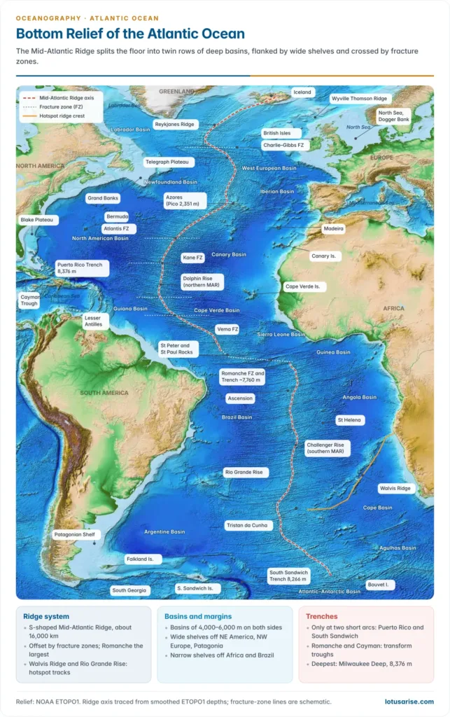
- The Mid-Atlantic Ridge (MAR) is the dominant feature of the floor, a submarine mountain range about 16,000 km long that occupies the central third of the basin.
- It runs from the Arctic, where it joins the Gakkel Ridge, through Iceland, to the Bouvet Triple Junction (about 54°S), where it meets the Southwest Indian Ridge and the American–Antarctic Ridge.
- It follows the S-curve of the coasts, staying roughly equidistant from both shores.
- Form:
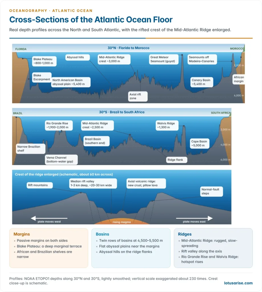
- up to about 1,600 km wide in the north and about 1,000 km in the South Atlantic, rising 2–3 km above the basins, with the crest mostly less than 2,700 m below sea level;
- a median rift valley 1–3 km deep runs along the crest for almost its whole length;
- rugged, block-faulted flanks, because it is a slow-spreading ridge (about 2.5 cm/yr).
- Discovery:
- Matthew Fontaine Maury inferred a mid-ocean rise from the soundings of the USS Dolphin (1853).
- The Challenger Expedition (1872–76) traced it into the South Atlantic.
- The Meteor Expedition (1925–27) mapped it by echo sounding.
- Marie Tharp and Bruce Heezen identified its central rift in the 1950s.
- In Project FAMOUS (1973–74) the submersibles Alvin, Archimède and Cyana dived into the rift near 36°50′N and found fresh pillow lava on its floor and fault scarps on its walls.
- Origin: early views blamed tension or compression in the crust. Sea-floor spreading settled the question.
- In 1966 James Heirtzler and colleagues found magnetic stripes mirrored on both flanks of the Reykjanes Ridge, confirming the Vine–Matthews idea first tested on the Carlsberg Ridge of the Indian Ocean.
- The ridge is a divergent (constructive) plate boundary: basalt rises, cools and is carried away on both sides, and its fracture zones are transform faults.
Named parts and transverse ridges
- The ridge carries classical regional names, and transverse ridges branch from it towards the continents, subdividing the basins.
| Part or branch | Where | Nature |
|---|---|---|
| Reykjanes Ridge | South-west of Iceland | Ridge crest raised by the Iceland hotspot |
| Telegraph Plateau | Between Ireland and Newfoundland | Broad, shallow part of the ridge; named after the first trans-Atlantic cable route (1858) |
| Wyville Thomson Ridge | Faroe Islands to Scotland (about 60°N) | Transverse sill, crest about 400 m deep; part of the Greenland–Scotland Ridge |
| Dolphin Rise | North Atlantic, north of the Equator | Classical name of the northern ridge |
| Challenger Rise | South Atlantic, south of the Equator | Classical name of the southern ridge |
| Azores Plateau | Around the Azores (about 38°N) | Volcanic plateau at the Azores triple junction |
| Sierra Leone Rise and Guinea Rise | Off West Africa | Transverse rises between the eastern basins |
| Walvis Ridge | Tristan da Cunha to Namibia (about 18°S) | Over 3,000 km long; hotspot track |
| Rio Grande Rise | Off southern Brazil (about 30°S) | Mirror image of the Walvis Ridge |
- Further transverse features close the northern basins: the Newfoundland Rise (a ridge of seamounts running south-east from the Grand Banks) and the Azores–Gibraltar Ridge, which links the Azores to the Strait of Gibraltar.
- The Azores–Gibraltar line is the boundary between the African and Eurasian plates. A great earthquake, probably on this boundary south-west of Portugal, destroyed Lisbon in 1755 and sent a tsunami across the Atlantic.
- The Greenland–Scotland Ridge (Denmark Strait sill, Iceland–Faroe Ridge, Wyville Thomson Ridge) dams the cold Arctic bottom water. Its overflows are a source of North Atlantic Deep Water, a limb of the ocean circulation.
- The Walvis Ridge and Rio Grande Rise are a V-shaped pair of hotspot tracks left by the Tristan–Gough hotspot, which erupted the Paraná–Etendeka flood basalts about 132 million years ago as the South Atlantic opened.
- Granitic rock dredged from the Rio Grande Rise in 2013 suggests it may hold a continental fragment. Brazil has claimed it as part of its extended continental shelf under UNCLOS (submitted 2018, not yet decided).
- These rises steer the Antarctic Bottom Water that floors the basins.
- It flows north from the Argentine Basin into the Brazil Basin through the Vema Channel, a gap about 4,650 m deep in the Rio Grande Rise.
- The Walvis Ridge blocks it from the eastern basins, which are renewed mainly through the Romanche and Chain fracture zones.
Fracture zones
- Transform faults offset the ridge into segments. Their fossil traces, fracture zones, run east–west across the basins.
| Fracture zone | Latitude | Notes |
|---|---|---|
| Charlie–Gibbs | About 52–53°N | Twin transforms offsetting the ridge by over 340 km |
| Oceanographer | About 35°N | South-west of the Azores |
| Atlantis | About 30°N | Beside the Atlantis Massif and Lost City vents |
| Kane | About 24°N | Offset about 160 km |
| Fifteen-Twenty and Vema | About 15°N and 11°N | Low-latitude transforms |
| Romanche | Equator | Largest offset, about 900 km; trough about 7,760 m deep |
| Falkland–Agulhas | About 45–50°S | Transform along which South America slid past southern Africa |
Activity on the ridge
- Iceland is the ridge above sea level. Its rift can be walked at Þingvellir, where the plates pull apart in open fissures.
- Nine fissure eruptions on the Reykjanes Peninsula (Sundhnúkur, December 2023 to August 2025) forced the evacuation of Grindavík, and magma was still accumulating in 2026.
- Surtsey, a new island built by a submarine eruption off the south coast in 1963–67, is now a UNESCO World Heritage Site.
- Hydrothermal fields dot the crest.
- The TAG field near 26°N has black smokers venting fluid above 350°C.
- The Lost City field (found in 2000 near 30°N) vents warm alkaline fluid from serpentinised mantle rock. In 2023 a drilling expedition cored about 1.2 km of mantle rock there, the longest such core yet.
- Polymetallic sulphides on the northern ridge are under International Seabed Authority exploration contracts held by Russia (2012), France (2014) and Poland (2018). India’s own sulphide contract lies on the ridges of the Indian Ocean.
- A 2021 seismic study beneath the equatorial ridge found signs of upwelling from the mantle transition zone (410–660 km deep), so the ridge may be more than a passive crack filled by shallow melt.
Basins, Deeps, Islands and Seas
Basins east and west of the ridge
- The ridge splits the floor into a western and an eastern trough, each 3,700–5,500 m deep. Transverse ridges and rises divide these into basins floored by abyssal plains.
- Western basins are generally deeper and larger, and receive the sediment of the big American rivers.
- North American Basin, between about 12°N and 40°N, is the largest. Turbidites from the American margin spread its flat Sohm, Hatteras and Nares abyssal plains, and the Bermuda Rise swells from its centre.
- Brazil Basin lies between the Equator and about 30°S, closed to the south by the Rio Grande Rise; the Argentine Basin beyond it reaches about 6,000 m.
- On the east, the Angola Basin runs from the Gulf of Guinea to the knot where the Walvis Ridge meets the main ridge, broad near Africa and narrowing south-west.
- Seamounts and guyots rise from the basin floors. The Great Meteor Seamount (about 30°N, 28.6°W), found by the Meteor in 1938, is a guyot that rises about 4,500 m from the floor to within 270 m of the surface.
- The New England Seamounts, a chain running south-east from the Gulf of Maine, track an old hotspot across the North American Basin.
| Western basins (north → south) | Depth and notes | Eastern basins (north → south) | Depth and notes |
|---|---|---|---|
| Labrador | About 3,500–4,000 m | West European | About 4,000–4,800 m; Porcupine and Biscay plains |
| Newfoundland | About 4,500 m | Iberian | Over 5,000 m |
| North American | Largest; over 5,000 m; Sohm, Hatteras and Nares plains, Bermuda Rise | Canary | Over 5,000 m; Madeira Plain |
| Guiana | About 4,500–5,000 m | Cape Verde | 5,000–6,000 m |
| Brazil | Over 5,000 m | Sierra Leone, Guinea | About 4,500–5,000 m |
| Argentine | 5,000–6,000 m | Angola | Over 5,000 m |
| Atlantic–Antarctic (Weddell) | About 5,000 m | Cape, Agulhas | About 4,000–5,000 m |
Deeps and trenches
- Trenches are few, because the Atlantic has no young fold mountains along its coasts. Its margins are passive. The deepest points lie at two short subduction arcs and in transform troughs.
- Early surveys named many “deeps”, by convention hollows deeper than about 5,500 m (3,000 fathoms), such as the Nares and Hatteras deeps. Most are simply the lowest parts of basin floors, not trenches.
| Deep or trench | Location | Maximum depth | Origin |
|---|---|---|---|
| Puerto Rico Trench (Milwaukee Deep) | North of Puerto Rico | 8,376 m | Oblique subduction of the North American plate beneath the Caribbean plate |
| South Sandwich Trench (Meteor Deep) | East of the South Sandwich Islands | 8,266 m (7,434 m at the Factorian Deep, south of 60°S) | South American plate subducting beneath the South Sandwich plate; about 965 km long |
| Romanche Trench | Equator, 16–20°W | About 7,760 m | Transform trough cutting the ridge |
| Cayman Trough | Between Jamaica and the Cayman Islands | 7,686 m | Pull-apart basin with a short spreading centre; black smokers near 5,000 m |
- The Milwaukee Deep is named after the cruiser USS Milwaukee, which sounded it in 1939. Victor Vescovo made the first crewed descent on 21 December 2018.
- The Lesser Antilles and South Sandwich Islands are the volcanic island arcs above these two subduction zones, small counterparts of the arc-and-trench belts that ring the Pacific and the Sunda arc of the Indian Ocean.
- The South Sandwich arc is the eastern end of the Scotia Arc, a loop of ridges and islands (South Georgia, South Orkneys, South Shetlands) that joins the Andes to the Antarctic Peninsula around the Scotia Sea.
Islands
- The Atlantic has fewer islands than the Pacific, and they fall into groups by origin:
| Type | Origin | Examples |
|---|---|---|
| Continental | Parts of the shelf, joined to the mainland at Pleistocene low sea levels | British Isles, Newfoundland, Falklands; South Georgia (a continental sliver in the Scotia Arc) |
| Ridge volcanic | Peaks of the ridge crest | Iceland, Azores (Mount Pico, 2,351 m), Ascension, Tristan da Cunha, Gough, Bouvet |
| Mantle uplift | Mantle rock pushed up along a transform | St Peter and St Paul Rocks |
| Intraplate volcanic | Hotspot volcanoes on older crust | Canaries, Madeira, Cape Verde, St Helena, Trindade, Fernando de Noronha; Bermuda (coral cap) |
| Island arcs | Subduction | Lesser Antilles, South Sandwich Islands |
- The volcanic islands are still active.
- Tristan da Cunha erupted in 1961, forcing the evacuation of its whole population.
- On La Palma (Canaries) the Cumbre Vieja eruption of September–December 2021 lasted 85 days and destroyed thousands of buildings.
- Bermuda is a coral cap on an old, subsided volcano, an Atlantic example of the growth of coral reefs on sinking foundations.
Marginal seas
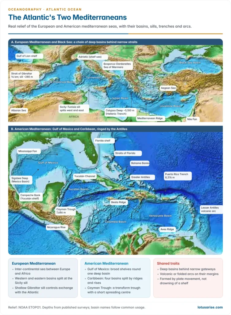
- Marginal seas crowd the North Atlantic and are almost absent from the South Atlantic. European seas formed by drowning of the continental margin; the American Mediterranean (Caribbean and Gulf of Mexico) is tectonic.
| Sea | Type | Relief |
|---|---|---|
| Mediterranean | Inter-continental | Strait of Gibraltar about 14 km wide; Sicily–Tunisia sill splits western and eastern basins; Calypso Deep about 5,100 m |
| Black Sea | Inland, via Bosporus | Deep, anoxic basin |
| North Sea, Baltic | Shelf seas | Mostly under 100 m; Baltic brackish |
| Caribbean | Tectonic | Yucatán, Cayman, Colombia and Venezuela basins; Cayman Trough 7,686 m |
| Gulf of Mexico | Tectonic, broad shelf | Sigsbee Deep about 3,750–4,384 m (estimates differ) |
| Hudson Bay, Baffin Bay, Labrador Sea | Glaciated margins | Hudson Bay shallow; Baffin Bay and Labrador Sea deep basins |
- The Mediterranean is a chain of basins rather than one hollow.
- The western basin holds the Alboran Sea, the Algero-Provençal Basin and the Tyrrhenian Sea.
- The eastern basin holds the Ionian and Levantine basins, with the Adriatic and Aegean as arms; its deepest point, the Calypso Deep (5,109 m measured in 2020), lies in the Hellenic Trench, where Africa is subducting beneath the Aegean.
- The Camarinal Sill at Gibraltar is only about 280 m deep. Atlantic water flows in at the surface and salty Mediterranean water spills out beneath it, one of the key water masses of the North Atlantic.
- The Black Sea drains through the Bosporus, Sea of Marmara and Dardanelles. Fresher water flows out at the surface; below about 150–200 m it is anoxic.
- The Caribbean is bounded by the Greater Antilles (Cuba, Hispaniola, Jamaica, Puerto Rico) to the north and the arc of the Lesser Antilles to the east. The Beata Ridge and Nicaragua Rise divide its floor into basins over 4,000 m deep.
- The Gulf of Mexico is a simple basin ringed by wide shelves (Campeche Bank, the Florida and Texas shelves). It opens to the Caribbean through the Yucatán Channel (up to about 2,780 m deep) and to the Atlantic through the Straits of Florida, the gateway of the Gulf Stream.
- Hudson Bay and the Baltic are shallow basins pressed down by Pleistocene ice and still rising by glacial rebound.
- The Mediterranean nearly dried out in the Messinian salinity crisis (about 5.96–5.3 million years ago), when the Gibraltar gateway closed, and refilled in the Zanclean flood.
Origin and Significance of the Atlantic
Opening of the basin
- The Atlantic is a product of sea-floor spreading at the ridge, a divergent boundary in plate tectonics that pushes the American plates west and the Eurasian and African plates east.
- Its S-shape, parallel coasts, symmetrical magnetic stripes and crust that grows older towards both margins all record this.
- An earlier ocean, Iapetus, opened in the late Precambrian and closed in the Palaeozoic to raise the Caledonian–Appalachian mountains. John Tuzo Wilson (1966) used this closing and reopening to frame the Wilson cycle.
- The present Atlantic opened in stages during the break-up of Pangaea:
| Segment | Opening | Notes |
|---|---|---|
| Central Atlantic | About 200–175 million years ago (Late Triassic–Early Jurassic) | North America separates from north-west Africa |
| South Atlantic | From about 135–130 million years ago, opening northward | Africa and South America part; Tristan hotspot active |
| Equatorial Atlantic | About 120–100 million years ago | Last link between Brazil and West Africa breaks |
| North Atlantic and Labrador Sea | About 60–55 million years ago | Greenland separates; Iceland plume |
- Some rift arms failed as the continents parted. The Benue Trough of Nigeria is the classic example, a failed arm (aulacogen) of the South Atlantic rift that now guides the Benue river.
- While the young South Atlantic was a narrow, evaporating gulf, thick salt settled on its floor. Spreading split it, so Brazil’s Santos and Campos basins and Angola’s Kwanza Basin are mirror-image salt basins.
- The ocean is still widening, by about 2.5 cm a year on average.
- The Atlantic may already be starting to close. It is being consumed at the Lesser Antilles and Scotia arcs, and a 2024 modelling study suggests the Gibraltar subduction zone could invade the Atlantic in about 20 million years.
Significance of the Atlantic floor
- Coastal types: Eduard Suess contrasted Atlantic-type coasts, cutting across the grain of the land, with Pacific-type coasts parallel to young fold mountains; passive margins explain the broad shelves and scarce trenches.
- Hydrocarbons: thick sediment on the passive margins makes them rich petroleum provinces.
- Proven areas include the North Sea, the Gulf of Mexico and Brazil’s pre-salt fields (Tupi, 2006).
- Newer finds lie off Guyana (Liza, 2015) and in Namibia’s Orange Basin (Graff and Venus, 2022).
- ONGC Videsh, India’s overseas oil company, holds a 27% stake (since 2013) in the BC-10 deep-water block of Brazil’s Campos Basin.
- Fisheries: the broad, cool shelves of the North Atlantic and the Patagonian Shelf are among the richest fishing grounds.
- Cables: the shallow Telegraph Plateau carried the first trans-Atlantic cable (1858); turbidity currents down canyons remain a major natural hazard to cables.
- Circulation: the Greenland–Scotland sills, Gibraltar and the Vema Channel regulate deep-water exchange, so the relief helps steer the overturning circulation.
| Feature | Atlantic | Pacific | Indian |
|---|---|---|---|
| Shape | S-shaped, elongated | Roughly triangular, widest | Bounded on three sides by land |
| Margins | Mostly passive | Ringed by active margins | Mostly passive; active only at the Sunda arc |
| Mid-ocean ridge | Central, slow-spreading, rifted | East Pacific Rise, off-centre, fast-spreading | Inverted-Y system |
| Trenches | Few (Puerto Rico, South Sandwich) | Many, the deepest on Earth | Mainly the Sunda (Java) Trench |
| Shelves | Widest share of floor | Narrow on the east, broad on the west | Broad off western India and north-west Australia; narrow off East Africa |
| Marginal seas | Many in the north, almost none in the south | Many along the west | Few |
Previous Year Questions
2010Explain the scientifically sound methods of bathymetry and give an account of the bottom topography of the Atlantic Ocean.2004Discuss the mid-Atlantic Ridge in terms of its origin, extent and relief.1998Explain and illustrate the submarine relief of the Atlantic Ocean.1996Explain and illustrate the ocean floor topography and give a detailed account of the Mid-Atlantic Ridge.