

- Urban Morphology is the study of the form, structure, layout, and internal spatial organisation of cities — including the arrangement of streets, buildings, land-use zones, open spaces, and infrastructure — and the historical, social, economic, and physical processes that have produced them over time. It is the “biography” of a city written in bricks, lanes, and land use.
- Urban morphology studies the physical layout of a city (streets, blocks, plots, buildings) and its functional organization (CBD, industrial zones, residential areas).
- It reveals the historical accretion of a city — how layers of development from different historical eras are superimposed upon each other in a single urban area.
- It is closely linked with urban land use models (Burgess, Hoyt, Harris-Ullman) that seek to explain and predict the internal structure of cities.
- For Indian cities specifically, urban morphology is shaped by four distinct historical phases: ancient, medieval, colonial, and post-independence — each leaving a distinctive imprint on the cityscape.
Urban Morphology of Indian Cities

- A large number of cities in India have a long history of evolution. As a consequence, their nucleus and the old part of the city are characterised by elements of natural growth, which are recognised as indigenous parts of the cities.
- During the British period, a new anglicised part was added to the existing town with a large number of government offices, cantonment, civil lines, railway colonies, etc.
- Later, during the post-independence period, newly developed areas were added, which were built up according to modern style, architecture, and plan.
- Thus, a single town or city may exhibit characteristic morphological features reflecting its development during different historical phases.
- Generally, the urban morphology of cities in India shows a dual structure. It is either blending indigenous features and Western-style structure or hybridised European features. Kolkata is similar to a Western city functionally, but it is more compact than any of the Western European cities of the same population.
- Allahabad was and is still densely populated to the south, nearer the Jamuna River. It is unplanned to have a maze of narrow streets in complete contrast to the Civil Lines, which is established on an extensive grid plan. The railway area acts as an effective divide blocking access to the north. It completely shuts off the crowded and irregular city from the broadly planned rectangular cantonment and civil lines.
- The impact on the morphology of cities in India is purely social. Society in the 19th century had a distinctive character and organisation of its own. Thus, the morphology or forms of the towns in India reflect faithfully ethnic and social distinctions. The social areas of Third World cities are basically characterized by the degree of modernisation, and consequently, there is visible in the urban landscape patches of both ‘traditional’ and ‘modern’ areas.
- In most of the cities in India, a dual structure is found, and their morphological pattern may conveniently be divided into ‘local’ and ‘foreign’ lineaments. The old city of Delhi, for example, was a walled city with a moat. The walls and moat have now given way to post-independence development. But the ‘remains’ in the form of residential and commercial areas reflect the high density of buildings, irregular pattern of streets flanked by narrow lanes, and uncontrolled growth of mixed land use.
- The residential units of the indigenous city, mainly the ‘Chandni Chowk’ and ‘Sadar Bazar area’ are deeply ingrained by caste and community quarters. Outside the old city, and, beyond the Daryaganj area, there lies a spacious area of European-style buildings with a core in Connaught Place. It is further extended including the Parliament area of European-style bungalows, modern shops, and offices, the Central Business Circular Area with modern departmental stores and supermarkets.
- The entire facade represents the British legacy. If someone closely examines the morphology of Indian cities, it would not be a surprise for him to find that over one city, another of the entirely different urban scene is being superimposed. Besides a mixed land use, a new type of layout is being grafted along with an indigenous one.
- After several decades of the country’s freedom and alienation, the most ubiquitous factor is a continuation of the Western way of urbanism in political, economic, cultural, and social life in urban centers of India. These influences are subtle in medium-sized towns but dramatic in metro cities.
- Most of the cities that were formerly under the princely states’ rule had a wall indicating the need for protection. The wall is now being demolished to make way for new business markets flanked on both sides by spacious roads and multi-storied buildings used as offices, financial and commercial establishments, and even for residential purposes in some cases.
- “With the change in the concept of security, the city wall appears to be an anachronism. In Jodhpur, in view of the futility, it is now being demolished at various places to give way to roads and to provide more space for shopping centers.”
- The same is the case in Udaipur where the city wall is now being demolished for the development of the central business area where banks, financial institutions, and retail stores find sites in buildings erected on both sides of the roads radiating east, north, and westward from the gates of the demolished wall.
Classification of Indian Cities by History of Origin
The internal structure of Indian cities is best understood through their history of origin and development. Each historical period imposed a distinct morphological character that persists in the urban landscape today.
1. Ancient Cities (Pre-Medieval)
- Cities of the Indus Valley Civilization (Mohenjo-daro, Harappa, Dholavira) showed the world’s earliest known urban planning — a grid-iron street layout, with main streets running north-south and east-west, dividing the city into rectangular blocks.
- Each block had uniform housing, a covered drainage system, public granaries, and a citadel mound — demonstrating both democratic equality and hierarchical governance in spatial form.
- In the Vedic period, town plans followed a “rectangular layout oriented to the four quarters”, with two intersecting avenues terminating in four gateways, and the centre occupied by a temple, palace, tank, or garden.
- Ancient surviving cities are characterized by: organic, winding lanes (galis); temple or ghat as the morphological anchor; mixed residential-commercial land use; and extremely dense building fabric with minimal open space.
- Examples: Varanasi (Kashi) — one of the world’s oldest continuously inhabited cities; Kanchipuram — ancient Pallava capital with temple-tank-centred morphology; Patna (Pataliputra) — Mauryan capital on Gangetic terrace; Madurai — temple town with concentric street rings (mada streets) around the Meenakshi temple.
- Ancient Indian cities were not organized by economic rent alone (as Western models assume) but by ritual hierarchy and caste occupation. Brahmin quarters surrounded the temple; artisan castes (potters, weavers, blacksmiths) occupied specific lanes near their work; lower castes were spatially marginalized to the city’s periphery.
- This caste-based spatial segregation (reflected in the Jajmani system) is a uniquely Indian morphological feature that Western models entirely fail to capture, and it persists — in modified form — in the mohalla structure of old Indian city cores today.
2. Medieval Cities (Sultanate & Mughal Periods, ~1200–1750 AD)
- Medieval cities are characterized by the fort-mosque-bazar trinity as the morphological core — the ruler’s fort or palace at the highest point, the congregational mosque adjacent to it, and the market (bazar) spreading outward from the fort gate.
- The city was typically walled (indicating the need for military protection), with entry through monumental gateways (darwaza).
- Inside the walls, the city was organized by mohallas — self-contained residential quarters defined by caste, craft, religion, or ethnic community — with a central mosque or temple and a small market (katra or sarai).
- Streets were narrow, winding, and organic — designed for pedestrian movement and not for wheeled traffic or formal planning.
- Meena bazaars, sarais (roadside inns), hammams, and dargahs were important morphological features of the Mughal city.
- Examples: Shahjahanabad (Old Delhi) — built by Shah Jahan (1648) with the Red Fort at its apex, the Jama Masjid at its heart, and Chandni Chowk as its commercial spine; Agra — with the Agra Fort, Taj Mahal (slightly removed), and the city’s organic expansion around the bazaars; Lucknow — with the Imambara complex, Rumi Darwaza, and Hazratganj as morphological layers from different periods; Ahmedabad — walled city with intricate pol (neighbourhood) system.
3. Colonial Cities (British Period, ~1750–1947)
- The British fundamentally transformed Indian urban morphology by superimposing a planned Western urban layer upon existing indigenous city fabric — creating the characteristic dual structure of Indian cities.
- Colonial morphological additions included: Civil Lines (planned residential areas for British officers, wide roads, bungalows with large compounds); Cantonments (military quarters, rigidly planned on grid, physically separated from “native city”); Railway colonies (around the railway station, housing rail workers); Government quarters (colonial administrative buildings — secretariat, high court, collector’s office, with grandiose European architecture).
- Colonial planning patterns:
- Spider-web / Concentric pattern: Delhi (Lutyens’ New Delhi), Canberra — settlements developed in concentric circles around a planned centre.
- Rectangular / Grid-iron pattern: Industrial towns — Tata Nagar (Jamshedpur), parts of Chennai (George Town), Kolkata’s central planned area.
- Radial pattern: Mumbai — roads radiating from fort/port area outward.
- The colonial city was characterized by racial and class segregation — the “white town” (civil lines, cantonment) was separated from the “black town” (native city) by a deliberate physical and social buffer zone.
- Examples: Mumbai — grew from seven islands into a unified port city; Kolkata — Dalhousie Square as colonial administrative core, with native city (north Kolkata) clearly demarcated; Chennai — George Town (native) vs. Egmore and Nungambakkam (colonial); Shimla — built entirely as a colonial hill station capital.
4. Modern / Post-Independence Cities (Post-1947)
- Post-independence India saw the development of planned cities built from scratch on rational, modernist principles — Chandigarh, Bhubaneswar, Gandhinagar, Dispur, Bokaro, Naya Raipur.
- These cities are based on rectangular or grid patterns, with designated sectors or zones for residential, commercial, industrial, and institutional use — the principles of the CIAM (Congrès Internationaux d’Architecture Moderne).
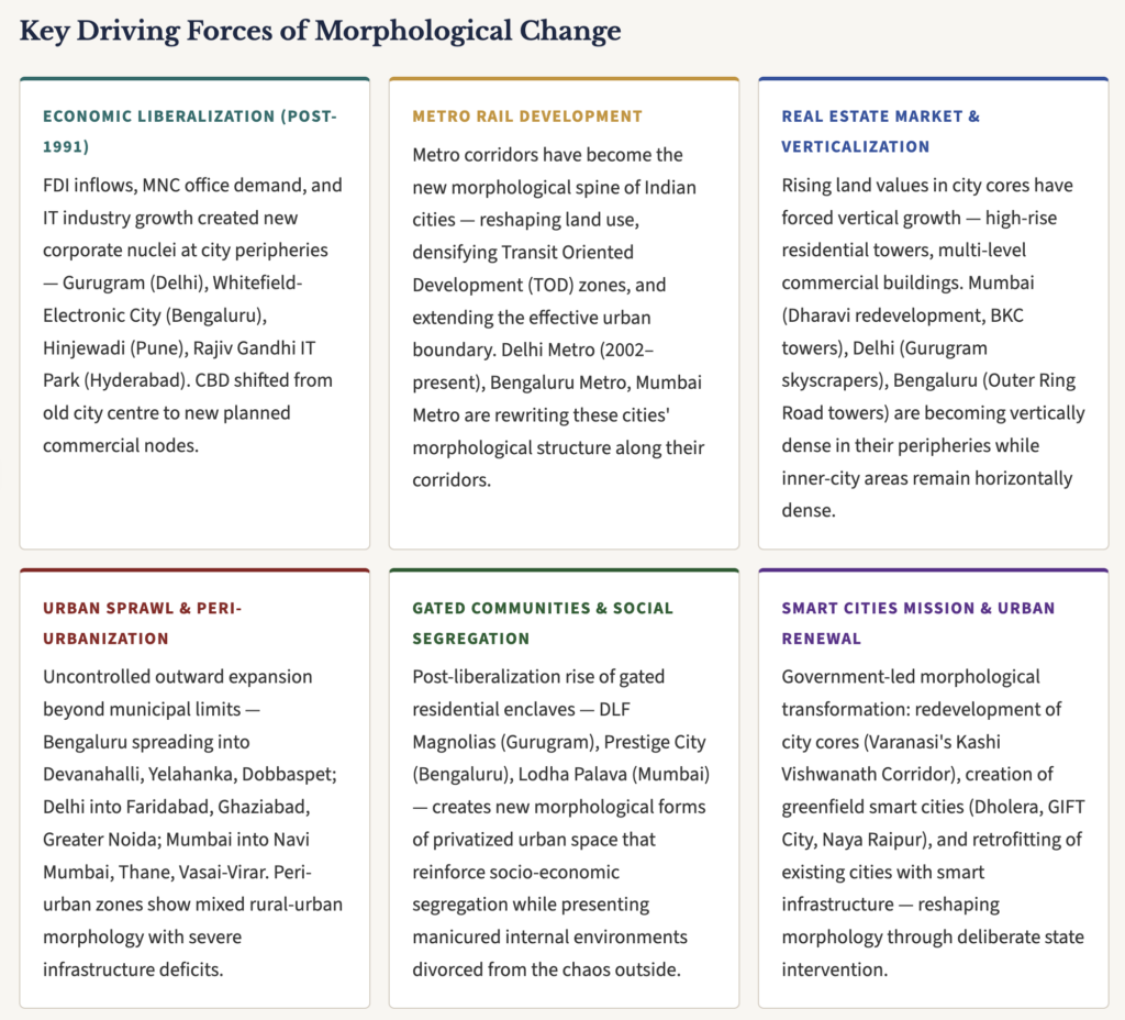
- Post-1991 economic liberalization created a new morphological layer in existing cities: Special Economic Zones (SEZs), IT parks, malls, gated communities, Metro Rail corridors, and Airport cities — creating new nuclei at the urban periphery.
- Examples: Chandigarh (Le Corbusier’s grid-sector design); Gandhinagar (Gujarat — capital planned on Chandigarh lines); Naya Raipur (Chhattisgarh — new capital under Smart Cities initiative); GIFT City (Gujarat — India’s first greenfield financial centre).
| Period | Morphological Character | Key Features | Indian Examples |
|---|---|---|---|
| Ancient | Organic / Temple-centred | Winding lanes, ghat/temple nucleus, caste mohallas, mixed land use | Varanasi, Kanchipuram, Patna, Madurai |
| Medieval (Mughal) | Fort-Mosque-Bazar Trinity | Walled city, darwaza, mohalla system, meena bazar, dargah, sarai | Shahjahanabad, Agra, Lucknow, Ahmedabad |
| Colonial (British) | Dual / Superimposed grid | Civil lines, cantonment, railway colony, racial segregation, grid + radial patterns | Mumbai, Kolkata, Chennai, New Delhi, Shimla |
| Post-Independence | Planned / Multi-nuclei | Sector-based planned cities, IT parks, SEZs, gated communities, Metro corridors | Chandigarh, Gandhinagar, Noida, GIFT City |
Internal structure of Indian cities
- Internal structure can be understood by classificatory approach because Indian cities not only have various level of development but also history of origin.
- Structure of Indian cities based on history of origin:
- Ancient Cities – Varanasi, Kanchipuram, Gaya etc.
- Medieval Cities – Delhi, Agra, Ahmadabad, Allahabad, Shahjanabad, etc.
- Modern Cities – Noida, Chandigarh, Vishakhapatnam (these cities have been developed on the lines of British administrative requirements and have places such as Ghanta Ghar, Civil Lines, Cantonment)
- Structure of Indian cities based on level of development
- Unplanned City – Patna, Banaras
- Quasi-Planned – Delhi, Kolkata, Lucknow, Mumbai, Bangalore
- Planned – Chandigarh, Noida, Jaipur.
Colonial principles of planning
- Spider web pattern: Delhi and Canberra are the examples of this form of planning. The settlements are developed in concentric forms.
- Rectangular pattern: This type of pattern is found in industrial towns such as Tata Nagar, Chennai, Kolkata, etc. The planned part of these cities has rectangular pattern.
- Radial Pattern: Mumbai is the example of this type of planning where city has developed along the coast in radial pattern.
- Semi circular pattern: This type of planning can be seen in West Patna, Kochi, and Meerut etc.
- Organic Morphology: Here the topography of site becomes important in the development of roads in hill towns and plateau towns. E.g. Melbourne, Hill stations, etc.
The Dual Urban Structure — The Defining Feature of Indian Cities
- The most distinctive morphological characteristic of Indian cities is their dual urban structure: the coexistence, within a single city boundary, of:
- The Indigenous / Old City
- Organically grown ancient or medieval core — narrow winding lanes (galis), dense building fabric, temple/mosque/dargah as focal points, mohalla-based social organization, mixed residential-commercial land use, traditional architecture, poor drainage and infrastructure.
- The Colonial / Modern Extension
- Planned British or post-independence addition — wide roads, grid or radial layout, Civil Lines, cantonment, government quarters, railway colony, or modern planned colony with segregated land use zones and better civic infrastructure.
- The Indigenous / Old City
As geographers have observed: “If someone closely examines the morphology of Indian cities, it would not be a surprise to find that over one city, another of an entirely different urban scene is being superimposed. Besides a mixed land use, a new type of layout is being grafted along with an indigenous one.”
- The dual structure is most dramatic in metropolitan cities (Delhi, Kolkata, Lucknow, Hyderabad) but is visible at varying degrees in medium and small cities too.
- Old city areas (Chandni Chowk, Lucknow’s Chowk, Hyderabad’s Charminar area) retain their original morphology with remarkable persistence — despite massive population growth — because of the high cost of redevelopment, the social and cultural attachment of communities, and the political complexity of urban renewal.
- The contrast between old and new city is a key diagnostic feature examiners expect candidates to articulate with specific examples in UPSC answers.
- Post-1991 liberalization has added a third layer: the globalized city — with glass towers, malls, gated communities, and IT parks that are morphologically indistinguishable from cities in Singapore or Chicago — creating a triple urban structure in India’s largest metros.
Internal Zones of a Typical Indian City
While no single Indian city fits any one model perfectly, the following internal zones can be identified as characteristic features of most large Indian cities, synthesizing the insights of all three models:
Zone I — The Old City Core (Pre-Colonial Nucleus)
- Temple, mosque, fort, or ghat as the morphological anchor.
- Narrow, winding, organic lanes (galis) — designed for pedestrian movement, impassable by motor vehicles in many cases.
- Mixed land use — ground floor commercial (small shops, workshops), upper floors residential. No segregation of functions.
- Mohalla system — self-contained community quarters defined by caste or craft (the potters’ lane, the weavers’ quarter, the goldsmiths’ street).
- Dense multi-storeyed buildings with minimal setback, poor natural light and ventilation.
- Congregation of same-trade shops in the same lane — cloth market, brass market, utensil market, book market — a distinctive feature of Indian bazaar morphology.
- Tendency of shops to spill onto the lane, further narrowing traffic flow.
- Old to new houses coexist in the same lane — some centuries-old havelis, some modern concrete structures.
- Poor drainage, irregular water supply, and congested infrastructure are common challenges.
Zone II — The Transitional Zone (Inner Periphery)
- Contains light manufacturing industries — handicrafts, bidi-making, lock-making, printing presses.
- Weavers’ housing (as in Varanasi), artisan workshops, and small-scale production units.
- Roads are narrow and congested; infrastructure slightly better than Zone I.
- Presence of slums and informal settlements as the zone deteriorates from Zone I.
- Wholesale markets for bulk trade in agricultural commodities and manufactured goods.
Zone III — Working-Class Residential
- Greater social cohesion within communities — this is the “utopian socialist” zone of Indian cities where class differentiation is less evident and community bonds are stronger.
- Self-built housing (pucca and semi-pucca structures) improved over time through gradual investment.
- Local markets, schools, and places of worship at walkable distance.
- Often organized around a community well, park, or religious building.
Zone IV — Middle-Class Planned Colonies
- Post-independence planned residential colonies — laid out on grid or sector pattern by Development Authorities (DDA, BDA, HMDA etc.).
- Better road width, parks, schools, hospitals, and civic amenities.
- High-rise apartments and cooperative housing societies coexist with individual bungalows.
- Examples: Delhi’s Rohini, Dwarka, Pitampura; Bengaluru’s Jayanagar, Rajajinagar; Mumbai’s Bandra, Powai (modern extensions).
Zone V — Outer Fringe / Peri-Urban Zone
- The most rapidly changing zone — contains institutional areas (university campuses, hospitals, government offices), heavy industries, airports, IT parks, and new township developments.
- Also contains squatter settlements as rural migrants first settle in the most affordable peripheral land.
- The rural-urban fringe — a dynamic zone where urban and rural land uses interpenetrate.
- Upper-class gated communities and luxury townships (DLF City, Prestige City, Sobha City) are increasingly the dominant morphological feature of this zone in post-liberalization India.
Significant works have been done by geographers like Garrison, Kusum Lata, John E. Bush, and Prof. Ashok Dutta on the morphology of Indian cities.
Garrison (American) work:
- It is known as “Fused growth theory on Urban Morphology”.
- It has emerged as model work for the study of modern metro cities of South Asia in particular. E.g. Jakarta.
- According to him there are three important trends:
- Up to 1990 there has been concentric growth of towns.
- From 1900 to 1950, there has been sectoral growth because of growth of transportation.
- After 1950, there is multi-nuclei growth.
- The case study of Varanasi and Calcutta is in agreement with the Garrison’s model.
- Garrison’s model has been criticised for being a model of large sized towns and not for all towns.
Mrs. Kusum Lata’s Classification
- Planned Towns
- Designed with a deliberate spatial layout — rectangular or grid pattern for streets and zones. Sectors clearly demarcated for residential, commercial, institutional, and industrial functions.
- Examples: Chandigarh (Le Corbusier’s sector grid), Gandhinagar (Gujarat — similar to Chandigarh), Noida, Jaipur (old walled city — planned by Maharaja Jai Singh II on Vastu Shastra principles in 1727).
- Jaipur’s old city is a rare example of a planned indigenous city — its grid layout, colour scheme (pink), and proportional streets were all designed, not organic.
- Unplanned Towns
- Characterized by disorganized, organic growth driven by: historical and genetic factors, rural-to-urban migration, transformation of villages into towns, and infrastructure built after the settlement established. No prior layout plan. Morphology reflects accretion over time.
- Examples: Most older Indian cities — old Varanasi, Agra’s city core, Meerut’s old quarters, Jodhpur’s organic old city.
- Narrow winding lanes, irregular plots, mixed land use, no building setbacks.
- Planned-cum-Unplanned Towns
- The most common type in India — a single city contains both a planned zone (colonial civil lines, cantonment, or modern colony) and an unplanned indigenous zone (old city core). The two zones exist within the same municipal boundary but with starkly contrasting morphological character.
- Examples: Delhi (Shahjahanabad = unplanned + New Delhi = planned), Lucknow (Chowk = unplanned + Hazratganj = colonial planned), Hyderabad (old city around Charminar = unplanned + Banjara Hills = planned modern), Jaipur (old walled city = planned indigenous + Civil Lines = British addition = modern Malviya Nagar = post-independence planned).
Professor Ashok Dutta’s Work:
- The study of Professor Ashok Dutta was based on two aspects: Nature of CBD and Residential Segregation.
- In Western cities, the CBD is a purely commercial zone with no residential use. In Indian cities, the CBD tends to have a significant residential component — families live above their shops; traditional merchants prefer to live near their businesses.
- Only 4 CBDs – Mumbai, Delhi, Kolkata and Chennai have similar CBDs, where, in the daytime there is high activity, while at night they are deserted.
- In most other Indian towns CBD is not an exclusive market zone rather it is also characterised by high population density.
- Indian CBDs are weaker in functional concentration — not a single dominant downtown but multiple commercial nodes spread across the old city bazaar, the British-era shopping street, and new commercial centres.
- Due to multinucleated development, Indian cities lack a monocentral concentration of commercial activity — the CBD is a “weak centre” compared to Chicago, London, or New York.
- Excessive congestion, high population density, and the social norm of living near one’s workplace obstruct the emergence of a purely commercial CBD in Indian cities.
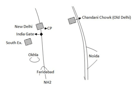
- There is a tendency of Indian society to live in the CBD. E.g. Delhi is the case study of a medieval and quasi-planned town. There are 2 nucleione is pre-industrial nucleus (Chandani Chowk) and other is modern nucleus modern nucleus).
- Multiple nuclei model can be applied in Delhi. Delhi has lately seen the emergence of further new CBDs e.g. South Extension (VII), Heavy manufacturing (VI) – Okhla, Nangoli, and Residential Suburbs (VIII) – Sonipat, TDICD, DLF City, etc.
Case study of Banaras (Ancient City)
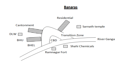
- It represents the ancient and unplanned structure of Indian cities. It is considered the best Indian example of the Burgess Concentric Zone Model, while also illustrating the unique features of ancient Hindu urban form that Western models fail to capture.
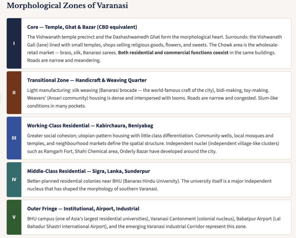
- Central Business District
- It consists of a temple and wholesale retail market.
- It has places for both residential and commercial purposes. The roads are narrow and meandering roads with poor drainage system
- It has tendency of congregation of shops in an area/road. E.g. brass, cloth market, utensils etc.
- The lanes are the area with high economic activity.
- Transition zone
- It consists of light manufacturing industries and weavers housings.
- Handicraft, bidi making industries can be found in this region
- Roads are narrow and congested.
- Middle class housing
- This is the area with greater social cohesion. There is no class differentiation.
- There is utopian residential housing with socialist pattern
- The out fringe has development of institutional areas, heavy industries, air port, educational areas etc.
- Independent nucleation
- There are independent nucleated settlements that has developed around city such as Ramgarh fort, Shahi Chemical, Sarnath temple, Diesel Locomotive Works.
Case study of Kolkata
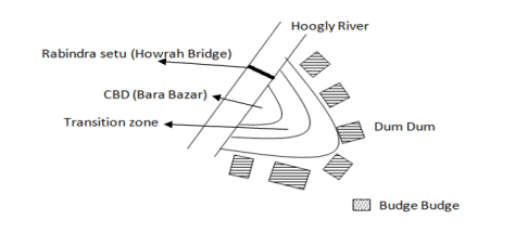
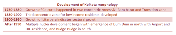
- Along the Hooghly riverside, east of Howrah Bridge, a large metro city of Calcutta emerged with the rise of Europeans. It emerged from 1750.
- From 1750 to 1850, the growth of the town is in two concentric zones. Bara Bazaar area emerged as the nucleus, CBD.
- The CBD is surrounded by a zone of transition. This is the zone where all kinds of functions are done such as residence, marketing, godown, social centers, etc.
- The third concentric zone emerged to accommodate low-income group
- Post-1990, due to the sectoral growth, areas of functional specialization emerged. Mainly for industrial and residential functions.
- After 1950, the independent nucleation of urban settlements around the main city (e.g. Dum Dum) emerged as HIG residences and airports. Budge Budge emerged in south. (this model applies to religious and historical cities as well)
Delhi — A Multi-Period, Multi-Nuclei City
- Delhi is the supreme Indian example of morphological complexity — it is simultaneously an ancient, medieval, colonial, and modern city, with each era’s morphological layer still visible in the contemporary cityscape. It is a quasi-planned, multi-nuclei city to which the Harris-Ullman Multiple Nuclei Model most closely applies.
Delhi’s Multiple Nuclei
| Nucleus | Character | Historical Period |
|---|---|---|
| Qutub Minar area / Mehrauli | First city of Delhi — pre-Mughal medieval nucleus | Delhi Sultanate (~1200 AD) |
| Red Fort / Chandni Chowk (Shahjahanabad) | Mughal commercial and residential core — old city with walled morphology | Mughal period (1648 AD) |
| Connaught Place (CP) | British-planned CBD — radial layout, colonnaded shops, planned open space | Colonial period (1931 AD) |
| Nehru Place / South Extension | Post-independence commercial CBD — IT, electronics wholesale, offices | Post-1960s |
| Okhla / Nangoli Industrial Estate | Heavy manufacturing and industrial nucleus | Post-independence |
| Rohini / Dwarka | Planned residential suburbs by DDA — middle-class colonization of periphery | 1980s–2000s |
| Gurugram (DLF City, Cyber City) | IT/corporate new nucleus — post-liberalization, luxury gated communities | Post-1991 |
| Noida / Greater Noida | Satellite city nucleus — residential + IT + industrial | Post-1976, boom post-2000 |
- Delhi’s morphology is further characterized by its seven historical cities — Qila Rai Pithora, Siri, Tughlaqabad, Jahanpanah, Firozabad, Purana Qila, and Shahjahanabad — whose ruins are embedded in the contemporary urban fabric, making Delhi one of the world’s most archaeologically layered cities.
Colonial Urban Morphology — The Bazaar-Based and Port-Based Models
Understanding Indian urban morphology requires going beyond Western models. Two non-Western morphological models are particularly relevant to the Indian context:
1. The Bazaar-Based (Indigenous) Morphological Model
- Reflects the organic, pre-colonial Indian city — built around the bazaar as the social, economic, and morphological centre.
- The bazaar is not merely a market but a multi-functional social space — where commerce, worship, social interaction, and residential life all overlap.
- Morphological characteristics:
- Temple or mosque at the highest or most central point
- Market (bazaar) radiating from the temple/mosque gate
- Craft and trade organized by mohalla — each community in its designated lane
- Haveli (large courtyard house) of wealthy merchants defines the elite residential morphology
- Public spaces (chauk, kund, ghat) serve as community focal points
- The bazaar-based model contains both rich and poor in close spatial proximity — wealthy traditional families (zamindars, traders) and artisan communities live in the same neighbourhoods, creating a social complexity absent in the class-segregated Western model.
2. The Port-Based (Colonial) Morphological Model
- Reflects the colonial port city — Mumbai, Kolkata, Chennai, Pondicherry — built by European powers (British, French, Portuguese) as trading posts, forts, and administrative centres.
- Evolution: trading factory → fortified centre (with ammunition dumps, barracks, defensive walls) → expanding administrative city (civil lines, churches, courts) → industrial port city.
- Morphological characteristics:
- Fort or factory at the seafront as the original nucleus
- White Town (European quarter) vs. Black Town (native quarter) — physically and socially segregated
- Civil Lines and Railway Colonies as planned residential extensions
- Broad planned avenues, maidans, and government buildings in the European quarter
- Dense, organic native city behind and around the European core
- Port infrastructure (docks, warehouses, rail freight yards) dominating the waterfront
- Examples: Kolkata — Fort William + Dalhousie Square (White Town) vs. North Kolkata (Black Town); Mumbai — Fort area (British core) vs. Dharavi and the mill districts (working-class native city); Chennai — Fort St. George + George Town (native) + Egmore/Nungambakkam (European extension).
Changing Urban Morphology of Million-Plus Cities — Post-Liberalization Forces
The New CBD Phenomenon in Indian Cities
- In all major Indian cities, new CBD formations have emerged outside the traditional city core, driven by: better connectivity, lower land costs (initially), planned infrastructure, and proximity to IT/corporate campuses.
- Delhi: Connaught Place (old CBD) → Nehru Place → Cyber City Gurugram → Aerocity (around IGI Airport)
- Bengaluru: MG Road (old CBD) → Outer Ring Road → Electronic City → Whitefield → Namma Metro TOD zones
- Mumbai: Fort Area (old CBD) → Nariman Point → Bandra-Kurla Complex (BKC) → Navi Mumbai (planned new centre)
- Hyderabad: Charminar area (old CBD) → Begumpet → Hi-Tech City (HITEC City) → Financial District → Pharma City (Genome Valley)
Conclusion
The morphology of Indian cities is not merely a planning subject — it is a living archive of the subcontinent’s civilizational history. Every narrow gali of Varanasi, every Mughal arch in Shahjahanabad, every colonial bungalow in Civil Lines, and every glass tower in Cyber City Gurugram is a morphological sentence in an urban story that spans five thousand years.
What makes Indian urban morphology uniquely complex — and uniquely important — is precisely this layering. Unlike cities that were destroyed and rebuilt (European cities after World War II) or built from scratch (American cities), Indian cities are geological in their structure: each era’s layer compresses below the next without disappearing. The result is cities of extraordinary depth, contradiction, and vitality.







Tnq sir ji…
USEFUL
Well organised content…. Thanks 🙂
thank you very much sir very heplful notes
thanku sir ……..
Please add other cities case study too if possible. Last year Delhi was asked.
In Kolkata case study and Garrison’s work – 1900 should replace 1990, please check if I’m wrong
From where have you find these diagrams of case study of banaras & kolkata…please tell its source..btw thank you for your efforts & hard work. These are really helpful notes.
Please add patna also
I think its Ashok Mitra, not Ashok Dutta.
Thank you so much 😊……best content
Kindly request…. please update all other
notes 😍