

- Indian crops differ widely with the availability of water, and much of the country has no assured irrigation.
- Rainfed agriculture is cultivation that depends on monsoon rainfall, without irrigation.
- It runs across many soils and agro-climates, under rainfall from about 400 mm to 1,600 mm a year.
- Dry farming is its driest form, practised mainly in the arid and semi-arid west and rain-shadow interior.
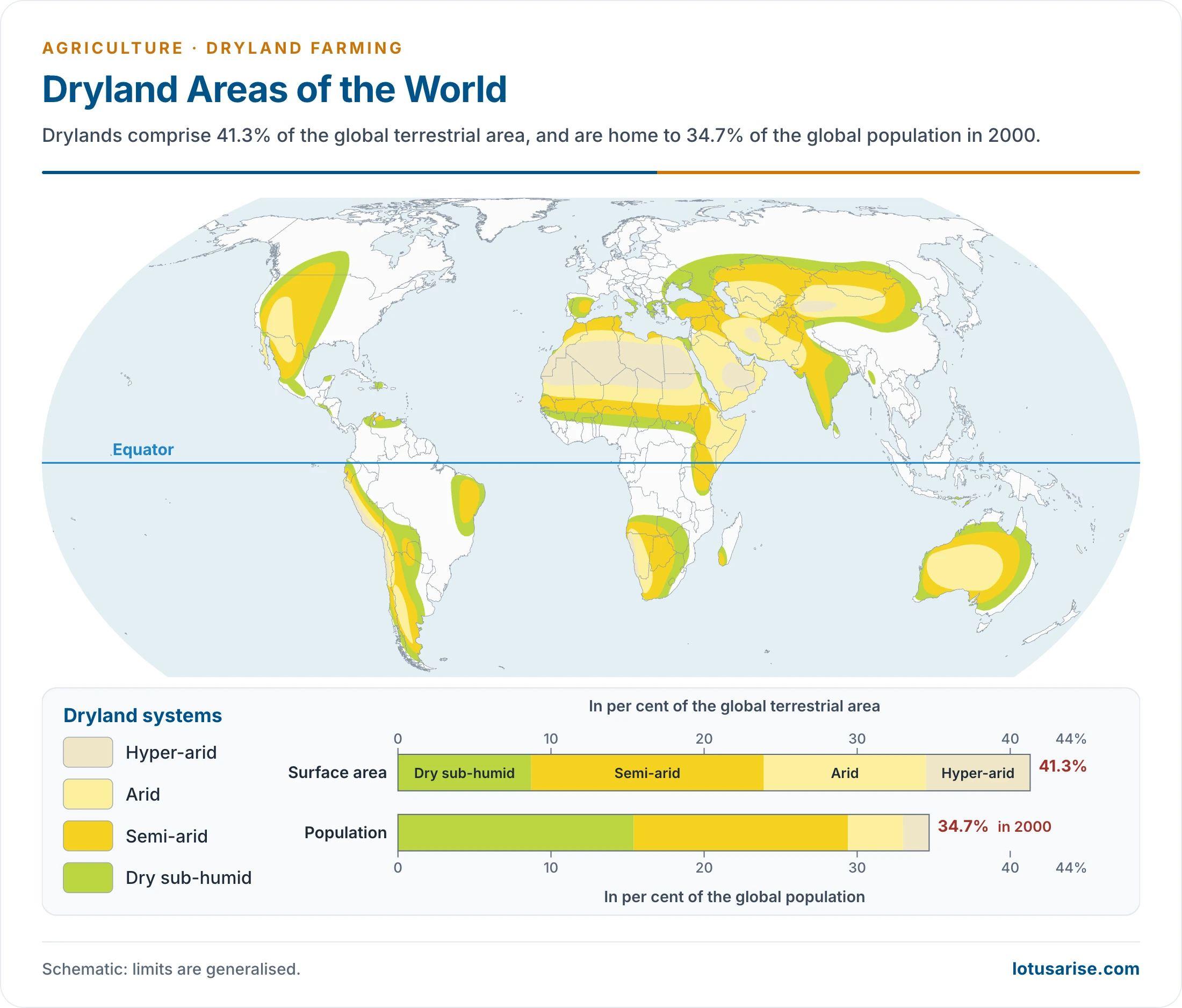
- This map shows dryland systems of the world, not farmland as such. Drylands cover 41.3% of the earth’s land and held 34.7% of its people in 2000.
Concepts and Extent
Rainfed, Dryland and Dry Farming
- A simple split is two-way: dry lands below 750 mm of rain a year, and rainfed areas above 750 mm.
- The agronomic classification is three-way:
| Feature | Dry farming | Dryland farming | Rainfed farming |
|---|---|---|---|
| Annual rainfall | Below 750 mm | Above 750 mm | Above 1,150 mm |
| Growing season | Below 75 days | 75–120 days | Above 120 days |
| Moisture stress | Crop failure common | Failure less frequent, despite dry spells | Crops rarely stressed |
| Key need | Moisture conservation | Moisture conservation | Drainage of excess water |
| Regions | Arid and semi-arid, e.g. Rajasthan | Semi-arid to sub-humid | Humid and sub-humid, e.g. Bihar |
| Cropping | Single crop or intercropping | Intercropping | Intercropping or double cropping |
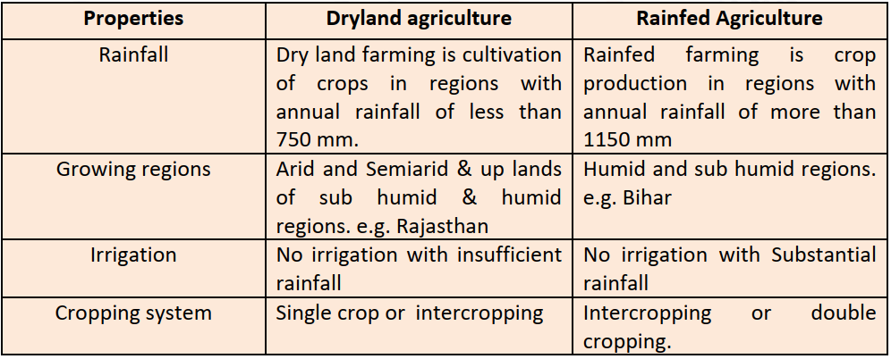
- In this table, the “dryland” column has the rainfall of dry farming.

- All three exclude irrigation. All dryland farming counts as rainfed, but not all rainfed farming counts as dryland. The difference lies in agro-ecology and cropping pattern.
- Dryland agriculture is the farming of sub-humid to arid tracts, with:
- Poor hydrology and few irrigation facilities.
- Complete dependence on the monsoon.
- A typical crop mix of coarse grains, millets, oilseeds, pulses and cotton.
Extent in India
- Older reckoning:
- India had 143 million hectares under cropping, of which 113 million hectares could be irrigated, leaving 30 million hectares rainfed even with all potential used.
- With 93 million hectares irrigated (100 million by a later count), about 43 million hectares stayed rainfed.
- Revised picture:
- The ultimate irrigation potential has been reassessed at about 139 million hectares, mainly through minor irrigation.
- Current figures (2023-24, provisional):
- Net sown area is 138.99 million hectares.
- Net irrigated area is 82.42 million hectares, or 59.30% of net sown area, up from 17.56% in 1950-51.
- So about 56.57 million hectares, or 40.7%, of net sown area has no irrigation, and only part of the rest is secure.
- Policy papers have long used higher shares: about 60% of net sown area around 2012, and about 51–52% more recently.
- Dry farming proper was estimated at 31.7 million hectares, about 22% of agricultural land.
- A long-quoted estimate puts two-thirds of the country under sub-humid or arid conditions and one-third humid, so dry farming spreads over more land than wet farming.
Dry Farming Belt
- The 75 cm isohyet marks its eastern edge.
- It runs from Kashmir to Kanniyakumari, broken briefly in Himachal Pradesh and around Jammu.
- Why this belt is dry:
- The Bay of Bengal branch of the monsoon is nearly spent by the time it reaches western Uttar Pradesh, Haryana, Punjab and Rajasthan.
- Ladakh, largely beyond the monsoon, is a cold desert.
- South of the Tapi, the plateau lies in the rain shadow of the Western Ghats.
- Area covered:
- All of Rajasthan, Punjab and Haryana.
- Much of Gujarat, western Madhya Pradesh and Uttar Pradesh.
- Vidarbha and Marathwada.
- Eastern Karnataka plateau, Rayalaseema and Telangana.
- Much of interior Tamil Nadu.
- Crop concentration (1990): the Central, Western and Southern Plateaus held 86.3% of jowar area and 87% of its output. Cotton (92% of area) and oilseeds (70%) also centre on the plateaus and Gujarat.
- Punjab, Haryana and western Uttar Pradesh fall in the belt by rainfall, yet canals and tube wells have changed their farming.
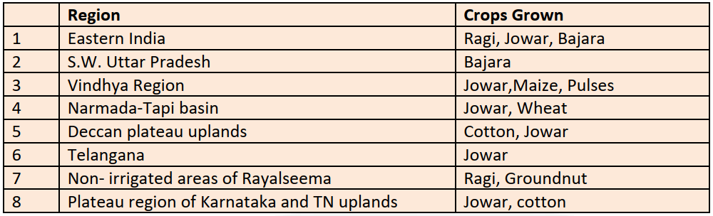
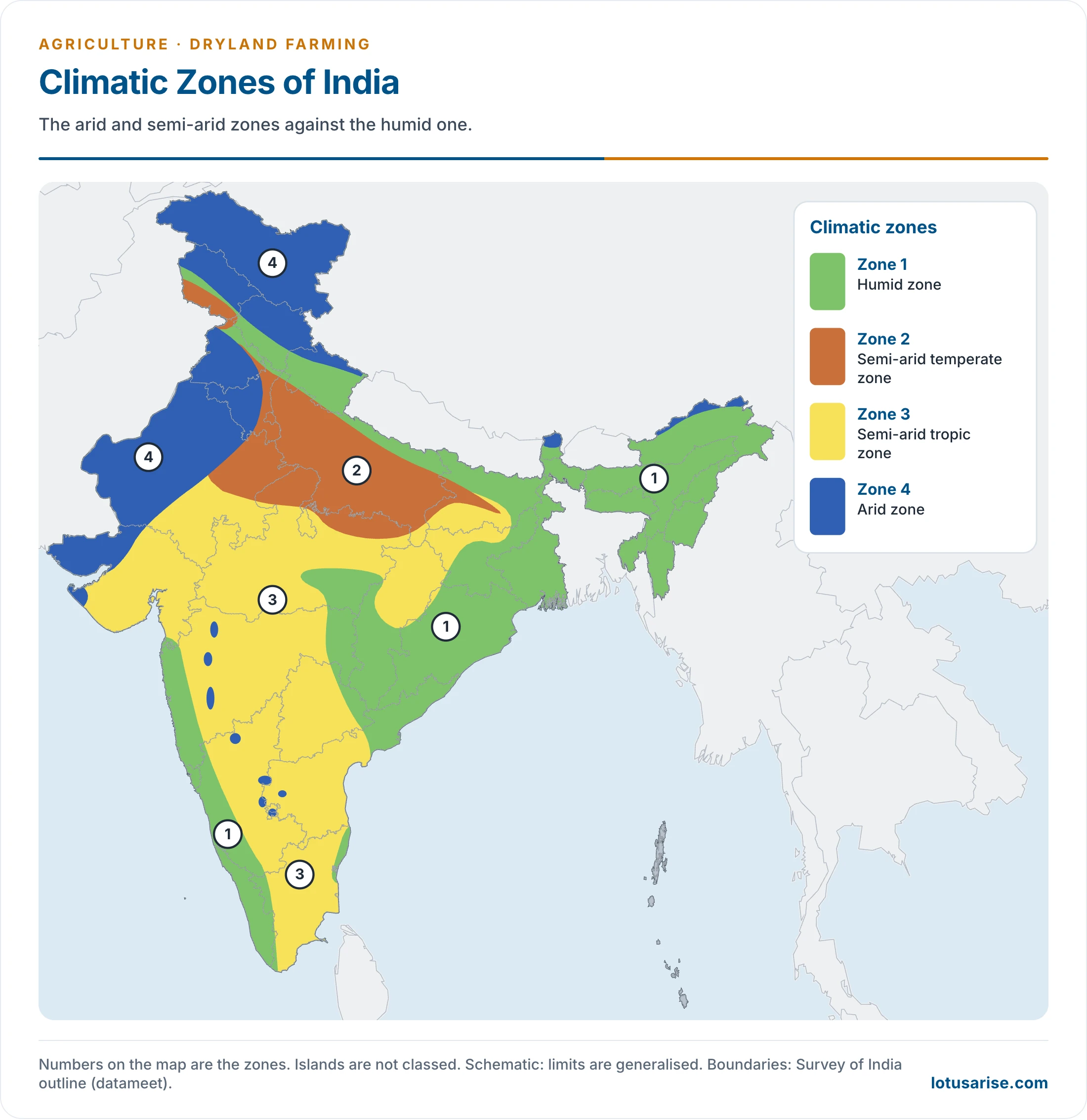
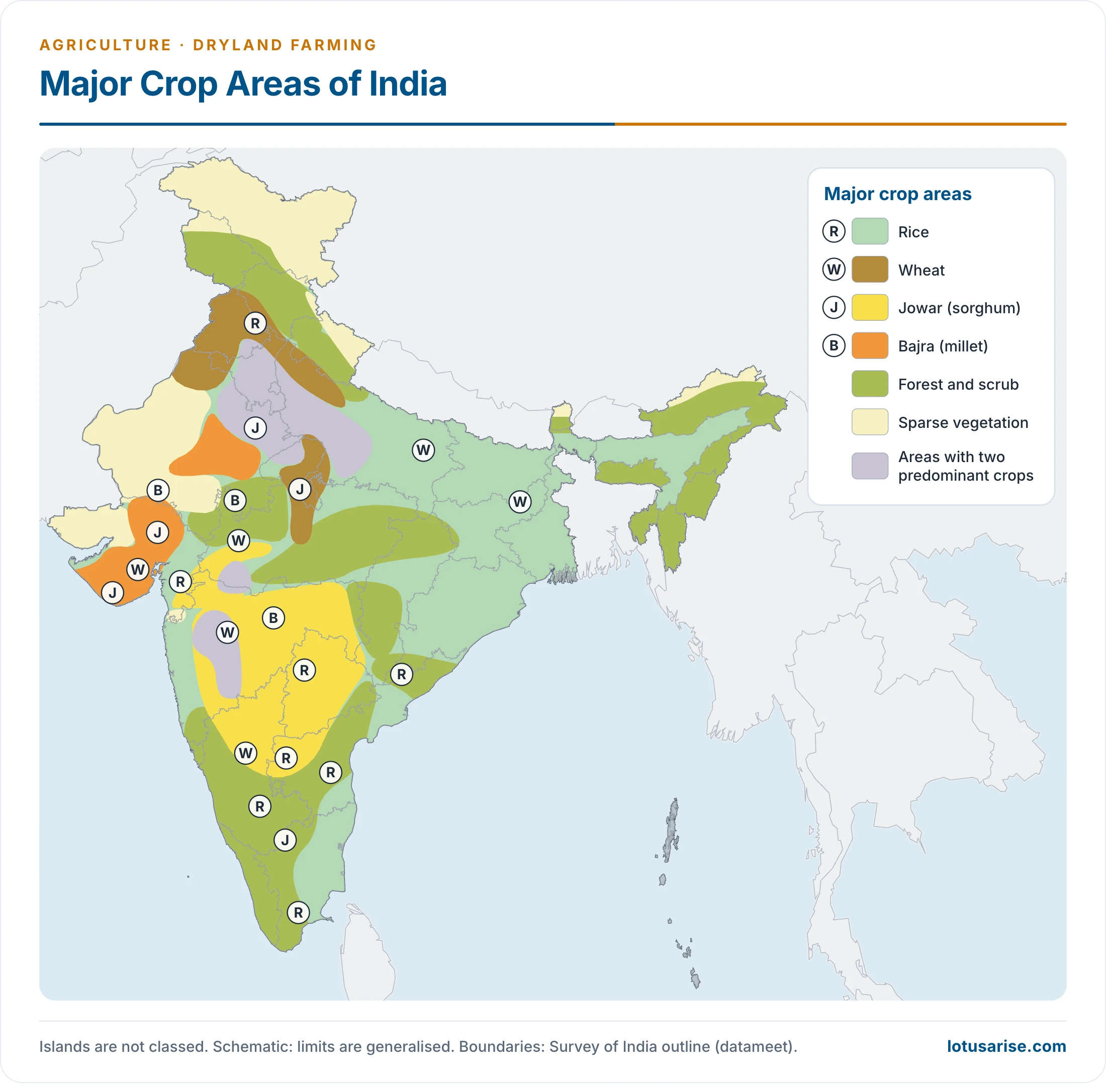
- Reading the maps:
- The zone map sets the arid and semi-arid zones against the humid one.
- The crop map shows jowar and bajra dominating the same dry interior, and rice and forest in the wetter east and along the coasts.
- Both are generalised maps, used for the pattern of zones and crops.
Salient Features
- Dry climate:
- Tracts near 70 cm are sub-humid, short of moisture for about 8 months.
- Areas of 25–50 cm are semi-arid, short of moisture all year.
- Jaisalmer and Barmer, below 25 cm, are completely dry.
- Rain falls in only 3–4 months, and its variability is 20–60%. Late onset, early retreat or a break in the monsoon can ruin a crop, and a drought can mean near-total failure.
- Lack of irrigation:
- Rajasthan has no major river of its own and much of its ground water is brackish. The Indira Gandhi Canal, drawn from the Satluj–Beas confluence, has changed crops and yields in the west.
- South India’s hard rocks hold little ground water and resist tube wells. Tanks are the chief source, and they fail in dry spells.
- Subsistence farming:
- Small and marginal farmers work with family labour and sell little.
- They cannot afford better seeds, fertilizers or machinery.
- Drought brings hunger and unemployment.
Why It Matters
Need for Dryland Agriculture
- Balanced development: these areas support about 40% of the people on about 66% of the land. Raising productivity here would correct that ratio.
- Dependence on farming: more than two-thirds of the population depend on it, against a national average then near 55%. Farming takes 65% of the area, and permanent pasture about 2.9%.
- Food and crop share (older estimate): about 40% of foodgrains, 85% of pulses, 75% of oilseeds, 80% of maize, and 95% of jowar and bajra.
- Area share (2012): rainfed land held 77% of pulse area, 66% of oilseed area and 45% of cereal area.
- Industrial crops: cotton, groundnut, oilseeds, pulses and tobacco feed agro-processing and make farming more export-oriented.
- Rural industry: farming has forward and backward linkages with industry. More industrial crops mean more meso-scale, household and cottage units, and so rural development, industrialisation and growth.
- Nutrition: hardy, nutritious crops such as jowar, bajra, ragi, pulses, oilseeds, cottonseed, sunflower and safflower can fight malnutrition in poor areas.
- Cash crops and fuel: jatropha oil can be blended with petroleum products, and it was backed to ease the petroleum crisis.
- Livestock:
- These lands can grow fodder and cattle feed, which supports the White Revolution.
- Pastures are more extensive, and cattle breeds here have a higher yield per head.
- Sheep-raising has better prospects in semi-arid areas.
- Imports: farmers have moved towards wheat and rice, which hurt pulses and oilseeds. India spends heavily on oilseed imports.
- Dryland technology can narrow the demand-supply gap in pulses and oilseeds and raise farmers’ incomes.
Problems
- Rainfall is scarce, erratic and unreliable, exposing the region to floods, droughts and famines.
- Sandy soils lack nutrients, and soils here are prone to erosion, particularly by wind.
- Yields are low, and crops are open to pests and diseases.
- High-yielding seeds and new technology are hard to use without moisture, so the Green Revolution largely passed these tracts by.
- Poverty keeps out costly inputs.
- Infrastructure is thin: markets, transport, storage and refrigeration. Farmers are pushed into distress sales.
- Farm distress:
- In 2023, 10,786 people in the farm sector died by suicide (4,690 farmers and 6,096 farm labourers), per the National Crime Records Bureau.
- Maharashtra (38.5%) and Karnataka (22.5%) recorded the largest shares.
- Deaths run higher in years of rainfall deficit. The cotton and soybean belts of Vidarbha and Marathwada, and rainfed northern Karnataka, are the usual examples.
- Monsoon risk, costly inputs, debt and thin markets combine here.
Improving Dryland Farming
Methods of Dry Farming
- Repeated ploughing, especially in the rains, so that the soil stores moisture.
- Fallowing, so that tired land recovers fertility.
- Pulverising the soil before sowing, so that water moves freely and roots spread.
- Hoeing, weeding and pruning at intervals:
- Hoeing lets air into the soil. Done before sunrise, it lets dew enter.
- Weeding removes competing plants.
- Pruning leaves more strength for the wanted parts.
- Straw cover (mulch) cuts evaporation and wind erosion.
- Allied work, such as livestock and dairying, supplements income.
Ways to Raise Efficiency and Productivity
- Water harvesting: capture rain where it falls, or catch the run-off in the village or town, and keep the catchment free of polluting activity. Ways to do it:
- Rooftop run-off.
- Local catchments.
- Seasonal floodwater from local streams.
- Watershed management.
- Moisture conservation in the field:
- Deep ploughing suits kharif crops, as rain can percolate into broken deep layers.
- Surface ploughing suits rabi crops, as it holds the moisture in.
- Contour bunds, embankments and small dams check run-off.
- Scientific agronomy: crop rotation and intercropping.
- Crop choice:
- Drought-resistant, high-yielding varieties and early-maturing crops. Improved seed of maize, wheat, barley and mustard, and of some pulses, does well here.
- Fit crops to moisture: rice in the low parts of tank and reservoir catchments, cotton where rain is dependable or sprinklers exist, sunflower and mustard where rain is scarce.
- Diversify, so that one failure is covered by another crop. Legumes grown with foodgrains also add nitrogen.
- Soil preparation:
- No soil is ideal, and continuous farming wears out fertility.
- Soil is therefore readied before sowing and after cultivation, in three steps: ploughing, levelling and manuring.
- Soil erosion control: tree rows as windbreaks, plantations to fix sand dunes, and ploughing along contours.
- Organic farming:
- Avoids synthetic pesticides, fertilizers and hormones.
- Relies on crop rotation, organic waste, farm manure, rock additives and crop residues.
- Cow dung and biological manures also spare poor farmers the cost of chemical fertilizers.
- Plant protection: weedicides and pesticides as needed, moving towards eco-friendly biological materials.
- Watershed management: conserving soil and water for lasting output with minimum non-point source pollution, by managing land surface and vegetation for farmers, community and society. Measures:
- Vegetative barriers.
- Contour bunds against erosion.
- Furrow and ridge cultivation across the slope.
- Drip and sprinkler irrigation management.
- Horticultural species on contour bunds.
- Ecological farming: methods, organic ones included, that rebuild ecosystem services:
- Services: erosion control, infiltration and water retention, carbon stored as humus, and biodiversity.
- Techniques: no-till, multispecies cover crops, strip cropping, terrace cultivation, shelterbelts and pasture cropping.
- Alternative land use: agro-forestry and legumes on large areas, and pastures and social forestry on marginal land and cultivable waste.
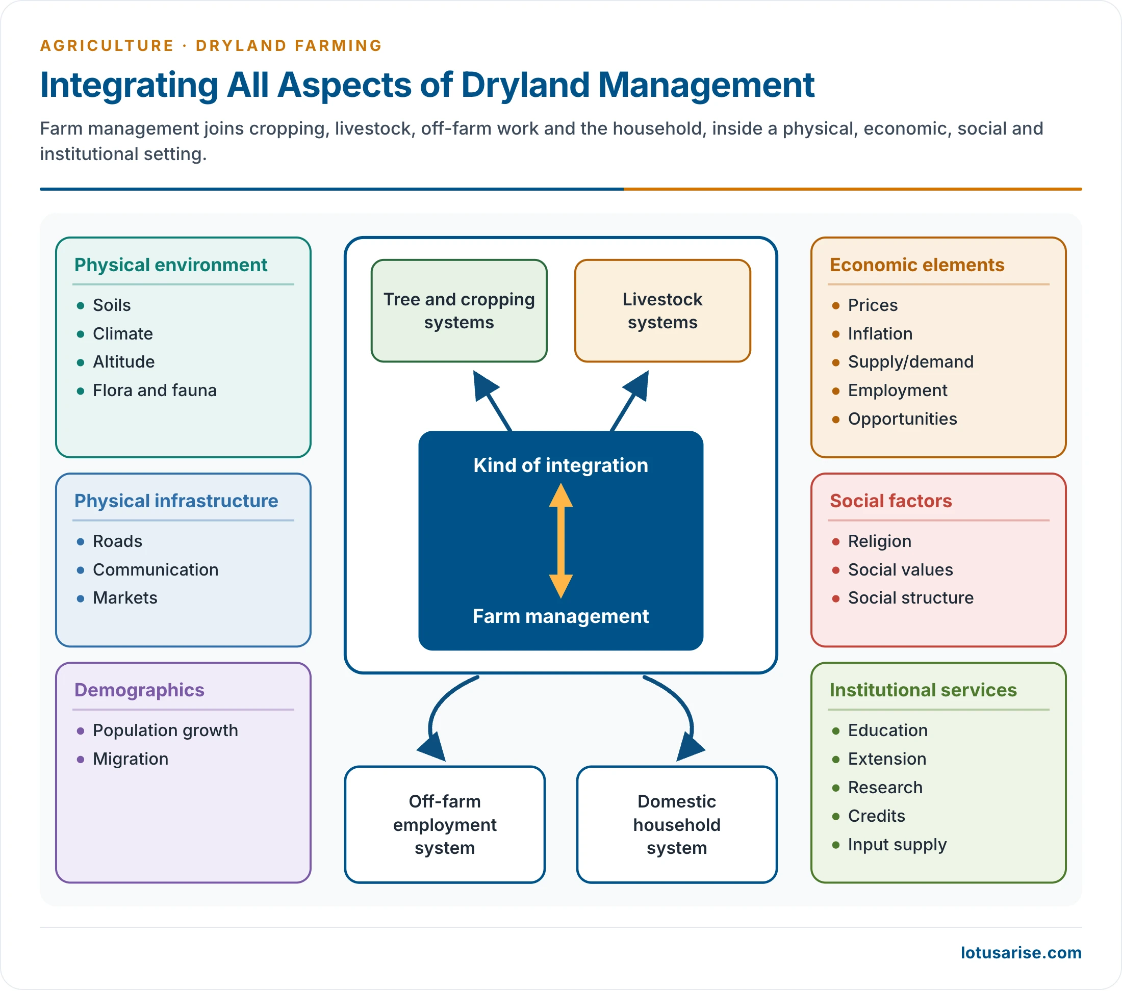
- The chart sets farm management inside its physical, economic, social and institutional setting.
Government Programmes
- Research:
- The All India Coordinated Research Project for Dryland Agriculture began in 1970, with 23 centres and Canadian help.
- Its Hyderabad centre became the Central Research Institute for Dryland Agriculture in April 1985.
- National Innovations in Climate Resilient Agriculture followed in 2011.
- Early programmes:
- Dry farming was part of the 20-point programme.
- 4,609 micro-watersheds of about 1,000 hectares each, covering some 35.45 lakh hectares, were identified, with 46 model watersheds as focal points. The work joined rainwater management, land development, drought-resistant seeds, tree planting and animal husbandry.
- A World Bank pilot covered watersheds of 25,000–30,000 hectares in Madhya Pradesh, Maharashtra, undivided Andhra Pradesh and Karnataka.
- A national watershed plan in the Seventh Plan took in 99 districts of 16 States.
- Crops needing less moisture (maize, sunflower, soybean, mustard, coarse grains) were promoted in rain-shadow Karnataka.
- Agro-forestry, agro-horticulture and silvipasture were started as alternative land uses.
- Area programmes: the Drought Prone Area Development Programme and the Desert Development Programme treat the driest tracts.
- National Rainfed Area Authority: an expert body set up in November 2006 to advise on dryland and rainfed farming.
- Pradhan Mantri Krishi Sinchayee Yojana:
- Its Watershed Development Component 2.0 runs for 2021-26.
- The target is 49.5 lakh hectares of rainfed and degraded land, at a central outlay of Rs 8,134 crore.
- Springshed rejuvenation has been added.
- National Mission for Sustainable Agriculture: its Rainfed Area Development work promotes integrated farming in these tracts.
- Details of watershed management decide how far these schemes reach the field.
Previous Year Questions
2022Discuss the importance of dryland farming in the drought-prone regions of India.2019Explain the significance of dry farming in drought-prone areas of India.2015With the help of a map, indicate the principal areas of dryland farming in the country and account for farmers’ suicides mainly in those areas.2006Discuss the problems and prospects of dry zone agriculture in India and highlight strategies and schemes for its development.2003Discuss the programmes and policy of development of dry areas in India.1995Write short note: Dryland farming.1992Explain the distribution and characteristics of dry zone agriculture.1986Give an account of the infrastructural factors necessary for promoting agricultural development in the dry zones of India with specific examples.





good
Government step to improve dry farming
Excellent illustration…
Excellent
Good