

- Volcanoes are among the most dangerous forces of nature. Their nature differs from one to another, and many eruptions release more energy than nuclear explosions.
- India’s only active volcano lies in the Andaman and Nicobar Islands: Barren Island. Researchers at the National Institute of Oceanography, Goa, reported that it began spewing ash again in 1991, after lying dormant for over 150 years.
- Elsewhere the country holds old and extinct volcanic rocks, from the Precambrian Malani suite to the Deccan Traps. Volcanic landforms built on these rocks are still visible today.
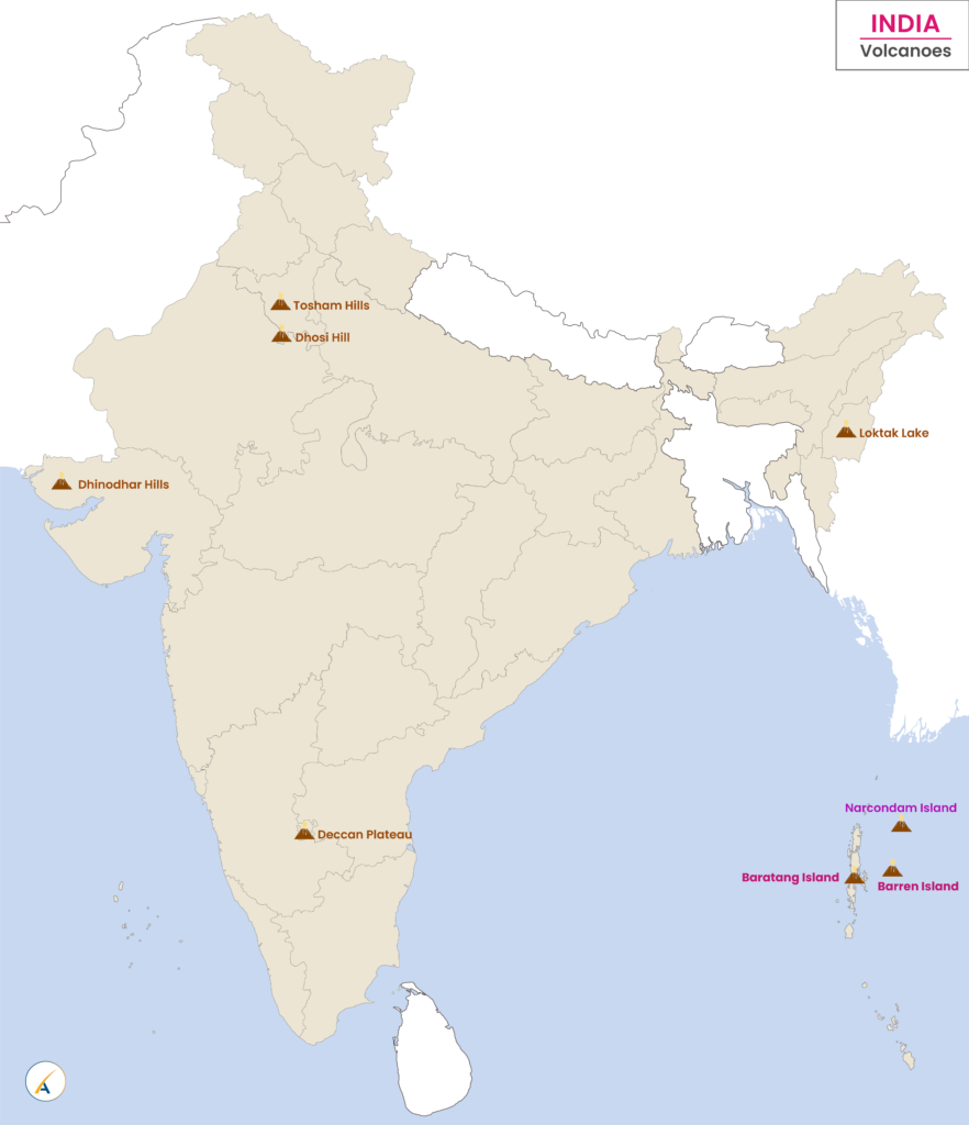
Volcanoes at a Glance
List of all Volcanoes in India
| Volcano | Place | Last activity or age | Type and status |
|---|---|---|---|
| Barren Island | Andaman Sea, Andaman and Nicobar Islands | Active; older lists “since 2017”; eruptions in 2025 | Stratovolcano, active |
| Narcondam | Andaman Sea, Andaman and Nicobar Islands | Older lists give 1681 | Stratovolcano, dormant (semi-dormant in older lists) |
| Deccan Plateau | West-central India | About 66.4–65.4 Ma (older lists 25 Ma BP) | Flood basalt province, extinct |
| Baratang Island | Andaman and Nicobar Islands | Active since 2003; eruption in October 2025 | Mud volcano |
| Dhinodhar Hills | Kachchh, Gujarat | Older lists 500 Ma BP | Volcanic plug, fully extinct |
| Dhosi Hill | Haryana–Rajasthan border | Older lists 750 Ma BP | Extinct |
| Tosham Hills | Bhiwani, Haryana | About 732 Ma BP | Fully extinct |
| Loktak Lake | Manipur | Older lists 100 Ma BP | Status unknown |
- Ma BP means million years before present.
Active, Dormant and Extinct
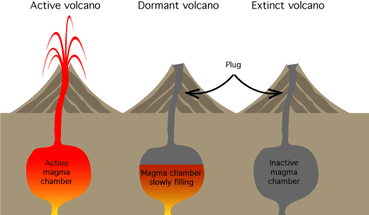
- Active volcano: erupting now or likely to erupt, with a live magma chamber below.
- Dormant volcano: no recent eruption, but its magma chamber is slowly filling, and a plug blocks the vent.
- Extinct volcano: inactive, with no supply of magma, and not expected to erupt again.
Volcanoes of the Islands
Barren Island
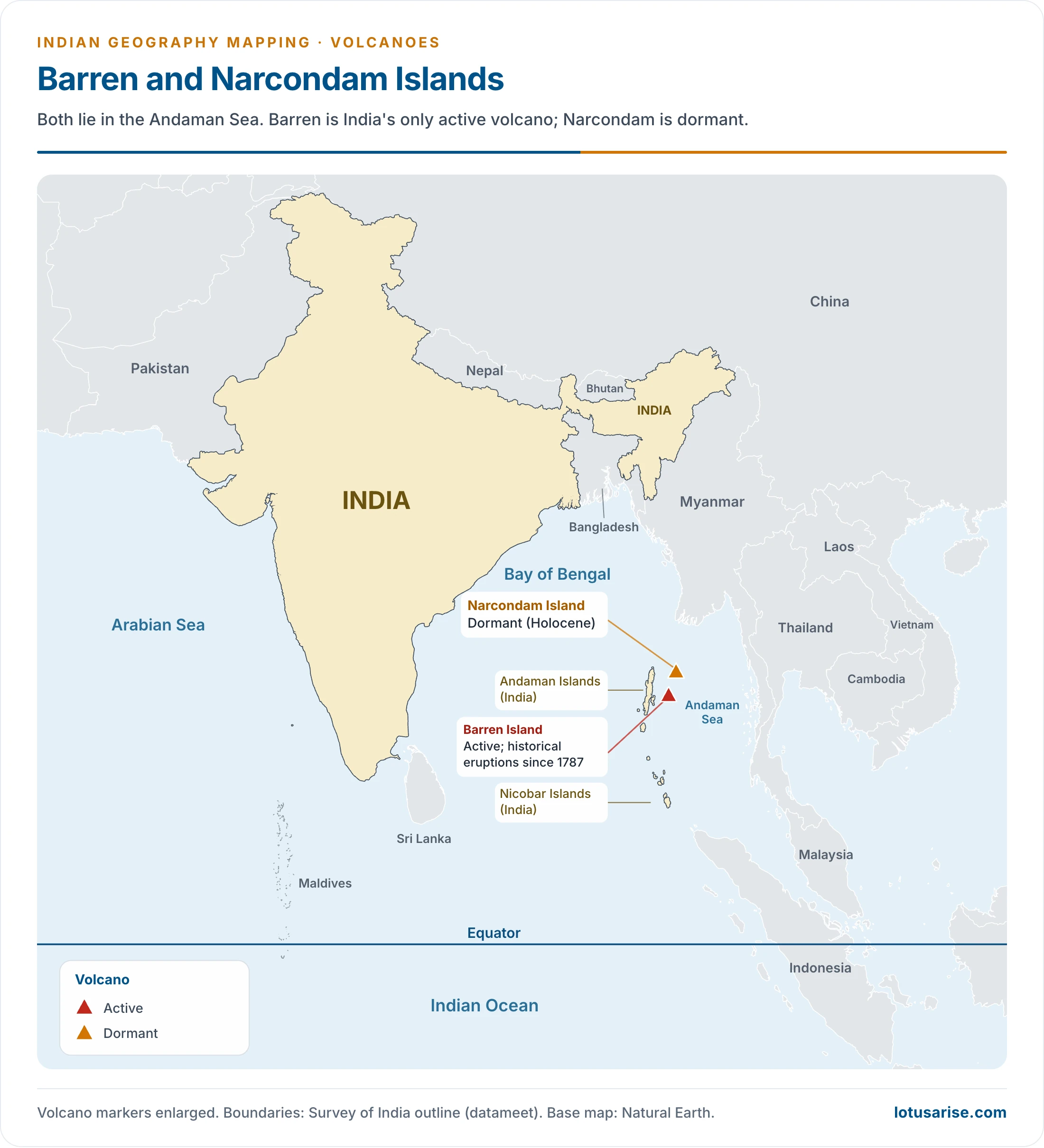
- Barren Island lies in the Andaman Sea, about 135 km north-east of Sri Vijaya Puram (Port Blair). It is dominated by Barren Volcano, the only confirmed active volcano in South Asia.
- It is the only active volcano along the chain of volcanoes from Sumatra to Myanmar.
- The record of eruptions:
- The first recorded eruption dates to 1787, followed by 1789, 1795, 1803–04 and 1852.
- After nearly one and a half centuries of quiet, it erupted in 1991 for about six months, and again from December 1994.
- Later episodes came in 2005–06 and in several years from 2015 to 2019, including 2017.
- Since January 2022 it has been in an almost constant state of eruption.
- It erupted mildly on 13 and 20 September 2025, and lava flows on its north flank ran from mid-November to December 2025.
Narcondam
- Narcondam is a small volcanic island in the Andaman Sea, and India’s easternmost island.
- Its peak rises to 710 m above mean sea level, and it is formed of andesite. The main body of the Andaman Islands lies about 124 km to the west.
- The Geological Survey of India treats it as a dormant volcano, of Holocene age. Older lists date its last activity to 1681.
- The name may come from the Tamil naraka-kundam, meaning “a pit of Hell”.
Baratang
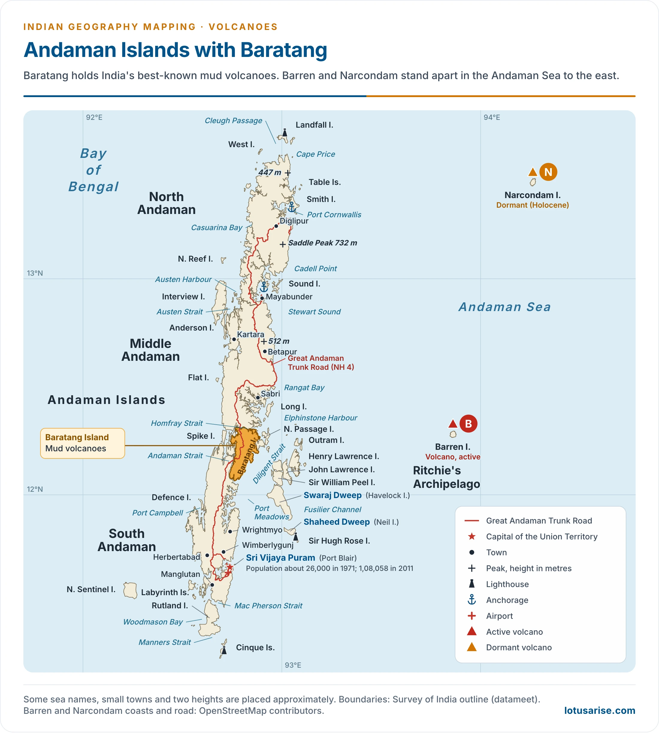
- Baratang Island is one of the Andaman Islands, in the North and Middle Andaman administrative district of the Union Territory. Ranchiwalas Island is another name for it.
- It holds the best-known mud volcanoes in India. These release gas and mud rather than lava.
- They have erupted sporadically. Eruptions in 2003 and 2005 are linked with the seismic activity around the 2004 Indian Ocean earthquake, and another followed at the start of October 2025, reported as the first in about 20 years.
Old and Extinct Volcanic Areas
Deccan Traps
- The Deccan Traps are a large igneous province on the Deccan Plateau of west-central India, and one of the largest volcanic features on Earth. Their listed coordinates (17°–24°N, 73°–74°E) mark the core.
- Age: the bulk of the eruptions fell about 66.4–65.4 million years ago, across the Cretaceous–Palaeogene boundary, when India lay over the Réunion hotspot. Older lists give 25 Ma BP.
- Type: basaltic lava poured out of fissures rather than from a central cone, burying about ten lakh sq km. About 5 lakh sq km survives today.
- The word: “trap” has been used in geology since 1785–1795 for such rock formations. It comes from the Scandinavian word for stairs (“trappa”), after the step-like hills of the region.
- Weathering of the basalt gives the black cotton soil, or regur, of volcanic origin.

Dhinodhar Hills
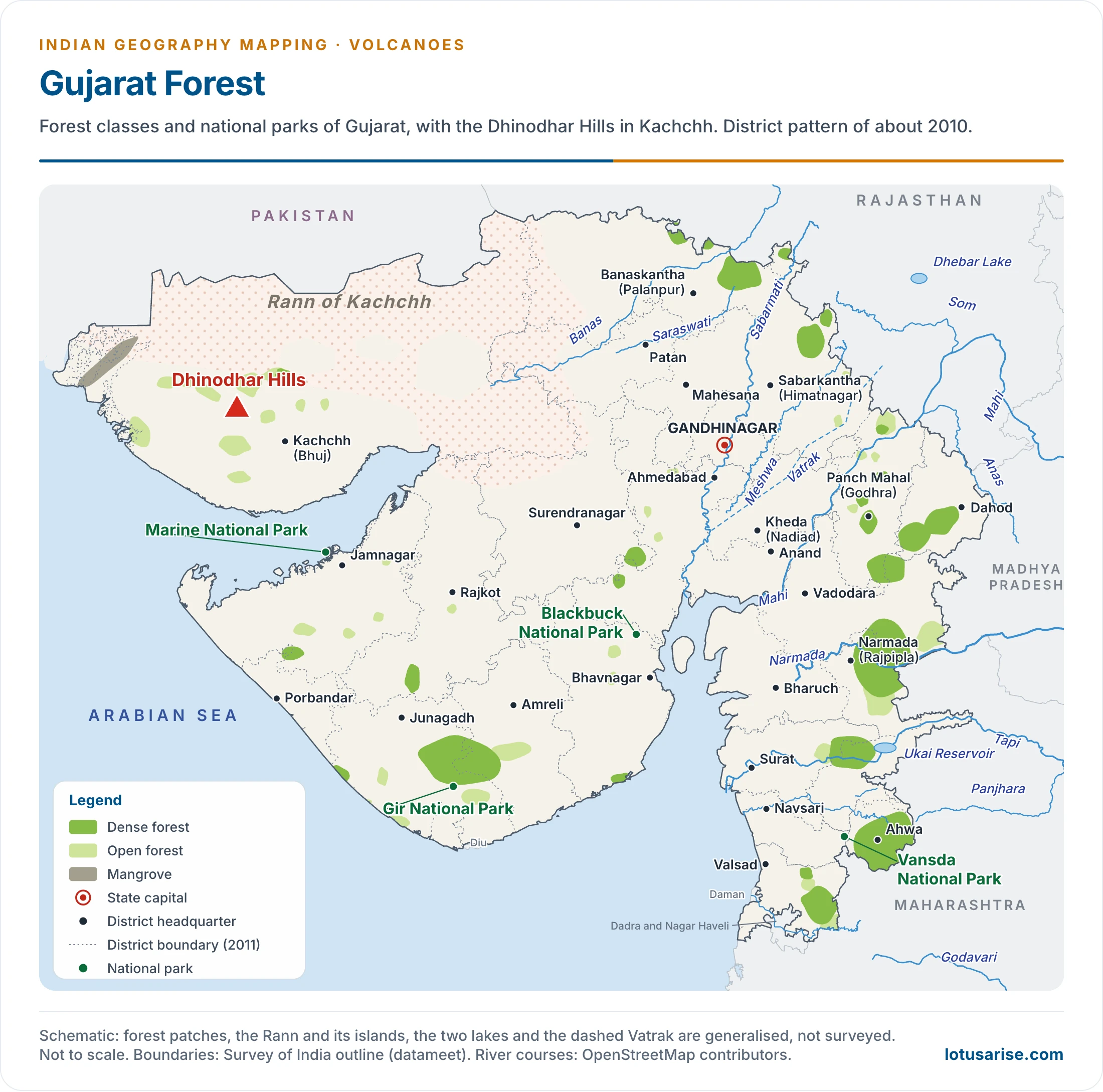
- The Dhinodhar Hills (Dinodhar) stand near Nani Aral village, in Nakhatrana taluka, Kachchh district, Gujarat.
- Dinodhar Hill is an inactive volcanic form, a volcanic plug rising to about 386 m (361 m in another listing) above the local sandstone. Central Kachchh is treated as a volcanic field on the north-western edge of the Deccan province, against the 500 Ma BP of older lists.
- It is a well-known trekking spot of the Kachchh region, and a tourist and pilgrimage site.
Dhosi Hill
- Dhosi Hill is an extinct volcano, standing alone at the north-west end of the Aravalli range, and rising about 345 to 470 m from the surrounding land.
- It belongs to the Precambrian Malani igneous suite, commonly dated to about 750 million years ago.
- It lies on the Haryana–Rajasthan border:
- The Haryana part lies in Mahendragarh district to the south, 5 km from Narnaul on the Singhana Road.
- The Rajasthan part lies in Jhunjhunu district to the north.

Tosham Hills
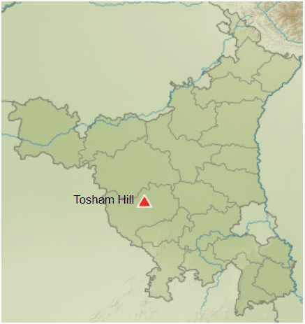
- The Tosham hills lie in Bhiwani district of Haryana, on the north-west spur of the Alwar region, at an average elevation of 207 m.
- The rocks around them are part of the subsurface north-western spur of the Alwar group of the Delhi Supergroup in the Aravalli range, and belong to the Precambrian Malani igneous suite. The Tosham complex is dated to about 730 million years.
- The main Tusham hill is the second largest in the range.
- It has ancient rock inscriptions and rock paintings, old eroded rock channels and water cascades, and small hilltop lakes.
- It is one of the major biodiversity sites in Haryana.
Loktak Lake
- Loktak Lake in Manipur appears on Indian volcano lists as an ancient formation of about 100 Ma BP, with status unknown.
- There is no volcanic cone here. The lake is better known as a Ramsar wetland with floating phumdis, and as the home of the Keibul Lamjao National Park.
Older Vulcanicity
- Six phases of past vulcanicity in India are recognised in older accounts, following Harbans Lal Chhibber (1945):
- Dharwar: the Dalma Trap of Jharkhand.
- Cuddapah: the Cuddapah, Bijapur and Gwalior areas.
- Vindhyan: the Malani rocks of Jodhpur and the Kirana Hills.
- Palaeozoic: Kashmir and Himachal Pradesh, notably the Pir Panjal range and Dalhousie, and Bhowali and Bhimtal in Kumaon.
- Mesozoic: the Rajmahal Hills of Jharkhand and the Abor Hills of Arunachal Pradesh.
- Cretaceous to Eocene: the Deccan Traps.
Previous Year Questions
2021Discuss the economic significance of the volcanic soils of India.2019Map item: Barren Island2018Distinguish the geographical aspects of North-Western lava plateau and Chota Nagpur Plateau of Peninsular India.2015Map item: Narcondam



It is informative
so good