

- India has one of the world’s oldest traditions of geographical ideas. They are scattered through the Vedas, Brahmanas, epics, Puranas, Buddhist and Jain texts and the astronomical siddhantas, rather than set out in a separate science of geography.
- The Sanskrit word bhugola (bhu, earth; gola, sphere) already treats the earth as a globe. It names the geography chapter (Bhugoladhyaya) of the Surya Siddhanta.
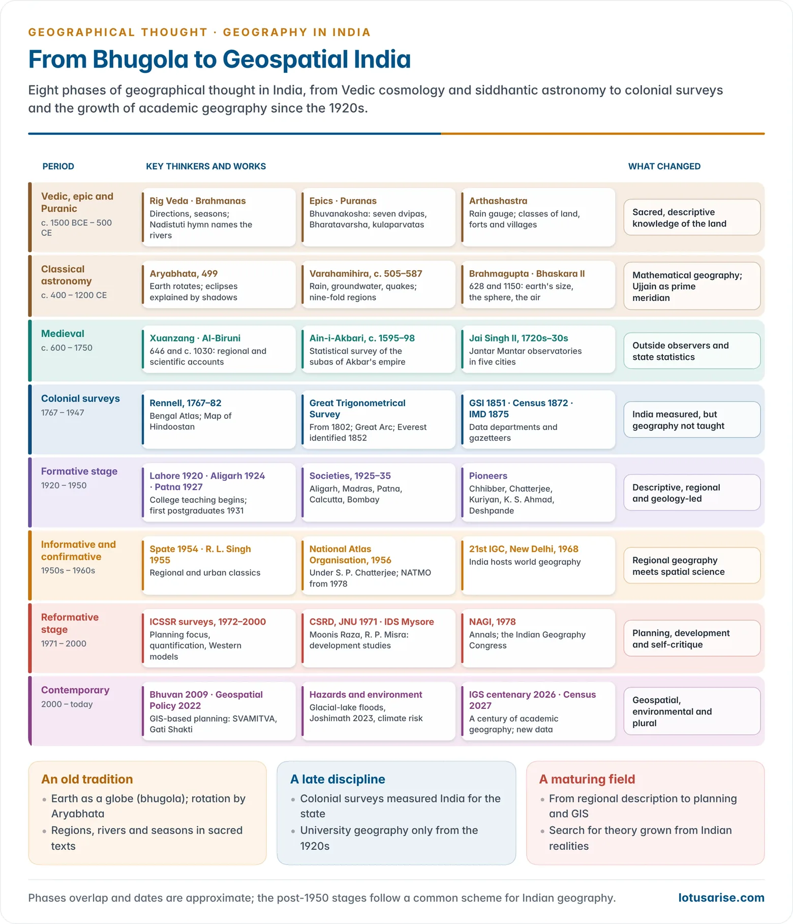
- The tradition runs through four broad phases:
- ancient and classical ideas, which were cosmological, astronomical and descriptive;
- medieval contributions from Arab, Persian and Mughal scholars;
- colonial surveying, which mapped and measured the subcontinent but did not teach geography;
- modern academic geography, which began in colleges only in the 1920s and grew rapidly after 1947.
- Modern Indian geography was transplanted largely from Britain, and later from the United States. Indian geographers still debate how far it should draw on its own heritage and problems.
Ancient and Classical Ideas

Sources
- Vedic texts:
- the Rig Veda names directions, seasons and rivers;
- the Aitareya Brahmana and Shatapatha Brahmana carry material on regions, settlement and the motion of the sun.
- Epics: the Ramayana lists mountains, rivers and places. The Mahabharata is almost an encyclopaedia of regions, peoples and routes, and divides the Himalaya into outer and inner ranges.
- Puranas: the bhuvanakosha (“treasury of the world”) sections of the Vayu, Matsya, Vishnu and Markandeya Puranas describe the earth’s continents, mountains and rivers.
- Buddhist Jatakas and Jain texts describe trade routes, towns and distant lands.
- Astronomical siddhantas carry the mathematical geography.
- Outside accounts add to the picture:
- Megasthenes, Seleucid envoy to Chandragupta Maurya (c. 300 BCE), described India’s rivers, seasons and peoples in his Indica;
- the Greek Periplus of the Erythraean Sea (1st century CE) lists the ports of India’s west coast, such as Barygaza (Bharuch) and Muziris, in the monsoon trade with Rome.
- Physical features were usually given religious meaning. Every great river, peak and tree was sacred, and pilgrimage routes (tirthas) tied the subcontinent together as one sacred space.
Cosmology and the Earth
- Origin of the universe: the Rig Veda’s Nasadiya Sukta (Hymn of Creation) imagines a beginning with neither being nor non-being.
- Other hymns describe creation by divine artisans, or from the sacrifice of the cosmic person (Purusha).
- The Puranas describe a vast egg-shaped universe (Brahmanda) with many upper and lower worlds.
- Shape of the earth:
- The Aitareya Brahmana explains that the sun never really sets but passes to the other side of the earth, making night here and day there.
- Astronomers inferred a spherical earth from the round shadow on the moon during eclipses.
- Most classical astronomy remained geocentric.
- Five elements (pancha mahabhuta):
| Element | Sanskrit | Linked sense |
|---|---|---|
| Earth | Prithvi | Smell |
| Water | Ap (Jala) | Taste |
| Fire | Agni (Tejas) | Sight |
| Air | Vayu | Touch |
| Ether / space | Akasha | Sound |
- The Vaisheshika school of Kanada held that matter is made of indivisible atoms (paramanu).
- The three worlds: the earth (prithvi), the intermediate space (antariksha, where winds, clouds and lightning move) and the sky (dyaus).
- Bhaskara II set the depth of the atmosphere, the zone of winds, clouds and rain, at 12 yojanas above the earth.
Mathematical Geography and Astronomy
- The siddhanta astronomers carried geography into measurement. They worked on the size of the earth, latitude, longitude, local time and eclipses.
| Scholar | Date | Key work | Geographical contribution |
|---|---|---|---|
| Surya Siddhanta (anonymous) | core c. 4th–5th c. CE, revised later | Bhugoladhyaya chapter | Earth’s diameter and circumference; motion of planets; term bhugola |
| Aryabhata | b. 476 CE | Aryabhatiya (499 CE) | Earth rotates on its axis; eclipses explained by shadows; earth’s diameter of 1,050 yojanas |
| Varahamihira | c. 505–587 CE | Brihat Samhita, Pancha Siddhantika | Rain forecasting, cloud and wind signs, groundwater divining, earthquakes |
| Brahmagupta | 598–c. 668 CE | Brahmasphutasiddhanta (628 CE) | Rules for zero; astronomical computation; earth’s circumference |
| Bhaskara II | 1114–1185 CE | Siddhanta Shiromani (1150) | Goladhyaya: the sphere, gravitation-like attraction, the atmosphere’s depth |
- Aryabhata’s key insight: the apparent daily turning of the stars is caused by the earth’s rotation. He compared it to a boatman who sees the bank moving backward.
- He explained eclipses by the shadows of the earth and moon, rejecting the demons Rahu and Ketu, and held that the moon shines by reflected sunlight.
- He did not propose a sun-centred system. His model remained geocentric.
- Latitude and longitude (akshamsha and deshantara):
- Indian astronomers placed Lanka on the equator and Meru at the North Pole.
- They took the meridian of Ujjain as their prime meridian.
- They worked out longitude differences by timing the same lunar eclipse at different places.
- Kautilya’s Arthashastra (c. 4th century BCE onwards) records rainfall with a rain gauge (varshamana). It notes different amounts for different regions and uses them to assess crops and revenue: an early applied, economic geography.
Regions and Settlements
- Early regional units: the sixteen mahajanapadas of the 6th century BCE were territorial states named after peoples and rivers. They were the first political regions of the Ganga plain.
- Varahamihira’s kurma-vibhaga in the Brihat Samhita divides Bharatavarsha into nine regions arranged like the body of a tortoise round a central Madhyadesha. It was an early regional division of India.
- Settlement planning:
- the Harappan cities (c. 2600–1900 BCE) were laid out on grids with drainage;
- the Arthashastra classifies land, forts and villages;
- the vastu texts (such as the Manasara) set out village and town plans.
Directions and Seasons
- The Rig Veda knew four directions (purva, dakshina, paschima, uttara). Adding the zenith and nadir gave six, and the Puranas used eight and ten, each ruled by a deity (Indra in the east, Agni in the south-east, Yama in the south, and so on).
- Seasons (ritus):
- The Rig Veda names five: vasanta, grishma, varsha, sharad and hemanta.
- Later texts add shishira to make six two-month seasons.
- It is a calendar fitted to the monsoon climate of northern India.
The Puranic Dvipas
- A dvipa literally meant land with water on two sides: an island, a peninsula or a doab.
- In the Puranas it became a continent or natural region set off by seas, deserts, mountains or forest.
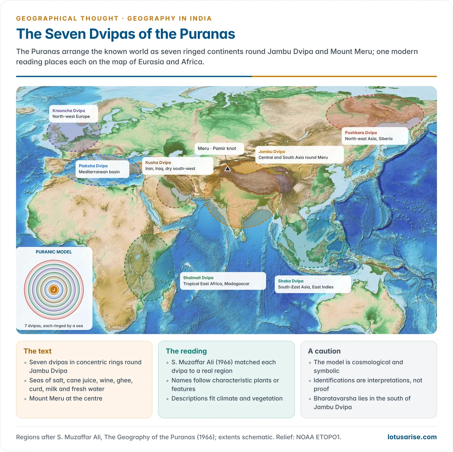
- The concentric model: seven dvipas ring the central Jambu Dvipa, each surrounded by a sea. The seas are of salt water, sugar-cane juice, wine, ghee, curds, milk and fresh water. Mount Meru stands at the centre.
- The model is symbolic, but the geographer S. Muzaffar Ali (The Geography of the Puranas, 1966) read the descriptions as real regions:
| Dvipa | Named after | Region in S. M. Ali’s reading |
|---|---|---|
| Jambu | Jambu tree | Central and South Asia round the Pamir (Meru) |
| Plaksha | Plaksha (fig) tree | Mediterranean basin |
| Kusha | Kusha grass | Iran, Iraq and the dry lands to the south-west |
| Shalmali | Silk-cotton tree | Tropical East Africa and Madagascar |
| Krauncha | Krauncha mountain | North-west Europe |
| Shaka | Shaka (teak) tree | South-East Asia and the East Indies |
| Pushkara | Lotus lakes | North-east Asia and Siberia |
Bharatavarsha
- Bharatavarsha, the southern division of Jambu Dvipa, is the Puranic name for the land from the Himalaya to Kanyakumari. It was named after a legendary king Bharata.
- Earlier names were regional:
- Saptasindhava, the land of seven rivers in the Vedic Punjab;
- Aryavarta, the land between the Himalaya and the Vindhya;
- Hindu/India, the Persian and Greek name for the Indus lands.
- The Puranas divide Bharatavarsha into nine divisions (nava khanda).
- Earlier names were regional:
- Mountains: the seven kulaparvatas (clan mountains) are Mahendra (Eastern Ghats), Malaya (southern Western Ghats), Sahya (northern Western Ghats), Shuktiman, Riksha, Vindhya and Pariyatra (western Vindhya–Aravalli).
- Rivers: the Nadistuti hymn of the Rig Veda (10.75) lists the rivers of the north-west:
- the Ganga and Yamuna;
- the Sarasvati;
- the Shutudri (Sutlej), Parushni (Ravi), Asikni (Chenab) and Vitasta (Jhelum);
- the Sindhu (Indus) and its western tributaries, the Kubha (Kabul), Gomati (Gomal) and Krumu (Kurram).
- The epics and Puranas add the peninsular rivers: Narmada, Tapi, Godavari, Krishna, Kaveri and Tungabhadra. They also add the Lauhitya (Brahmaputra).
Medieval Contributions
- Chinese pilgrims gave outsiders’ regional geographies of India.
- Faxian travelled c. 399–412 CE.
- Xuanzang (journey 629–645) described its kingdoms, climate, products and customs in the Great Tang Records on the Western Regions (646).
- Al-Biruni’s Kitab al-Hind (c. 1030) was the first scientific outsider’s account of India’s geography, astronomy and society.
- He measured the latitudes of Indian places and explained the alluvial origin of the Gangetic plain, which he saw as filled by river deposits.
- He is treated more fully among the Arab geographers.
- Ibn Battuta served in Muhammad bin Tughluq’s Delhi (1334–42) and described Indian towns, roads, crops and the Malabar coast.
- Indian Ocean navigation: Gujarati, Konkani and Arab pilots sailed by monsoon timetables and star-altitude rules. A Gujarati pilot took Vasco da Gama’s fleet from Malindi to Calicut in 1498.
- Mughal statistical geography:
- Babur’s memoirs (Baburnama) describe Hindustan’s landscape, seasons, crops and fauna.
- Abul Fazl’s Ain-i-Akbari (c. 1595–98), the third part of the Akbarnama, surveys the twelve subas of Akbar’s empire.
- It records their areas, revenue, crops, prices, rivers and products. It is an early statistical and economic geography of a state.
- Sawai Jai Singh II built observatories (Jantar Mantar) at Delhi, Jaipur, Ujjain, Varanasi and Mathura in the 1720s–30s to refine astronomical tables.
Colonial Geography: Surveying Without Teaching
Surveys and Scientific Departments
- The East India Company and the Crown measured India to govern, tax, defend and exploit it. Geography served as a tool of empire.
- Mapping:
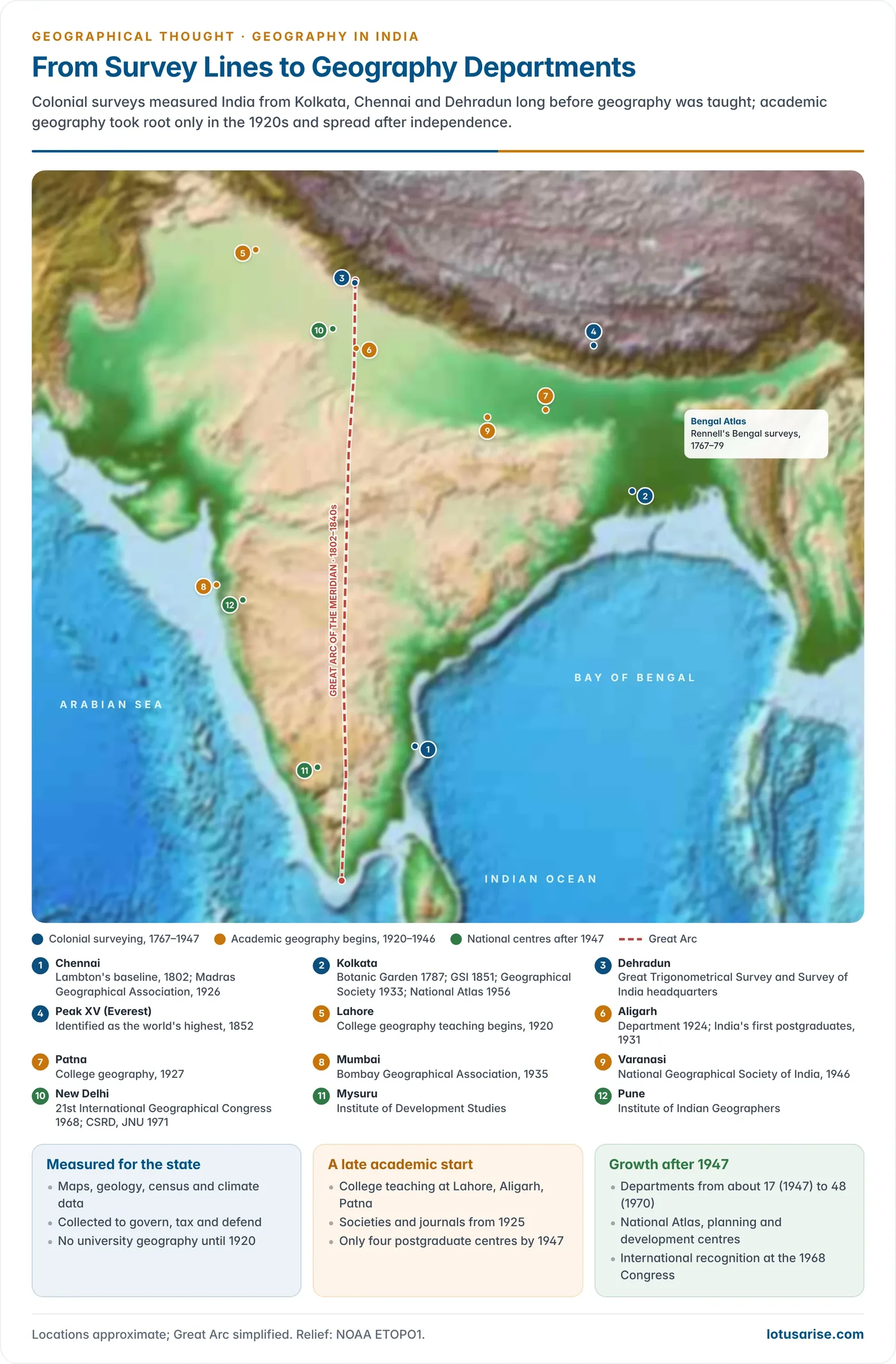
- The Survey of India traces its origin to 1767, when James Rennell became Surveyor General of Bengal.
- Rennell’s Bengal Atlas (1779) and Map of Hindoostan (1782, with its Memoir) were the first scientific maps of the subcontinent. They earned him the title “father of Indian geography”.
- The Great Trigonometrical Survey (from 1802, under William Lambton, continued by George Everest) measured the Great Arc of the meridian from Kanyakumari towards the Himalaya.
- In 1852 the computer Radhanath Sikdar identified Peak XV as the world’s highest. It was named Mount Everest in 1865. Its height is now fixed at 8,848.86 m (2020).
- Scientific departments produced the data later geographers used:
| Institution | Founded | Information produced |
|---|---|---|
| Survey of India | 1767 | Topographical maps, geodesy |
| Indian Botanic Garden, Calcutta | 1787 | Plant collections, economic botany |
| Geological Survey of India | 1851 | Rocks, minerals, coal |
| Archaeological Survey of India | 1861 | Past settlements and cultures |
| Census of India | 1872 (first synchronous 1881) | Population, caste, language, occupation |
| India Meteorological Department | 1875 | Monsoon and climate records |
| Botanical Survey of India | 1890 | Vegetation |
| Zoological Survey of India | 1916 | Fauna |
- Indian surveyors: trained Indian “pundits” carried the survey into closed lands. Nain Singh Rawat (1865–66) paced and measured his way to Lhasa and fixed its position and altitude. He later received the Royal Geographical Society’s gold medal (1877).
- Compilations:
- W. W. Hunter’s Imperial Gazetteer of India (1881; 26 volumes in 1907–09), with hundreds of provincial and district gazetteers;
- George Grierson’s Linguistic Survey of India (1894–1928).
- Yet geography as a discipline was barely taught.
- Universities were founded at Calcutta, Bombay and Madras (1857), Allahabad (1887) and Lahore (1882), but none had a geography department.
- Schools taught lists of names and places. Geology, with its practical value, attracted those interested in the earth.
- Boundaries as colonial legacies: survey lines such as the Durand Line (1893) and the McMahon Line (1914) became international frontiers. They still shape South Asia’s political geography.
- Colonial categories: censuses fixed categories of caste, religion and language in ways that later shaped politics. Critical scholars now read such surveys as instruments of power as well as sources of data.
Beginnings of Academic Geography
- Undergraduate teaching began in colleges affiliated to Lahore (1920), at Aligarh (1924) and at Patna (1927).
- Aligarh produced India’s first postgraduate batch in 1931.
- Early societies and journals:
- Curzon Geographical Society, Aligarh (1925);
- Madras Geographical Association, founded by N. Subrahmanyam in 1926 (now the Indian Geographical Society, publisher of the Indian Geographical Journal). It marked its centenary in 2026.
- Patna College Geographical Society (1929);
- Calcutta (later Geographical Society of India) (1933), publisher of the Geographical Review of India;
- Bombay Geographical Association (1935).
- Many early heads of department were geologists, economists or commerce teachers.
- The first geographers included:
- H. L. Chhibber (geomorphology) and S. P. Chatterjee (Calcutta);
- N. Subrahmanyam and George Kuriyan (Madras);
- K. S. Ahmad (Lahore) and Tahir Rizvi (Aligarh);
- R. N. Dubey (Allahabad);
- S. M. Ali, C. D. Deshpande and M. B. Pithawalla.
- The first geographers included:
- By 1947 only Aligarh, Calcutta, Allahabad and Banaras taught geography at postgraduate level. In K. M. Panikkar’s words (1955), India had neglected its geography, and “a nation can neglect its geography only at its peril”.
Modern Indian Geography
- Indian geography since independence is usually traced through four stages.
- It moved from British-style regional description to American-style spatial science, then to planning and development. It did so without the bitter dichotomies of Western geography.
The Formative Stage (before 1950)
- The pioneers came from other disciplines.
- Their method was descriptive and idiographic: regional and physical accounts in the British chorological mould, much of it geomorphology inherited from geology.
- Societies and their journals carried most of the research.
The Informative Stage (1950s)
- Geography gained a national base. Departments multiplied, from about 17 in 1947 to 48 by 1970, and Agra, Panjab, Madras and Patna began postgraduate teaching around 1950.
- Landmark works:
- O. H. K. Spate’s India and Pakistan: A General and Regional Geography (1954; revised with A. T. A. Learmonth, 1967) set the standard for regional geography and proposed a hierarchy of regions;
- R. L. Singh’s Banaras: A Study in Urban Geography (1955) opened urban studies.
- The National Geographical Society of India (Varanasi, 1946) grew up around the Banaras school.
- The National Atlas Organisation was set up in 1956 under S. P. Chatterjee (Shiba Prasad Chattopadhyay). It was renamed the National Atlas and Thematic Mapping Organisation (NATMO) in 1978. It produced the National Atlas of India.
- Planning drew geographers in.
- Spate and Learmonth advised on geography’s role in national planning.
- The Damodar Valley and other diagnostic surveys (late 1950s) were given to geography departments.
- C. D. Deshpande had already proposed planning regions for Bombay Province in 1948.
- V. L. S. Prakasa Rao led the regional survey of Mysore State at the Indian Statistical Institute, an early model of planning-oriented regional analysis. He is regarded as a pioneer of regional planning in India.
The Confirmative Stage (1960s)
- The 21st International Geographical Congress met in New Delhi in 1968, under S. P. Chatterjee as President of the International Geographical Union. This was international recognition.
- Stock-taking: S. P. Chatterjee’s review of geography for the Indian Science Congress, in Fifty Years of Science in India (1964), and his country report of 1968 found three strands.
- Physical geography covered the Himalaya, the plains, the deserts and the coasts.
- Economic geography covered agriculture, irrigation, minerals and the Bihar–Bengal–Odisha industrial belt.
- Cultural geography covered towns, rural settlement and population.
- About 36 universities taught postgraduate geography. New journals appeared, including:
- Transactions of the Institute of Indian Geographers (Pune);
- Deccan Geographer (Secunderabad);
- Indian Journal of Geography (Jodhpur);
- Geographical Outlook (Ranchi);
- the Hindi Uttar Bharat Bhoogol Patrika (Gorakhpur).
- Regionalisation became a speciality:
- P. Sengupta and Galina Sdasyuk’s economic regionalisation of India (1968);
- later, R. L. Singh’s India: A Regional Geography (1971), with macro, meso and micro regions.
- A second generation trained in the United States (G. S. Gosal, R. P. Misra, C. R. Pathak and others) brought back quantitative methods and spatial science.
The Reformative Stage (since 1971)
- ICSSR surveys of research charted the discipline:
| Survey | Published | Main findings |
|---|---|---|
| First | 1972 | Eight fields reviewed; research still mostly descriptive and cartographic |
| Second (ed. Moonis Raza) | 1979 | Concern with planning; links to other social sciences; quantitative methods; little generalisation; heavy use of Western models |
| Third (ed. S. M. Alam) | 1984 | Economic, social, population, settlement and regional–development themes |
| Fourth (ed. G. S. Gosal) | 1999–2000 | Quantification, model building, better data handling, social processes, development orientation |
- Applied institutions led by geographers:
- the Centre for the Study of Regional Development, JNU (Moonis Raza, 1971);
- the Institute of Development Studies, University of Mysore (R. P. Misra);
- the Centre for Area Studies, Osmania (S. M. Alam).
- National bodies:
- the National Association of Geographers, India (NAGI) (1978), with its Annals and an annual Indian Geography Congress;
- the Institute of Indian Geographers (Pune);
- specialised bodies such as the Association of Population Geographers of India (Chandigarh) and the Regional Science Association of India.
- Self-criticism:
- Moonis Raza (1979) argued that Indian geography had accepted a ready-made system of ideas without taking part in making it, and took little interest in theory.
- Others criticised the uncritical use of Western models (central places, growth poles) and an urban bias in a rural country.
- B. Arunachalam (1980) asked why geography in a largely rural country neglected rural development, floods and droughts.
- P. Dayal (1994) warned that physical geography was being reduced to geomorphology and left to environmental scientists.
Leading Geographers and Their Fields
| Field | Representative Indian geographers |
|---|---|
| Regional geography and regionalisation | S. P. Chatterjee, R. L. Singh, L. S. Bhat, P. Sengupta |
| Regional development and planning | V. L. S. Prakasa Rao, C. D. Deshpande, R. P. Misra, K. V. Sundaram, C. R. Pathak |
| Urban geography | R. L. Singh, R. Ramachandran, Moonis Raza |
| Climatology | P. Dayal |
| Transport and resource geography | H. Ramachandran, B. Thakur |
| Agricultural geography | Mohammad Shafi, Jasbir Singh |
| Population geography | G. S. Gosal, Gopal Krishan, R. C. Chandna |
| Geomorphology | H. L. Chhibber, Enayat Ahmad, S. R. Basu, V. S. Kale, A. Kar |
| Political and administrative geography | C. P. Singh, Swaranjeet Mehta, Gopal Krishan, Suryakant |
| Cultural and social geography | A. B. Mukerji, Kashi Nath Singh, Aijazuddin Ahmad, M. Ishtiaque |
| Medical geography | Rais Akhtar, Jayati Hazra |
| Gender geography | Saraswati Raju |
| Cartography and thematic mapping | S. P. Chatterjee, S. P. Das Gupta, S. M. Alam, B. K. Roy |
Contemporary Trends
- Geospatial technology: remote sensing and GIS, built on ISRO’s satellites and the Bhuvan portal (2009), now underpin resource mapping, disaster management and planning.
- The liberalised geospatial guidelines (2021) and the National Geospatial Policy (2022) opened map data to private and academic users.
- Programmes such as SVAMITVA (drone mapping of village land, 2020) and PM Gati Shakti (a GIS-based national infrastructure master plan, 2021) use geographical methods at national scale.
- Environment and hazards: climate change, Himalayan glacial-lake floods, land subsidence (Joshimath, 2023), coastal erosion, droughts and floods are major research themes. Physical geography is reviving under the banner of environmental science.
- Decentralised and regional planning: the 73rd and 74th Amendments (1992) created demand for district and local-level planning, an old strength of Indian regional geography.
- Data: the Census 2027, India’s first fully digital census and the first since 1931 to enumerate caste, will reset the base data for population and social geography.
- Social themes: social well-being, gender, caste and tribal spaces, health, migration and urban informality reflect the critical turn in the subject.
- Indigenous perspectives: scholars now call for an Indian methodology that draws on the man–nature harmony of older traditions and on India’s own problems. This is part of the wider challenge to the Eurocentric history of the discipline.
- R. P. Misra (1996) argued that the ancient idea of symbiosis between people and nature could offer an alternative to the determinism–possibilism frame.
- Education: the National Education Policy 2020 promotes geography’s interdisciplinary role. Geography remains one of the most widely chosen optional subjects in civil service examinations.
Evaluation
- Strengths:
- a long heritage of observation, measurement and regional description, with astronomical geography comparable to the Greek;
- the colonial data inheritance of maps, census and gazetteers;
- a strong record in regionalisation and planning.
- Weaknesses:
- a late academic start;
- dependence on Anglo-American paradigms;
- limited theory-building;
- neglect of historical, political and physical geography for long periods.
- Outlook:
- Indian geography is younger than modern geography. In 1982 N. B. K. Reddy called it about 50 years old, against some 150 years for modern geography in Europe.
- Its future lies in combining geospatial skill, field knowledge and theory grown out of Indian realities.
Previous Year Questions
- No direct PYQ has been asked on this sub-topic yet.




