

- Coal is a combustible sedimentary rock, black or brownish-black, rich in carbon and hydrocarbons. It is India’s largest primary energy source, with 59.21% of total primary energy supply in 2024-25.
- India’s coal falls into two geological groups: the old Gondwana coalfields of the Peninsula and the young Tertiary coalfields of the extra-Peninsula.
- The national inventory of 1 April 2025 puts coal resources at 400.72 billion tonnes and lignite at 47.37 billion tonnes. Output in 2024-25 was 1,047.52 million tonnes.
Nature, Origin and Types of Coal
What Coal Is
- Coal counts as a non-renewable source, because nature takes millions of years to make it. It holds energy that plants of ancient swampy forests once stored.
- Its high value as fuel and as industrial raw material has earned it the name black gold.
- Constituents: carbon, volatile matter, moisture and ash, with sulphur and phosphorus in some cases.
- Other elements present are hydrogen, oxygen and nitrogen.
- Chlorine and sodium are among the undesirable constituents.
- Uses: mainly power generation and metallurgy. In 2024-25 the power sector took 76% of coal consumed and iron and steel about 7%.
- Older accounts put coal at about 70% of commercial energy, with power and industry taking 94% of it.
- Three things separate one coal from another:
- Coal type: the kind of plant material.
- Coal rank: the degree of coalification.
- Coal grade: the range of impurities.
Formation of Coal
- Dead plant matter first decays into peat. Heat and pressure of deep burial then turn peat into coal over millions of years.
- The sequence runs as follows:
- Swampy, marshy forests grew, and dying plants dropped into the swamp water while new ones took their place.
- A thick mat of rotting vegetation built up on the swamp floor.
- The land surface changed, and water and sediment washed in. This halted further decay.
- Fresh vegetation grew and died, so layer upon layer accumulated over millions of years.
- The weight above compacted the lower layers.
- Heat and pressure drove out oxygen and left carbon-rich deposits, which became coal.
- The world’s great Carboniferous coal formed around 300–350 million years ago. India’s main coal is younger and belongs to the Permian, within the Gondwana system.
- Chemistry of the change: hydrogen escapes as methane and water, and oxygen as carbon dioxide and water, so the proportion of carbon rises. Heating value depends on that carbon, which in turn depends on how long and how intensely heat and pressure acted.
- Coalification runs in one direction: peat → lignite → sub-bituminous → bituminous → anthracite.
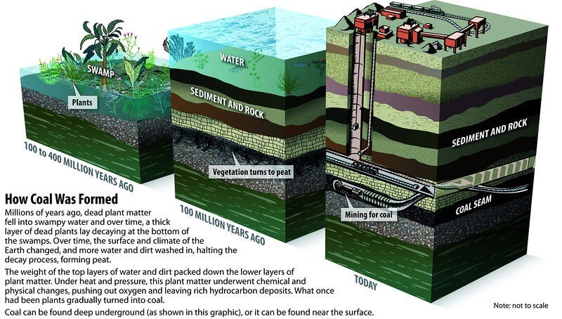
- The dates on this figure are a general world account. India’s Gondwana coal dates from about 299 million years ago.
Types of Coal
- Coal is ranked by the amount of carbon, oxygen and hydrogen it contains. The four standard ranks are anthracite, bituminous, sub-bituminous and lignite, and peat is the precursor to all of them.
- Indian accounts usually describe four varieties by carbon content, as in the table.
| Variety | Carbon | Moisture and volatiles | Character | Where in India |
|---|---|---|---|---|
| Anthracite | 80–95% | Very little | Hard, jet black, semi-metallic lustre; highest heating value | Only Kalakot, Jammu and Kashmir, in small amounts |
| Bituminous | 60–80% (wider definitions from 40%) | Volatiles 15–40% | Dense, black, banded; no trace of plant matter | Jharkhand, Odisha, West Bengal, Chhattisgarh, Madhya Pradesh |
| Lignite (brown coal) | 40–55% | Moisture over 35% | Dark to black-brown; friable; much smoke, little heat | Palana, Neyveli, Lakhimpur, Karewas of Kashmir |
| Peat | Below the lignite range of 40–55% | High moisture, ample volatiles | First stage from wood; loose, burns like wood | Nilgiris, Kashmir valley, Kolkata, Ganga delta |
- Anthracite ignites slowly with a short blue flame and is the most prized variety.
- Bituminous is the most widely used coal, and its name comes from the bitumen released on heating.
- High carbon and low moisture give it a very high calorific value.
- It therefore serves for steam raising, heating, coke and gas.
- The range is wide enough that it is often split into sub-bituminous and bituminous.
- Lignite is an intermediate stage between woody matter and coal. Left in the open, it tends to crumble and can even catch fire by itself.
- Peat is seldom compact enough to be good fuel unless pressed into bricks. Burnt loose, it gives little heat, more smoke and much ash.
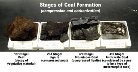
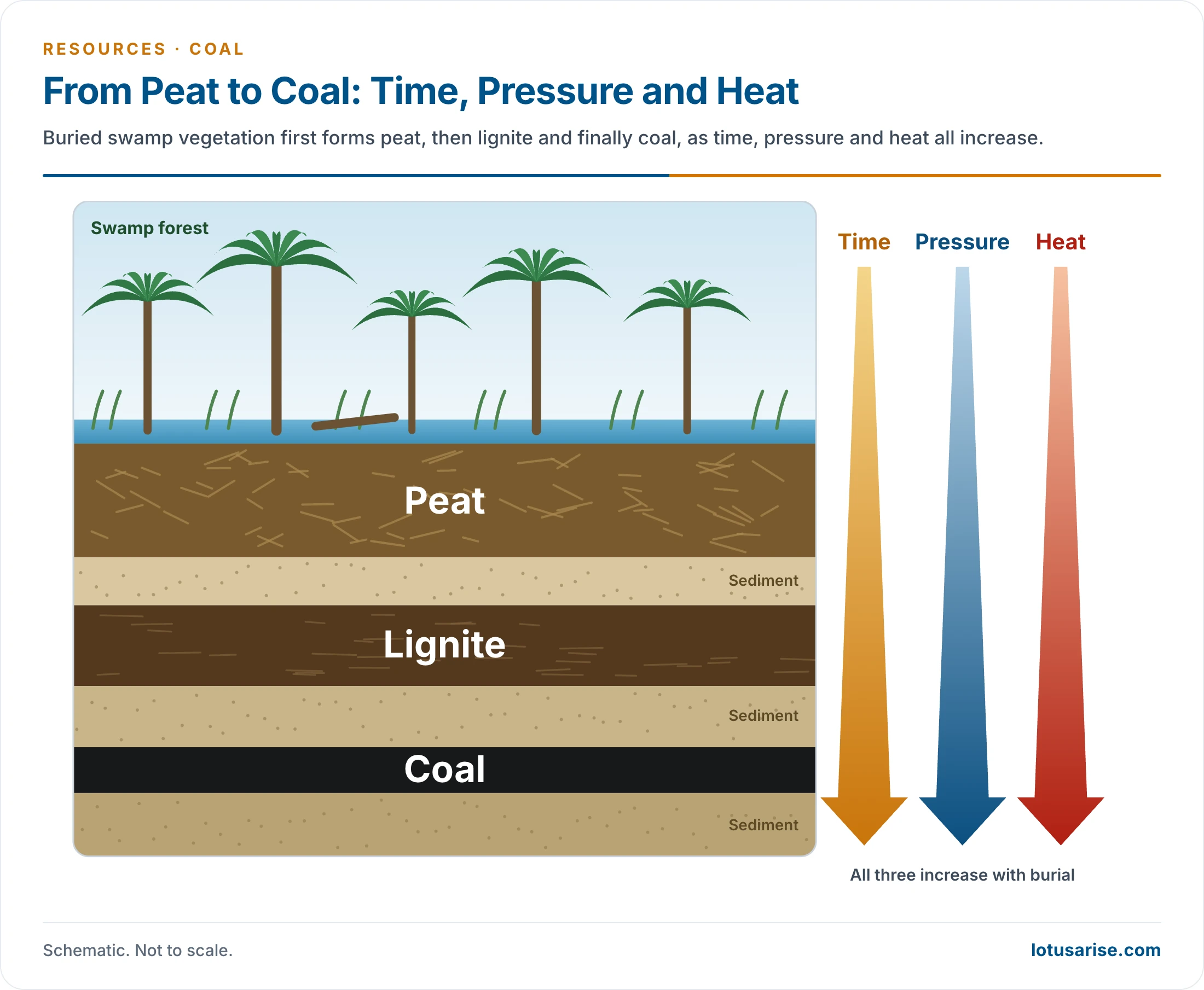
Coking and Non-Coking Coal
| Point | Coking or metallurgical coal | Thermal, non-coking or steaming coal |
|---|---|---|
| Quality | High carbon; less moisture, sulphur and ash | Higher sulphur, so unfit for iron and steel |
| Coke | Baked without air at very high temperature to make coke | Coking is uneconomic, and sulphur traces survive it |
| Use | Essential for steel | Power generation |
| Older list of producers | Australia, Canada, United States | China, Australia, USA, Russia |
| Older list of exporters | Australia, Canada, United States | Australia, South Africa |
| India’s output, 2024-25 | 66.47 million tonnes | 981.05 million tonnes (93.65%) |
| India’s imports, 2024-25 | 57.58 million tonnes | 186.05 million tonnes |
- Sulphur is especially harmful to the iron and steel industry.
- China has long imported large amounts of coking coal from Australia, and India also relies on imports for its coking coal.
- Jharkhand dominated coking output in 2013-14, with more than 90%, ahead of West Bengal and Madhya Pradesh.
Occurrence, Reserves and Production
Gondwana and Tertiary Coal
| Feature | Gondwana | Tertiary |
|---|---|---|
| Age | Classically 250 million years; now dated from about 299 million years | 15–60 million years (Eocene to Oligocene-Miocene) |
| Share of resources | Older count 98%; now 399.02 billion tonnes, 99.6% | 1.69 billion tonnes, about 0.4%; all high-sulphur |
| Share of output | About 99% | Very small |
| Region | Peninsular valleys | Extra-Peninsula, mainly the North-East |
| Carbon | Rarely above 55–60% | Very low |
| Moisture and sulphur | Almost no moisture; some sulphur and phosphorus | High moisture and sulphur |
Gondwana Coalfields
- These fields are the source of India’s metallurgical and superior coal, both coking and non-coking, and bituminous and sub-bituminous. Anthracite is generally absent.
- Carbon stays limited because volatile compounds and ash run high, usually 13–30%.
- It has less carbon than Carboniferous coal elsewhere, about 350 million years old. That older coal is almost absent in India. Gondwana coal is younger and has had less time to mature.
- The Damuda series of the Lower Gondwana, named after the Damodar, holds the best-worked fields, with about 80% of output. 80 of India’s 113 major fields lie in these rocks.
- About 75 separate basins cover some 77,700 sq km, and range from 1 to 1,550 sq km each.
- They occupy river valleys in faulted troughs:
- Damodar (Jharkhand–West Bengal)
- Mahanadi (Chhattisgarh–Odisha)
- Son (Madhya Pradesh–Jharkhand)
- Godavari and Wardha (Maharashtra–Andhra Pradesh and Telangana)
- Indravati, Narmada, Koel, Panch, Kanhan and others
- More coal-bearing rock may lie under the Deccan Trap. Erosion has exposed such strata at several places, chiefly in the Satpura range.
Tertiary Coalfields
- These are younger, poorer coals found mostly outside the Peninsula.
- Important areas: Assam, Meghalaya, Nagaland, Arunachal Pradesh, Jammu and Kashmir, the Himalayan foothills of Darjeeling, Rajasthan, Uttar Pradesh and Keralam (Kerala).
- Tamil Nadu and Puducherry are the Peninsular exceptions.
Reserves
- The Geological Survey of India prepares the national inventory, down to 1,200 m and for seams of 0.90 m or more.
- Rising count: 293.50 billion tonnes (2008), 319.02 billion tonnes (2018) and 400.72 billion tonnes (1 April 2025).
- By category, 1 April 2025: measured or proved 55%, indicated 37% and inferred 8%.
- Only the proved part is both geologically confirmed and economically viable, so the headline total overstates what can be mined today.
- By type, 1 April 2025:
- Prime coking: 5.44 billion tonnes, all of it in Jharkhand.
- Medium coking: 30.13 billion tonnes.
- Semi-coking: 1.80 billion tonnes.
- Non-coking: 361.65 billion tonnes, about 90%.
- Odisha has overtaken Jharkhand at the head of the list. Three States, Odisha, Jharkhand and Chhattisgarh, hold about 70%.
| State | Older figure (billion tonnes) | Older share (%) | 1 April 2025 (billion tonnes) | Share (%) |
|---|---|---|---|---|
| Odisha | 75.07 | 24.89 | 100.98 | 25.20 |
| Jharkhand | 80.71 | 26.76 | 93.25 | 23.27 |
| Chhattisgarh | 52.53 | 17.42 | 85.26 | 21.28 |
| West Bengal | 31.31 | 10.38 | 34.39 | 8.58 |
| Madhya Pradesh | 25.67 | 8.51 | 33.56 | 8.38 |
| Telangana | 22.48, with Andhra Pradesh | 7.45 | 23.29 | 5.81 |
| Maharashtra | 10.98 | 3.64 | 13.59 | 3.39 |
| Bihar | in Others | – | 9.35 | 2.33 |
| Andhra Pradesh | with Telangana | – | 4.17 | 1.04 |
| Others | 2.81 | 0.95 | 2.87 | 0.72 |
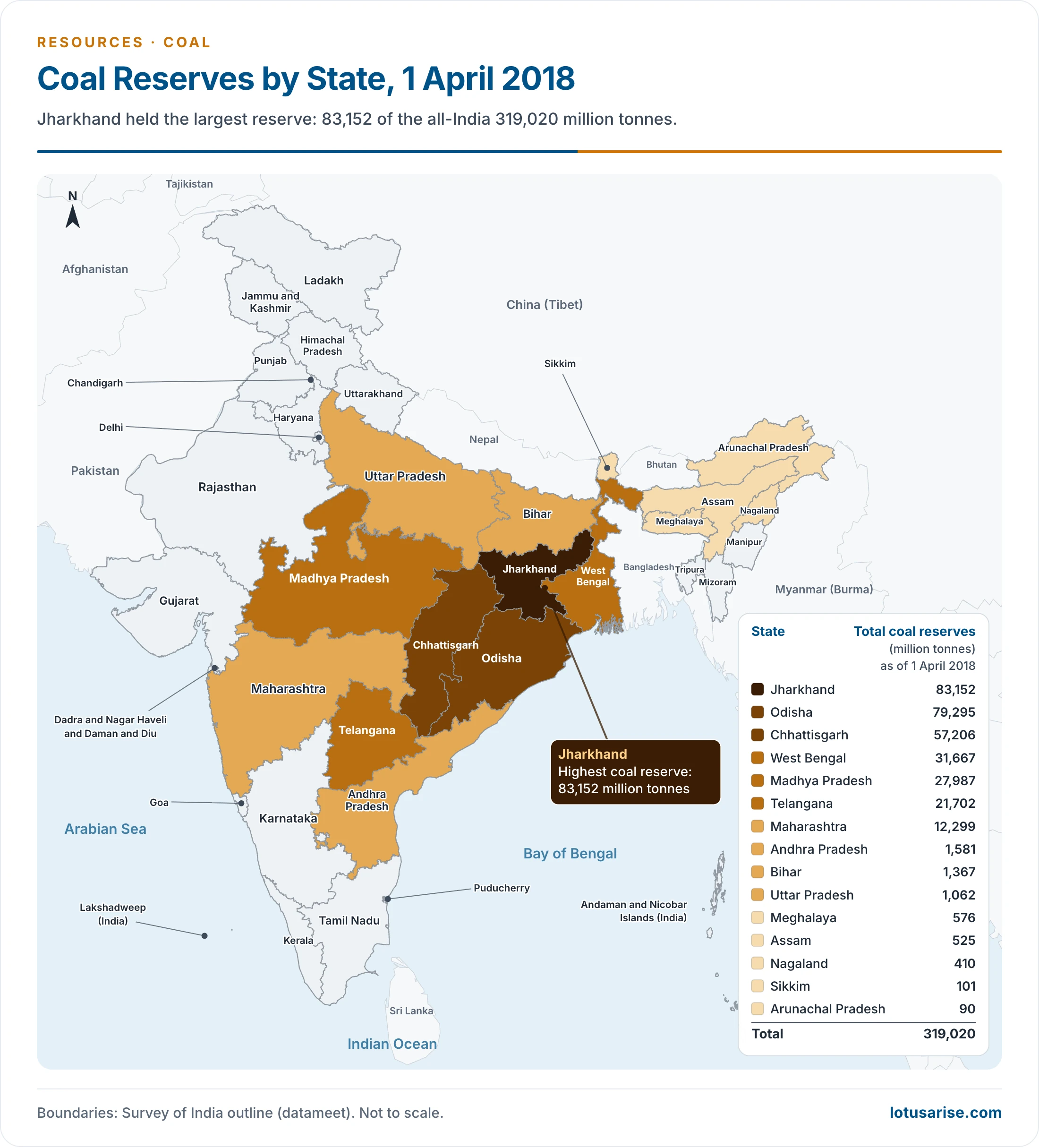
- This map gives the position on 1 April 2018. Every State’s figure has since risen, and Odisha now leads Jharkhand.
- Largest fields by resource, 1 April 2025:
| Coalfield | State | Billion tonnes |
|---|---|---|
| Talcher | Odisha | 56.82 |
| Mand-Raigarh | Chhattisgarh | 52.39 |
| Ib River | Odisha | 44.16 |
| Raniganj | West Bengal and Jharkhand | 28.83 |
| Godavari Valley | Telangana and Andhra Pradesh | 27.46 |
| North Karanpura | Jharkhand | 21.35 |
| Rajmahal | Jharkhand | 20.84 |
| Jharia | Jharkhand | 19.83 |
| Singrauli | Madhya Pradesh and Uttar Pradesh | 19.18 |
Production
- Early history:
- Mining began at Raniganj in 1774, under Sumner and Heatly of the East India Company.
- Regular working in the same area dates from 1814.
- Nationalisation came in two steps, and Coal India Limited followed in 1975:
- Coking coal mines: 1 May 1972.
- All remaining mines: 1 May 1973.
- Reopening: the Coal Mines (Special Provisions) Act of 2015 allowed allocation through auction. Captive and commercial mines reached 210.46 million tonnes in 2025-26.
| Year | Coal output (million tonnes) | Lignite (million tonnes) |
|---|---|---|
| 1950-51 | 32.30 | – |
| 1980-81 | 113.91 | 5.11 |
| 2000-01 | 309.63 | 22.95 |
| 2013-14 | 565.64 | 44.18 |
| 2023-24 | 997.83 | – |
| 2024-25 | 1,047.52 | about 45.13 |
| 2025-26 (provisional) | about 1,040 | – |
- Who produces, 2024-25: Coal India 781.06 million tonnes (74.56%), Singareni Collieries 69.01 million tonnes (6.59%), and captive and other mines the rest. Coal India slipped to 768.19 million tonnes in 2025-26.
- Mining method, 2024-25: opencast 96.96%, underground 3.04%. Opencast mining suits thick, shallow seams.
- Employment: older accounts credit the industry with nearly seven lakh jobs.
- Imports, 2024-25: 243.62 million tonnes, chiefly from Indonesia (104.65), Australia (33.04), South Africa (31.13), Russia (23.65) and the USA (20.14).
- Concentration: four States, Odisha, Jharkhand, Chhattisgarh and Madhya Pradesh, gave about 81% of 2024-25 output. They gave about three-quarters in 2011-12, when Chhattisgarh and Jharkhand alone passed 40%.
| State | 2011-12 share (%) | 2024-25 output (million tonnes) | 2024-25 share (%) |
|---|---|---|---|
| Odisha | 19.54 | 269.36 | 25.71 |
| Jharkhand | 20.32 | 206.19 | 19.68 |
| Chhattisgarh | 21.10 | 204.95 | 19.57 |
| Madhya Pradesh | 13.27 | 167.57 | 16.00 |
| Telangana | 9.69, with Andhra Pradesh | 71.51 | 6.83 |
| Maharashtra | 7.26 | 70.78 | 6.76 |
| West Bengal | 4.49 | 36.09 | 3.45 |
| Uttar Pradesh | 2.89 | 20.86 | 1.99 |
- Rankings in 2013-14, kept for comparison:
- Total output: Chhattisgarh, Jharkhand, Odisha, Madhya Pradesh, Andhra Pradesh.
- Non-coking: Chhattisgarh, Odisha, Madhya Pradesh, Jharkhand, Andhra Pradesh.
- Coking: Jharkhand, West Bengal, Madhya Pradesh.
Distribution of Coalfields
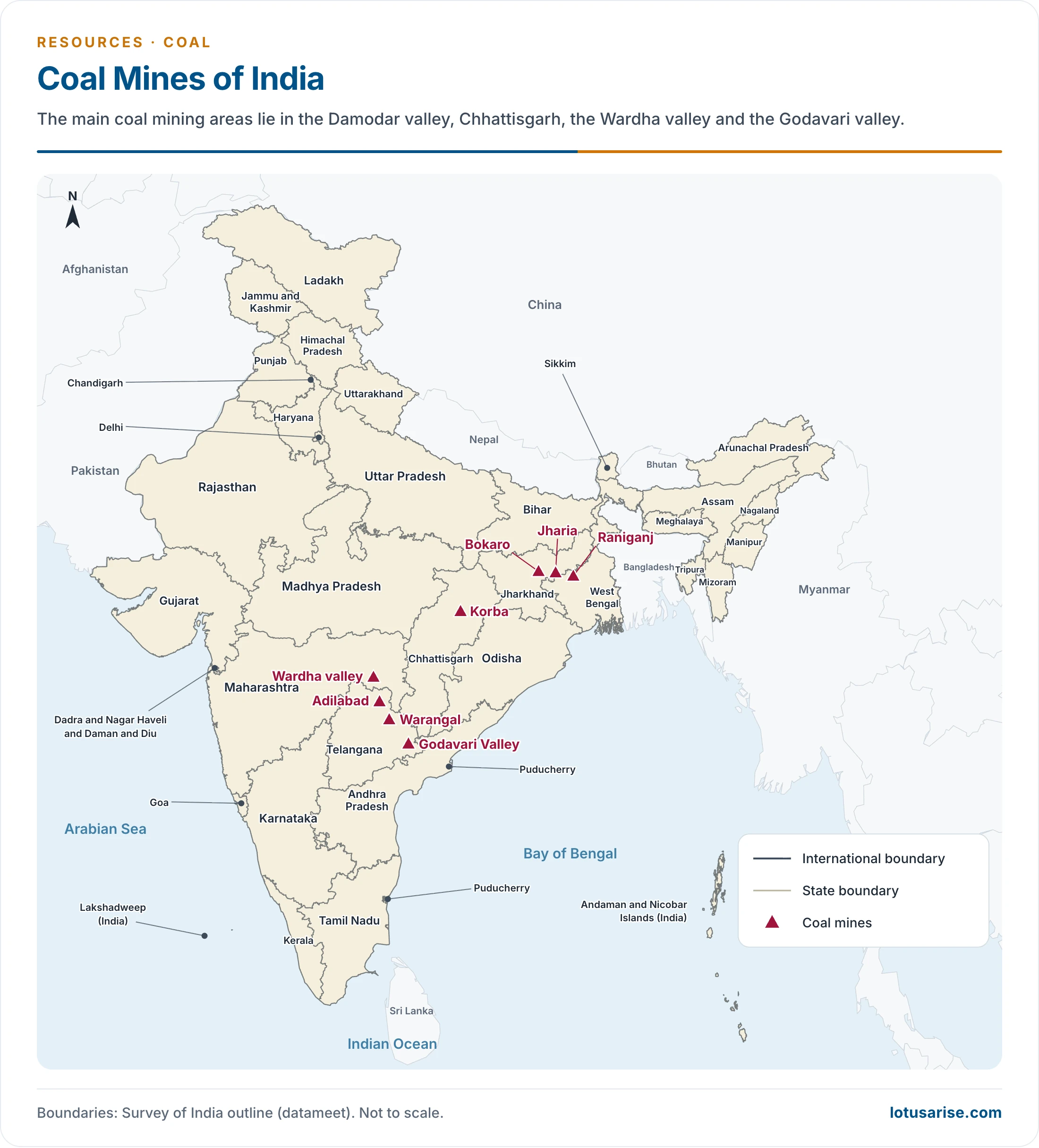
- Most fields lie east of 78°E. The densest cluster is the north-eastern Peninsula, across Jharkhand, Chhattisgarh, Odisha, eastern Madhya Pradesh and the adjoining part of West Bengal.
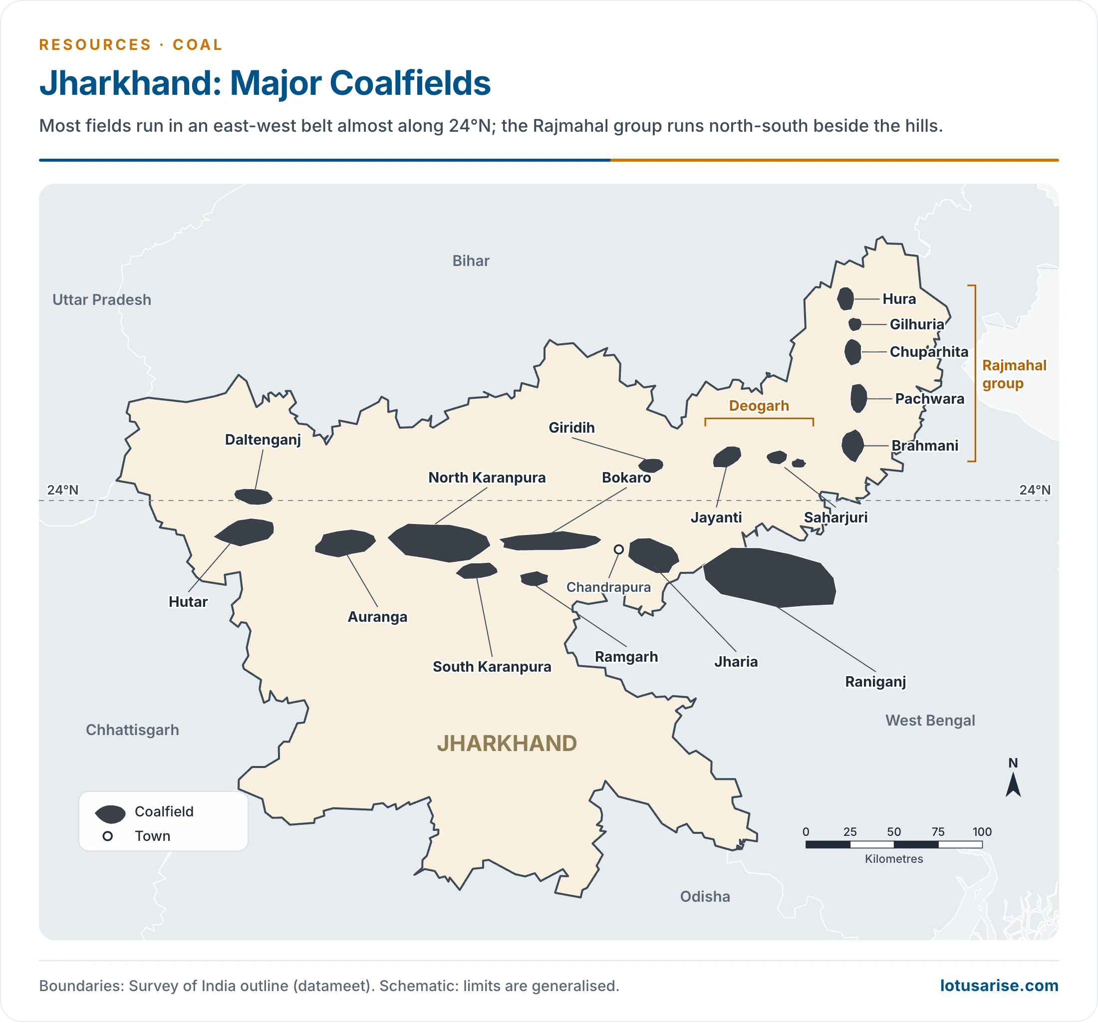
Jharkhand
- Second in both reserves and output now. It long led the country in output, and it led in reserves until recently.
- Most fields run in a narrow east-west belt almost along 24°N.
- It has 21 prominent fields: 8 in Dumka (Santhal Parganas), 7 in Hazaribagh, and 3 each in Dhanbad and Palamu.
| Field | Location and size | Older reserves (million tonnes) | 1 April 2025 (million tonnes) | Features |
|---|---|---|---|---|
| Jharia | South-west of Dhanbad; 453 sq km | 16,985.69 | 19,829.68 | Among the oldest and richest; best metallurgical coal |
| Bokaro | Hazaribagh district in older accounts; within 32 km of western Jharia; 674 sq km | West 4,473.73; East 4,246.32 | West 5,218.39; East 8,291.73 | Long, narrow strip in the Bokaro catchment |
| Giridih (Karharbari) | South-west of Giridih town, in older Hazaribagh district; 28.5 sq km | – | – | Lower Karharbari, Upper Karharbari and Badhua seams |
| North Karanpura | West of Bokaro; 1,230 sq km | 13,110.84 | 21,353.99 | Inferior coal; coal-bed methane |
| South Karanpura | West of Bokaro; 194 sq km | 5,757.85 | 8,394.21 | As above |
| Ramgarh | About 9 km south of Bokaro; 98 sq km | 1,059.20 | 1,906.47 | 22 seams |
| Daltenganj | Palamau; 51 sq km | 84 proved | 143.96 | Gondwana bituminous; 14 seams near Rajhera |
| Auranga | Palamu; 240 sq km | – | 4,190.00 | Inferior; cement furnaces, brick kilns |
| Hutar | Palamu; about 200 sq km | – | 249.82 | 5 inferior seams |
| Deogarh | Dumka; Jayanti, Saharjuri, Kundithuraih | – | 399.84 | Inferior, high ash |
| Rajmahal | Western side of the hills; 182 sq km | 1,913 proved | 20,837.28 | Hura, Gilhuria, Chuparhita, Pachwara |
- Jharia coal goes to Jamshedpur, IISCO, Bokaro and Rourkela.
- Giridih’s Lower Karharbari seam, 3–7.5 m thick, yields some of India’s finest coking coal.
- ONGC identified good coal-bed methane in the Karanpura fields, and methane now links coal with natural gas supply.
Chhattisgarh
- Third in reserves and third in output in 2024-25, at 85.26 billion tonnes and 204.95 million tonnes.
- Older accounts place it second to Jharkhand in output, and it led the country in 2011-12 with over 21%.
- Most of its fields lie in the north of the State. The largest resource is Mand-Raigarh, at 52.39 billion tonnes.
| Field | Location and size | Older reserves (million tonnes) | Features |
|---|---|---|---|
| Korba | Korba district; Hasdo valley, tributary of the Mahanadi, with the Ahram and Kurang; 515 sq km | – | Barakar measures, 700 m thick; feeds Korba thermal plant, Bhilai steel plant |
| Bisrampur | Surguja | 542 | Gondwana bituminous; seams 30 cm–1.8 m |
| Hasdo-Arand | Rampur in Surguja to Arand valley in Bilaspur; about 1,004 sq km | 4,321 | Seams 2.5–7 m |
| Chirmiri | Northern Surguja; 128 sq km | 362 | 4 seams, 3 of good quality |
| Lakhanpur | South of Bisrampur | – | Seams 1–3 m |
| Jhilmili | Koriya, north-west of the State; 106 sq km | – | Extension of Sohagpur; 5 seams of Talcher and Barakar measures; non-coking, high ash |
| Sonhat | Surguja region | – | High-quality coal |
| Tatapani-Ramkola | North-eastern Surguja, between the Kanhar and Rehar | – | Damuda series |
- Johilla lies in the valley of the Johilla, a tributary of the Son, and covers about 38 sq km with 311 million tonnes in older counts. It is usually listed with Chhattisgarh, but the national inventory places it in Madhya Pradesh, at 480.50 million tonnes.
- Kutkona, Charch and Sardih hold high-grade coal.
- Current resources (million tonnes): Korba 13,333.29; Tatapani-Ramkola 5,771.96; Hasdo-Arand 5,528.82; Sonhat 3,008.47; Bisrampur 2,697.64.
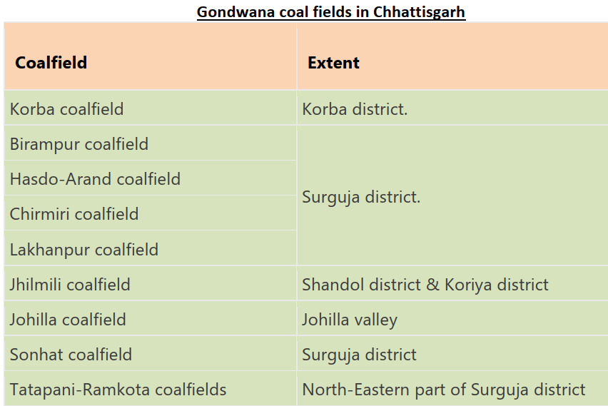
- Read “Birampur” as Bisrampur and “Shandol” as Shahdol. The inventory lists Johilla under Madhya Pradesh.
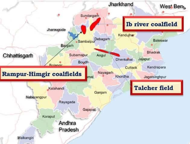
Odisha
- First in reserves and first in output now, with 100.98 billion tonnes and 269.36 million tonnes (25.71%).
- Older accounts rank it second in reserves and third in output, at 15.31%, later 19.54%.
- Deposits lie mostly in Dhenkanal, Sambalpur and Sundargarh districts.
- Talcher runs east from Talcher town to Rairkhol over 578 sq km.
- Older counts of 24,374 million tonnes ranked it second after Raniganj. At 56.82 billion tonnes it is now India’s largest coalfield by resource.
- Two workable seams, 3–4 m thick, were first proved over 295 sq km near the town.
- Its coal suits steam and gas, and mostly supplies thermal power and fertiliser plants at Talcher.
- Ib River spreads over 512 sq km of Sambalpur and Gangpur.
- Its seams, among them Rampur, Lajkuria and Gamhadera, lie in the middle and lower Barakar.
- Much of it is inferior, with about 50% fixed carbon.
- Older inferred reserves of 1,754 million tonnes have grown to 44.16 billion tonnes.
- Rampur-Himgir covers 520 sq km in Sambalpur and Sundargarh, within the Ib River system.
- It has middle and lower Barakar coal, mostly inferior.
- An older count gave it 30.48 million tonnes.
Madhya Pradesh
- Fourth in output, a place it has long held: 13.27% in 2011-12 and 16% (167.57 million tonnes) in 2024-25. It holds 8.38% of resources.
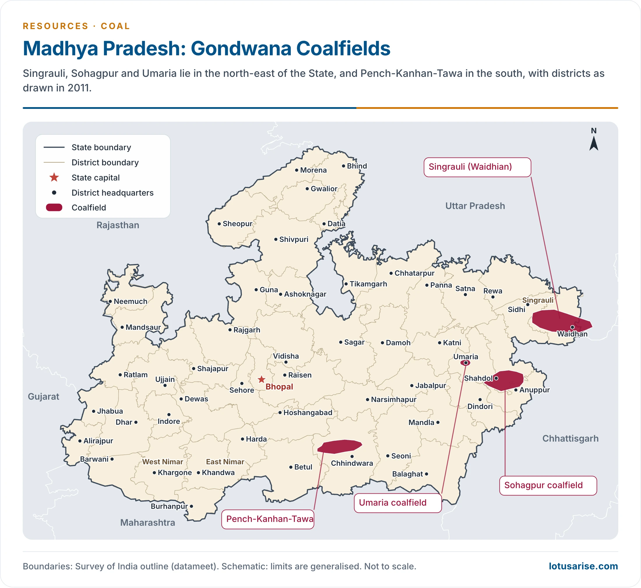
- Singrauli (Waidhian) is the State’s largest field, in Sidhi and Shahdol as older accounts place it.
- It covers 2,337 sq km and had 9,207 million tonnes in older counts, now 18,115.05 million tonnes in Madhya Pradesh and 1,061.80 in Uttar Pradesh.
- Seams include Panipahari, Khadia, Purewa and Turra.
- Jhingurda is its great seam, and it feeds thermal plants at Singrauli and Obra.
- At about 131 m, it is the thickest seam in India. Later research papers put it as high as about 165 m.
- Pench-Kanhan-Tawa (Chhindwara) has 1,956 million tonnes of semi-coking and non-coking coal in older counts, now 5,080.36. The Ghoravari seam, 4.6 m thick, holds coking coal.
- Sohagpur (Shahdol) had 2,284 million tonnes in older counts, now 9,113.36, in seams of 3–5 m and more.
- Umaria lies 58 km south of Katni, with 6 seams, 4 of them important, and 58 million tonnes. Its coal is poor, with high moisture and ash.
Andhra Pradesh and Telangana
- Older accounts give the undivided State 9.72% of India’s coal. Since 2014, Telangana holds most of it: 23.29 billion tonnes and 71.51 million tonnes of output, against 4.17 billion tonnes in Andhra Pradesh.
- Reserves lie in the Godavari valley, over 10,350 sq km, in Adilabad, Karimnagar, Warangal, Khammam, East Godavari and West Godavari districts as then drawn.
- Older estimates gave 10,435.50 million tonnes.
- Workable collieries: Tandur, Singareni and Kothagudem. Almost all of the coal is non-coking.
- These are the southernmost coalfields of India, and supply much of the south.
- Singareni lies 185 km east of Hyderabad, with 4 seams and 56.5% fixed carbon. The Regional Research Laboratory at Hyderabad has worked on improving the quality of this non-coking coal.
- Kothagudem, east of Singareni, has nine seams. Its Anandghani seam gives A-grade coal, used for thermal power.
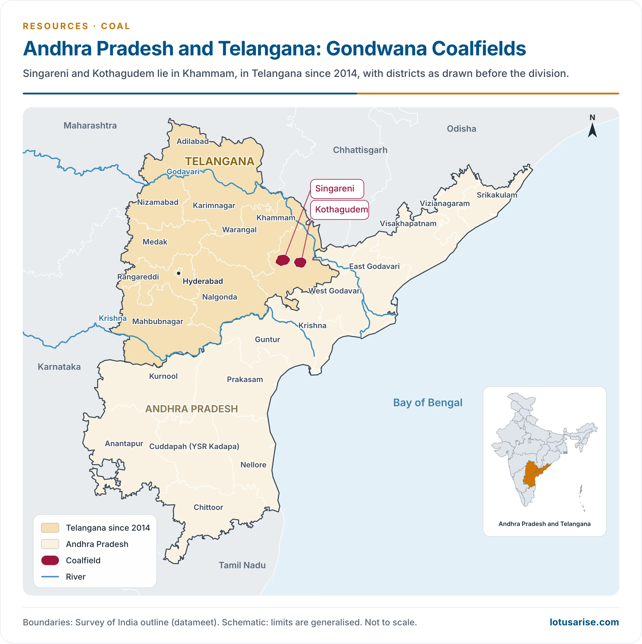
- Khammam, with Singareni and Kothagudem, has been in Telangana since 2014.
Maharashtra
- It has about 3% of reserves (now 3.39%). Its share of output has been put at over 9%, then over 7%, and was 6.76% in 2024-25.
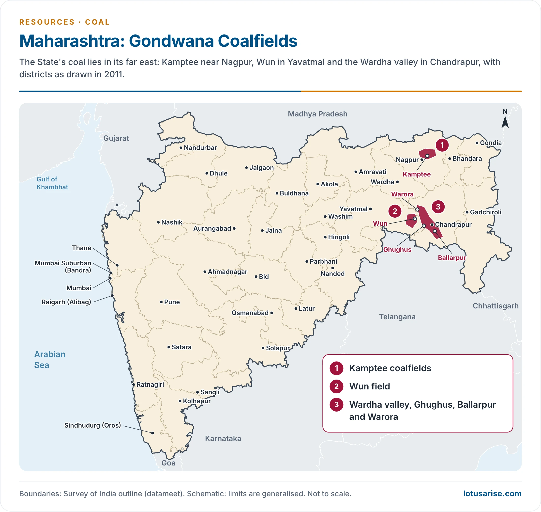
- Main fields:
- Kamptee in Nagpur district (3,258.19 million tonnes).
- Wardha valley with Ghughus, Ballarpur and Warora in Chandrapur district (8,424.07 million tonnes).
- Wun in Yavatmal district.
- Coal also occurs around Umrer, Nand, Makardhokra and Bokhara.
West Bengal
- It holds over 8% of resources (11% in older counts) but only 3.45% of output (6% in older accounts).
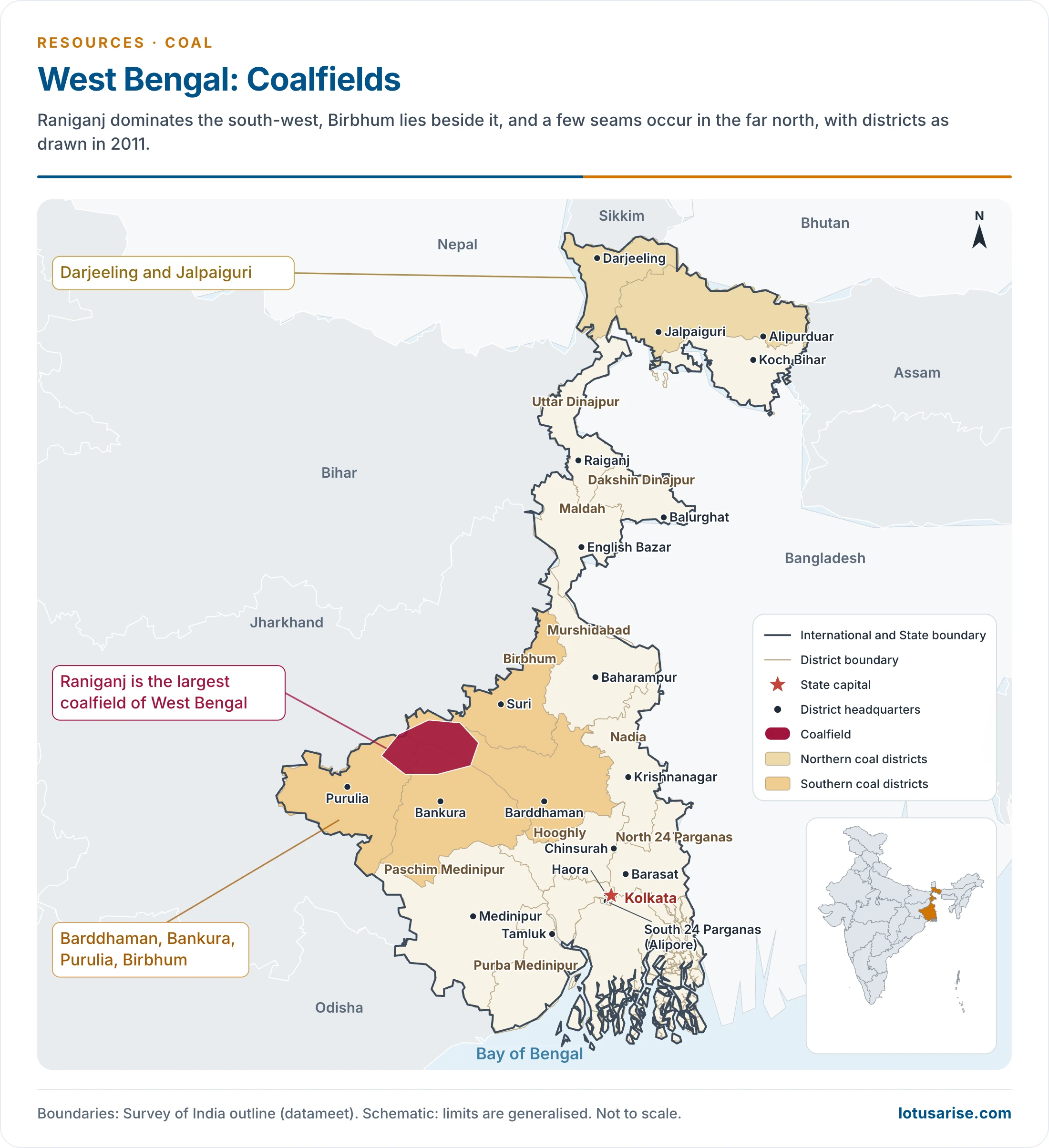
- Chief districts: Barddhaman (Burdwan), Bankura, Purulia, Birbhum, Darjeeling and Jalpaiguri.
- Raniganj is the State’s largest field and the birthplace of Indian coal mining in 1774.
- It covers about 1,500 sq km and continues the Jharia belt, with a small part in Jharkhand.
- It gives mainly non-coking steam coal for power stations.
- Resources stand at 26.39 billion tonnes in West Bengal and 2.44 billion tonnes in Jharkhand. Birbhum adds 7.78 billion tonnes.
- Darjeeling: the Dalingkot field, with a seam of about 3.3 m near Tindharia. Jalpaiguri: a few seams near the Duars.
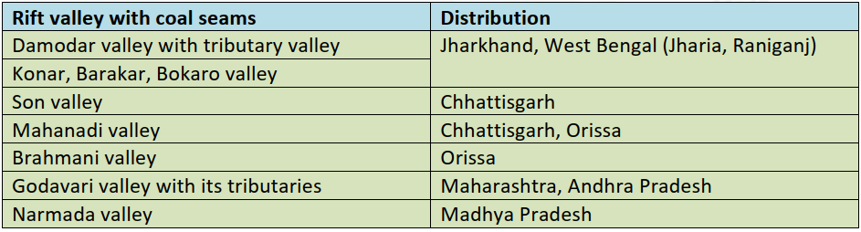
- On this table, Son valley coal lies largely in Madhya Pradesh as well as Chhattisgarh, and Godavari valley coal lies mainly in Telangana.
Uttar Pradesh
- Alluvium covers most of the State, which therefore has little coal. A small part of Singrauli crosses into it, with 1.06 billion tonnes.
Tertiary Coal
- It occurs with limestones and slates of Eocene or Oligocene-Miocene age, 15 to 60 million years old.
- Assam:
- Fields: Makum, Nazira, Mikir Hills, Dilli-Jeypore and Lakhuni, all but the Mikir Hills in the Upper Assam coal belt.
- Makum is the most developed, near Margherita, in what is now Tinsukia district. The field measures roughly 28 km by 5 km.
- Makum’s reserves: older count 235.6 million tonnes; 452.79 million tonnes in 2025.
- Nazira lies on the northern flank of the Naga-Patkai ranges, facing Sibsagar.
- Quality: the coal has very low ash and strong coking quality, but its high sulphur bars it from metallurgy. It suits hydrogenation into liquid fuel.
- Meghalaya:
- The Garo, Khasi and Jaintia hills hold Lower Eocene coal, with 583.22 million tonnes in 2025 (459 in older counts).
- Darrangiri lies in the Garo hills. Siju, Cherrapunji, Liotryngew, Maolong and Langrin lie in the Khasi and Jaintia hills.
- Rat-hole mining: the National Green Tribunal banned it in 2014, as unscientific and unsafe. At least 13 workers died at Ksan in East Jaintia Hills in 2018.
- Scientific mining began at Byndihati in East Jaintia Hills on 30 January 2025.
- Arunachal Pradesh:
- The Upper Assam belt runs east as Namchik-Namphuk (Namrup), in Changlang district, carved out of the older Tirap district.
- Seams are 4–19 m thick, high in volatiles and sulphur, with about 90 million tonnes.
- Nagaland holds 510.21 million tonnes, mostly inferred.
- Jammu and Kashmir:
- Kalakot, in Jammu Province, gives the country’s only anthracite, in small amounts. As in other Tertiary coals, angiosperm flora chiefly built its coal.
- Jangali, Chinkah, Metka, Maholgala and Ladde are other areas.
- Himachal Pradesh: Chamba district.
Lignite
- Output has grown sharply since Independence. National resources rose from 38.7 billion tonnes (2010), through an older 41.9 billion tonnes, to 47.37 billion tonnes (1 April 2025).
| State | Resources 2025 (million tonnes) | Share (%) | Output 2024-25 (million tonnes) | Output share (%) |
|---|---|---|---|---|
| Tamil Nadu | 37,523.65 | 79 (older count 90) | 21.96 | 48.66 (older figures 71, then 57.33) |
| Rajasthan | 6,661.17 | 14 | 9.88 | 21.88 |
| Gujarat | 2,722.05 | 6 | 13.30 | 29.47 |
| Puducherry | 416.61 | 0.9 | – | – |
| Jammu and Kashmir | 27.55 | – | – | – |
| Keralam | 9.65 | – | – | – |
| Odisha | 5.93 | – | – | – |
| West Bengal | 3.93 | – | – | – |
- Tamil Nadu:
- Neyveli in Cuddalore district is the most developed lignite field, over 480 sq km. It has 4,150 million tonnes in older counts, of which 2,360 million tonnes were proved.
- The wider Neyveli fields now total 8,912.99 million tonnes, enough for more than a hundred years of power generation on older estimates.
- Artesian water is a constant problem, and the mines need continuous pumping.
- NLC India Limited, formerly Neyveli Lignite Corporation (1956), works it, chiefly for thermal power.
- Mannargudi in Thanjavur and Thiruvarur actually holds more, at 24,693.90 million tonnes, though none of it is yet proved.
- Jayamkondacholapuram, older Trichy district and now Ariyalur, has 1,168 million tonnes in older counts, now 1,206.73.
- East of Veeranam is another important block.
- Gujarat: Kachchh at Umarsar, Lefsi, Jhalrai and Baranda, and also Bharuch. Umarsar gives the best lignite in the State.
- Rajasthan:
- Palana lies in Bikaner district. The deposit measures only about 4 km by 0.8 km, with seams 6–12 m thick lying 61–78 m down.
- The 250 MW lignite plant in Bikaner stands at Barsingsar, commissioned in 2010–11, with its own mine.
- Barmer added 1,640 million tonnes in a 2003 discovery.
- Jammu and Kashmir:
- Lignite of Pliocene or younger age occurs along the Shaliganga, and north-west to Nichahom in the Handwara area of Baramula district.
- It is of poor quality. Older counts give 90 million tonnes, while the 2025 inventory lists 27.55 million tonnes.
- Keralam: thin bands near Kannur and Kasaragod, plus Warkala, Paravur and Kozhikode.
- West Bengal: small pockets near the Jainti river in the north, in Darjeeling and Jalpaiguri, and beds in the Ganga delta.
- Puducherry: chiefly around Bahur.
Peat
- Peat occurs in only a few places:
- Nilgiri hills, above 1,800 m.
- Kashmir valley, in the Jhelum alluvium and in swampy higher valleys.
- Kolkata and its suburbs, in beds 2 to 11 m below ground.
- Ganga delta, in layers made of forest and rice plants.
Problems, Conservation and Use
Problems of Coal Mining
- Uneven distribution: the northern plains and western India have almost no coal, so a bulky commodity travels far. Long hauls raise costs for coal-using industries.
- Poor quality: high ash and low calorific value. Ash runs at 20–30% and can pass 40%, cutting energy output and creating a fly-ash disposal burden.
- Low underground productivity: older accounts describe a large share of coal as coming from underground, with underground mines using 80% of the manpower for 30% of the output.
- Underground output has since fallen to 3.04% (2024-25), but its productivity problem remains.
- Output per man-shift at Coal India in 2024-25: 1.31 tonnes underground, 23.50 tonnes opencast.
- Fires and theft: fires in mines and at pit heads, and pilferage along the way, cause heavy losses. Higher coal prices then feed a wider price spiral.
- Jharia is the classic case. The Cabinet approved a revised Jharia Master Plan of Rs 5,940.47 crore on 25 June 2025, for fire, subsidence and rehabilitation.
- Environmental damage: opencast mining leaves land rugged and ravined, and thermal plants release toxic gases.
- Health: coal dust in mines and around pit heads harms workers and their families.
- Cost of safeguards: pollution control is costly and complicated, beyond the means of ordinary small operators.
- Supply system: rail wagon shortages, power cuts and waterlogging in mines add to delays.
- Import dependence: coking coal is the main gap, as domestic reserves of it are limited.
Conservation of Coal
- Conservation means getting all the energy and every by-product that coal can yield, and building this into mine planning and operation.
- Why it matters: good coal gets wasted as ordinary fuel, metallurgical reserves are short-lived, and selective mining, fires and poor extraction waste the rest.
- Measures:
- Keep coking coal for metallurgy alone.
- Wash low-grade coal and blend it with better coal in set proportions for industry.
- Discourage selective mining, and take out all possible coal.
- Find new reserves and adopt new techniques.
- Amalgamate small, uneconomic collieries into viable units.
- Site thermal plants at pit heads, to cut the haulage of poor coal.
Coal and Thermal Power
- Coal’s main market is electricity: thermal power plants burn about three-quarters of all coal consumed.
- Installed capacity, 31 March 2026: coal 221,940 MW and lignite 6,620 MW, about 42.9% of the total 532,740 MW. Thermal stations, including gas and diesel, gave 77.01% of generation in 2024-25.
- Location: plants cluster either at the pit head (Singrauli, Korba, Talcher, Neyveli) or near markets and ports. Coal moves long distances to the second group, and this mismatch is the core problem of siting.
- Coal’s future in India’s energy mix is tied to the wider energy transition and to the energy crisis.
Previous Year Questions
2021Discuss the reserves, distribution and production of all varieties of coal in India.2014Location of thermal power plants and coal fields in India are not mutually conducive. Analyse.2014Discuss environmental and economic problems associated with coal production.2013Delineate the coalfields of India and mention their distinctive features.1995Examine the fossil fuel resources of India with particular reference to the present and future demands for energy.1990Assess the fossil fuel reserves of India in terms of current and future demands for energy. Examine the present and future and prospects of their utilization.1988Discuss the utilization and conservation of coal of India resources.





 History Optional PYQ Master Pack: Topic-wise Model Answers (1985–2025) by LotusArise IAS
 History Optional Mains Master Kit 2027 Complete Self-Study System — Notes, Mapping & Premium Articles by LotusArise IAS
Valueble… addition
Amazing content..thnq
Best content
very informative..thankyou
no!1
Best content
Very useful content…
best diagram based content