

- An air mass is a very large body of air, usually 1,600 km or more across and several kilometres thick, whose temperature and humidity are nearly uniform horizontally at any given level.
- It forms when air stagnates over an extensive, uniform surface (a warm ocean, a snowfield, a hot desert) long enough to reach equilibrium with it; that surface is its source region.
- When it moves away, it carries these properties with it, so the advance, modification and clash of air masses produce most day-to-day weather changes, especially in the middle latitudes.
- The concept was developed by the Bergen school of Norwegian meteorologists led by Vilhelm Bjerknes and his son Jacob Bjerknes around the end of World War I, and was turned into a working method of air mass analysis by the Swedish meteorologist Tor Bergeron (1928).
Air Mass: Meaning and Characteristics
Properties of an Air Mass
- Horizontal homogeneity: an air mass may stretch through 20° or more of latitude and cover hundreds of thousands to millions of km², so it is never perfectly uniform, but differences within it are small compared with the sharp changes across its boundaries (fronts).
- Two properties decide its weather:
- the vertical distribution of temperature, which shows whether it is warm or cold and whether it is stable or unstable
- its moisture content, which decides whether clouds and precipitation can form
- Conservation aloft: after leaving its source, an air mass keeps its original properties longest in its upper layers, because conduction is slow, stable air has little convection, and radiation acts weakly in clear air.
- Air mass weather: a region under one air mass sees broadly similar weather for several days; the weather changes abruptly when a different air mass arrives.
- Depth: cold continental air masses are often only 1–3 km deep, while warm maritime air masses may extend through the whole troposphere.
Role in the Atmosphere
- Air masses are an inseparable part of the planetary wind system: tropical air masses lie in the trade wind belts, while polar and tropical air meet in the westerlies along the polar front.
- They act as giant streams that carry sensible and latent heat poleward, helping to remove the latitudinal imbalance in heat shown by the heat budget of the earth.
- They carry moisture from the oceans to the continents, where it falls as precipitation.
- Most migratory disturbances, including temperate cyclones, form along the zones of contact between unlike air masses, and their weather depends on the air masses involved.
Cold and Warm Air Masses
- The terms are relative to the surface beneath, not absolute:
- A cold air mass is colder than the surface it moves over. It is heated from below, its lapse rate steepens and it becomes unstable and turbulent, with cumuliform cloud and showers.
- A warm air mass is warmer than the surface below. It is cooled from below, a surface inversion forms and it becomes stable, with stratus, fog or drizzle at most.
- The same air mass can change label: warm air passing from a cold continent onto a warmer sea becomes a cold air mass, and air that is “cold” over hot land by day may be “warm” over the same land at night.
- Air masses of different density do not mix readily when they meet; they keep their identity and are separated by a front.
Source Regions
Conditions for a Source Region
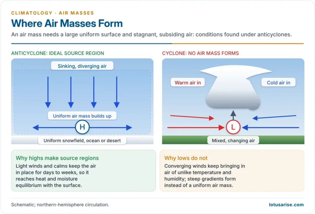
- An extensive, uniform surface: a large ocean, snow or ice sheet, plain, plateau or desert. Rugged relief or a mixed land–water surface is unsuitable.
- Stagnant, divergent air: the air must stay long enough (from two or three days to one or two weeks) to reach thermal and moisture equilibrium with the surface. This happens under slow-moving anticyclones with high pressure, weak pressure gradients, calms and light winds, where subsiding and diverging air keeps the column stable.
- Cyclonic areas are unsuitable: their converging winds keep importing air of different properties, so no uniform air mass can build up.
- For this reason there are no major source regions in the middle latitudes: the westerly belt is a zone of travelling cyclones and of contact between air masses, not a zone of stagnation.
Primary and Secondary Source Regions
- Primary source regions have stagnant air for long periods and fully transform it:
- the subtropical oceans under the semi-permanent highs (the Bermuda–Azores and Hawaiian highs)
- the hot deserts (the Sahara, Arabia, interior Australia)
- the snow-covered continental interiors of high latitudes in winter (Siberia, northern Canada) and the Arctic and Antarctic ice
- Secondary source regions have moving rather than stagnant air, but are large and distinctive enough to change passing air quickly:
- the North Pacific between Siberia and Canada and the North Atlantic between Canada and northern Europe, where cP air becomes mP
- the arid south-western United States
Source Regions by Latitude
| Source region | Location | Surface | Air mass produced |
|---|---|---|---|
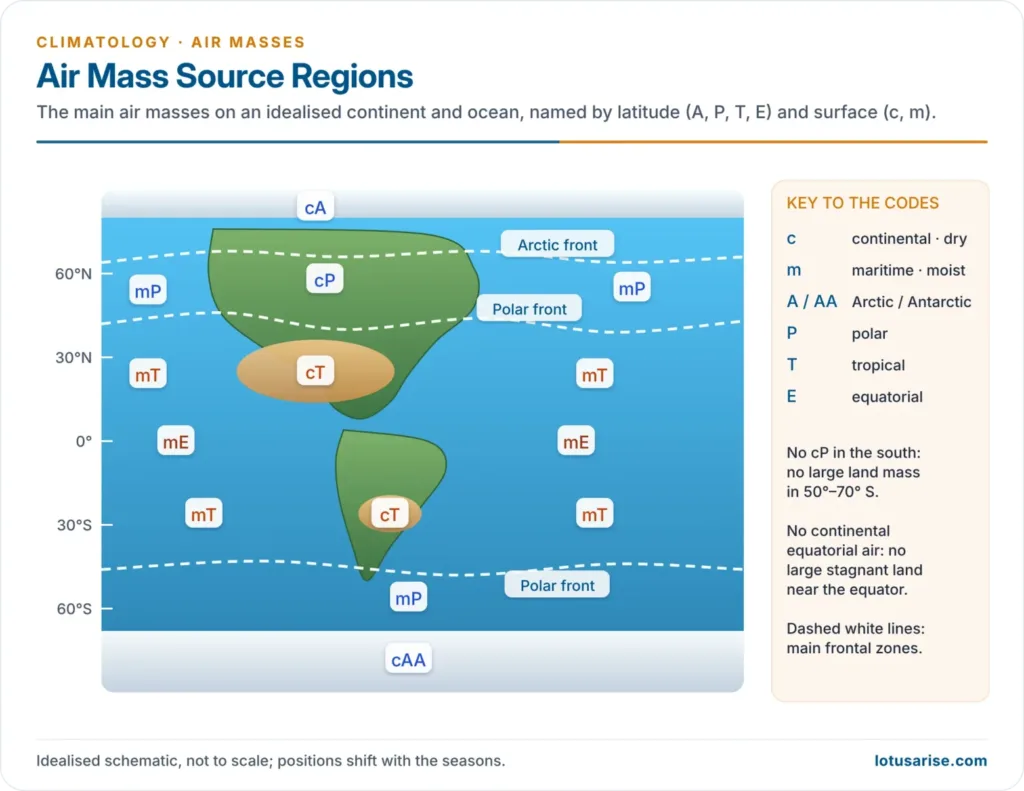
| Arctic / Antarctic | Permanent snow and ice of the polar basins and Antarctica | Ice | cA / cAA: the coldest, driest air |
| Polar | Between the Arctic source and the subtropical highs, about 50°–70° | Snowy continents; cool oceans | cP over land, mP over the oceans |
| Tropical | Subtropical high-pressure belt, about 20°–35° | Hot deserts; warm oceans | cT over land, mT over the oceans |
| Equatorial | Oceans near the equator, between the trades of the two hemispheres | Warm sea | mE: very warm, very moist |
Air Mass Modification
- As an air mass leaves its source, it modifies the weather of the regions it invades and is in turn modified by them. Warming or cooling from below, gain or loss of moisture, lifting or subsidence all change it.
- The degree of modification depends on:
- its initial properties (temperature, moisture, stability)
- the nature of the surface it crosses
- the path it follows (a maritime track adds moisture; a continental track keeps it dry)
- the time it takes to reach a place
- The two kinds of modification act separately or together.
Thermodynamic Modification
- It arises from heat and moisture exchange with the surface:
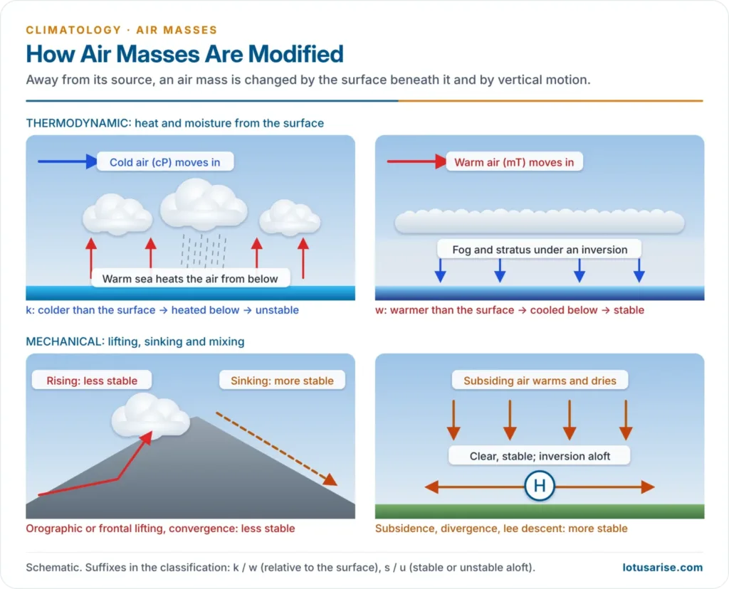
- Heating from below: a cold air mass over a warmer surface has its lapse rate steepened, becomes unstable, and produces cumulus, showers and squalls. Polar air masses moving equatorward are modified this way.
- Cooling from below: a warm air mass over a colder surface forms a surface inversion, becomes stable, and gives only fog, stratus and drizzle. Tropical air masses moving poleward are modified this way.
- Addition of moisture by evaporation from the sea, or by rain falling into drier lower layers, and loss of moisture by condensation and precipitation, with the latent heat gained or lost.
- The letters k and w record this relative temperature:
- k (kalt, cold): the air mass is colder than the surface and is being heated from below, so it tends towards instability.
- w (warm): the air mass is warmer than the surface and is being cooled from below, so it tends towards stability.
- Example: cold, dry, stable cP air from Siberia or Canada crossing the warm Kuroshio or Gulf Stream in winter is turned within a few days into moist, unstable mPk air with showers.
Mechanical (Dynamic) Modification
- It arises from vertical motion and mixing, independent of surface heating:
- Turbulent mixing by friction over rough ground spreads surface heat and moisture upward.
- Convergence and lifting (into a cyclone, up a front or over mountains) steepen the lapse rate and make the air less stable.
- Divergence and subsidence (in an anticyclone, or descending the lee of a mountain barrier) warm the air adiabatically and make it more stable and drier.
- Advection aloft: warm air arriving at upper levels stabilises an air mass; cold air arriving aloft destabilises it.
- The letters s and u record this upper-level state: s = stable aloft (common under anticyclones), u = unstable aloft (common in cyclonic regions).
Ocean Currents and Air Mass Behaviour
- Warm currents heat and moisten overlying air, making it unstable:
- Winter cP air over the Gulf Stream and Kuroshio becomes unstable mP air; this sharpens the temperature contrast off New England and Japan, which become breeding grounds of intense winter cyclones.
- The North Atlantic Drift keeps mP air reaching north-western Europe mild in winter.
- Cold currents cool overlying air from below, making it stable:
- Air over the California, Humboldt (Peru), Benguela and Canary currents develops inversions, advection fog and stratus, but little rain, which helps keep the Atacama, Namib and coastal Sahara deserts dry.
- Warm mT air moving over the cold Labrador current off Newfoundland produces the dense fogs of the Grand Banks.
Classification of Air Masses
Bergeron’s Classification
- Air masses are classified by two features of the source region:
- latitude, which sets temperature (capital letters): A Arctic or AA Antarctic, P polar, T tropical, E equatorial
- surface, which sets moisture (lower-case prefix): c continental (dry), m maritime (moist)
- The basic types: cA, cP, mP, cT, mT, mE. Continental equatorial air does not exist, because no large land surface near the equator has stagnant air.
- Modification suffixes are then added: k/w for the thermal relation to the surface and s/u for stability aloft. Combining cP, mP, cT, mT with k/w and s/u gives 16 types (cPks, cPku, cPws, cPwu, and so on).
- cPk is a cold, unstable continental polar air mass being heated from below; mTw is a warm, stable maritime tropical air mass being cooled from below.
- Other schemes grouped air masses differently: one recognised five classes (Arctic, Antarctic, polar, tropical and equatorial), another only three (Arctic, polar, tropical), and a two-class scheme kept only polar and tropical, treating Arctic and equatorial air as variants of these. The c–m and P–T framework is common to all and remains the standard.
Characteristics of the Main Air Masses
| Air mass | Source region | Properties at source | Typical weather where it goes |
|---|---|---|---|
| cA / cAA | Arctic Basin, Greenland ice cap, Antarctica | Extremely cold, very dry, very stable; strong inversion | Severe cold waves, clear skies |
| cP | Siberia, Mongolia, northern Canada and Alaska (winter) | Cold, dry, stable | Cold waves; clear, frosty weather; lake-effect snow after crossing warm water |
| mP | North Pacific and North Atlantic, 40°–60°; Southern Ocean | Cool, moist, conditionally unstable | Cloud, showers, snow showers; heavy precipitation where lifted over mountains or fronts |
| cT | Sahara, Arabia, Thar, interior Australia, northern Mexico | Hot, very dry; unstable near the ground but stable aloft | Heat waves, dust, drought; seldom spreads far from its source |
| mT | Subtropical oceans (Gulf of Mexico–Caribbean, Bermuda–Azores, Hawaiian highs) | Warm, very moist, unstable when heated | Muggy heat, cumulus and thunderstorms in summer; advection fog and drizzle when cooled in winter |
| mE | Equatorial oceans | Very warm, saturated, highly unstable | Heavy convectional rain; feeds the monsoons |
- Seasonal contrasts:
- Winter cP is the coldest air on earth outside the ice caps; it is cloudless at source, and becomes cPk with stratocumulus once over warmer ground or water.
- Summer cP is cool and dry but less stable, because the snow cover melts and the ground heats it; over the cool sea it becomes cPw with haze, fog and low stratus.
- Winter mP is cool and moist with moist, unstable lower layers, giving showery, squally weather; summer mP is cool and moist below, dry aloft, often with an inversion and a stable lower layer.
- mT is unstable throughout in summer, with moisture carried to great heights; when lifted over fronts or mountains it gives heavy precipitation.
- cT is dry in both seasons; when cT air overrides moist mT air, the column becomes convectively unstable and violent thunderstorms and tornadoes follow, as in the American Great Plains.
cP Air Masses and Global Climate
- Cold waves: outbreaks of cP air, often behind a temperate cyclone and steered by a deep upper trough, carry Arctic cold deep into the middle and subtropical latitudes.
- In February 2021, an Arctic outbreak plunged Texas into sub-zero temperatures and caused the failure of its power grid; Texas later put the death toll at 246.
- Cold anticyclones carrying cP air into the US Gulf states are called northers.
- Winter monsoon of East Asia: the Siberian High sends cold surges of cP air over China, Korea and Japan; the air picks up moisture over the Sea of Japan and dumps heavy snow on the west coast of Japan.
- Lake-effect snow: cP air crossing the unfrozen Great Lakes becomes cPk, very moist and unstable, and buries their southern and eastern shores in snow.
- Source of mP air: cP air pushed over the oceans becomes mP, completing a cP → mP → cP cycle that shapes the climate of the west coasts of North America and Europe.
- Fuel for cyclones: the contrast between cP and mT air along the polar front generates the temperate cyclones that bring most of the rain and snow of the middle latitudes.
- Heat balance: by flowing equatorward and being warmed, cP air carries cold southward just as mT air carries heat northward, part of the atmosphere’s meridional heat exchange.
Regional Air Masses
North America
- Its triangular shape, broad in the north and narrow in the south, and its north–south mountain ranges let polar and tropical air sweep across the Great Plains, making it an ideal arena for air mass contrasts.
- cP and cA: form over the snowy interior of Canada and Alaska and the Arctic Basin, and enter the United States between the Rockies and the Great Lakes as cold polar anticyclones.
- Crossing the Great Lakes they become moist and unstable (cPk), giving lake-effect snow; forced up the Appalachians, they give snow on the western slopes and descend warmer and drier on the east.
- mP Pacific: the most important mP air for the continent, because the westerlies carry it onshore. It brings winter rain to the coast and snow to the mountains, and descends east of the Rockies much drier.
- mP Atlantic: affects only the coast east of the Appalachians and north of Cape Hatteras. Drawn in by winter cyclones, it brings the cold, wet northeaster (nor’easter).
- mT Gulf–Caribbean–Atlantic: the main source of precipitation in the eastern and central United States; it makes summers oppressively humid and brings thunderstorms. In winter, cooled over cold ground, it gives advection fog and frontal rain.
- mT Pacific: in summer, moist air from the tropical Pacific west of Mexico flows north up the Gulf of California into the south-west, a monsoon-type circulation.
- cT: has only a small source region in northern Mexico and the south-west in summer, because the continent narrows southward; it is hot and dry and can cause drought if it persists.
Europe
- Europe has no real source region of its own; most of it is a zone of transition where air masses from elsewhere are transformed.
- Its mountain ranges run east–west (the Pyrenees, Alps, Caucasus), so maritime air from the Atlantic penetrates deep inland and keeps its character longer than in North America, where the ranges lie across the westerlies.
- mP Atlantic: dominant in western Europe.
- Air arriving by a short route from the Greenland–Spitsbergen area is cold and unstable, with gusty winds and snow showers.
- Air arriving by a longer, more southerly route is milder and nearly neutral, giving stratus and drizzle.
- mT from the Azores High: warm, moist and stable in its lower layers after cooling over the sea, with stratus and drizzle; it fills the warm sectors of the cyclones crossing western Europe.
- cP from Russia and Scandinavia: brings the severest winter cold to central and western Europe, mostly in the rear of cyclones or under blocking highs, as in the cold outbreak of late February–early March 2018.
- cT from the Sahara and south-west Asia: crosses the Mediterranean as the hot sirocco, turning humid and sultry over the sea; in summer it brings heat waves to southern Europe.
Asia
- Spanning the polar to the equatorial latitudes, Asia produces both the coldest and the hottest air masses on earth.
- cP: forms over central-eastern Siberia and Mongolia under the winter Siberian High, with surface temperatures near –40 °C and a persistent inversion.
- It spreads over eastern Asia as the winter monsoon.
- The Himalaya and the Tibetan Plateau block it from the Indian subcontinent; only modified cP air enters from the north-west, behind winter disturbances.
- mP: forms over the Sea of Okhotsk and affects the coasts of Siberia, Manchuria, Korea and northern Japan. In early summer it meets mT air over Japan and China along the Baiu (Meiyu) front, bringing the overcast, rainy season of June–July.
- mT and mE: dominate South and South-east Asia in summer as the monsoon air streams; even slight lifting over mountains or into depressions produces torrential rain.
- cT: forms over south-west Asia, Iran, Pakistan and the Thar in summer.
Air Masses Affecting India
- Winter (December–February):
- Modified cP air reaches north-west India behind the western disturbances, bringing cold waves and fog to the plains.
- The western disturbances themselves draw moist air from the Mediterranean, Caspian and Arabian Seas and give winter rain and Himalayan snow; when they fail, the winter turns dry, as in January 2024, when Himachal Pradesh recorded its driest January since 1901.
- The north-east winds blowing out of the continent are dry over land, but pick up moisture over the Bay of Bengal and give winter rain to Tamil Nadu.
- Hot season (March–May):
- cT air over the Thar, Baluchistan and the north-western plains brings the loo and heat waves; Churu recorded 50.5 °C on 28 May 2024.
- Where hot, dry north-westerly air overrides moist air from the Bay of Bengal, the column becomes unstable and the violent squalls of the Nor’westers (Kalbaisakhi) strike Bengal, Odisha and Assam.
- Summer monsoon (June–September): warm, moist mT and mE air from the southern Indian Ocean crosses the equator and recurves as the south-west monsoon, bringing most of the year’s rain to the Indian monsoon region.
Air Masses and Local Winds
- Many famous local winds are simply air masses on the move, shaped by relief and pressure systems:
- Mistral: cold, dry modified mP or cP air funnelled down the Rhône valley into the north-western Mediterranean behind cyclones.
- Bora: cold, dry modified cP air descending from the plateau to the Adriatic coast.
- Sirocco: hot, dry cT air from the Sahara drawn northward ahead of Mediterranean depressions; it reaches Sicily and southern Italy humid and enervating after its sea crossing.
- Norther: a cold cP outbreak sweeping south across the US Great Plains to the Gulf coast.
- Loo: the hot, dry cT air of north-western India in May and June.
- Their behaviour follows the air mass rules: cold air heated over warm water turns unstable (showery bora and mistral weather out at sea), and hot desert air cooled over the sea turns stable and humid (the sirocco’s sultry haze).
Previous Year Questions
2025Explain the relationship between air masses and local winds.2024Explain air masses and associated weather dynamics. How do air masses influence the weather conditions of the Northern Hemisphere?2022With suitable examples describe the impacts of the movement of air masses on weather and winds in different parts of the continents.2021What are the important factors responsible for airmass modifications?2017Discuss the impacts of ocean currents on air mass behaviour.2012Classify airmasses and explain how ‘cP’ airmasses affects global climate.2001Discuss the concept of air-masses and present their classification.1997Define air masses. How do they originate? Classify them and state the characteristics of any one type.1992Discuss the origin, movements and characteristic of air masses and explain their role in influencing world climates.1988Attempt a classification of air masses and give the characteristic features and associated weather conditions of each class.





Thank you very much ,you are doing a great job, very helpful
Most Welcome
You are great sir, please make a list of MCQ also for upsc.
Thank you for such beautiful notes.