

- Areal differentiation is the study of how the character of the earth’s surface varies from place to place, and of why each area comes to differ from its neighbours.
- It looks at physical and human phenomena together: relief, climate, soils, population, economy and culture. They are studied as they are linked to one another in the same place and to nearby places.
- The idea rests on a plain observation: no two places are identical. A model built for a plain will not serve a mountain valley, and a plan for a desert district will fail in a delta.
- It is the oldest line of geographical inquiry, the chorological or “area-studies” tradition. Richard Hartshorne made it the formal definition of geography in The Nature of Geography (1939).
- It gave regional geography its theoretical justification, lost ground to spatial science after 1953, and returned in a new form from the 1980s.
The Concept and Its Development

Meaning and Definition
- Hartshorne’s definition (1939): geography provides an “accurate, orderly and rational description and interpretation of the variable character of the earth surface”.
- Its aim is to interpret areal differences in two ways. One is the difference in particular things from place to place. The other is the total combination of phenomena in each place, which differs from every other place.
- Revised definition (1959): in Perspective on the Nature of Geography, he called geography the discipline that describes and interprets “the variable character of the earth’s surface as the world of man”.
- Chorology and chorography: both terms come from the Greek chōros (place). Chorology is the study of areal differentiation. Chorography is the description of particular regions.
- Idiographic character: because it stresses the unique and particular, areal differentiation is classed as idiographic. The opposite pole, the nomothetic or law-seeking view, searches for general laws.
- The phrase itself: “areal differentiation” was already current in American geography in the 1920s, as in the writing of Carl Ortwin Sauer. Hartshorne did not coin it. He made it the defining idea of the whole discipline.
- Place among the traditions: William D. Pattison’s “The Four Traditions of Geography” (1964) named a spatial, an area-studies, a man–land and an earth-science tradition. Areal differentiation is the area-studies tradition.
Core Premises
- Three premises underlie the concept:
- Interrelation: phenomena of many kinds are tied, directly or indirectly, to the earth’s surface and to one another.
- Differential character: these phenomena, and the complexes they form, differ from area to area.
- Areal expression: a phenomenon matters to geography only when it characterises an area of some definite extent, not merely because it exists.
- Selection by significance: geography does not study everything in an area. It selects phenomena by their contribution to the total differentiation of areas.
- Integration, not addition: other sciences study phenomena by classes, such as rocks, crops or prices. Geography studies how they are causally combined in particular places.
- It therefore cuts a section across the systematic sciences and borrows their generic concepts. It adds a point of view of its own, the areal.
- The region as the outcome: from areal differentiation comes the concept of the region. A region is an area that shows a defined degree of internal homogeneity and stands out from its surroundings.
- Hartshorne treated the region as an intellectual construct, not a concrete object found in nature.
- Regions may be formal (uniform), defined by sameness, or nodal (functional), organised around a centre.
- Integrating these elements into a picture of each region is the work of regional synthesis.
- Why study areas at all: people everywhere want to know what other parts of the world are like, and no other discipline answers that question.
- Sauer grounded geography in this common curiosity about areas.
- Paul Vidal de la Blache added that people do not live in “the world” but in limited areas. The world is therefore best understood area by area.
Sequential Development
Classical Roots
- Hecataeus of Miletus (6th century BCE) described the known world part by part in his Periodos Gēs (“Journey round the Earth”). This was the first regional survey of its kind.
- Strabo (c. 64 BCE–c. 24 CE) codified this tradition in the 17 books of his Geographica.
- For him the geographer was one who describes the parts of the earth. The two operative words, “describe” and “parts”, define chorography.
- His geography was practical and human-centred, meant for statesmen and commanders.
- Ptolemy (c. 150 CE) separated chorography, the detailed description of small areas, from geography, the mapping of the whole world.
Philosophical Foundation: Varenius and Kant
- Bernhard Varenius (Geographia Generalis, 1650) split the field into general geography (the whole earth) and special geography (particular regions). Special geography is the ancestor of the regional tradition.
- Immanuel Kant (1724–1804) gave the tradition its philosophical basis in his Königsberg lectures on physical geography (1756–1796).
- He distinguished logical classification, by kinds of things, which gives the systematic sciences, from physical classification, by time and place.
- History describes phenomena in time; geography describes them in space. Both stand apart from the sciences that study classes of objects.
- Later critics called this the root of geography’s “exceptionalism”.
The German Chorologists
- Alexander von Humboldt and Carl Ritter showed how things combine to fill an area and how these combinations change from place to place. Ritter’s regional, comparative method made the unity in diversity of regions central.
- Ferdinand von Richthofen (1883) defined geography as the study of the earth’s surface according to its differences in character from place to place. He called this the chorological viewpoint.
- Alfred Hettner (1859–1941) gave chorology its fullest form.
- He called geography the chorological science of the earth’s surface: the study of areas according to their causally related differences.
- In Die Geographie: ihre Geschichte, ihr Wesen und ihre Methoden (1927), he argued that reality must be seen from three viewpoints. These are the systematic (likeness of things), the historical (development in time) and the chorological (arrangement in space).
- His regional scheme ran in a cause-and-effect sequence: location, geology, relief, climate, resources, population, settlement, economy, transport and political divisions.
- He held that geography needs both the unique and the general: regional study must be lit by general concepts.
- Otto Schlüter (1906) shifted the focus to the visible landscape (Landschaft). He separated the natural landscape (Naturlandschaft) from the cultural landscape (Kulturlandschaft).
- Hettner stressed how a region reflected the physical earth. Schlüter stressed the interrelation of features that gave a region its distinctive look. Both were concerned with variation in the character of areas.
Hartshorne: The Formal Statement (1939)
- Hartshorne’s The Nature of Geography: A Critical Survey of Current Thought in the Light of the Past (1939) brought the German chorological tradition, especially Hettner, into the English-speaking world.
- It first appeared as a double issue of the Annals of the Association of American Geographers. For two decades it served as the discipline’s methodological charter in America.
- Main positions:
- Geography is the study of areal differentiation. Its highest expression is regional geography, which integrates what the systematic sciences study separately.
- Geography resembles history: history synthesises time sections of reality and geography synthesises space sections.
- Every area is a unique combination. Generalisation is possible only as generic concepts, and laws are hard to frame.
- Systematic (topical) studies supply the materials; regional synthesis is the goal.
- Time matters only to explain the present character of an area.
- The softened view of 1959: in Perspective on the Nature of Geography, Hartshorne denied any sharp systematic–regional dichotomy.
- He described a continuum that runs from topical studies of simple elements over large areas to regional studies of complex integrations in small areas.
- He accepted that geography seeks laws where it can, but held that law-making is a means, not the end of science.
- He set out four tasks for geography:
- Describe phenomena as accurately as possible, from observation independent of the observer.
- Classify them, as far as reality permits, by generic concepts.
- Analyse and synthesise them, using general principles or laws wherever possible, to understand the specific relationships in each area.
- Arrange the findings in orderly systems, so that what is known leads to the edge of the unknown.
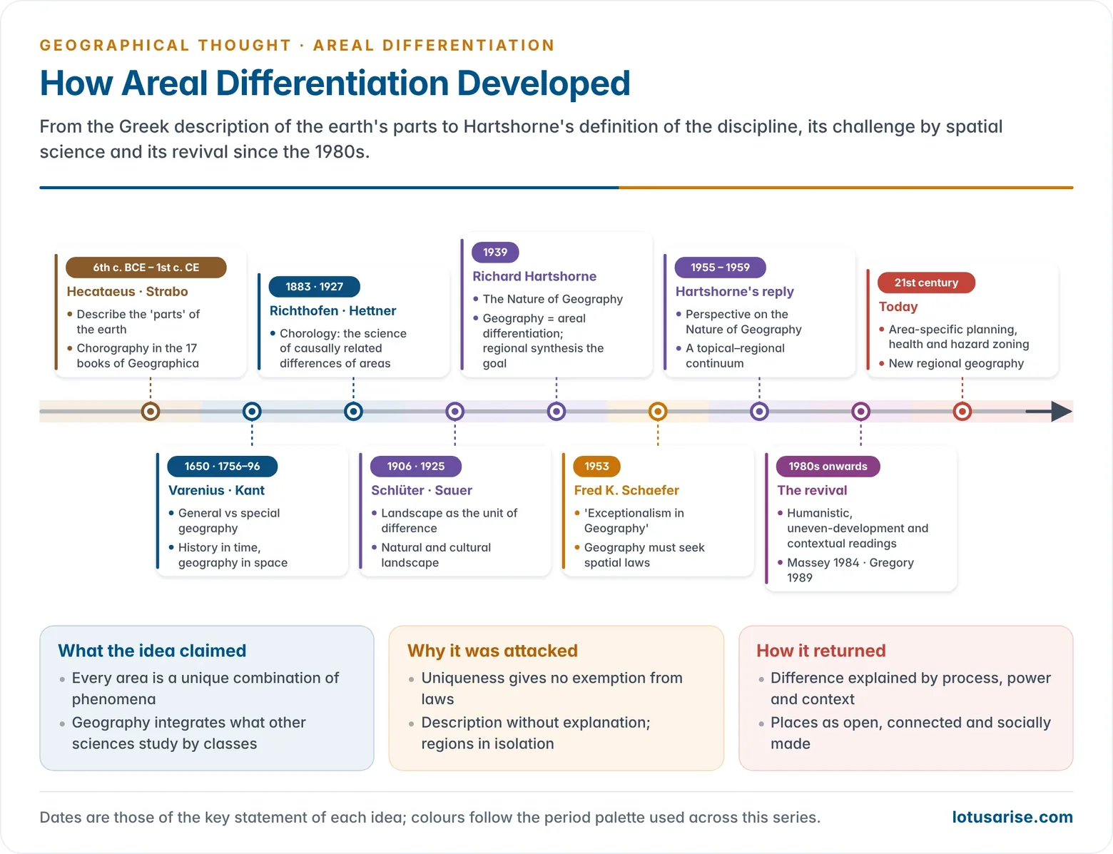
| Stage | Thinker and date | Contribution to areal differentiation |
|---|---|---|
| Classical | Hecataeus (6th c. BCE), Strabo (Geographica) | Description of the parts of the earth; chorography |
| Philosophical | Varenius (1650), Kant (1756–96) | Special geography; geography as the science of space |
| German chorology | Richthofen (1883), Hettner (1927) | Chorological science of causally related differences |
| Landscape school | Schlüter (1906), Sauer (1925) | Visible and cultural landscape as the unit of difference |
| Formal statement | Hartshorne (1939, 1959) | Areal differentiation as the definition of geography |
| Challenge | Schaefer (1953), Haggett (1965) | Exceptionalism rejected; spatial laws sought |
| Revival | Massey (1984), Gregory (1989) | Difference explained by process, context and power |
Methodology
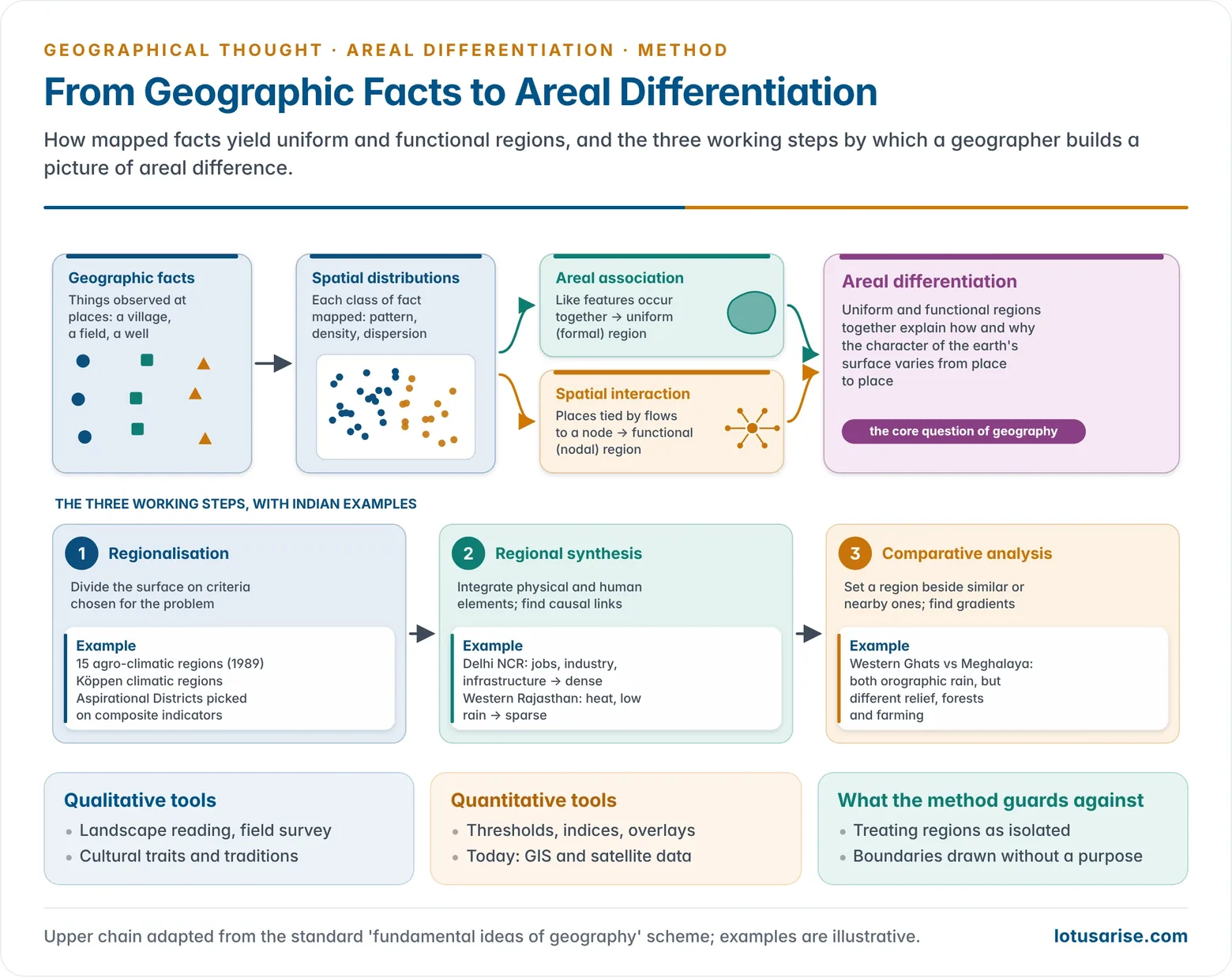
- Areal differentiation is carried out in three steps. They combine qualitative judgement with quantitative measurement.
- The logic behind the steps: individual geographic facts are mapped into spatial distributions.
- Similar distributions found together (areal association) define uniform regions.
- Distributions joined by movement (spatial interaction) define functional regions.
- The two kinds of region together explain areal differentiation.
Step 1: Regionalisation
- Regionalisation divides the earth’s surface into areas on the basis of selected criteria. It is geography’s own form of classification, a kind of areal generalisation.
- The criteria must suit the problem in hand. A region is “homogeneous” only with respect to the features chosen.
- Qualitative means include reading the landscape, cultural traits and traditions.
- Quantitative means include statistical thresholds, indices and cartographic overlays.
- Indian example: India’s climatic regions are drawn from mean temperature, rainfall and its seasonality, following Köppen’s scheme or Thornthwaite’s moisture index.
- The Planning Commission’s 15 agro-climatic regions (1989) combine climate, soil and terrain for farm planning.
Step 2: Regional Synthesis
- Regional synthesis integrates the physical and human elements of each region to find their causal links.
- The approach builds a single picture of the region’s personality.
- Example:
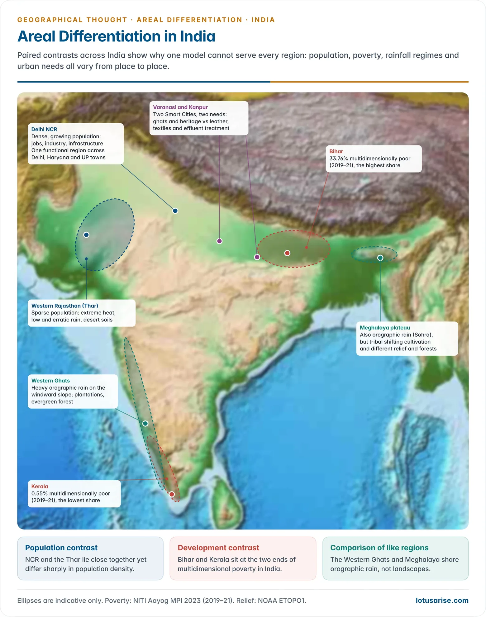
- Delhi NCR has a dense and growing population because of employment, industry, services and infrastructure.
- Western Rajasthan is thinly peopled because of extreme heat, low and erratic rainfall and desert soils.
Step 3: Comparative Analysis
- Comparison places a region beside proximate or similar regions. It reveals likenesses, differences, gradients and transition zones.
- Example: the Western Ghats and the Meghalaya plateau both receive heavy orographic rain. They differ, however, in relief, forest types, farming systems and culture.
- Comparison of this kind shows regional hierarchies and functional linkages, and keeps each region from being studied in isolation.
Critique, Decline and Revival
Schaefer’s Challenge and the Rise of Spatial Science
- Fred K. Schaefer’s “Exceptionalism in Geography: A Methodological Examination” (Annals of the AAG, 1953) attacked the Hettner–Hartshorne position. It was published after his death that year.
- He traced the claim that geography and history are methodologically exceptional back to Kant, and through Hettner to Hartshorne.
- All sciences deal with unique cases, he argued, yet they still seek laws. Uniqueness gives geography no special status.
- Geography should become the science of laws governing spatial arrangements, which he called morphological laws.
- The debate between Hartshorne and Schaefer shifted American geography towards the nomothetic, law-seeking approach.
- Through the 1950s and 1960s, the quantitative revolution shifted attention in several ways:
- from areal to spatial study;
- from absolute to relative location;
- from areal integration to spatial interaction, circulation and movement.
- Peter Haggett (Locational Analysis in Human Geography, 1965) and Richard Chorley charged that regional geography let areal differentiation crowd out the search for locational order, models and systems.
Other Criticisms
- Boundary problem: real boundaries are transitional and shifting, yet the method assumes regions can be neatly bounded.
- Semi-arid lands merge into arid ones. NCR keeps adding districts. The territories of social groups change with migration and mobility.
- No generalisation: case-by-case description yields no general theory, prediction or law. The output is an encyclopaedia of places.
- Description over explanation: Hartshorne’s “simple correlations” avoided causal mechanisms. Critics saw this as a retreat from theory after environmental determinism was discredited.
- Regions treated as isolated units: the method neglects flows and linkages.
- Delhi, Gurugram, Noida, Ghaziabad and Faridabad form one functional system and cannot be understood one by one.
- Static and present-bound: the method allowed time only to explain the present. Change and process were neglected.
- Totality over structure: stress on the whole region left little room to isolate causal factors or analyse underlying social and economic structures.
The Revival since the 1980s
- From the 1980s, areal differentiation was reinstated as a central perspective in human geography. The new support came from three directions that did not share the old vocabulary.
- Humanistic geography: this direction stresses human agency, consciousness and creativity.
- Its iconographic method reads the symbolic content of landscapes in their social and historical setting.
- Landscapes are seen as both shaped by and shaping wider cultural processes.
- Uneven development: Marxist and radical geography explain differences between places as products of capital accumulation and the spatial division of labour.
- Doreen Massey’s Spatial Divisions of Labour (1984) is a landmark of this line.
- Contextual theory: this line draws on structuration ideas. Place and region mediate between human agency and social structure, and so actively produce sameness and difference.
- Humanistic geography: this direction stresses human agency, consciousness and creativity.
- Postmodern sensitivity to difference: Derek Gregory’s essay “Areal Differentiation and Post-modern Human Geography” (1989) argued that attention to heterogeneity and particularity gives the old idea new life.
- What changed: the revived concept does not simply describe unique areas. It explains why places differ through process, power and connection.
- This is the ground of the new regional geography.
Main Reasons for the Revival
- Interdependence of physical and human phenomena: environments and ways of life are still region-specific. Equatorial, tundra and taiga societies show contrasting adaptations.
- Uneven development: inequality between and within countries demands area-based analysis.
- Internationally, the gap is between the Global North and South.
- Within India, Bihar had 33.76% of its people multidimensionally poor in 2019–21, against 0.55% in Kerala (NITI Aayog, 2023).
- Resource differences: iron ore in Chhattisgarh, Jharkhand, Odisha and Karnataka, but not in Kerala or Gujarat, shapes regional economies.
- Planning needs: identifying backward regions, the causes of underdevelopment and targeted strategies all start from areal difference.
- Social context: institutions differ by area, such as the joint family in rural India and the nuclear family in cities. They shape economic behaviour, political participation and identity.
| Basis | Classical areal differentiation | Spatial science | Revived areal differentiation |
|---|---|---|---|
| Period | 1900s–1950s | 1950s–1970s | 1980s onwards |
| Focus | Unique regions | Spatial laws and patterns | Why places differ |
| Method | Description, synthesis | Models, statistics | Process, context, critique |
| View of region | Bounded, given unit | Point in a spatial system | Social construct, open to flows |
| Key names | Hettner, Hartshorne | Schaefer, Haggett, Bunge | Massey, Gregory, Thrift |
Current Relevance
Regional and Resource Planning
- Region-specific programmes in India rest on areal differentiation:
- the Desert Development Programme for arid and semi-arid areas;
- the Border Area Development Programme;
- tribal sub-plans;
- the Aspirational Districts Programme (2018, 112 districts) and Aspirational Blocks Programme (2023, 500 blocks), which target the weakest areas on health, education, farming and infrastructure.
- Left-wing-extremism-affected areas: planning must read physical factors together with social ones.
- The physical factors are forested, hilly terrain and poor connectivity.
- The social factors are poverty, exclusion and weak governance.
- Agricultural zoning: agro-climatic zones, crop-suitability maps and irrigation planning all apply the method.
Health, Disaster and Urban Planning
- Health geography: disease risk varies with climate, vectors and urban density.
- During COVID-19, India graded districts into red, orange and green zones, a direct use of areal difference.
- Disaster risk: hazard zonation for earthquakes, floods and cyclones maps differential vulnerability.
- Smart Cities Mission (2015): a single template cannot fit every city.
- Varanasi, a religious and cultural city, needs ghat renewal, heritage conservation, support for its silk-weaving and services for pilgrims and tourists.
- Kanpur, an industrial city, needs freight transport, effluent treatment for its leather and textile units and industrial water management.
Globalisation and Inequality
- Globalisation has not made places alike. It re-sorts them. Capital, migrants and information concentrate in some regions and bypass others.
- Explaining this new unevenness requires a geography of difference.
- Scale: difference is now studied at several scales at once, from the global to the city block. Satellite data, GIS and big data let it be measured precisely.
- Synthesis: Haggett (Geography: A Modern Synthesis, 1972) placed regional complex analysis, which combines spatial and ecological analysis, alongside the other two approaches. This reconciles areal differentiation with spatial science.
Evaluation
- Lasting strengths:
- It keeps geography focused on the variable character of places and gives regional study a rational basis.
- It grounds area-specific planning.
- Lasting limits:
- Taken alone, it describes without explaining, and it struggles with boundaries, flows and change.
- Present position: areal differentiation survives as the core question of where and why places differ. It is now answered with the tools of spatial analysis and the insights of critical social theory.
Previous Year Questions
2023Explain the sequential development of areal differentiation as a fundamental concept in Human Geography.2018“Areal differentiation has provided the theoretical justification for studying ‘regions’ and regional geography.” Comment.2016“Areal differentiation forms the core theme in Geography.” Explain.2010Critically examine the changing perspectives on the concept of areal differentiation.2005Write short note: Areal differentiation.





Thanks guys it takes hours to get all such information…..
Thanks a lot
I believe there is a typo in the definition – I think it should be causally and not casually. Could you please confirm?
Yeah, Thanks
Sir,what is the meaning of QR
Quantitative Revolution
https://lotusarise.com/quantitative-revolution-in-geography-upsc/
Quantitative revolution
is there any answer writing initiative in geography optional. it will be helpful
No, Anthony
sir/madam My heartly and humble request with folded hands,pls post some questions that I can answer,and you can give guidance on it,I will be very gr8ful to u,gave 3 mains but due to geography,I missed all.thanks.
Arpit have you completed whole geography syllbus??
A1
Is there any any books, combined of all these geographical portions for optional ?
Actually these are good notes. Thank you for your efforts.
rd dixkhist
Mam,i think lotus arise pattern is 1000 times better than rd dicit sir.
https://store.lotusarise.com/
Very helpful
thanku ,thanku very much sir ,i dont have words to express my feelings.
The subject has become easy to understand.I really like the current updates with topics explained.
Thanks to all of you.
why people say that geography is not scoring subject ? sir
thank you so much …I think there is a typo in the last point of main reasons for revival of areal differentiation…in place of ‘portion’ it should be production…
very helpful for post graduation exams also
Please how can one argue or draw emphasis that geography is the study of Areal Differentiation?
Enlightened
Great website. I am referring it for my pg exam. Also preparing for upsc with geography optional. Great for quick revision. Also very well organized content.
respected madam…….how can i download this pdf
…
Download from Store website: https://store.lotusarise.com/
Hello sir..
Can u please tell me how to prepare for human geography. just general views on that and how to use books for it….I’ve completed physical geography …By self study and also ur websites and these notes helped me a lot in completing physical geography…But I’m getting difficulty in human geography…..I’m following certain books of majid hussain. ….And just started the prep. BUt not getting anything ….Physical was lil easy ..
Thanks a lot sir!
Your notes are really helpful.