

- Town planning is the deliberate organisation of land, buildings, circulation and services in a town so that it grows in a healthy, convenient, efficient and attractive way.
- India has one of the oldest traditions of planned towns, from the Harappan grids to Jaipur. In the twentieth century it added colonial improvement trusts, post-independence new towns, statutory master plans and, since 2015, mission-led programmes such as the Smart Cities Mission.
- The gap between plans and reality is wide. Most of India’s urban growth still happens outside any plan.
Concept of Town Planning

Meaning and Aims
- Town planning is multidisciplinary: geographers, architects, engineers, economists, sociologists and administrators all contribute.
- Geography supplies the analysis of site, situation, land use and regional linkages.
- Classic definitions stress three ideas:
- Welfare of citizens and a higher standard of living.
- The use and development of land.
- Foresight: orderly development of a city and its surroundings on rational lines, with regard to health, amenity, convenience and economic progress.
- Aims:
- Health: clean air, water and sanitation, and noxious industry kept away from homes. Wind direction guides where factories go.
- Convenience: short, cheap journeys between home, work and services.
- Beauty: a pleasing townscape, open spaces and conserved heritage.
- Efficiency, equity and sustainability: the modern additions, which mean economic land use, housing for all classes and protection of natural systems.
Elements and Principles
- Elements of a town plan:
- Land use: residential, commercial, industrial, public and semi-public, recreational, agricultural and green.
- Circulation: a hierarchy of roads, public transport, parking, and pedestrian and cycle networks.
- Housing for all income groups, including slum upgrading.
- Physical infrastructure: water supply, sewerage, drainage, power and solid waste.
- Social infrastructure: schools, hospitals, markets and community centres.
- Open spaces and environment: parks, playgrounds, water bodies and green belts.
- Economic base: sites for industry, trade and offices.
- Principles:
- Zoning: separate incompatible uses (polluting industry from housing) and group complementary ones.
- Hierarchy of roads, from arterial roads to local streets, with through traffic kept out of neighbourhoods.
- Neighbourhood unit (Clarence Perry, 1929): a residential cell built around a primary school and local shops, within walking distance, and bounded by main roads.
- Green belts and open space to check sprawl and give recreation.
- Decentralisation through satellite towns and new towns.
- Provision for future growth: direction and limits of expansion fixed in advance.
- Urban renewal and conservation of old cores and heritage.
- Public participation in preparing and reviewing plans.
Approaches to Planning
- Comprehensive or master plan (blueprint) approach: a fixed end-state land-use plan for 20 years or so. It has been the backbone of Indian practice.
- Systems approach:
- The city is treated as a system of interacting activities, spaces and flows, to be modelled, monitored and steered continuously.
- This view was developed by J. Brian McLoughlin (1969) and George Chadwick (1971).
- It is strong in analysis and forecasting. It is criticised for data hunger, mechanistic assumptions and neglect of politics and values.
- Incremental and strategic planning:
- Flexible structure plans that set broad directions.
- Projects then take up the detail.
- Advocacy and participatory planning (Paul Davidoff, 1965): planners represent the interests of the poor and of communities, not only the State.
- Regional approach: a city is planned with its region, as in the National Capital Region or the metropolitan regions.
- New town approach: building complete towns on fresh sites.
- Land readjustment: town planning schemes (Gujarat and Maharashtra) and land pooling (Amaravati, Delhi). Owners give part of their land for roads and services and get back smaller, serviced plots.
- Transit-oriented and smart approaches: dense, mixed development around mass transit, and data-driven management of services.
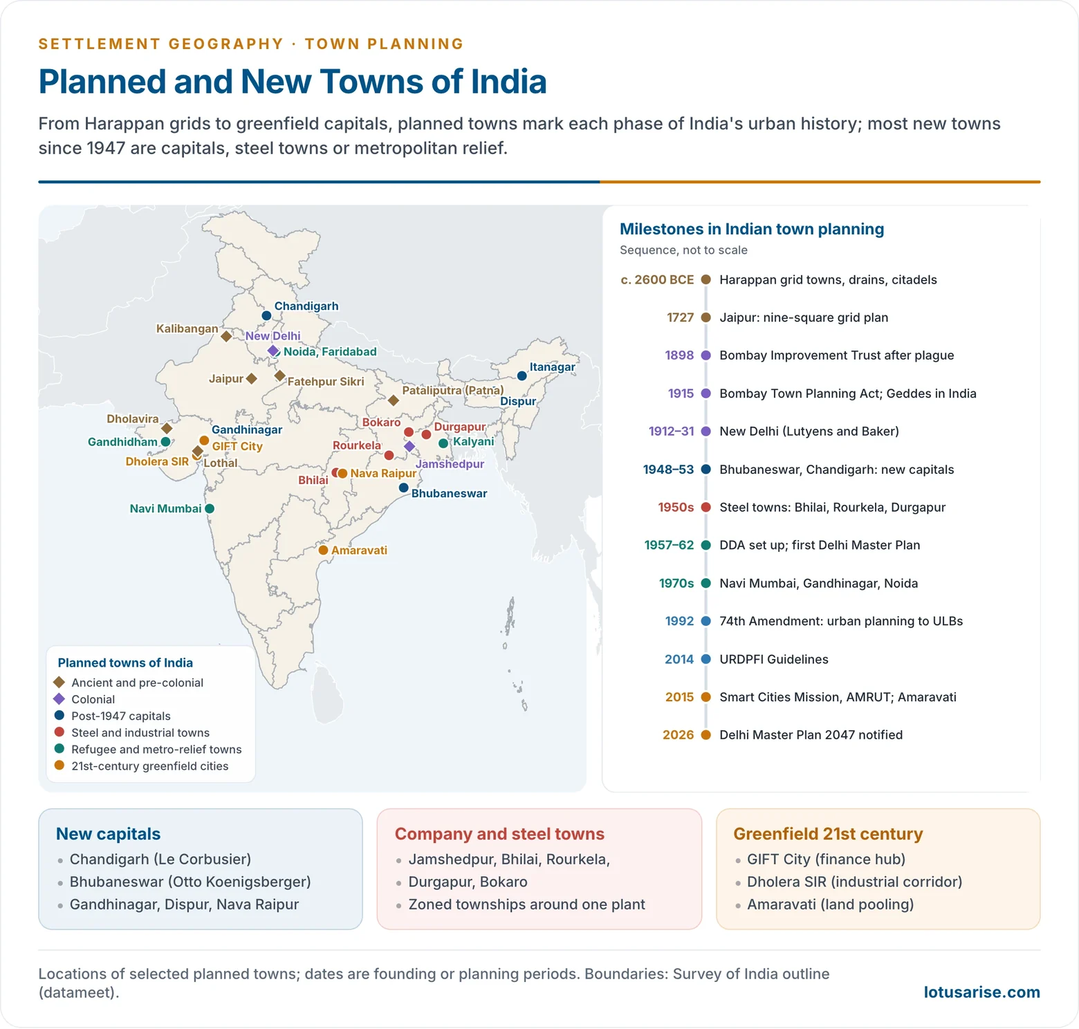
History of Town Planning in India
Ancient and Medieval Planning
- Harappan towns (c. 2600–1900 BCE) were laid out on a grid of main streets meeting at right angles.
- They had a raised citadel and a lower town, covered brick drains, standardised bricks and granaries.
- Examples are Mohenjo-daro and Harappa (now in Pakistan), and Dholavira, Lothal and Kalibangan in India. Dholavira was inscribed as a UNESCO World Heritage Site in 2021.
- Early historic period:
- The Arthashastra prescribes walls, gates, moats and zones for different occupations.
- Megasthenes described Pataliputra as a great walled city along the Ganga.
- Vastu and Shilpa texts (such as the Manasara) set out grid and concentric layouts.
- Temple towns such as Madurai grew in concentric squares around the temple.
- Mughal cities:
- Fatehpur Sikri (1571).
- Shahjahanabad (1648): a walled city on the Yamuna with Chandni Chowk as its axis and the Red Fort at its head.
- Jaipur (1727):
- Founded by Sawai Jai Singh II and planned with Vidyadhar Bhattacharya on a grid of blocks following Vastu principles.
- It has broad bazaar streets and is a UNESCO World Heritage city (2019).
Colonial Planning
- The British built cantonments and civil lines apart from the “native town”, giving the urban morphology of Indian cities its dual character.
- Improvement Trusts cleared congested areas and laid new roads after the plague:
- Bombay (1898), after the plague of 1896.
- Calcutta (1911).
- The Bombay Town Planning Act (1915), India’s first, introduced town planning schemes.
- Patrick Geddes worked in India from 1914 to 1924.
- He prepared reports on many towns, among them Indore (1918).
- He argued for diagnostic surveys and “conservative surgery”: careful improvement of old quarters in place of wholesale demolition.
- New Delhi was planned from 1912 by Edwin Lutyens and Herbert Baker as the imperial capital, with grand axes and roundabouts. It was inaugurated in 1931.
- Jamshedpur grew from 1907 around the Tata steel works as a planned company town.
After Independence
- Refugee towns after Partition: Faridabad (1949), Gandhidham, Rajpura, and model towns added to older cities.
- New capitals:
- Chandigarh, planned 1950–51 and inaugurated in 1953.
- Bhubaneswar (1948), planned by Otto Koenigsberger.
- Gandhinagar (capital from 1970), Dispur and Itanagar.
- Later, Nava Raipur (2000s) and Amaravati. Amaravati’s foundation was laid in 2015, works were relaunched in May 2025, and Parliament passed a law in April 2026 recognising it as Andhra Pradesh’s sole capital.
- Steel and industrial towns of the 1950s and 1960s: Bhilai, Rourkela, Durgapur, Bokaro, each with a zoned township beside the plant.
- Metropolitan relief towns: Navi Mumbai (CIDCO, from 1970), Salt Lake and New Town near Kolkata, and Noida (1976).
- Twenty-first-century greenfield projects:
- GIFT City (2007), a financial hub in Gujarat.
- Dholera Special Investment Region on the Delhi–Mumbai Industrial Corridor.
| New town | Planned | Purpose | Planner or agency |
|---|---|---|---|
| Bhubaneswar | 1948 | State capital (Odisha) | Otto Koenigsberger |
| Chandigarh | 1950–53 | State capital (Punjab, later also Haryana) | Albert Mayer; Le Corbusier and team |
| Bhilai | 1950s | Steel township | Bhilai Steel Plant |
| Gandhinagar | 1960s; capital 1970 | State capital (Gujarat) | H. K. Mewada and Prakash Apte |
| Navi Mumbai | from 1970 | Counter-magnet to Mumbai | CIDCO |
| Amaravati | from 2015 | State capital (Andhra Pradesh) | Land pooling; master plan prepared with Singapore |
- Institutions and law:
- The Delhi Development Act (1957) created the DDA. The Town and Country Planning Organisation (TCPO, 1962) advises the Centre.
- A Model Town and Country Planning Law (1960) led to State Acts, such as the Maharashtra Regional and Town Planning Act (1966).
- The 74th Constitutional Amendment (1992) placed urban planning, including town planning, and regulation of land use in the Twelfth Schedule for urban local bodies. It created District and Metropolitan Planning Committees, the urban arm of decentralised planning.
- Planning standards followed: the UDPFI Guidelines (1996), replaced by the URDPFI Guidelines (2014), and the Model Building Bye-Laws (2016).
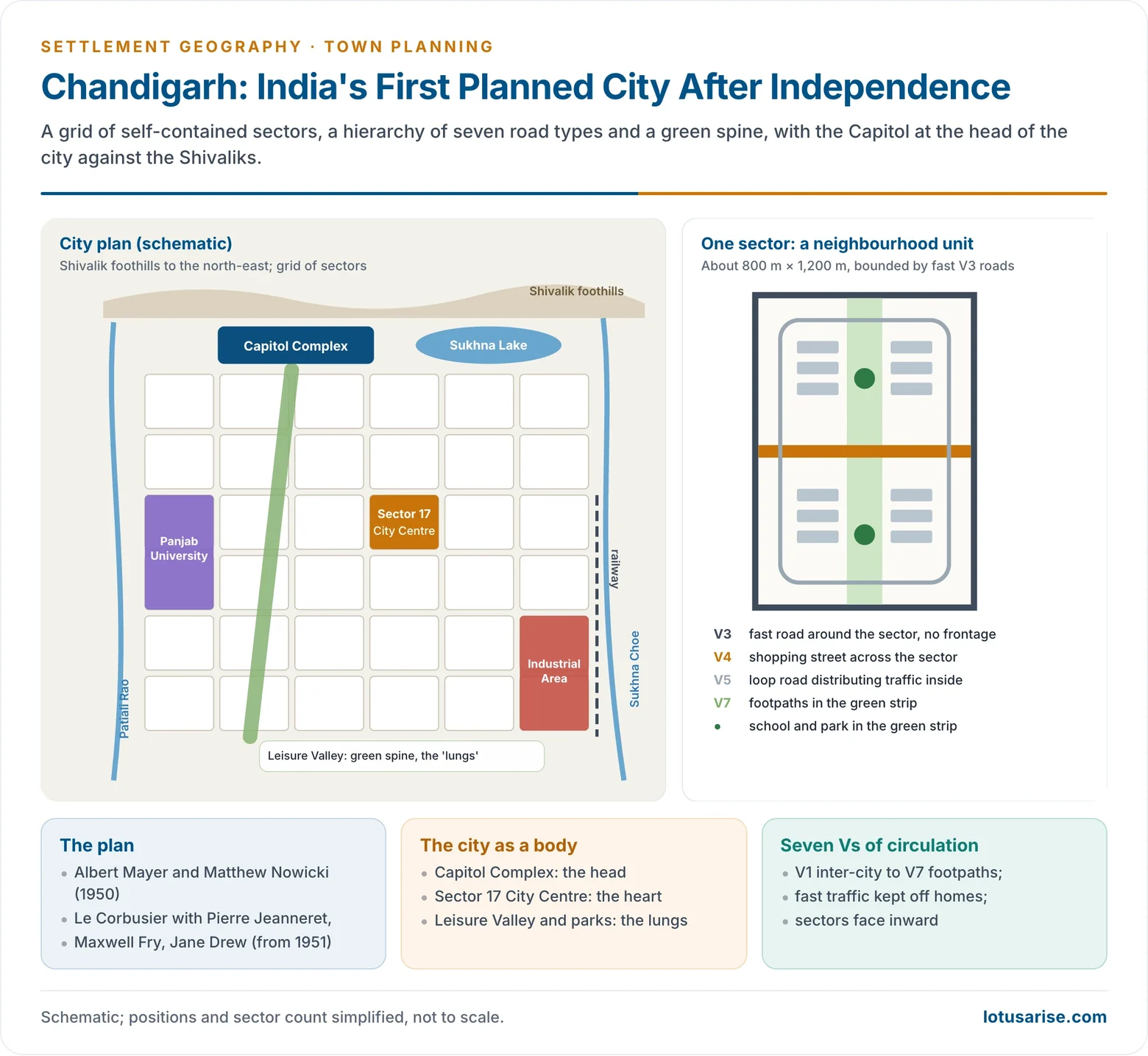
Chandigarh: The First Planned City of Independent India
- Need: Partition left Punjab without its capital, Lahore. A new capital was planned from 1950.
- Planners:
- The first plan was by Albert Mayer with Matthew Nowicki.
- After Nowicki’s death in 1950, Le Corbusier took over (1951) with Pierre Jeanneret, Maxwell Fry and Jane Drew.
- Site: a gently sloping plain at the foot of the Shivaliks, between two seasonal streams, the Patiali Rao and the Sukhna Choe.
- Features:
- A grid of sectors, each about 800 m × 1,200 m, designed as a self-contained neighbourhood. Each has a shopping street, schools, health centre and a north–south green strip.
- The “7 Vs”: a hierarchy of roads from V1 (inter-city) and V2 (arterial avenues) to V3 (fast roads around sectors, with no houses fronting them), V4 (shopping street), V5 (loop road), V6 (house access) and V7 (footpaths and cycle tracks in green belts).
- The city is designed like a body:
- The Capitol Complex (Secretariat, Assembly, High Court) is the head, at the northern edge against the hills.
- The Sector 17 City Centre is the heart.
- The Leisure Valley and parks are the lungs.
- The industrial area and railway lie to the south-east, downwind of homes. Sukhna Lake was made by damming the Sukhna Choe.
- A protected rural periphery (Periphery Control Act, 1952) was meant to stop sprawl.
- Outcome:
- Planned for about 1.5 lakh people in its first phase, the Union Territory had 10.55 lakh in 2011.
- Growth spilled into Panchkula and Mohali, forming a tricity, and the periphery has been encroached.
- The Capitol Complex is part of the UNESCO World Heritage listing of Le Corbusier’s architectural work (2016).
Master Plans
Nature and Preparation
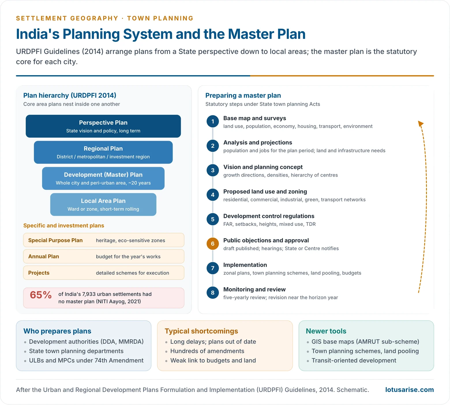
- A master plan (development plan) is a statutory, long-term plan for a whole city and its peri-urban area, usually for about 20 years. It allocates land to uses, fixes densities, and plans roads, utilities and services.
- URDPFI (2014) sets out a hierarchy of plans:
- A Perspective Plan for the State.
- Regional Plans for districts, metropolitan regions and investment regions.
- Development Plans for cities.
- Local Area Plans for zones.
- Special Purpose Plans, Annual Plans and projects for execution.
- Steps in preparing a master plan:
- Base map and surveys.
- Analysis and projections.
- Vision and concept.
- Proposed land use and zoning, and development control regulations (floor area ratio, setbacks, heights).
- Publication of the draft for public objections.
- Approval and notification.
- Implementation through zonal plans and schemes.
- Five-yearly review.
Delhi’s Master Plans
- MPD-1962 was India’s first comprehensive master plan. It proposed ring towns around Delhi and large-scale public acquisition of land.
- MPD-2001 (approved 1990) and MPD-2021 (notified 2007) followed, each years after its planning period began.
- MPD-2047 was notified on 20 August 2026, replacing the long-delayed MPD-2041 draft. It:
- Promotes transit-oriented development within 500 m of metro and RRTS corridors, with floor area ratio up to 500.
- Opens about 200 km² through land pooling.
- Plans roughly 40 lakh new homes.
- Removes height limits in most areas.
- Cuts land-use categories from 133 to 45.
Problems of Master Planning
- Coverage gap: 65% of India’s 7,933 urban settlements had no master plan (NITI Aayog, Reforms in Urban Planning Capacity in India, 2021).
- Nearly half of these settlements are census towns that are still governed as rural.
- Capacity gap: about 5,000 registered planners, or roughly one for every 75,000 urban residents.
- Delay and rigidity: plans take years to approve, are outdated on arrival, and are amended hundreds of times.
- Weak link to land and money: plans ignore land records and financing, so proposals stay on paper while unauthorised colonies fill the gaps.
- Blindness to the informal city: street vendors, slums and home-based work find no place in zoning, and they are then treated as encroachments.
- Fragmented institutions: development authorities, municipalities and parastatals overlap. The 74th Amendment’s devolution of planning to elected bodies remains incomplete.
- Little participation and little environmental sensitivity: floodplains, ridges and wetlands are zoned for building.
- Reforms in hand:
- GIS-based master plans for AMRUT cities.
- Town planning schemes and land pooling.
- Form-based codes in place of rigid text rules.
- TOD policies.
- NITI Aayog’s call for a central programme to plan 500 priority cities and to expand the planning cadre.
Smart Cities and Recent Missions
Smart Cities Mission
- The Smart Cities Mission was launched on 25 June 2015, along with AMRUT and PMAY-Urban.
- Its aim was core infrastructure, a decent quality of life, a clean environment and “smart solutions” in 100 cities.
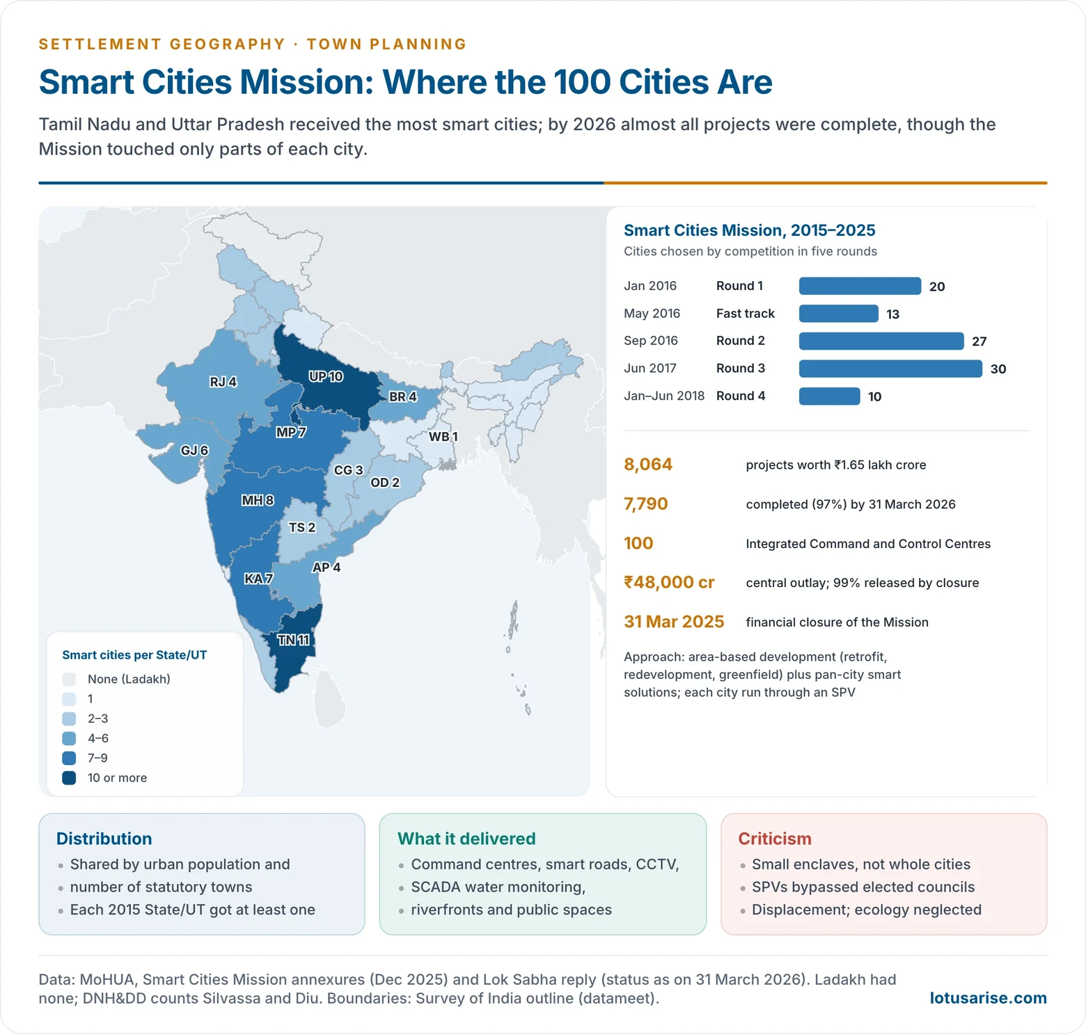
- Selection: a national City Challenge in five rounds from January 2016 to June 2018.
- The 100 places were shared among States by urban population and number of statutory towns.
- Tamil Nadu (11) and Uttar Pradesh (10) received the most.
- Strategy:
- Area-based development of part of each city, by retrofitting, redevelopment or greenfield development.
- Pan-city solutions using technology, such as command centres, smart meters and traffic management.
- Delivery: a Special Purpose Vehicle in each city, a company owned 50:50 by the State and the urban local body.
- Central assistance totalled ₹48,000 crore, matched by States and cities.
- Status: the Mission reached financial closure on 31 March 2025.
- By 31 March 2026, 7,790 of 8,064 projects (97%) worth about ₹1.56 lakh crore were complete.
- All 100 cities run Integrated Command and Control Centres.
- Outputs included over 83,000 CCTV cameras, more than 1,700 km of smart roads and over 17,000 km of SCADA-monitored water mains.
- In June 2025 the government told the SPVs to continue as implementing and technical agencies for the cities.
- Criticism:
- It touched small enclaves, not whole cities.
- SPVs bypassed elected councils, against the spirit of the 74th Amendment.
- It favoured technology over basic services, and some projects caused displacement and damage to wetlands and commons.
- CAG audits found delays and diversion of funds.
- The proposed new smart towns did little to reduce regional disparity, since the money went to existing cities.
Other Missions and Policies
- AMRUT (2015) and AMRUT 2.0 (2021): water supply, sewerage and green spaces.
- AMRUT 2.0 aims at water-secure cities in about 4,700 towns, and includes a sub-scheme for GIS-based master plans.
- PMAY-Urban (2015) and PMAY-U 2.0 (2024): affordable housing. The second phase targets 1 crore more houses.
- SBM-Urban (2014) and SBM-U 2.0 (2021): sanitation and garbage-free cities.
- National Transit-Oriented Development Policy (2017) and Metro Rail Policy (2017): they link land use to mass transit.
- HRIDAY (2015) for heritage cities.
- Urban Challenge Fund (Union Budget 2025–26) for “cities as growth hubs”, creative redevelopment, and water and sanitation.
- Together these missions are India’s main tools for the sustainable development of cities and for the problems of urbanisation such as congestion, water stress and pollution.
Problems and Prospects
- Problems:
- Planning lags far behind urbanisation. Unplanned peri-urban growth, unauthorised colonies and slums absorb much of the new population.
- Land acquisition is costly and contested.
- Municipal finances are weak.
- New towns attract the middle class but not enough jobs or poor households. Some, such as Nava Raipur and Lavasa, grew slowly or stalled.
- Planning is centralised in State agencies, with little public participation.
- Way forward:
- Universal plan coverage, including census towns and peri-urban areas, on GIS base maps.
- Regional and metropolitan planning through working Metropolitan Planning Committees.
- Land-based financing: land pooling, town planning schemes and value capture.
- TOD and mixed use, and affordable rental housing near jobs.
- Climate-resilient planning: protect floodplains and lakes, adopt heat action plans, and plan for disasters.
- More planners and stronger municipal cadres, and participation through ward committees and digital platforms.
- Small and medium towns as growth centres, so that planning spreads urban benefits instead of concentrating them.
Previous Year Questions
2006Discuss the elements and approaches of town planning in India.2012“Though 70% of Indian population is rural, urban planning is crucial to the development of India.” Discuss.2014Analyse the feasibility of ‘Smart Towns’ development in India.2015Reduction in regional disparities has been one of the priority goals of national planning in India. How the proposed new Smart urban centres may contribute to the process?2021Critically examine the importance of the Smart Cities Programme for solving the urban problems in India.2023Poor quality of urban planning in India is a huge constraint in realizing the true economic potentials of urbanization. Critically examine.2024How can morphology of Indian towns be described historically? Discuss the major features of the first planned city in India after independence.2025Why is systems analysis important in urban planning and what are its limitations?2026What are the principles of urban planning? Critically analyse town planning in India in the post-independence period.




