

- Precipitation is water in liquid or solid form falling from clouds and reaching the ground: rain, drizzle, snow, sleet, freezing rain, graupel and hail. Dew, frost and fog are condensation, not precipitation.
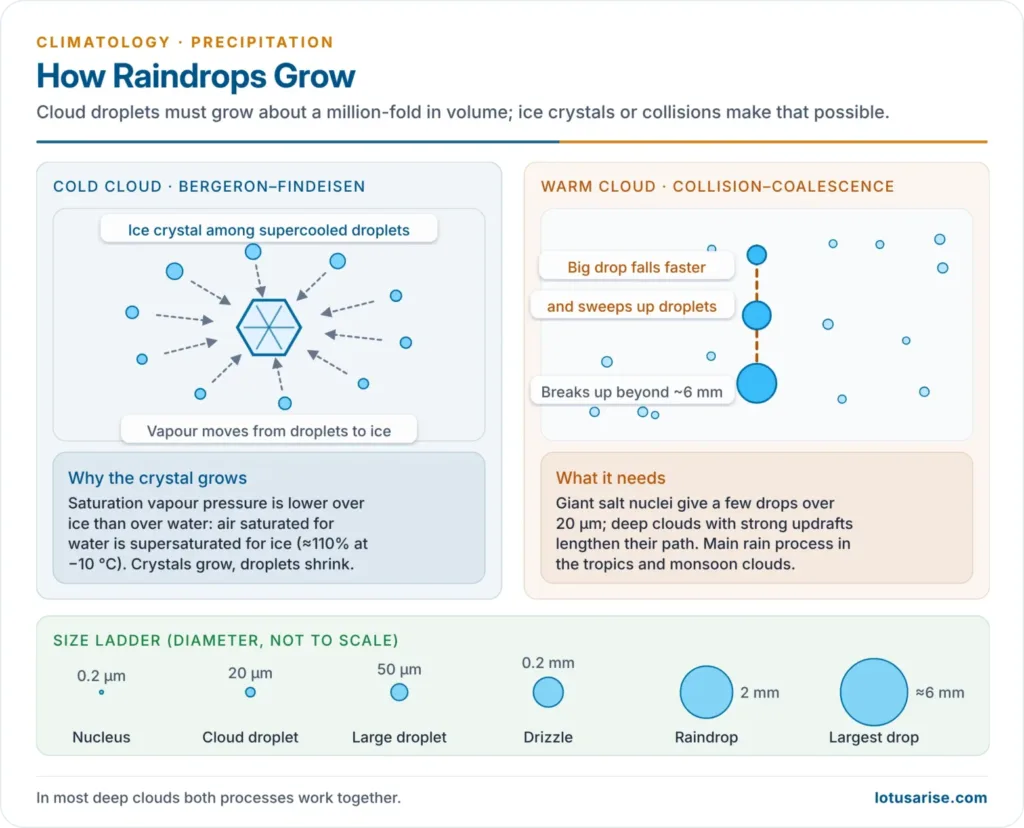
- Condensation alone does not make precipitation. Cloud droplets must grow about a million-fold in volume before they can fall, through the ice-crystal or the collision–coalescence process.
- Rainfall is precipitation in liquid form. It is classified by the way moist air is lifted and cooled: convectional, orographic and cyclonic (frontal).
The Precipitation Process
Why Most Clouds Do Not Rain
- A typical cloud droplet is only about 10–20 micrometres across; a raindrop is about 2 mm (0.5–6 mm), so one raindrop holds roughly a million cloud droplets.
- Tiny droplets fall at a few centimetres per second, are held up by the slightest updraft and evaporate within metres of leaving the cloud base.
- Growth by condensation alone is far too slow, because millions of droplets compete for the same vapour.
- A cloud of small, uniform droplets that do not merge is colloidally stable and gives no rain.
- Rain needs colloidal instability: a process that lets a few particles grow at the expense of the rest.
Bergeron–Findeisen (Ice-Crystal) Process
- Proponents: proposed by Alfred Wegener (1911), developed by the Norwegian meteorologist Tor Bergeron (1933) and confirmed experimentally by Walter Findeisen (1938).
- Assumptions (two properties of water):
- Cloud droplets do not freeze at 0 °C. They stay liquid as supercooled water down to about −40 °C unless they meet a rare ice (freezing) nucleus, most of which become active only at about −10 to −25 °C.
- Saturation vapour pressure over ice is lower than over water at the same temperature, so air saturated for water is supersaturated for ice.
| Temperature | RH with respect to water | RH with respect to ice |
|---|---|---|
| 0 °C | 100% | 100% |
| −10 °C | 100% | about 110% |
| −20 °C | 100% | about 121% |
- Mechanism:
- In a mixed cloud (ice crystals among supercooled droplets, best at −10 to −20 °C), vapour diffuses from the droplets to the crystals. The droplets evaporate and the crystals grow fast.
- Falling crystals sweep up supercooled droplets that freeze on them (riming) and stick together (aggregation) into snowflakes; broken splinters seed more crystals in a chain reaction.
- Snowflakes reach the ground as snow, or melt into rain below the freezing level.
- Glaciation turns the cauliflower top of a cumulonimbus into its flat anvil.
- Evaluation: it explains most precipitation in middle and high latitudes and from deep clouds anywhere, and it is the basis of silver-iodide cloud seeding. It cannot explain heavy rain from warm clouds whose tops never fall below 0 °C.
Collision–Coalescence (Warm-Cloud) Process
- Proponents: Irving Langmuir (1948) described a “chain reaction” of drop growth and break-up in warm clouds; the Australian physicist Edward George Bowen (1950) showed how coalescence produces rain.
- Mechanism:
- Giant hygroscopic nuclei (sea salt) form a few droplets larger than about 20 micrometres.
- Large drops fall faster, overtake small ones, collide and merge (coalesce), and grow faster still.
- Deep clouds with strong updrafts carry drops up and down repeatedly, lengthening their path. Drops beyond about 5–6 mm break up, and the fragments start the cycle again.
- Electric charge helps: oppositely charged droplets merge more easily (shown by Bernard Vonnegut and Charles B. Moore).
- Conditions: few but varied-size nuclei, high liquid-water content and great cloud depth. Clouds only about 2.4 km thick give showers over the tropical oceans.
- Evaluation: it explains tropical and maritime rain from clouds warmer than 0 °C, including much of the monsoon rain over India, and drizzle from stratus. In most real clouds both processes act together.
| Feature | Bergeron–Findeisen | Collision–coalescence |
|---|---|---|
| Cloud | Cold / mixed (below 0 °C) | Warm (above 0 °C) |
| Key element | Ice crystals among supercooled droplets | Large and small droplets of different sizes |
| Growth by | Vapour diffusion, riming, aggregation | Collision and merging |
| Typical region | Middle and high latitudes; deep clouds | Tropics, oceans, monsoon clouds |
| Seeding agent | Silver iodide, dry ice | Salt (hygroscopic seeding) |
Forms of Precipitation
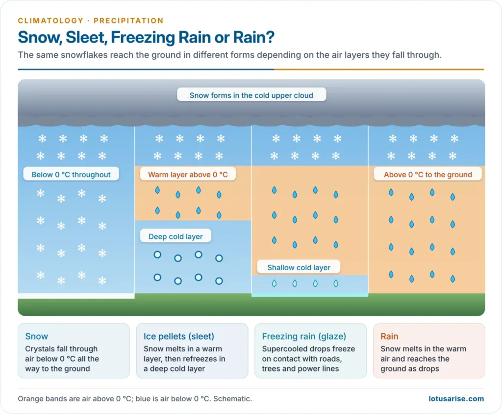
- The form depends on the temperature in which the particles form, the air layers they fall through, and the type and depth of cloud. All are called hydrometeors.
| Form | Description | Size | Typical cloud / setting |
|---|---|---|---|
| Rain | Liquid drops | Over 0.5 mm | Nimbostratus, cumulonimbus |
| Drizzle | Fine, close-set, uniform drops | Under 0.5 mm | Stratus |
| Snow | Branched hexagonal ice crystals and flakes | Variable | Below-freezing column |
| Sleet / ice pellets | Raindrops refrozen in a cold surface layer | Up to 5 mm | Warm layer over cold layer |
| Freezing rain (glaze) | Supercooled rain that freezes on contact | Drop size | Very shallow cold layer at the ground |
| Graupel | Soft, white, rimed snow pellets | 2–5 mm | Convective showers in cold air |
| Hail | Hard balls of concentric ice layers | 5 mm to over 15 cm | Cumulonimbus |
Rain
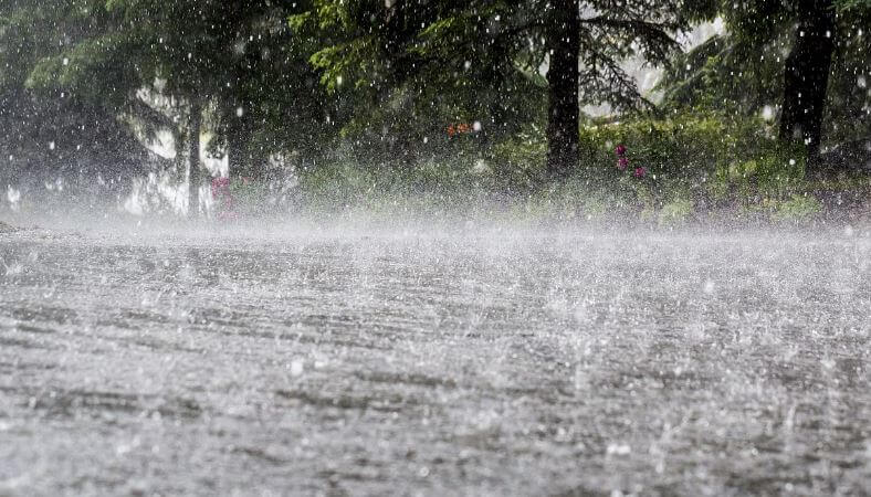
- Rain consists of drops larger than 0.5 mm. Small drops are spherical; large drops flatten underneath like a bun as they fall (not the “tear” of cartoons), and drops beyond about 6 mm break up.
- Heavy downpours come from deep clouds over moist lower air; light rain from high clouds may evaporate on the way down.
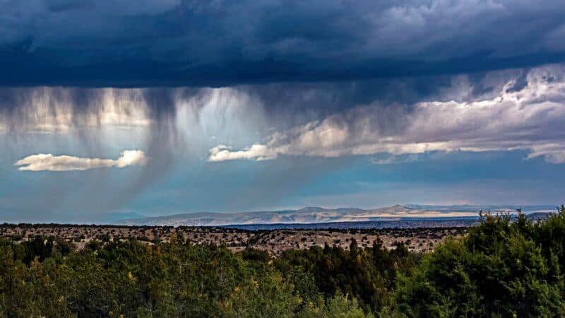
- Virga: streaks of rain or snow hanging below a cloud that evaporate or sublimate before reaching the ground, common over dry regions.
Drizzle
- Drizzle is fine, uniform drops (under 0.5 mm) so close together they seem to float. It falls from low stratus with high water content but little lifting, through nearly saturated air, and goes with fog and poor visibility.
- Below freezing it falls as freezing drizzle.


Snow
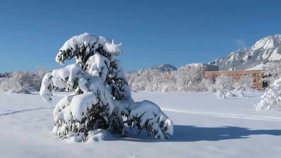
- Snow is precipitation of ice crystals, mostly six-sided plates, columns and branched stars, which join into flakes. Fresh snow is light, with roughly one-tenth the density of water.
- It forms when the whole air column is below freezing. The heaviest, wettest snowfalls occur when air is just below 0 °C, because colder air holds little moisture.
- In India, western disturbances bring winter snow to Jammu and Kashmir, Ladakh, Himachal Pradesh and Uttarakhand, feeding the snowmelt that sustains Himalayan rivers in summer.
Sleet and Freezing Rain
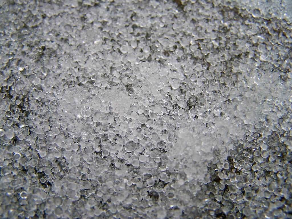
- Usage differs: in Britain and much of the Commonwealth, sleet means rain and snow falling together; in American usage it means ice pellets, frozen raindrops that bounce on hitting the ground.
- Ice pellets form when snow melts in a warm layer aloft and the drops refreeze in a deep cold layer near the ground.
- Freezing rain (glaze) forms when the cold surface layer is too shallow to refreeze the drops; supercooled rain then freezes on contact, coating roads, trees and power lines with ice.
Hail
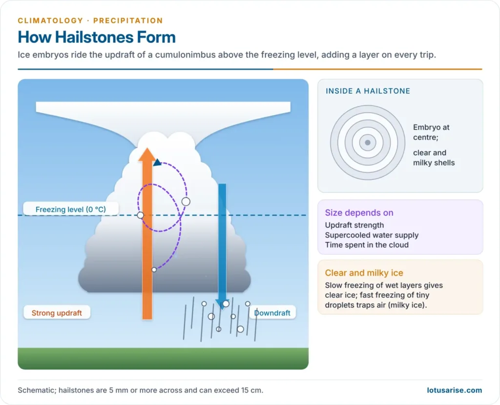
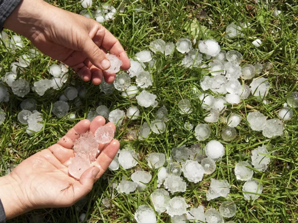
- Hail is the most destructive form: balls or lumps of ice 5 mm or more across, falling from cumulonimbus clouds in severe thunderstorms.
- Formation:
- Strong updrafts (which can approach 160 km/h) carry ice embryos or frozen drops repeatedly above the freezing level, where they collect supercooled water.
- Each journey adds a layer: clear ice where water freezes slowly, milky ice with trapped air where small droplets freeze fast. The cut stone shows onion-like rings.
- The stone falls when it is too heavy for the updraft. Its size depends on updraft strength, supercooled water content and time spent in the cloud.
- Records: the heaviest hailstone recorded, 1.02 kg, fell at Gopalganj, Bangladesh, on 14 April 1986; the largest by diameter, about 20 cm, fell at Vivian, South Dakota (USA), on 23 July 2010.
- Distribution: hail is most frequent in middle latitudes (30°–60°) over continental interiors, rare over oceans, in the humid tropical lowlands and in polar regions.
- In India, hailstorms strike mainly from March to May, damaging ripe rabi crops, orchards and vegetables in Maharashtra (Vidarbha, Marathwada), Madhya Pradesh, north-west India and the north-east.
Types of Rainfall
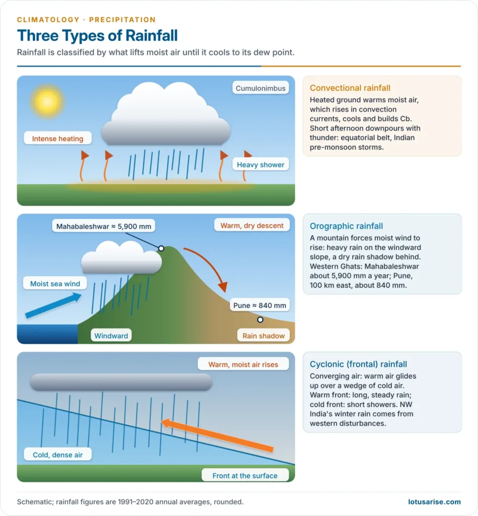
- Precipitation from extensive air masses needs adiabatic cooling, so rainfall is classified by what lifts the air. Once the air saturates, released latent heat often makes it unstable, and it keeps rising on its own.
Convectional Rainfall
- Mechanism: intense surface heating makes the moist air above it warm, expand and rise in convection currents. It cools adiabatically, builds cumulus and cumulonimbus, and falls as heavy showers.
- Conditions: strong heating plus abundant moisture (high relative humidity).
- Character:
- Heavy, short showers with thunder and lightning, sometimes hail, in the afternoon or evening; skies clear at night
- It gives the most rain with the least cloud cover
- Distribution:
- Daily in the equatorial doldrums (“4 o’clock rains” of the Amazon and Congo basins)
- Summer rain in continental interiors of middle latitudes
- William Morris Davis noted that equatorial rain is heavy partly because warm air loses capacity rapidly as it cools, releasing much water for each degree of cooling.
- Effectiveness: much of the downpour runs off, eroding loose soil, so it is less useful to crops in the tropics. In mid-latitude summers it falls during the growing season and is valuable.
- In India: pre-monsoon thunderstorms such as the nor’westers (kalbaisakhi) of Bengal, Odisha and Assam, the mango showers of Kerala and Karnataka, and afternoon thunderstorms within the monsoon.
Orographic (Relief) Rainfall
- Mechanism: moist winds blowing from the sea are forced to rise over a mountain barrier, cool, condense and rain on the windward slope. The mountain acts as a trigger; latent heat may then make the air rise further by convection.
- Rain shadow: the air crossing the crest has lost most of its moisture and warms by compression as it descends, so the leeward side is dry.
- Inversion of rainfall: rainfall increases up the windward slope only to a zone of maximum precipitation, then decreases towards the summit, because most moisture has already fallen.
- Examples:
- Western Ghats: Mahabaleshwar receives about 5,900 mm a year, while Pune, about 100 km east in the rain shadow, receives only about 840 mm.
- Mawsynram (about 11,900 mm a year) and Cherrapunji (Sohra) on the southern face of the Khasi Hills, where monsoon winds funnelled from the Bay of Bengal are forced up steep slopes, are the wettest places on Earth.
- The Himalaya catch the monsoon; Ladakh and the Tibetan Plateau lie in their rain shadow. Tamil Nadu is in the rain shadow of the Western Ghats during the south-west monsoon.
- Abroad: the wet western slopes of the Southern Alps (New Zealand), the Coast Ranges of North America and the southern Andes, with Patagonia in their rain shadow.
Cyclonic (Frontal) Rainfall
- Mechanism: large air masses converge and are lifted over a broad area.
- Tropical cyclonic rain: converging air of similar temperature rises almost vertically, with convection, in the ITCZ, easterly waves and tropical cyclones, giving heavy showers from cumulonimbus.
- Frontal rain (temperate): along fronts in temperate cyclones, warm moist air rises over a wedge of cold, dense air.
- Warm front: gentle ascent; nimbostratus gives widespread, steady, long-lasting rain or drizzle.
- Cold front: steep ascent; cumulonimbus gives short, heavy showers with thunder.
- Examples: most winter rain of Europe and North America; in India, the winter rain and snow of the north-west from western disturbances, and the heavy rain of Bay of Bengal cyclones over the east coast in October–December.
Monsoonal Rainfall
- Monsoonal rainfall comes from the seasonal reversal of winds that carry oceanic moisture onto land, as in South and South-East Asia. It is not a separate lifting mechanism: the rain of the Indian monsoon combines orographic uplift (Western Ghats, Himalaya), convergence in monsoon depressions and the monsoon trough, and convection.
| Feature | Convectional | Orographic | Cyclonic / frontal |
|---|---|---|---|
| Lifting by | Surface heating | Mountain barrier | Convergence; warm air over cold air |
| Clouds | Cumulus, cumulonimbus | Stratiform and cumuliform | Nimbostratus (warm front); Cb (cold front) |
| Duration | Short, heavy showers | Persistent while the wind blows | Hours to days |
| Area | Local | Windward slopes | Hundreds of km |
| Typical region | Equatorial belt; summer interiors | Western Ghats, Khasi Hills | Mid-latitudes; tropical cyclones |
World Distribution of Precipitation
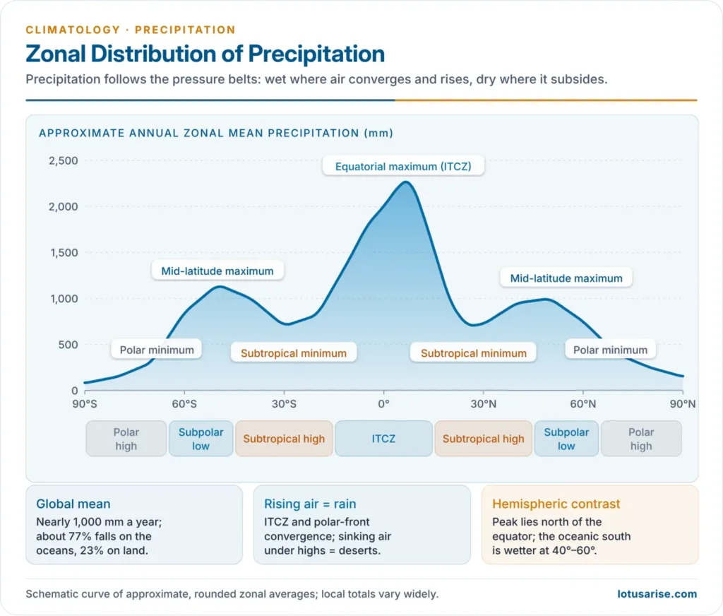
- The global mean precipitation is nearly 1,000 mm a year (roughly 487,000 km³ of water). About 77% falls on the oceans and 23% on land.
- It is very unevenly spread, from almost nothing in the Atacama to over 11,000 mm on the Khasi Hills.
Factors Controlling Distribution
- Latitude and pressure belts: rising air in convergence zones (ITCZ, polar front) gives rain; subsiding air under the subtropical highs and polar highs gives drought.
- Distribution of land and sea: maritime air is moist, continental air dry; interiors far from the sea (Central Asia, the Sahara, interior Australia) are dry.
- Prevailing winds: onshore winds bring rain, offshore winds little. Trade winds wet the eastern sides of continents in the tropics; westerlies wet the western sides in middle latitudes.
- Ocean currents: warm currents add moisture and instability; cold currents chill the air from below, stabilise it and give fog but no rain (Atacama, Namib).
- Mountain barriers: heavy rain on windward slopes, rain shadows behind (Western Ghats, Andes, Rockies).
- Monsoons: seasonal wind reversal concentrates rain in summer over South and East Asia.
Zonal Pattern
| Belt | Approximate latitude | Annual precipitation | Cause |
|---|---|---|---|
| Equatorial maximum | 10°S–10°N (peak just north of the equator) | Over 2,000 mm | ITCZ convergence, convection |
| Subtropical minimum | 20°–30° N and S | Under 250 mm in deserts | Subsiding air under subtropical highs |
| Mid-latitude secondary maximum | 40°–60° N and S | About 750–1,500 mm | Polar front, temperate cyclones, westerlies |
| Polar minimum | Beyond about 65°–70° | Under 250 mm | Cold air holding little vapour; polar highs |
- The wettest belt lies just north of the equator, because the ITCZ spends most of the year in the Northern Hemisphere.
- The southern mid-latitudes (40°–60°S) are wetter than the northern, because they are almost all ocean; the north has dry continental interiors.
- Subtropical anomaly: the western sides of continents near 20°–30° lie under the stable eastern flanks of subtropical highs, with cold currents and upwelling, so they hold the great west-coast deserts (Sahara, Namib, Atacama, Western Australia, Baja California). The eastern sides (south-east USA, south-east China, eastern Australia) receive moist onshore air and abundant rain.
Rainfall Regions by Amount
| Annual rainfall | Regions |
|---|---|
| Over 2,000 mm | Equatorial belt; windward coasts and slopes of monsoon lands; western slopes of mountains in the cool temperate zone |
| 1,000–2,000 mm | Tropical lands near the equatorial belt; humid eastern coasts of the subtropics |
| 500–1,000 mm | Interiors of tropical lands; eastern and interior parts of temperate lands |
| Under 500 mm | Hot deserts, rain-shadow interiors of continents, high latitudes |
Seasonal Regimes
| Regime | Rainy season | Cause | Example |
|---|---|---|---|
| Equatorial | All year; two maxima after the equinoxes | ITCZ and convection | Amazon, Congo, Singapore |
| Tropical (savanna) | Summer maximum, dry winter | ITCZ follows the sun | Sudan, Llanos |
| Monsoon | Summer, very dry winter | Seasonal wind reversal | India, South-East Asia |
| Mediterranean | Winter | Westerlies and cyclones in winter, subtropical high in summer | California, Mediterranean, central Chile |
| Continental | Summer (convection) | Interior heating; winter anticyclone | Interior North America, Eurasia |
| Maritime (west coast) | All year, autumn–winter maximum | Westerly cyclones | British Isles, British Columbia |
Variability and Intensity
- Variability is the departure of a year’s rainfall from the long-term mean, usually expressed as a percentage of the mean (coefficient of variation). The lower the mean rainfall, the higher the variability.
- Under about 15%: dependable (equatorial lands, mid-latitude cyclone belts)
- Over 30%: subtropical deserts and semi-arid margins, where a small shortfall ruins farming
- In India, variability is below about 25% on the west coast, the Western Ghats, the north-east and the eastern Ganga plain, but over 50% in western Rajasthan, Ladakh and parts of the interior Deccan. These high-variability, low-rainfall areas are the most drought-prone.
- Intensity (rain per rainy day or per hour) matters as much as totals: intense falls run off and erode, gentle falls soak in.
Extreme Rainfall and Cloudbursts
- Warming intensifies heavy rain: air holds about 7% more water vapour per 1 °C, and the IPCC Sixth Assessment Report (2021) finds that heavy precipitation intensifies at a similar rate, while global mean precipitation rises only about 1–3% per 1 °C.
- World extremes: the 24-hour record is about 1,825 mm at Foc-Foc, La Réunion (7–8 January 1966), under a tropical cyclone.
- Cloudburst: the India Meteorological Department defines it as 100 mm or more of rain in an hour over an area of about 20–30 km².
- Mechanism: moist monsoon air is pushed up steep Himalayan slopes; towering cumulonimbus hold water aloft in strong updrafts, then release it at once over a small catchment, causing flash floods, debris flows and landslides. Interaction of the monsoon with western disturbances sharpens the risk.
- Indian events: Leh (August 2010); Kedarnath (16–17 June 2013), where extreme rain combined with a moraine-lake breach; the Amarnath cave area (8 July 2022); Chasoti in Kishtwar (14 August 2025), which killed about 60 people.
- Not every Himalayan flash flood is a cloudburst: rainfall at Dharali (Uttarakhand) in August 2025 stayed below the threshold, and construction in the riverbed worsened the damage.
- Multi-day extremes cause even more damage: Himachal Pradesh (July 2023) and the Wayanad landslides (30 July 2024) followed very heavy rain over several days.
- Responses: Doppler-radar coverage of the Himalaya, nowcasting, slope and floodplain zoning, and early-warning systems. Rain can also be coaxed from suitable clouds by cloud seeding, though only on a small scale.
Previous Year Questions
2022Incidence of extreme rainfall events and flash floods in recent times have led to devastating consequences for people living in low-lying areas and flood plains of the country. Discuss.2021Examine major influencing factors for varied patterns of precipitations on the continents.2021Describe the problems of cloud burst in India giving suitable examples.2011Give an account of global distribution of precipitation.2000Give an account of the types and distribution of precipitation on the surface of the earth.





Awesome content
good information
Also add
Major influencing factors for varied pattern of precipitation.
Thank you so much for your information.
It is just like waw! What a content ❤️