

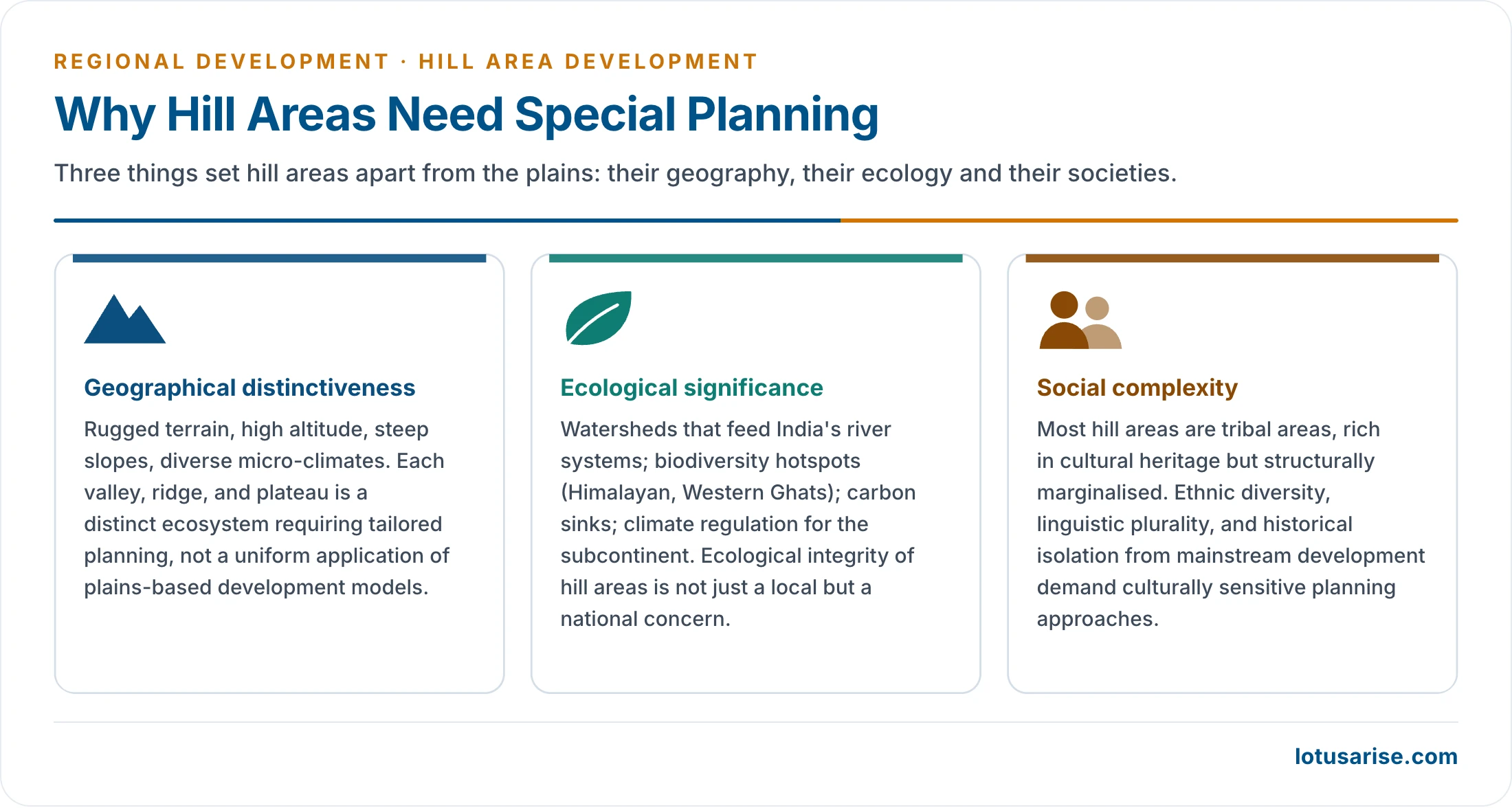
- Hill area development is the planning of mountainous and hilly regions on their own terms. Their slopes, climate, ecology and cultures make the methods of the plains fail.
- India’s hills run from the Himalaya and the north-eastern ranges to the Western Ghats, the Nilgiris and the Eastern Ghats. They hold the sources of the major rivers, most of the country’s glaciers and much of its forest and biodiversity. They are carbon sinks and regulate the climate of the subcontinent, so their ecological integrity is a national concern, not a local one.
- The Hill Areas Development Programme (HADP) and the Western Ghats Development Programme (WGDP), both begun in the Fifth Plan (1974–75), gave Special Central Assistance to designated hill areas inside larger States. Whole hill States were helped through special category status and, in the North-East, through the North Eastern Council and the Ministry of DoNER.
- The governing idea is that development should respect geography: growth in harmony with the ecology, through eco-restoration, eco-development and eco-preservation.
Hill Areas and the Case for Special Planning

Extent
- The Indian Himalayan Region (IHR) covers about 5.33 lakh sq km, 16.2% of India’s area. It spans 13 States and Union Territories over some 2,500 km and is home to nearly 50 million people, about 4% of the population.
- It holds about 36% of the country’s forest cover and all of its alpine and glacial systems.
- Hill areas in all were classically put at 18% of India’s area with about 70 million people; on 1951 Census data about 18.6% of the area was hilly (305–2,135 m).
- The hill areas under special programmes, the hill States together with the designated hill areas, were put at about 21% of India’s area and 9% of its population (22% and 10% in older counts). They are sparsely peopled, inaccessible and historically under-invested.
- Identifying a hill area. The areas under HADP were first identified in 1965 by a Committee of the National Development Council; the Western Ghats areas were recommended in 1972 by a high-level committee.
- The National Committee on the Development of Backward Areas (1981) suggested that hill areas above 600 m not covered by the Tribal Sub-Plan be treated as backward hill areas.
- Most hill areas are also tribal areas, served by the Tribal Sub-Plan and the Scheduled Area provisions of tribal area development. HADP added an area-specific layer on top, and all the general rural development schemes also ran in the hills.
Characteristics of Hill Areas
- Physiographic constraints: rugged terrain and steep slopes confine farming to terraces and grazing to meadows. Soils are thin, less productive and erosion-prone.
- Landslides, avalanches, earthquakes and cloudbursts are endemic. About 12.6% of India’s land (outside snow-covered areas) is prone to landslides.
- Climatic extremes: heavy rain on windward slopes, aridity in the rain-shadow, and winters that cut off high valleys for months. Warming is shrinking glaciers, raising cloudburst risk and shifting snowfall.
- Accessibility deficit: roads and railways cost several times more per km and are often seasonal. Isolation raises the cost of inputs, health care, schooling and markets.
- Ecological fragility: mountain ecosystems recover slowly from disturbance.
- The National Forest Policy (1988) sets the goal of two-thirds of the area of hills and mountains under forest, to protect slopes and watersheds. The older norm, from the 1952 policy, was 60%, and restoring 60% cover was a stated target of hill planning.
- High development cost: transport, land development, afforestation and energy all cost more per beneficiary than in the plains.
- Outmigration: working-age men leave for the plains, leaving ageing, feminised villages.
- Uttarakhand’s Rural Development and Migration Commission (2018) found 734 villages wholly depopulated after 2011, most in the hills; half of those who left went for want of jobs.
- Social complexity: ethnic and linguistic diversity, customary institutions and a history of isolation call for culturally sensitive planning.
- Development and outmigration feed each other: remittances pay for consumption, not investment, and men return only seasonally, so villages cannot keep up farm output.
| Dimension | Plains | Hill areas | Planning implication |
|---|---|---|---|
| Terrain | Flat, uniform | Steep, varied, slope-dominated | Infrastructure costs several times more; land-use planning essential |
| Soil | Deep alluvium | Thin, stony, erosion-prone | Terracing, cover, soil conservation |
| Climate | Predictable seasons | Altitudinal zones, extreme seasons | Zone-specific crops; climate adaptation |
| Connectivity | Dense road and rail | Sparse, seasonal roads | Connectivity before everything else |
| Economy | Commercial farming, industry | Subsistence farming, forests, tourism | Horticulture, plantation, eco-tourism, small industry |
| Population | Dense, urbanising | Sparse, rural, outmigrating | Community-based planning; women’s role central |
| Governance | Dense administration | Thin, distant administration | Decentralised planning; customary institutions |
Planning Philosophy
- Development of mountain regions rests on four costly foundations:
- transport network: roads, railways, ropeways and helipads. Connectivity is the master multiplier, since no other investment reaches people without it;
- land development: terraces, bunds, check dams and soil conservation that turn fragile slopes into stable fields and orchards;
- afforestation: restoring cover for slope stability, springs and forest livelihoods;
- energy: hydropower, small hydro and solar mini-grids, with benefits for hill communities, not only for distant consumers.
- Planning must build infrastructure while protecting the natural and cultural setting, so that the externalities of development do not destroy what makes the hills valuable.
- Hills are suited to high-value, low-volume activities: horticulture, plantations, herbs, handicrafts, tourism and pollution-free industries such as electronics, optical glass, watches and medicines, which value clean air and a cool climate.
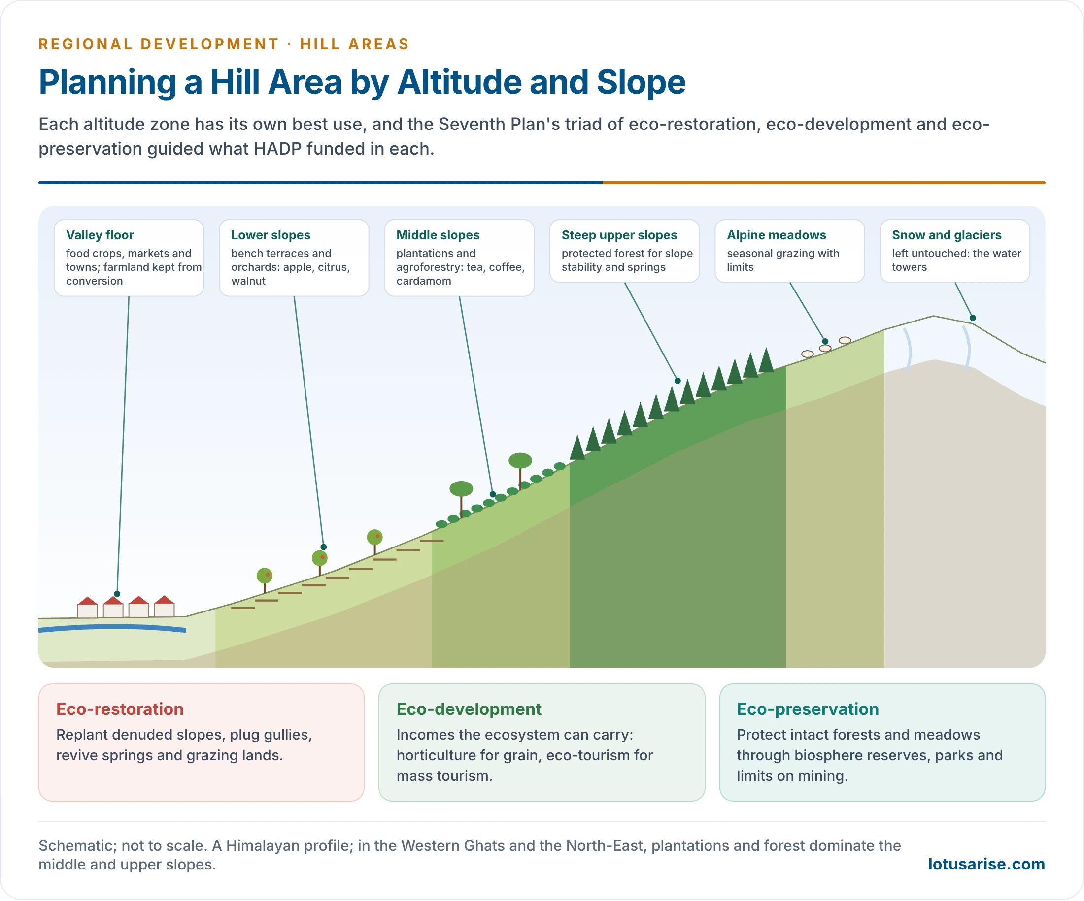
- Plan by altitude and slope. Land use should follow the zone:
- valley floors and river terraces: food crops, markets and settlements, with farmland protected from conversion;
- lower and middle slopes: terraced fields, orchards, plantations and agroforestry;
- steep upper slopes: protected forest for slope stability and spring recharge;
- alpine meadows: regulated seasonal grazing;
- snow and glacier zones: left untouched.
- Plans must compensate for losses. If a project takes forest, replanting should be mandatory. Small dams, tanks and lakes should hold water that would otherwise run off. Grain-deficit hills need food storage, so that farmers who give up shifting cultivation are not left short.
- Detailed field surveys, refreshed by remote sensing and GPS, and plans at regional, block and settlement level are needed, because each valley differs.
Hill Area and Western Ghats Development Programmes
Designated Hill Areas
- HADP began in 1974–75, in the Fifth Plan, alongside the Command Area Development Programme, the Tribal Sub-Plan and, from 1977–78, the Desert Development Programme. Hill areas were identified first among the area programmes. It supplemented State efforts in ecologically fragile hill areas with Special Central Assistance (SCA).
- Hill areas fall into two categories:
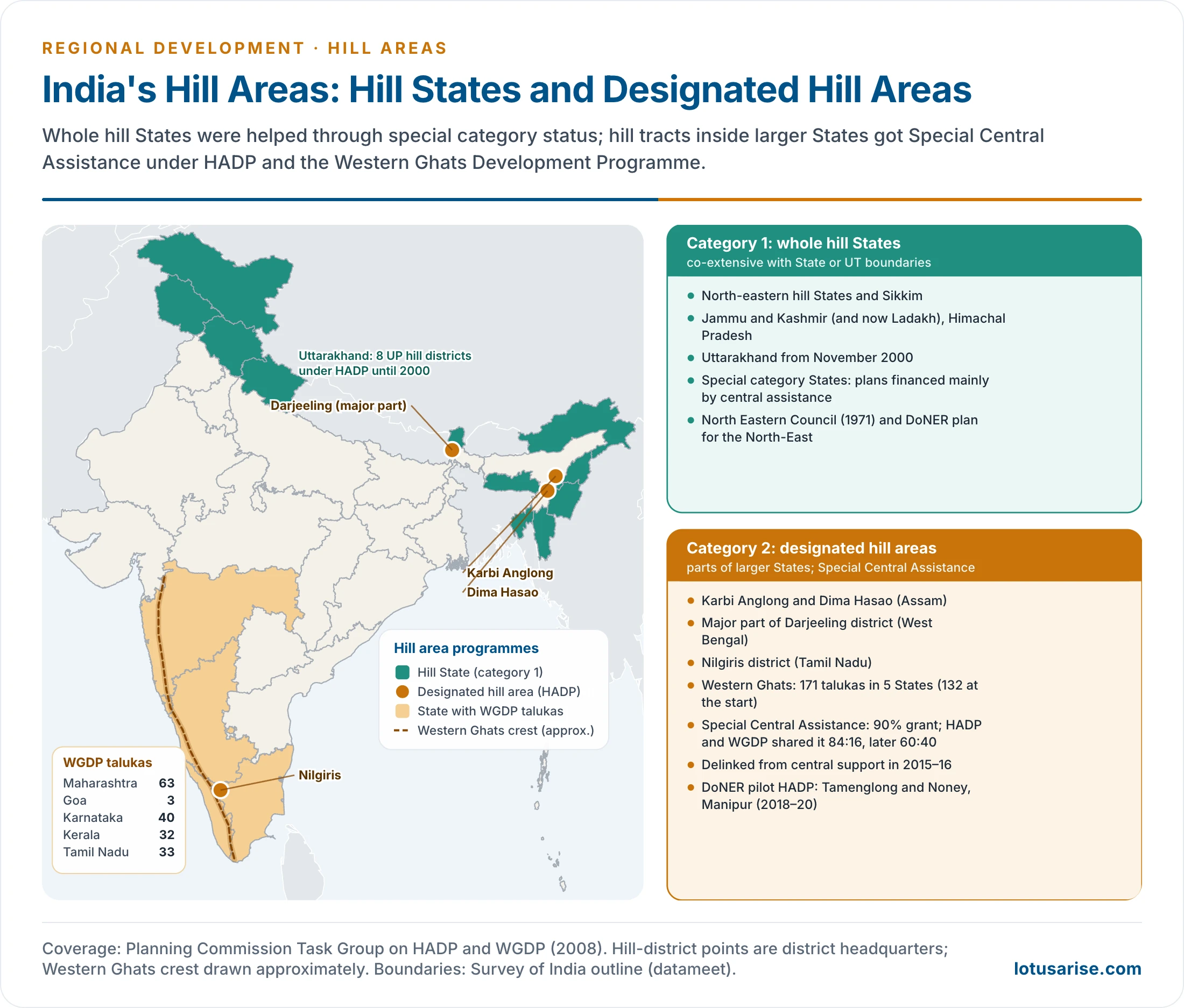
- Category 1: hill areas co-extensive with a State or Union Territory. These are the hill States of the North-East (Arunachal Pradesh, Manipur, Meghalaya, Mizoram, Nagaland, Tripura and Sikkim), Jammu and Kashmir, Himachal Pradesh and, from 2000, Uttarakhand.
- Assam, a special category State that is mostly plains, had its two hill districts under HADP instead.
- Most are special category States, whose plans are financed largely by central assistance.
- Category 2: designated hill areas, which form part of a larger State. The State is responsible for them, but central assistance is still needed.
- Peninsular hill systems belong here too: the Aravalli, Vindhyas, Satpura, Mahadev, Maikala, Ajanta, Western Ghats and Eastern Ghats. They run across States, and the State governments plan them.
- Category 1: hill areas co-extensive with a State or Union Territory. These are the hill States of the North-East (Arunachal Pradesh, Manipur, Meghalaya, Mizoram, Nagaland, Tripura and Sikkim), Jammu and Kashmir, Himachal Pradesh and, from 2000, Uttarakhand.
- Designated hill areas under HADP:
- the two hill districts of Assam: North Cachar Hills (now Dima Hasao) and Karbi Anglong (the old Mikir Hills), about 15,200 sq km, home to Dimasa and Karbi communities, with dense forest and tea;
- the major part of Darjeeling district in West Bengal, about 2,400 sq km: tea, tourism and the Gorkha cultural region;
- Nilgiris district in Tamil Nadu: the Nilgiri Biosphere Reserve, tea, coffee and tribal communities;
- the eight hill districts of Uttar Pradesh: Dehradun, Pauri Garhwal, Tehri Garhwal, Chamoli, Uttarkashi, Nainital, Almora and Pithoragarh, about 51,100 sq km: a Himalayan watershed with Char Dham, apples and tourism.
- When they became Uttarakhand (November 2000), a special category State, HADP ended there; their assistance became part of the new State’s normal central assistance.
- Older accounts call these the “original 15 districts” of HADP; the districts they list add up to 12.
Western Ghats Development Programme
- WGDP began in 1974–75 for the Western Ghats talukas of Maharashtra, Goa, Karnataka, Keralam (Kerala) and Tamil Nadu.
- Coverage:
- originally 132 talukas: Maharashtra 51, Keralam 27, Karnataka 28, Tamil Nadu 23, Goa 3 (about 1,37,000 sq km);
- 163 talukas in a middle count: Maharashtra 62, Karnataka 40, Tamil Nadu 29, Keralam 29, Goa 3;
- later 171 talukas as talukas were split: Maharashtra 63, Karnataka 40, Tamil Nadu 33, Keralam 32, Goa 3.
- Shifts in emphasis:
- Fifth Plan: horticulture, plantations, afforestation, minor irrigation, animal husbandry and tourism, aimed at exploiting hill resources;
- Sixth Plan: a balance between beneficiary schemes and ecological restoration; watershed development taken up on a pilot basis; universities and research institutions of the region drawn in;
- Seventh and Eighth Plans: integrated development of compact watersheds, with eco-development and eco-restoration overriding;
- Ninth and Tenth Plans: ecological balance, preservation of genetic diversity, restoration of damage and people’s awareness.
- In Tamil Nadu, for example, WGDP covered about 25.7 lakh ha in 33 taluks of eight districts, about a fifth of the State. From 1992–93 its works were confined to selected priority watersheds.
- The Western Ghats run about 1,600 km from the Tapi to Kanyakumari. They are a global biodiversity hotspot, and 39 of their sites became a UNESCO World Heritage Site in 2012.
- Their problems are plantation expansion, quarrying and mining (as in Goa), dams, roads on steep slopes and rising landslide risk.
- From 2011 the Ghats’ planning turned on conservation zoning:
- the Madhav Gadgil panel (2011) proposed treating the whole range as ecologically sensitive, graded in three zones;
- the K. Kasturirangan group (2013) limited the protected area to about 37% of the Ghats (some 60,000 sq km), mostly natural landscape.
Objectives
- Socio-economic development of the hills and their people in harmony with ecological development, promoting the basic life-support systems through sustainable use of natural resources.
- The ecological triad of the Seventh Plan:
- eco-restoration: rebuilding degraded slopes, gullies, wetlands, springs and grazing lands, and stabilising landslide-prone slopes;
- eco-development: raising incomes through activities the ecosystem can carry, such as horticulture instead of grain on steep slopes, eco-tourism instead of mass tourism, and sustainable harvest of forest produce instead of clear-felling;
- eco-preservation: protecting intact ecosystems through biosphere reserves, national parks, buffer zones and controls on construction and mining.
- People’s participation, especially of women, who manage most hill farms and forests where men migrate.
- Conservation of soil and water and land-use plans for both forest and cultivated land.
- Socio-economic development of tribal communities, as a complement to the Tribal Sub-Plan.
- Harnessing indigenous resources (horticulture, animal husbandry, forestry, plantations) through appropriate technology and market links.
- Infrastructure: roads, energy, communication, schools and health centres, the physical conditions for all else.
Components and Sectoral Focus
| Sector | Activities | Why it suits the hills | Example |
|---|---|---|---|
| Horticulture | Apple, pear, walnut, cherry, citrus, banana, grapes, kiwi; vegetables, flowers, herbs | Slopes unfit for grain give more income per hectare from fruit | Himachal and Uttarakhand (Pauri, Uttarkashi) apples; Darjeeling horticulture; Nilgiri vegetables |
| Plantations | Tea, coffee, cardamom and other spices, rubber at lower altitudes, coconut | High-rainfall slopes suit them; settles shifting cultivators | Darjeeling and Nilgiri tea; Western Ghats coffee and Munnar cardamom |
| Land use | Settling jhum cultivators on plantations and terraces | Reduces forest and soil loss | Coffee and rubber in the North-East |
| Animal husbandry | Dairy cattle, yak, sheep and wool, goats, pigs, poultry (low capital, quick income, often run by women), bee-keeping | Meadows support herds; regular cash for small farms | Uttarakhand dairy cooperatives, Himachal wool, NE piggery and backyard poultry, mithun, Nilgiri turkey and quail |
| Forestry | Social, farm and agroforestry; joint forest management; non-timber produce | Forest is the main ecological and livelihood asset | Van Panchayats in Uttarakhand |
| Industry | Pollution-free, high-skill units; handloom, carpets, sericulture, bamboo and cane, crafts, agro-processing, tourism enterprises | Clean air, cool climate, local skills | Electronics in the Shivaliks; Manipur handloom; Darjeeling crafts; Nagaland bamboo; Uttarakhand agro-processing |
| Conservation | Biosphere reserves, national parks, gene sanctuaries | Integrated protection of flora and fauna | Nilgiri Biosphere Reserve |
| Watershed | Ridge-to-valley land and water treatment, with boundaries from ISRO remote sensing | The natural planning unit in the hills | Nilgiri Bhavani–Moyar–Kabini plan; Uttarakhand micro-watersheds |
| Afforestation | Planting by Panchayats, schools and local bodies; private nurseries of multipurpose trees | Slope stability and water; community planting outlasts departmental planting | Van Panchayats; north-eastern community forests; Western Ghats agroforestry |
- Discouraging jhum. On many north-eastern slopes the jhum cycle has shortened, damaging forests and soils. HADP encouraged settled cultivation and plantations, with food stocks to tide over farmers who gave up jhum.
- Linkages between fruit-growing and fruit-consuming areas, cooperatives and farmers’ service societies, and food storage in grain-deficit hills.
Evolution Across the Plans
| Plan | Approach | Emphasis |
|---|---|---|
| Fifth (1974–79) | Beneficiary-oriented | Individual assets and income |
| Sixth (1980–85) | Shift towards eco-development | But still the sectoral pattern of a State Plan |
| Seventh (1985–90) | Eco-restoration, eco-preservation, eco-development | Integrated socio-economic and ecological plans |
| Eighth (1992–97) | People’s involvement and basic needs | Energy to relieve forests, fuel–fodder plantations, gravity drinking water, skills, land-use planning, clean industry, feeder roads; a special push on infrastructure as the binding constraint |
| Ninth (1997–2002) | Eco-preservation and eco-restoration | Biodiversity; traditional knowledge as the starting point; hill sub-plans; larger allocation and community involvement |
| Tenth (2002–07) | Watershed development | A “watershed plus” approach: ecology and livelihoods together; common guidelines (December 2002) |
- The Eighth Plan’s list of measures remains a good summary of hill planning:
- an energy policy that lowers pressure on forests;
- fuel and fodder species in afforestation;
- gravity-fed drinking water from springs and streams;
- better primary health care and skilled manpower;
- a land-use pattern fitted to ecological and social limits;
- horticulture, plantations and better livestock;
- non-polluting, high-value industry;
- feeder paths and roads;
- appropriate technology built on local resources.
Financing
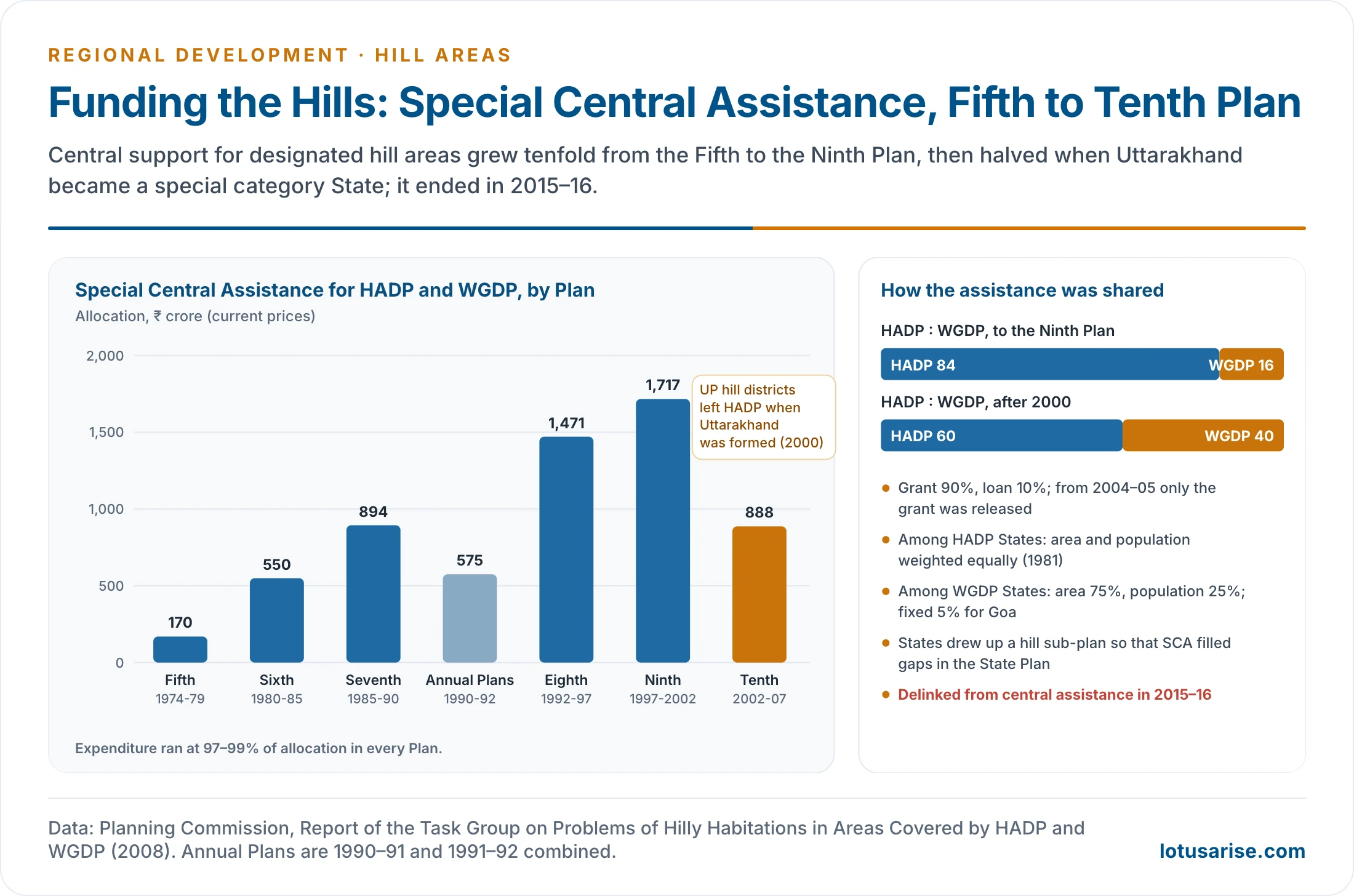
- HADP and WGDP were funded through Special Central Assistance, over and above the normal central assistance that the Gadgil formula shared among States.
- SCA was 90% grant and 10% loan. From 2004–05 only the grant was released, and States raised the loan part from the market.
- Division of SCA:
- between HADP and WGDP: 84:16 up to the Ninth Plan; 60:40 after Uttarakhand left HADP;
- among HADP States: equal weight to area and population (1981);
- among WGDP States: 75% area and 25% population, with a fixed 5% for Goa.
- The States prepared a hill sub-plan showing the flow of funds from the State Plan and SCA, so that SCA filled critical gaps rather than duplicating State schemes.
- Allocations by plan (₹ crore): Fifth 170; Sixth 550; Seventh 894; Annual Plans (1990–92) 575; Eighth 1,471; Ninth 1,717.
- They fell to 888 in the Tenth Plan, after the Uttar Pradesh hill districts left HADP.
- Older accounts give a wider series for hill allocations: ₹540 crore (Fifth), rising to ₹5,400 crore (Ninth), a tenfold rise. It is not the same measure as the SCA series above, whose rise is of the same order.
- North-East: from the Seventh Plan a dedicated allocation runs in the name of the North Eastern Council, so that other backward regions do not crowd it out.
- Special category status was granted by the National Development Council from 1969 to States with:
- hilly and difficult terrain;
- low population density or a large tribal population;
- a strategic location along international borders;
- economic and infrastructural backwardness;
- non-viable State finances.
- Eleven States held it: the eight north-eastern States, Himachal Pradesh, Uttarakhand and Jammu and Kashmir (a Union Territory since 2019).
- Special category States received central assistance on 90:10 grant–loan terms under the Gadgil formula.
- Today they share most centrally sponsored schemes at 90:10.
- The 14th Finance Commission (2015) stopped treating them separately in tax devolution.
Problems in Implementation
- Isolation and mistrust: past displacement and exploitation made many hill and forest communities wary of government projects. Development has to be rights-based and community-led.
- Insurgency and conflict: militancy in parts of Jammu and Kashmir and the North-East deterred investment and slowed the Kashmir railway.
- The French consortium building the Dulhasti hydro project left in the early 1990s amid militancy; the project was finished only in 2007.
- Inter-ethnic conflict, as in Manipur since 2023, halts work, as do rivalries among groups such as the Nagas and Bodos.
- Weak utilisation of funds: poor project preparation, few contractors, short working seasons and cost overruns left funds unspent in several States. Central assistance reached about ₹5,200 per head in the North-East, yet Nagaland and Arunachal Pradesh used only about 60% of their HADP funds, with corruption and leakage adding to the loss. Weak institutions, more than want of need, explain the gap, though SCA as a whole was spent at 97–99% of allocation.
- Tension between tribes and non-tribes as migrants from the plains compete for land, jobs and trade in hill towns. Development that brings in outsiders without benefiting locals deepens the conflict.
- Disasters overwhelm budgets: Kedarnath (2013), Chamoli (2021), the Joshimath subsidence (2023), the South Lhonak lake outburst in Sikkim (2023) and Wayanad in the Western Ghats (2024). Each cost far more than regular hill budgets.
- Urban bias: district headquarters and hill stations gain most; remote villages stay cut off.
- This repeats the core–periphery pattern within the hills, and pushes migration from villages to hill towns and on to the plains.
- Low awareness and scattered settlement: small, dispersed hamlets make services costly and participation thin.
- Climate change: retreating glaciers, drying springs, shifting apple belts and more frequent flash floods.
- Thin spreading: a mini-State Plan approach spread SCA over too many sectors to change any one.
Present Status
- In the Union Budget 2015–16, after the 14th Finance Commission raised States’ share of central taxes to 42%, HADP and WGDP were delinked from central assistance, to be continued from States’ own resources.
- Tamil Nadu replaced them with a Special Area Development Programme (2015–16) for hill areas above 600 m.
- Maharashtra closed WGDP in 2017.
- DoNER ran a pilot Hill Area Development Programme in Tamenglong and Noney districts of Manipur (2018–19 and 2019–20). It sanctioned 41 projects worth ₹90 crore to narrow the gap between hill and valley districts, and has no plan to extend it.
- Hill areas are now served by general schemes run at 90:10 in hill States: PMGSY roads, Jal Jeevan Mission, the watershed component of PMKSY (with springshed treatment) and DAY-NRLM. Targeted missions sit on top of these.
The North-East and the Himalaya
North-Eastern Region
- North Eastern Council (NEC): set up by an Act of Parliament in 1971 as a statutory regional planning body, also engaged in research and human development. Sikkim was added in 2002.
- It funds inter-State projects in power, roads, agriculture, tourism, health and higher education.
- Ministry of Development of North Eastern Region: a Department from 2001 and a Ministry from 2004, the only ministry with a territorial jurisdiction.
- Current DoNER schemes:
- the Non-Lapsable Central Pool of Resources (unspent central funds pooled for the region);
- the North East Special Infrastructure Development Scheme (NESIDS, 2017–18) for roads and social infrastructure;
- the Schemes of NEC;
- PM-DevINE (October 2022): ₹6,600 crore for 2022–23 to 2025–26, fully central. By February 2026 it had sanctioned 48 projects worth about ₹6,044 crore.
- These schemes ran to the end of the 15th Finance Commission period (March 2026); continuation for the next cycle was under appraisal in March 2026.
- Industrial incentives:
- the Transport Subsidy Scheme (July 1971) covered the North-East, Himachal Pradesh, Uttarakhand, Jammu and Kashmir, Darjeeling, and the Andaman and Nicobar and Lakshadweep islands.
- It subsidised the cost of carrying raw materials in and finished goods out of these remote areas, offsetting the distance penalty that keeps industry away.
- It was replaced by the Freight Subsidy Scheme (January 2013), discontinued in November 2016. About ₹5,289 crore was released in all, nearly 90% of it to the North-East.
- Its record was mixed. It drew some units to Assam, Meghalaya and the Himalayan States, but benefits were concentrated in a few large units and districts. There were complaints of misuse, and few local linkages formed.
- Later incentives came through the North East Industrial Development Scheme (2017) and UNNATI (2024).
- Such incentives are one of the planning instruments against regional imbalance.
- the Transport Subsidy Scheme (July 1971) covered the North-East, Himachal Pradesh, Uttarakhand, Jammu and Kashmir, Darjeeling, and the Andaman and Nicobar and Lakshadweep islands.
- Development issues of the North-East:
- per capita incomes below the national average in most States, and a large gap between hill and valley districts;
- insurgency and ethnic conflict, though much reduced since the 2000s;
- community ownership of land, which protects tribal rights but makes bank credit and land markets harder;
- Sixth Schedule autonomous councils that plan for their own areas alongside State governments;
- dependence on a single land route through the Siliguri corridor.
Connectivity
- Rail:
- the Udhampur–Srinagar–Baramulla line was completed in June 2025, with the Chenab bridge, 359 m above the river, the world’s highest rail arch bridge;
- the Bairabi–Sairang line (September 2025) made Aizawl the fourth north-eastern capital on the rail network, after Guwahati, Agartala and Itanagar;
- the Jiribam–Imphal line is slated for December 2028.
- older extensions: Kumarghat to Agartala, now open, and a proposed Kathgodam to Nainital link;
- about 25 major rail projects in the North-East, 11 of them National Projects, including Lumding–Sabroom, Rangiya–Murkongselek and the Agartala–Akhaura link to Bangladesh.
- Roads:
- the Char Dham all-weather road in Uttarakhand, linking Yamunotri, Gangotri, Kedarnath and Badrinath;
- SARDP-NE, the road programme of the North-East: 5,468 km sanctioned with the Arunachal Package at ₹63,542 crore, 3,699 km done by mid-2024. Older accounts give 44,000 km, which overstates it;
- about 9,000 km of high-altitude all-weather roads by the Border Roads Organisation (older figure), and the roughly 1,800 km Trans-Arunachal Highway linking district headquarters;
- a road map under the Vision 2020 North East document;
- the Sela tunnel (2024) in Arunachal Pradesh;
- NESIDS and PMGSY roads for remote villages.
- Vibrant Villages Programme:
- VVP-I (February 2023): ₹4,800 crore for 2,967 villages in 46 blocks along the northern border, in Arunachal Pradesh, Sikkim, Uttarakhand, Himachal Pradesh and Ladakh;
- VVP-II (April 2025): ₹6,839 crore for other land borders.
- Both aim to reverse outmigration from border villages.
- Energy:
- the North-East and the Himalaya hold most of India’s hydropower potential, much of it in Arunachal Pradesh and still untapped. Older accounts put the North-East at over 40,000 MW with only 2% harnessed;
- large dams raise questions of seismic risk, downstream flows and displacement, so small hydro and solar mini-grids suit remote villages better;
- local power cuts the use of diesel and fuelwood, both costly to carry uphill.
- Digital links: BharatNet to gram panchayats; satellite broadband (OneWeb, Starlink) for the remotest valleys; telemedicine and online learning for villages beyond the road.
- Regional links: the Act East Policy (2014) treats the North-East as a gateway to South-East Asia.
- The Kaladan multimodal project via Sittwe in Myanmar and road links to Bangladesh aim to break the region’s dependence on the narrow Siliguri corridor.
- Ecological risk: slope-cutting for wide roads in fragile terrain has triggered landslides, and the Char Dham widening drew sustained criticism. Tunnels, ropeways and careful alignment reduce the damage.
Himalayan Disasters and Their Lessons
- Kedarnath (June 2013): extreme rain and the collapse of a moraine-dammed lake flooded the Mandakini valley; thousands died, many of them pilgrims.
- Chamoli (February 2021): a rock and ice avalanche in the Rishiganga valley swept away hydro projects at Raini and Tapovan.
- Joshimath (January 2023): land subsidence cracked hundreds of houses in a town built on old landslide debris and loaded by construction.
- Sikkim (October 2023): the outburst of South Lhonak lake destroyed the Teesta III dam at Chungthang.
- Wayanad (July 2024): landslides after extreme rain buried villages in the Western Ghats.
- Lessons:
- hazard zonation before construction;
- limits on building in river beds and on unstable slopes;
- glacier-lake and slope monitoring with early warning;
- cumulative assessment of hydro projects along a river;
- disaster funds sized to mountain risk.
Himalayan Missions and Institutions
- G. B. Pant National Institute of Himalayan Environment (Almora, 1988): research and policy for the IHR.
- National Mission for Sustaining the Himalayan Ecosystem (NMSHE): one of the eight missions of the National Action Plan on Climate Change (2008), coordinated by the Department of Science and Technology. It is the only mission defined by a region; its plan was approved in 2014.
- National Mission on Himalayan Studies (2015–16), under the Ministry of Environment, Forest and Climate Change.
- Carrying capacity: after the Joshimath subsidence, the Supreme Court (2023) took up the carrying capacity of Himalayan towns, and expert assessments of hill towns followed.
- NITI Aayog’s working groups (2017–18) on the IHR, including one on the inventory and revival of springs.
- About 3 million of India’s 5 million springs lie in the IHR, and many are drying.
- A Planning Commission Task Force on hill States, chaired by G. B. Mukherji, urged:
- zoned planning, protecting snow, alpine, forest and water zones and barring construction on slopes over 30°;
- strategic environmental assessment of river basins in place of project-by-project clearance;
- ridge alignments and slope protection for roads;
- a green bonus that rewards hill States for their forests and the ecosystem services they send to the plains.
Soil and Water Conservation in Hill Areas
Why It Is the Central Challenge
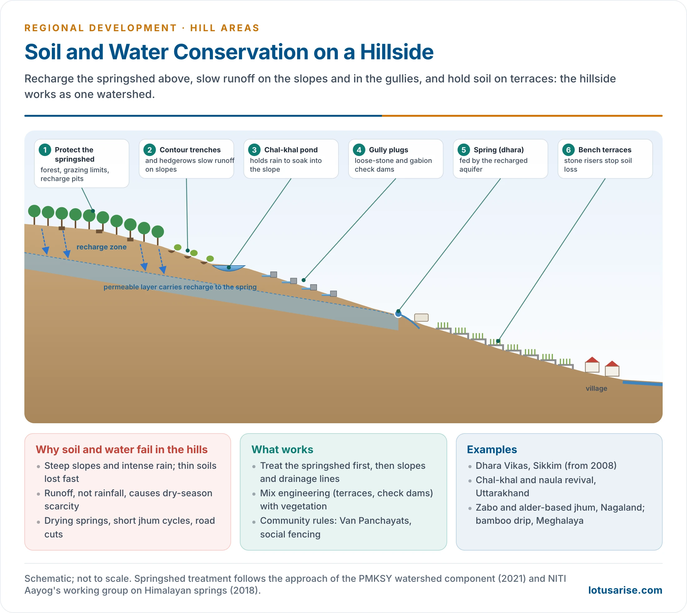
- Steep slopes and intense rain strip thin soils fast; once lost, soil on a slope takes centuries to form.
- Runoff, not rainfall, is the problem: even high-rainfall hills such as Cherrapunji’s plateau face dry-season water scarcity, because water runs off instead of soaking in.
- Drying springs: springs feed most hill households. Their discharge is falling with land-use change, roads, deforestation and erratic rain; in Sikkim about half the springs have lost flow.
- Shortened jhum cycles leave slopes bare before forest can recover.
- Landslides and siltation: degraded slopes slip, and their silt fills reservoirs and riverbeds downstream.
- Degraded commons: overgrazing and fuelwood cutting on village forests and pastures.
- Construction: roads, hydro projects and towns built without drainage plans destabilise slopes, as at Joshimath.
- The problem differs by hill region:
- Shivaliks: soft rock, deforestation and torrents (choes) that spread sand over the fields of the foothills;
- Middle Himalaya: landslides on road cuts, falling discharge of springs (naula and dhara), abandoned terraces where people have migrated;
- North-East: heavy rain on steep slopes, short jhum cycles, and in Meghalaya acid drainage from coal mining, banned by the National Green Tribunal in 2014;
- Western Ghats and Nilgiris: erosion from plantations and vegetables on steep slopes, laterite quarrying, and landslides in very heavy rain, as at Wayanad.
Conservation Measures
- Bench terracing with stone risers and grassed edges; contour trenches and staggered trenches on non-arable slopes.
- Drainage-line treatment: gully plugs, gabion and loose-stone check dams, and chal-khal recharge ponds in Uttarakhand.
- Springshed management: map the recharge zone by hydrogeology, then protect it with trenches, pits and vegetation.
- Dhara Vikas in Sikkim (from 2008) revived springs and lakes this way.
- Springshed treatment is now an activity of the PMKSY watershed component and is to be central to its next phase.
- Biological measures: contour hedgerows, agroforestry and fodder grasses. Alder-based jhum in Nagaland keeps nitrogen-fixing trees in the fallow.
- Improved jhum and settled farming:
- Nagaland’s NEPED project (from the mid-1990s) improved jhum with trees;
- Mizoram’s New Land Use Policy (2010) moved jhum farmers to settled livelihoods.
- Traditional systems:
- zabo in Nagaland, which combines forest catchment, ponds and paddy;
- bamboo drip irrigation in Meghalaya;
- Apatani rice–fish terraces in Arunachal Pradesh;
- kuhls in Himachal Pradesh;
- naula and dhara springs in Kumaon.
- Community management: Van Panchayats in Uttarakhand (since 1931), joint forest management, and social fencing: a voluntary, self-imposed discipline by which villages manage grazing, cutting and water.
- Watershed planning, ridge to valley, makes these measures work together: watershed management treats the whole hillside, from springshed to stream, as one unit.
Livelihoods and Skills
- The hill economy needs skills more than land. Holdings are small and slopes steep, so growth must come from value, not volume.
- Sectors with an edge in the hills:
- horticulture and food processing: apple, kiwi, citrus, large cardamom, ginger, turmeric;
- plantations and organic farming;
- tourism and hospitality: homestays, trekking, adventure and pilgrimage services;
- handloom, sericulture (muga and eri silk in Assam), bamboo and cane crafts;
- herbal and medicinal plants;
- clean, high-skill industry and IT-enabled services in hill towns.
- Institutions and schemes:
- Krishi Vigyan Kendras and Van Vigyan Kendras;
- Pradhan Mantri Kaushal Vikas Yojana and DDU-GKY placement-linked training;
- SHGs under DAY-NRLM;
- State homestay and tourism schemes.
- What makes skilling meaningful:
- training matched to local resources and markets, not generic courses;
- certification, credit and market links (cold chains, GI tags, online sales);
- courses delivered in or near the villages, with a focus on women, who run most hill farms;
- local jobs that let young people stay, the surest check on outmigration.
The Way Forward
- Political and administrative commitment, with ring-fenced funds for hill areas.
- People’s participation, especially of women, through Gram Sabhas, customary councils and SHGs.
- A comprehensive, area-specific scheme for hill areas, in place of uniform national norms.
- Skills for the hills: training in horticulture and food processing, tourism and hospitality, handloom and crafts, and herbal products. Krishi and Van Vigyan Kendras serve women farmers and forest users.
- Skilled local jobs are the surest check on outmigration.
- Value from hill products:
- GI tags such as Darjeeling tea;
- agro-processing clusters;
- organic certification, which Sikkim made State-wide in 2016.
- Eco-tourism within carrying capacity, with limits on construction in fragile towns.
- Climate adaptation: disaster risk reduction as a core part of hill plans, glacier-lake monitoring, spring revival and climate-resilient crops.
- Rights and institutions: PESA and the Forest Rights Act in Scheduled Areas, and the autonomy of Sixth Schedule councils.
- Payment for ecosystem services: compensating hill States for the water, forests and climate regulation they provide to the plains.
- Safer infrastructure: geology-led alignments, tunnels and ropeways, and building codes enforced in seismic zones.
| Area | Key measures |
|---|---|
| Governance | Ring-fenced funds, hill sub-plans, decentralised planning, hill panchayats, PESA and Forest Rights Act, construction codes in seismic zones |
| Women and skills | Krishi and Van Vigyan Kendras, SHG networks, women in land-use decisions, gender-sensitive roads and health access |
| Community management | Social fencing, Van Panchayats, joint forest management, watershed user associations, Gram Sabha control of resources |
| Livelihoods | GI products (Darjeeling tea, Kinnaur apple, Nilgiri honey), One District One Product, agro-processing, eco-tourism, renewable energy |
| Climate and disasters | Risk-based planning, spring revival, glacier-lake monitoring, safe construction, eco-sensitive zones around vulnerable ridges, crops beyond apple |
| Connectivity | Roads, rail, ropeways and digital links built with geology in mind; helipads for medical emergencies |
Previous Year Questions
2026Soil and water conservation are the major challenges in the development of hill areas of India. Explain.2017Explain the role of ‘Hill Transport Subsidy Scheme’ in reducing regional imbalances in areas identified by the Government of India.2014How can a meaningful skill development programme contribute to the economic growth of hill areas?





Nice content !! Really helps in geography optional .
Thanku so much ma’am/sir
I was unable to understand the concept now it is crystal clear.