

Regional Planning as a Tool for Correcting Regional Imbalance

- Regional planning refers to formulating different plans for different regions, depending on various factors including resource endowments, stage of socio-economic development, geographical location, and the aspirations of local people. It is a deliberate, policy-driven exercise that treats each region as a distinct planning unit with its own combination of problems, potentials, and priorities.
- Regional planning is distinct from national sectoral planning in a fundamental way: while sectoral planning asks “how much food, industry, or infrastructure should be produced nationally?”, regional planning asks “where should it be produced, and for whom?” It has an explicit spatial dimension — it is planning with a map, not just with an economic model.
- In the context of India’s vast and persistent regional imbalances — the income gap between Goa and Bihar, the industrial concentration in Maharashtra-Gujarat while Bihar and Jharkhand remain backward, the connectivity deficit in the North-East — regional planning becomes the primary instrument for spatially redistributive justice. It is not merely a technical exercise but a tool of social policy with geographic expression.
Regional Planning and Spatial Differentiation:
- The concept of regional planning very well supports the idea of spatial differentiation but complementary units — as discussed by Richard Hartshorne in his concept of areal differentiation.
- Hartshorne considered the earth as a mosaic of landscapes, wherein every landscape is part of a unique combination of its constituent elements, which differentiates it from the adjoining landscape. The notion of regional planning talks about making utilisation of this differentiated landscape according to its potential, while also taking care of the complementary relationship that exists between adjoining landscapes.
Factors Determining Regional Planning
Regional planning is not a uniform, one-size-fits-all exercise. Different regions require different planning frameworks based on the following four determining factors:
1. Resource Endowments and Potential of Resource Exploitation
- Each region has a distinct resource base — mineral wealth (Chota Nagpur), water resources (Indo-Gangetic Plain), forest cover (North-East), marine resources (coastal states), solar energy potential (Rajasthan), hydro-power potential (Himalayan states).
- Regional planning must assess these endowments, identify the potential of their exploitation, and align planning investments with that potential.
- For example, Rajasthan’s regional planning has increasingly centred on solar energy rather than water-intensive agriculture — a shift driven by resource endowment analysis.
2. Stage and Level of Socio-Economic Development
- A region that is entirely agrarian and subsistence-based requires fundamentally different planning instruments than one that is transitioning to industrialization, or one that is already industrially mature but facing urban congestion. India’s planning for the BIMARU states (Bihar, MP, Rajasthan, UP) — largely agrarian with high poverty — differs from planning for the congested Mumbai Metropolitan Region or the rapidly urbanizing Bengaluru.
- The stage of development determines whether infrastructure creation, industrial promotion, or urban management should be the primary planning thrust.
3. Nature of Geographical Location / Geographical Setting
- A region’s physical geography — whether it is a coastal zone, hill region, desert, floodplain, tribal forest area, or island territory — fundamentally shapes what kind of development is ecologically feasible, economically viable, and socially appropriate.
- Regional planning for Lakshadweep (tiny coral atolls, climate-vulnerable) differs from planning for the Thar Desert (arid, desert-prone, sparse population) or the Himalayas (fragile, inaccessible, disaster-prone).
- The geographical setting is the spatial container within which all other planning decisions must operate.
4. Aspirations of the Local People
- Development planning divorced from local aspirations generates resistance and ultimately fails. India’s experience — from anti-dam movements (Narmada Bachao Andolan), to tribal rights movements (Forest Rights Act), to demands for regional statehood (Telangana, Jharkhand) — demonstrates that regional planning must incorporate the aspirations of local communities.
- The 73rd Constitutional Amendment (Panchayati Raj) and the Forest Rights Act (2006) represent institutional recognition of this principle: planning must hear and respond to local voices, not just national planners.
Objectives of Regional Planning as a Tool for Imbalance Correction
Regional planning, as a tool for addressing regional imbalances, tends to achieve the following three interconnected objectives:
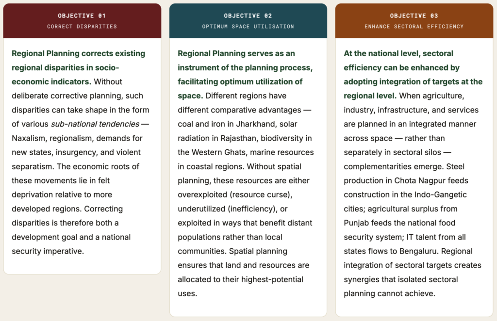
Regional Imbalance → Subnational Tendencies: The Critical Link
The most politically consequential objective of regional planning is the prevention of the subnational tendencies that emerge from uncorrected regional imbalances. These are not abstract risks — India’s history is replete with examples of how economic deprivation in a region transforms into political or violent mobilisation:
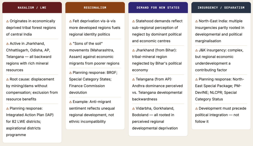
The Political Economy of Regional Imbalance: Regional disparities are not just economic — they are political. When a region consistently receives less than its share of national resources, when its resources are extracted for the benefit of distant populations without local benefit, and when its people migrate to developed regions only to face discrimination, the result is a potent mix of grievance and identity that can destabilize national cohesion. Regional planning is therefore not just development policy — it is the spatial dimension of national integration.
Different Approaches of Regional Planning
Regional Planning can be studied under two broad frameworks that cut across all specific approaches:
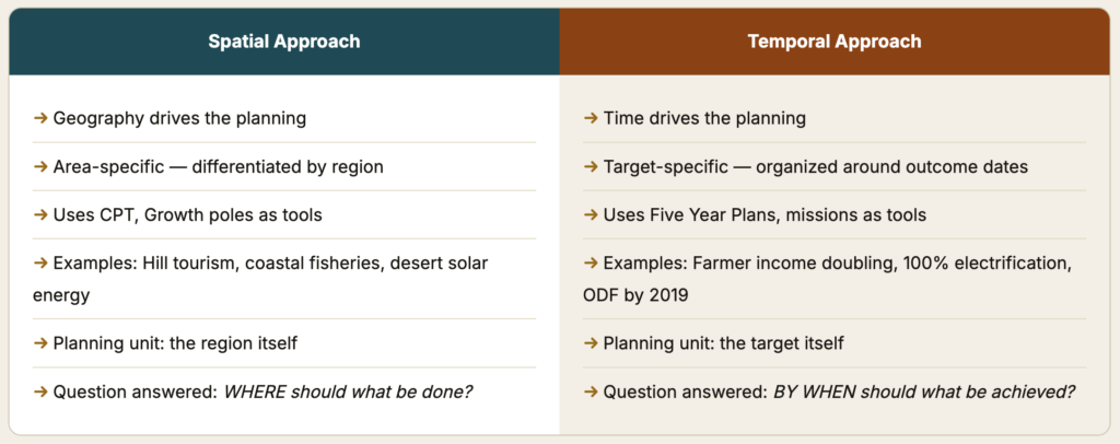
1. Primary Framework: Spatial vs. Temporal
- Based on what drives the planning — is it the geographic characteristics of a specific area (spatial) or a time-bound target for a region (temporal)? These are complementary, not alternatives.
2. Secondary Framework: Regional vs. Area Development
- Based on the scope of the planning unit — is it a broader region defined by functional hierarchies (regional planning approach) or a specific problem area/group (area development approach)?
| Approach | What It Means | Key Tool/Theory | India Example |
|---|---|---|---|
| Spatial Approach | Area-specific planning for particular goals, accounting for local socio-economic and geographic factors | Growth poles, Growth centres, CPT | Planning for hill poverty reduction through tourism (Himachal Pradesh) |
| Temporal Approach | Time-bound targets for a specific region as the primary planning driver | Five Year Plans, Mission-mode programmes | Doubling farmers’ income by 2022; 100% electrification by Saubhagya |
| Regional Planning Approach | Planning limited to a particular region, identifying hierarchical relationships and allocating activities at each level | Christaller’s CPT; growth poles at hierarchy levels | Chota Nagpur industrial development; DMIC corridor planning |
| Area Development Approach (Problem-specific) | Targeting specific geographic problems — drought, desert, hill areas, floods | DPAP, DDP, HADP, Command Area Development | Drought Prone Area Programme (70+ districts); Desert Development Programme (20 districts) |
| Area Development Approach (Group-specific) | Targeting specific social groups within an area — tribal populations, small farmers | Tribal Sub-Plan, SFDA, MFAL | Tribal Area Development Programme; Small Farmers Development Agency |
Spatial Approach and Temporal Approach
A. Spatial Approach
- In a spatial approach, the area-specific planning is put into action for the achievement of particular goals, keeping in account the local socio-economic and geographical factors of the region. The planning process is tailored to the characteristics of the specific region — not a uniform national template applied everywhere.
- Example: Planning to reduce poverty in hilly areas by the promotion of tourism — leveraging the scenic, cultural, and biodiversity assets specific to mountain regions, rather than trying to impose plains-style agricultural or industrial development on terrain that is unsuitable for it.
- Local socio-economic factors: What is the existing livelihoods base? What is the skill profile? What are the cultural practices? Planning must build on these, not replace them
- Geographical factors: What is the terrain, climate, soil, water availability, connectivity? These set the physical parameters of what is feasible
- Central Place Theory (CPT), Growth Poles, and Growth Centres are examples of the implementation of the spatial approach — they provide the theoretical framework for spatial allocation of development activities
- Contemporary Indian applications: Aspirational Districts Programme (ADP) — 112 specific districts receiving tailored convergence of 42+ central schemes; NE special packages targeting the specific connectivity and developmental deficits of North-East India
B. Temporal Approach
- In the temporal approach, time is the major factor which is taken into consideration in the planning process of a particular region. Planning is organized around time-bound targets for specific regional outcomes.
- Example: Planning for doubling the farmer’s income by 2022 in a particular region — a time-bound target that organizes all regional planning instruments (credit, irrigation, markets, technology) toward achieving that specific outcome within the specified timeframe.
- Five Year Plans are the primary instrument of temporal planning in India — 1st to 12th FYP each set time-bound targets for regional sectors
- Mission-mode programmes with specific completion timelines: PMGSY (rural roads), Jal Jeevan Mission (piped water to all households), Saubhagya (household electrification), Swachh Bharat (open defecation free)
- Aspirational Districts delta-ranking: Monthly monitoring of changes in 49 indicators — creates temporal urgency and accountability within spatial planning
- Climate targets as temporal planning: India’s NDC targets (45% emission intensity reduction by 2030; 50% non-fossil power by 2030) combine spatial (which regions transition first) and temporal (by when) dimensions
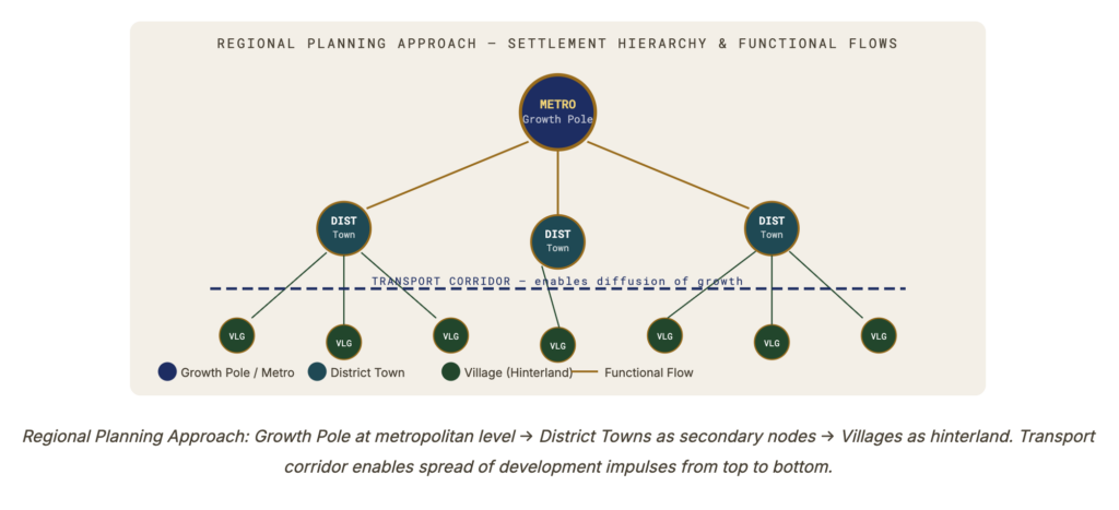
Regional Planning Approach — Using Hierarchy and Complementarity
- In the Regional Planning Approach, the planning process is limited to a particular area, keeping the various planning entities of the region into account.
- Example: planning for the development of the Chota Nagpur region through industrial development — treating the entire mineral-rich plateau as an integrated planning unit, allocating steel, power, and mining industries at appropriate hierarchical levels.
- This approach is applied with the help of the principle of hierarchy of settlements, given by Christaller, and the Growth Poles and Growth Centres concepts of Perroux and Boudeville.
The Functional Hierarchy Principle
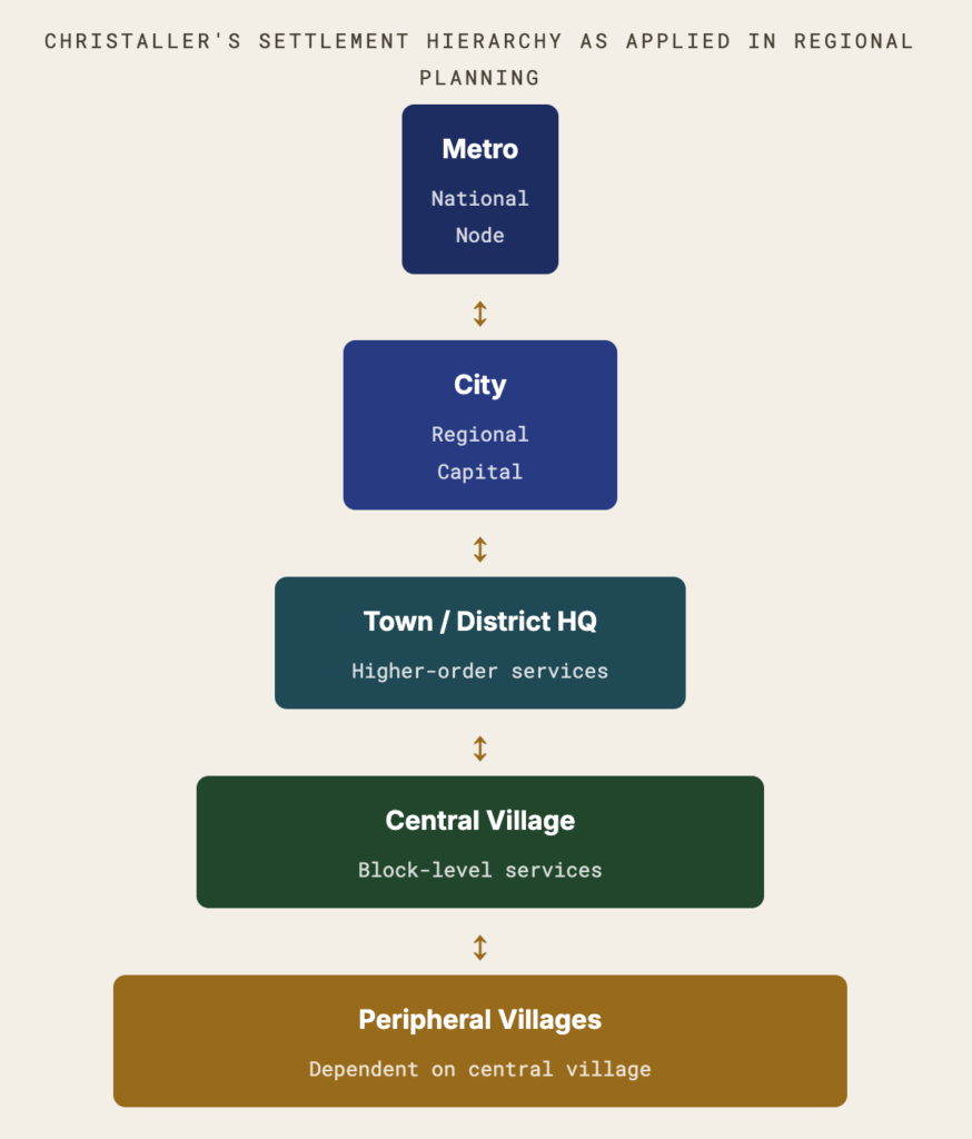
- The core insight of the Regional Planning Approach is that a functional relationship exists among settlements. In rural areas, for example:
- One village acts as the central village and provides services (market, school, health sub-centre, panchayat office) to surrounding villages
- That central village depends upon a higher-order settlement — typically a town — for higher-order services (hospital, college, wholesale market, tehsil office)
- The town depends on a city for even higher-order services (university, specialized hospital, regional headquarters)
- This creates a nested hierarchy of settlements organized by functional interdependence
The Planner’s Role in the Regional Planning Approach
- Regional planners, following the Regional Planning Approach, perform two key functions:
- Identify hierarchical relationships: Map the functional dependency structure of settlements in the region — which villages depend on which market towns? Which towns draw on which city? Where are the gaps in the hierarchy (missing market towns, absence of district-level services)?
- Decide activity allocation at each level: Determine which activity should be located at which level of the hierarchy — so that complementary functions can exist among them, ensuring integrated development of the entire region. For example: primary schools at village level, secondary schools at block level, colleges at district level, universities at regional level.
Transport and Communication as Enablers: Following these principles, planners deliberately tend to locate Growth Poles and Growth Centres at a certain level of the hierarchy and simultaneously facilitate the development of transport and communication lines so that the growth pole can generate the required impact on the hinterland. Without transport connectivity, a growth pole at the district headquarters level cannot diffuse its economic impulses to villages 50 km away. The connectivity is what transforms a point of development into a regional growth process.
Christaller’s Central Place Theory and Regional Planning
- Christaller’s Central Place Theory (1933) identified a hierarchical system of market centres, each serving a specific hinterland.
- The theory organizes settlements by their range (maximum distance consumers travel for a service) and threshold (minimum population needed for a service to be economically viable).
- Planning applies this theory by deliberately placing services at the appropriate hierarchical level to ensure all settlements are served within accessible range.
Complementary Regions and Christaller
- Christaller proposed a hierarchy of complementary regions — the hinterland of each central place that it exclusively serves. Each complementary region is nested within the complementary region of the next higher-order centre.
- The principle of complementarity means that settlements of different orders are not competitors but functionally interdependent — they complement each other by providing different levels of service.
| Settlement Order | Services Provided | Complementary Region | India Example (Planning) |
|---|---|---|---|
| Village (lowest) | Daily needs — water, basic food, informal credit | Hamlet cluster | Gram Panchayat as planning unit; Jal Jeevan Mission water point |
| Central Village / Small Market | Weekly market, health sub-centre, primary school, agricultural inputs | Revenue circle / cluster of villages | Block-level Growth Focus (R.P. Misra) — health, school, market, bank branch |
| Block HQ / Small Town | Secondary school, primary health centre, commercial bank, tehsil court, wholesale mandi | Block territory | Block Development Office; PMGSY road connectivity to block HQ |
| District Town | Hospital, degree college, district court, DRDA, commercial market, engineering college | District | District Planning Committee; BRGF district grants; district SDG targets |
| Regional City / Divisional HQ | Specialized hospital, university, wholesale distribution, regional court, industrial agglomeration | Multi-district zone | Regional development authority; Growth Centre for industrial zone; SEZ nodes |
| Metropolis | National-level finance, IT, research, international airport, specialized medical care | State / multi-state | Mumbai Financial Centre, Bengaluru IT hub, Delhi government; DMIC mega-nodes |
Area Development Approach
- The Area Development Approach is the second major approach in regional planning. Unlike the Regional Planning Approach (which focuses on the functional hierarchy of settlements across a broad region), the Area Development Approach focuses on specific areas with particular problems or specific social groups with particular disadvantages.
- It has two sub-types:
Sub-type A: Planning Based on Area-Specific Problems
- This includes planning with respect to various area-specific problems such as floods, droughts, desertification, hill terrain fragility, etc. The area is selected because it faces a particular geographic problem that requires targeted intervention — a problem that cannot be solved through general national sectoral planning.
| Programme | Problem Targeted | Target Area | Key Interventions |
|---|---|---|---|
| DPAP — Drought Prone Area Programme (1973) | Chronic drought | 70+ chronically drought-prone districts across Rajasthan, AP, Karnataka, Maharashtra, MP, Gujarat, Odisha, UP | Watershed treatment, soil conservation, water harvesting (johad, kund), afforestation, alternative livelihoods |
| DDP — Desert Development Programme (1977) | Desertification and arid conditions | Hot arid (Rajasthan 16 districts, Gujarat 2, Haryana 2, J&K 1); Cold arid (Ladakh, Lahaul-Spiti) | Sand dune stabilization, shelter belts (Prosopis, Acacia), solar energy, water harvesting (kund, bawdi), oasis development |
| HADP — Hill Area Development Programme (5th FYP) | Hill terrain fragility, inaccessibility, outmigration | 15 hill districts in UP (now Uttarakhand), WB, Assam, Manipur, Tamil Nadu, Himachal Pradesh | Horticulture (apple, temperate fruits), animal husbandry, forest-based industries, road connectivity, erosion control |
| CAD — Command Area Development (1974-75) | Gap between irrigation potential created and utilized | Major and medium irrigation command areas across India | Field channels, drains, warabandi, on-farm water management — closing the “last mile” of irrigation |
| IWMP — Integrated Watershed Management (2009) | Degraded land and rainfed agriculture inefficiency | Merged DPAP + DDP + IWDP; ₹12,000/ha norm; community-based | Ridge-to-valley watershed treatment; community ownership; livelihood integration |
Sub-type B: Planning Based on Specific Groups of an Area
- This includes various programmes targeting specific social groups within an area — recognizing that geographic area-based planning may not reach marginalized groups who are socially or economically excluded even within the targeted region.
- Tribal Area Development Programme
- Tribal Sub-Plan (1974-75): Ring-fenced funds proportional to Scheduled Tribe population share. Administered through ITDPs/ITDAs. PESA Act (1996) for Schedule V areas. Modified Area Development Approach (MADA) for tribal pockets with 50%+ ST concentration. Forest Rights Act (2006) as rights complement.
- Small Farmers Development Agency (SFDA)
- SFDA (1971): Targeted at small and marginal farmers (holdings < 2 ha) who were excluded from Green Revolution benefits. Credit, technology, marketing support specifically for this class. Later evolved into IRDP → SGSY → NRLM, extending the group-specific approach to rural poor more broadly.
- MFAL — Marginal Farmers and Agricultural Labourers
- Companion to SFDA — targeted agricultural labourers and marginal farmers with even smaller holdings. Credit and training for allied activities (animal husbandry, fishery, sericulture) to diversify livelihoods beyond crop cultivation.
- DWCRA — Women Group Planning
- Development of Women and Children in Rural Areas: Group-specific planning targeting rural women through self-help groups (SHG model). Predecessor to the SHG-bank linkage programme that now covers 7 crore+ women through NRLM/Aajeevika.
Growth Poles in Practice — India’s Steel Towns
- The 2nd Five Year Plan (1956-61) implemented the Regional Planning Approach at its most ambitious scale — locating three integrated steel plants in backward regions as growth poles intended to generate multiplier effects in their hinterlands. This is India’s most important case study of regional planning as a tool for imbalance correction — and of its limitations.
| Steel Plant | Location | Resource Basis (Weber Model) | Intended Growth Pole Effect | Actual Outcome |
|---|---|---|---|---|
| Bhilai Steel Plant | Durg, Chhattisgarh (then MP) | Dalli-Rajhara iron ore, Korba coal — weight-losing materials proximate to plant | Industrialize Chota Nagpur-Chhattisgarh plateau; provide employment to tribal populations; generate regional multiplier | Bhilai township developed well; but surrounding Bastar district remained India’s most backward. Tribal displacement without cultural integration. Naxalism rooted partly in post-Bhilai exclusion. |
| Durgapur Steel Plant | Durgapur, West Bengal | Raniganj-Jharia coal + Noamundi iron ore (Jharkhand) | Industrialize the Damodar Valley region beyond DVC power; create industrial hub for West Bengal | Durgapur industrialized into a medium industrial city. West Bengal stagnation overall continued — Durgapur did not become a large-scale regional growth engine. |
| Rourkela Steel Plant | Sundargarh, Odisha | Bonai-Koira iron ore, Jharsuguda coal — both within Odisha | Develop backward Odisha; employment for tribal Sundargarh district; anchor for regional industrial development | Rourkela city developed. But KBK districts (Kalahandi-Bolangir-Koraput) — Odisha’s poorest — remained completely untouched by Rourkela’s growth. |
Critical Analysis — Why Steel Towns Failed as Growth Poles
The Unskilled Jobs Problem and Cultural Mutation
The basic assumption was that these steel plants would serve as Growth Poles and generate a multiplier effect in the adjoining hinterland. However, this did not happen on a large scale — for two interconnected reasons:
- Most local population landed unskilled jobs: The skilled technical and managerial positions went to people from developed regions (engineers from IITs, managers from metropolitan areas), while the local tribal population received only unskilled construction and menial work. The multiplier effect generated by higher-wage skilled employment did not accrue to the local population.
- Cultural mutation of displaced communities: Those who got displaced were thrown into the flux of cultural mutation — struggling to assimilate with an alien industrial culture fundamentally different from their forest-based tribal traditions. The loss of community, forest, and livelihood led to social breakdown: human trafficking, drug abuse, alcoholism, and other social evils became pervasive in communities displaced by the steel plants — a planning failure of enormous human consequence.
- Bhopal et al. (2015): India has displaced an estimated 50+ million people through development projects since 1947 — tribals constituting one-third of total displaced despite being 8.6% of population. The pattern of steel towns is replicated across mining, dams, and industrial projects throughout India’s planning history.
Weber’s Least Cost Location Model
The three steel plants were located “in tune with the resource endowment of the region and the principle of least cost with respect to the availability of raw materials (Weber Model).” Alfred Weber’s (1909) industrial location theory identifies the point of minimum transport cost for raw materials and finished products as the optimal industrial location. Since iron and steel production requires massive quantities of iron ore, coal, and limestone (all weight-losing — material weight exceeds product weight), the least-cost location is near the raw materials, not the market. This is why Bhilai (near Dalli-Rajhara ore and Korba coal), Durgapur (near Raniganj coal), and Rourkela (within Odisha’s mineral belt) were geographically rational choices. The planning failure was social and economic, not geographic.
Hartshorne’s Areal Differentiation — The Geographic Foundation of Regional Planning
- The concept of regional planning very well supports the idea of spatial differentiation but complementary units as discussed by Richard Hartshorne in his concept of areal differentiation. Hartshorne considered the earth as a mosaic of landscapes, wherein every landscape is a part of the unique combination of its constituent elements, which differentiates it from the adjoining landscape.
- The notion of regional planning talks about: (1) making utilization of this differentiated landscape according to its potential; and (2) taking care of the complementary relationship which exists between adjoining landscapes.
The Mosaic of Landscapes — Applied to India
- Hartshorne’s metaphor of the earth as a “mosaic of landscapes” resonates powerfully with India’s extraordinary geographic diversity:
- Himalayan Landscape
- Unique combination: high altitude, glaciers, fragile ecology, tourist appeal, hydro-power potential, medicinal plants. Differentiated from the plains below. Planning must exploit the tourism and hydro-power potential while protecting the fragile ecology.
- Indo-Gangetic Plain
- Deep alluvial soil, flat terrain, river water, dense population — globally unmatched agricultural potential. Planning exploits this for food production (Green Revolution) — complement the Himalayas’ water storage function.
- Chota Nagpur Plateau
- Ancient crystalline rocks = iron ore, coal, manganese, bauxite. Dense forest — tribal culture. A landscape differentiated by its mineral wealth. Planning uses this for industrial growth poles — with the complementary responsibility not to destroy the forest culture.
- Thar Desert
- Highest solar radiation in India, sparse population, arid conditions. A landscape whose potential is not agriculture (as it was long exploited for) but solar energy. The world’s largest solar parks (Bhadla, Rajasthan) represent planning aligned with this landscape’s true potential.
- Coastal Zones
- Marine access, port potential, fisheries, coastal biodiversity. Complementary to the inland agricultural hinterland — exporting its surplus, receiving manufactured goods. Planning for SEZs, ports, and fisheries development must respect the CRZ ecological boundary.
- North-East India
- Extraordinary biodiversity, oil and natural gas, tea and rubber, cultural diversity, hydro-power rivers. A frontier landscape — complement to the national economy as resource provider. Planning must ensure this complementary relationship benefits the region, not just the centre.
- Himalayan Landscape
Areal Differentiation + Complementarity = Regional Planning Logic
“Hartshorne considered the earth as a mosaic of landscape wherein every landscape is a part of the unique combination of its constituent elements, which differentiates it from the adjoining landscape. The notion of regional planning talks about making utilization of this differentiation landscape according to their potential. At the same time, it also talks about taking care of the complementary relationship which exists between adjoining landscapes.”
The Planning Synthesis: Hartshorne’s areal differentiation tells us why regions differ — each landscape has a unique combination of physical, cultural, and economic elements. Regional planning translates this geographical insight into policy: (1) plan for each landscape’s specific potential (not a uniform template); and (2) ensure that the complementary relationships between landscapes are managed to the benefit of all — so that Jharkhand’s coal benefits Jharkhand’s people, not just distant cities; so that the North-East’s hydro-power and biodiversity serve the region’s development, not just the national grid.
India’s Regional Planning Programmes
| Programme / Instrument | Type | Year | Target | Planning Approach | Outcome/Assessment |
|---|---|---|---|---|---|
| Public Sector Steel Plants | Industrial location policy | 2nd FYP (1956-61) | Backward mineral regions | Regional planning approach (Weber model + growth pole) | Islands of development; limited hinterland effect; displacement trauma |
| DPAP | Area-specific (problem) | 1973 | 70+ drought-prone districts | Area development — geographic problem | Improved water harvesting; moderate success in soil conservation |
| DDP | Area-specific (problem) | 1977-78 | Desert fringe districts (20 districts) | Area development — geographic problem | Sand dune stabilization; solar energy integration more recent |
| HADP | Area-specific (problem) | 5th FYP | 15 hill districts | Area development — geographic problem | Horticulture success in HP and Uttarakhand; outmigration persists |
| Tribal Sub-Plan | Group-specific | 1974-75 | Scheduled Tribe areas | Area development — social group | Ring-fenced funds; ITDPs/ITDAs as delivery mechanism; PESA (1996) enhanced |
| SFDA/MFAL | Group-specific | 1971 | Small/marginal farmers | Area development — social group | Credit and technology access for marginal farmers; evolved into IRDP then NRLM |
| IRDP | Group-specific + area | 1978/1980 | BPL rural households | Area development — group (poor) | Asset transfer approach; leakage problems; replaced by SGSY then NRLM |
| 73rd Amendment / PRIs | Governance decentralisation | 1992 | All rural areas | Bottom-up regional planning through Gram Sabha | Constitutional guarantee of local planning; 3Fs devolution incomplete in most states |
| BRGF | Fiscal transfer | 2006 | 272 backward districts | Area development — economic backwardness | Untied grants; monitoring improvements; subsumed post-14th Finance Commission |
| Aspirational Districts Programme | Integrated spatial planning | 2018 | 112 most backward districts | Spatial approach + temporal (delta-ranking) | Real-time monitoring; convergence of 42+ schemes; early evidence of improvement in select indicators |
| PM-DevINE (NE India) | Area-specific regional | 2022 | 8 North-East states | Regional planning approach for frontier region | ₹6,600 crore; infrastructure + social development + livelihoods |





Sir what is the difference between regional planning approach and area devt approach? ..i am not able to differentiate between the two.
Regional planning includes all part of planning in that area like when we develoo industry it includes road railway infrastructure,himan development planning etc
While area develop focus on specific component lf planning.