

- Social morphology of a rural settlement is the spatial expression of social relations in a village: how caste, kinship, occupation, religion and power are reflected in the placing of houses, lanes, wells, temples and hamlets.
- An Indian village is not just a cluster of houses. It is a living socio-cultural organism, shaped by social hierarchy, economic dependence and cultural tradition.
- Social morphology answers one question: why does each social group live where it does in the village? It complements the physical morphology of rural settlement, which deals with site, plan and house types.
The Village as a Socio-Spatial Unit

An Integrated but Stratified Community
- Indian villages are integrated but stratified: their groups are interdependent yet unequally placed.
- A typical village has:
- a defined territory with revenue and customary boundaries;
- common property resources: grazing land, ponds, tanks, wells, sacred groves and cremation grounds;
- public institutions: temple or shrine, school, panchayat ghar and chaupal.
- Villages are not self-sufficient islands. They are tied to markets, towns, transport and kinship networks across a region, and each is a node in the rural–urban continuum.
Historical Evolution
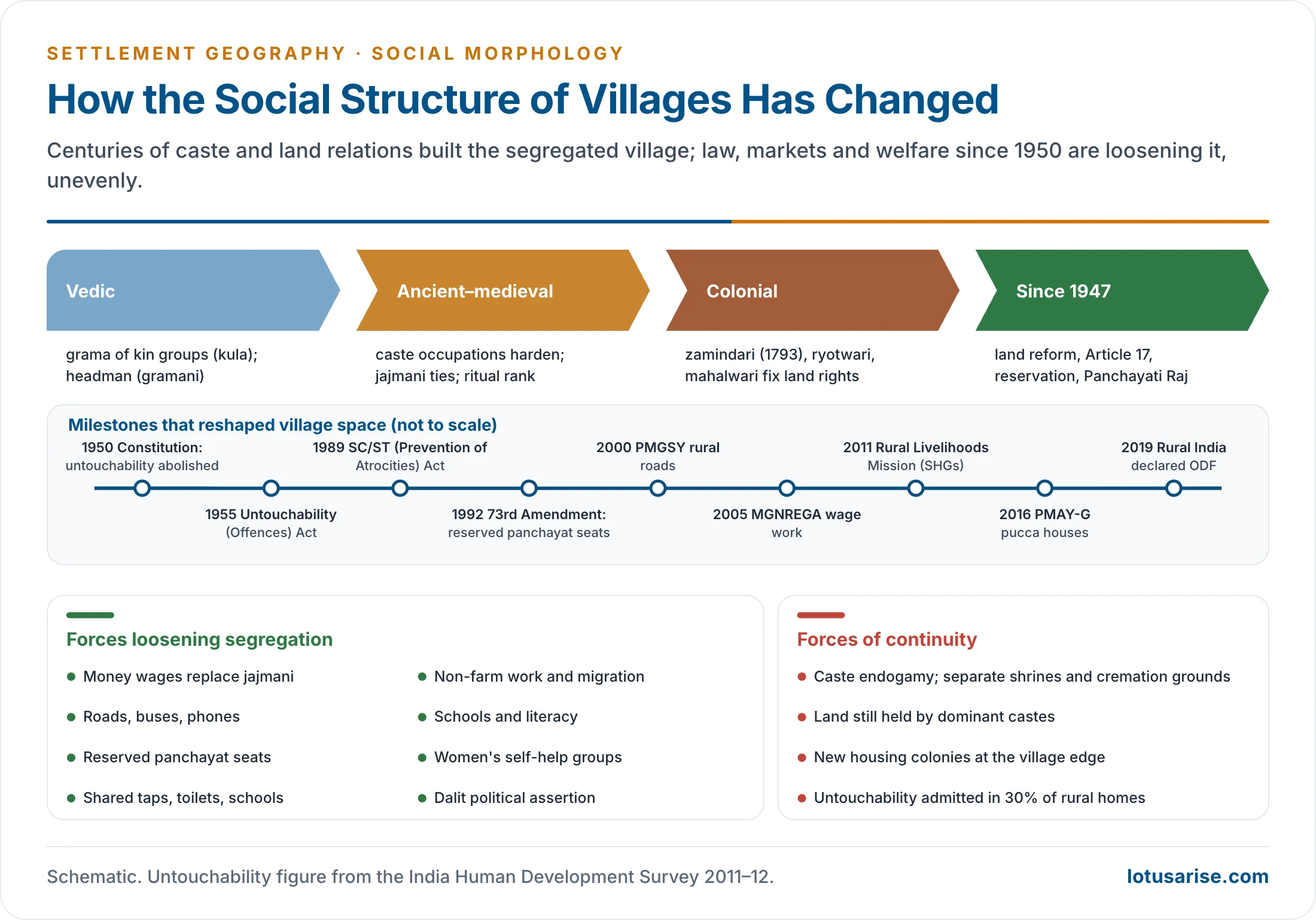
- Vedic period: the grama was organised around kinship groups (kula) under a headman (gramani). The emphasis was on functional unity more than rigid hierarchy.
- Ancient and medieval periods: with a settled agrarian economy, caste-based occupations hardened. Settlements began to show hierarchical segregation: ritual purity decided proximity to the centre.
- Colonial period: zamindari, ryotwari and mahalwari settlements fixed land rights on paper. They froze inequality in land ownership and with it the power of landowning castes over village space.
- After independence:
- zamindari abolition and land reforms;
- the abolition of untouchability (Article 17);
- reservation;
- Panchayati Raj (73rd Amendment, 1992).
- All of these attacked the old order, but traditional structures still shape village space.
Functional Space and Social Space
- The socio-spatial structure of a village can be read through two overlapping kinds of space:
- Functional space: the space of work and exchange. Fields, threshing floors, wells, markets and the houses of patrons and clients are linked by daily flows of labour, produce and services.
- It pulls groups together, because the landowner, the tenant, the labourer and the artisan need one another.
- Social space: the space of status and identity. Each caste, kin group or religious community keeps a recognised place, with its own lanes, shrines, wells and burial or cremation grounds.
- It keeps groups apart, because ritual rank and endogamy set limits on contact.
- Functional space: the space of work and exchange. Fields, threshing floors, wells, markets and the houses of patrons and clients are linked by daily flows of labour, produce and services.
- Physical distance in the village is therefore a measure of social distance. Where the two kinds of space coincide, the village is compact. Where social space dominates, it breaks into hamlets.
Spatial Expression of Caste
Caste-Based Spatial Organisation
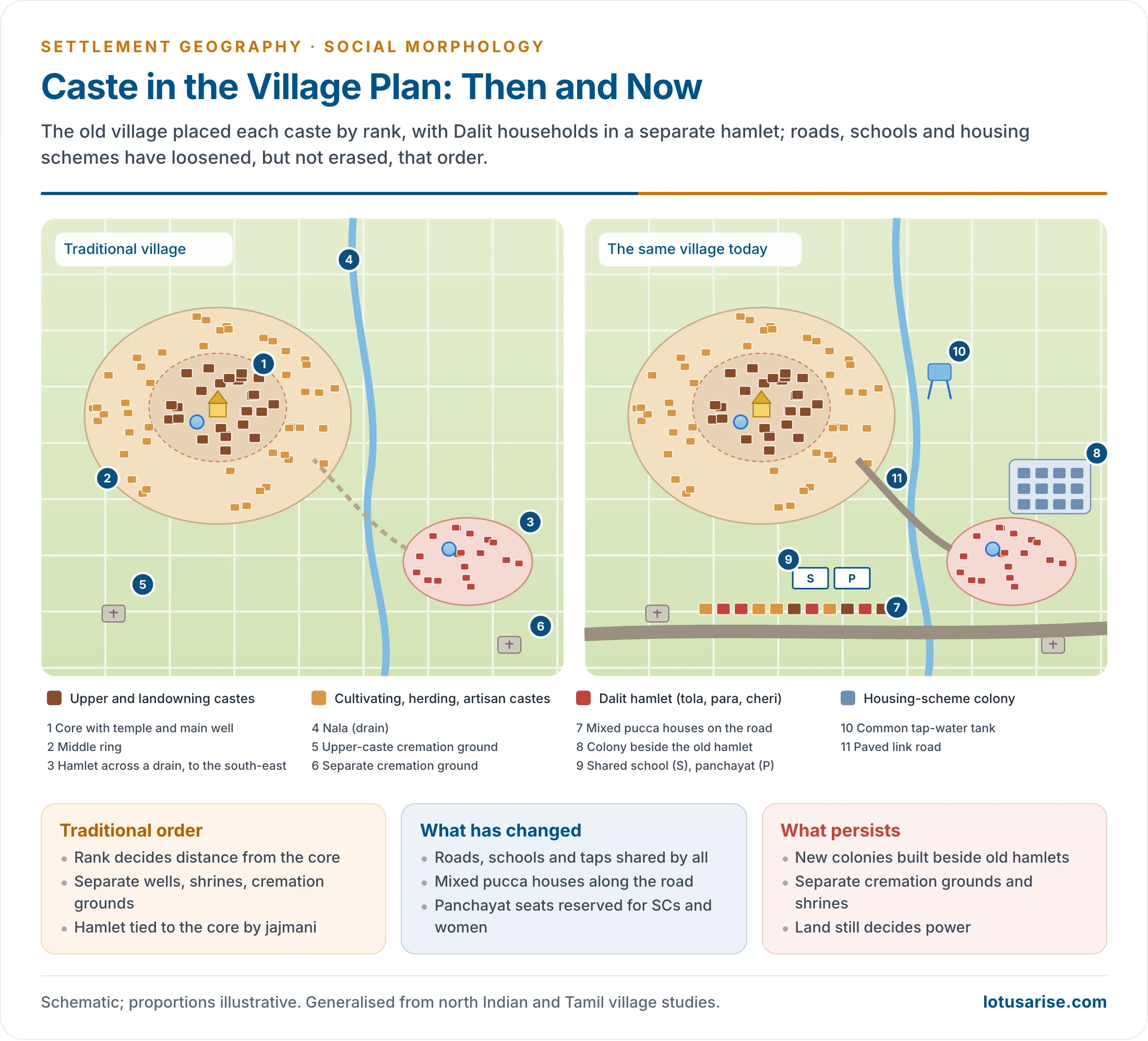
- Caste hierarchy is mapped onto the village plan:
- Dominant or upper castes occupy the central, higher and better-drained part, close to the temple, main well and chaupal.
- Their houses are large, often with courtyards and separate rooms for each married couple.
- Cultivating, herding and artisan castes (Kurmi, Yadav, Lohar, Badhai, Kumhar, Nai and others) live in a middle ring around the core.
- Dalit and landless households live at the periphery or in separate hamlets across a field, road or drain.
- They often live in one-room kutcha houses shared with livestock.
- Dominant or upper castes occupy the central, higher and better-drained part, close to the temple, main well and chaupal.
- Segregation extended to amenities: separate wells, temples, cremation grounds and even paths, under rules of purity and pollution.
- It was commonly believed that Dalit hamlets should lie to the south, south-east or east, downwind of the main village, since even air was thought to be polluted by contact with a Shudra. This was a direction treated as ritually inferior.
- The separate hamlets carry regional names:
| Region | Name of hamlet or ward | Notes |
|---|---|---|
| Bihar, eastern Uttar Pradesh | Tola, purwa | Often named after a caste (Chamar tola, Ahir tola) |
| Western Uttar Pradesh, Haryana, Punjab | Majra, patti, basti | Pattis are kin-based wards of large Jat villages |
| West Bengal, Odisha, Chhattisgarh | Para, pali | Bagdi para, Bauri para in Bengal villages |
| Maharashtra | Wadi, wada | Maharwada was the Dalit ward of the old village |
| Rajasthan | Dhani | Scattered homesteads of a lineage or caste |
| Tamil Nadu | Agraharam, ur, cheri | Brahmin street, main village, Dalit settlement |
| Keralam (Kerala), Andhra Pradesh | Colony, palle | Post-1970s housing colonies for SC households |
| Northern plain, by caste name | Ahyiron, Chamarkheda, Jatvara, Ladhian, Posiwada, Machpara | Common names for purvas of particular castes |
Regional Variations
- Middle Ganga plain (eastern Uttar Pradesh, Bihar):
- Large villages with a main settlement of landowning castes (Rajput, Bhumihar, Brahmin, Yadav or Kurmi, depending on the locality) and many tolas of other castes scattered among the fields.
- It shows the hamleted form at its clearest.
- Upper Ganga plain, Haryana and Punjab:
- Compact, fortress-like villages dominated by Jat or other landowning castes, divided into pattis (lineage wards).
- Dalit households live in a separate basti at one edge.
- Tamil Nadu and the Kaveri delta:
- A dual village: the ur of caste Hindus, with a Brahmin agraharam in older villages, and a physically separate cheri for Dalits, often with its own temple and burial ground.
- Deccan (Maharashtra, Karnataka): compact villages with a gaothan, where the Dalit ward (Maharwada in Maharashtra) lay just outside the old village wall or gate.
- Keralam: dispersed homesteads with little nucleation. In the past, caste distance was enforced through rules of approach rather than separate hamlets. Today SC families are concentrated in “colonies” created by land reform and housing schemes.
- Bengal and Odisha: villages of separate paras (neighbourhoods) of different castes and communities, strung along embankments and raised ground.
- Tribal belt and the North-East: caste is absent or weak, and villages are organised by clan and lineage.
- The pattern is therefore sharpest in the Ganga plain and the Tamil delta, and weakest in tribal, hill and dispersed-homestead regions.
Kashi Nath Singh’s Two Models
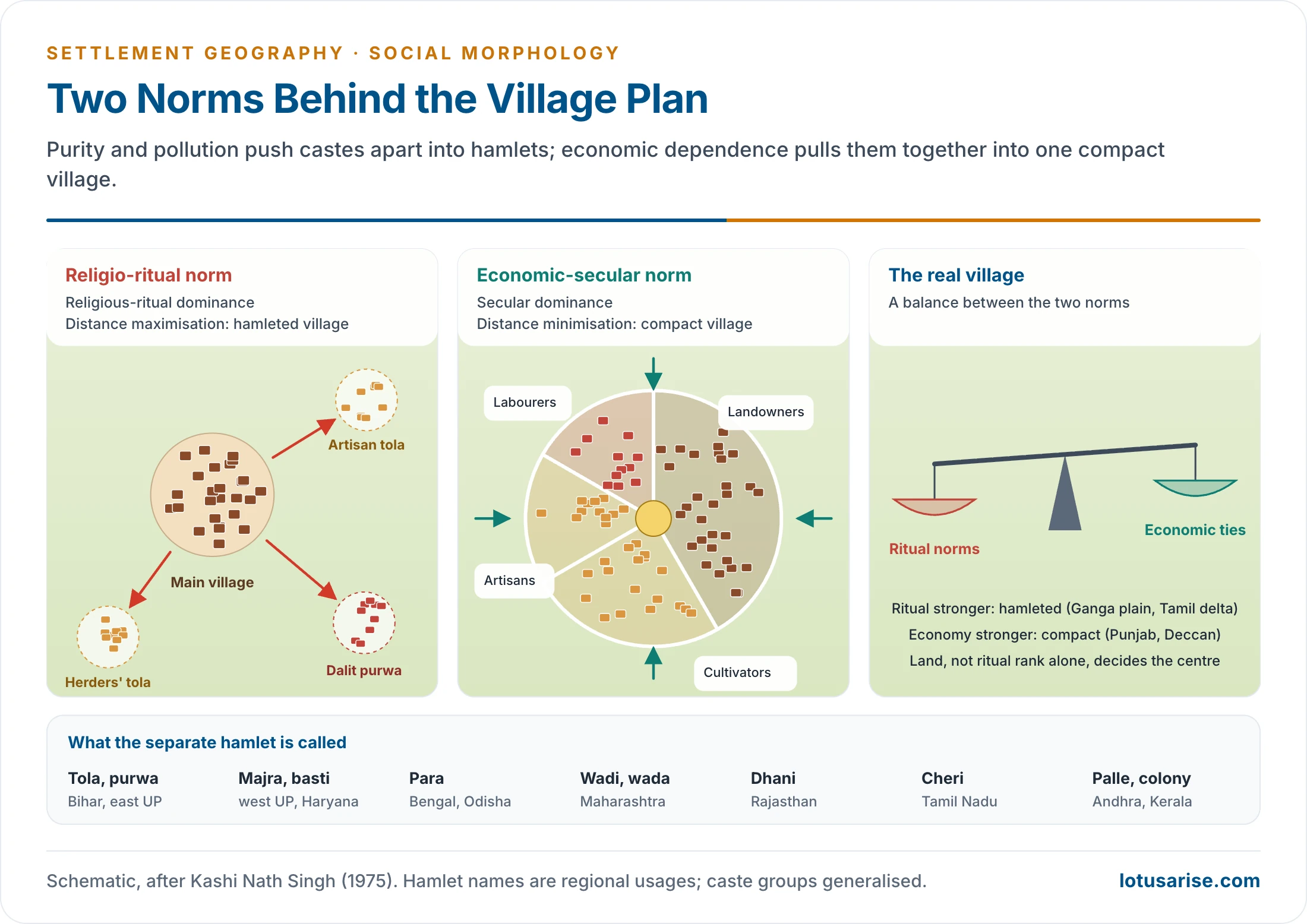
- Kashi Nath Singh (1975) read the Indian village as the balance of two opposing norms:
- Religio-ritual (religious-ritual dominance) model: distance maximisation.
- Rural Hindu society divides into castes with set roles: Brahmins ritual, Kshatriyas security, Vaishyas trade, commerce and farming, Shudras services, barred from many ritual privileges.
- The village splits into a twin settlement of caste Hindus and outcastes.
- The ideas of purity and pollution push “polluting” castes as far as possible from the upper castes.
- The result is hamleted villages, with separate purwas or tolas for Dalit and other lower castes.
- Economic-secular (secular dominance) model: distance minimisation.
- Landowners need labour, and labourers need land and patronage. Economic dependence pulls castes close together.
- The result is a compact, nucleated village, with castes in separate wards but within one built-up area.
- Religio-ritual (religious-ritual dominance) model: distance maximisation.
- The real plan of a village is an equilibrium between the two. Where ritual norms dominate, it is hamleted. Where economic ties dominate, it is compact.
- Power follows land as much as ritual rank.
- In Oscar Lewis’s study of Rampur, a Jat village near Delhi (1958), landowning Jats, not Brahmins, held the centre and the power.
- M.N. Srinivas (1955) called such groups the dominant caste: a caste strong in numbers and land, and reasonably placed in ritual rank.
Jajmani System and Economic Interdependence
- The jajmani system, described for a north Indian village by William H. Wiser (1936), bound castes in hereditary patron–client exchange:
- The jajman, usually a landowning family, received services.
- The kamin or service castes provided them: barbering, pottery, carpentry, blacksmithing, washing and leatherwork.
- Payment was mostly in kind: a share of grain at harvest, food and clothing at festivals.
- The system explains why service castes lived near the core while remaining socially subordinate, and why main village and hamlets worked as one functional unit.
- It gave security and mutual dependence, but it fixed hierarchy and blocked occupational mobility.
Other Features of Social Morphology
- Community bonding and cohesion:
- Cooperation in farm work, festivals, rituals and village decisions.
- The joint family gives economic security and social support, and keeps tradition alive.
- Village life is personal and face-to-face, unlike the anonymity of the city.
- Hereditary occupations and limited mobility: occupation was caste-based and hereditary. Even as work diversifies, this legacy still marks village space.
- Stratification and inequality: hierarchy rests on caste, land and wealth. It shows in unequal access to water, land and common resources, in caste endogamy and in social exclusion.
- Religion and cultural institutions:
- Temples, mosques, shrines, sacred groves and ponds, and festival grounds anchor the village.
- The gram devta (village deity) and shared festivals bind the community. Separate shrines can also mark social distance.
- Shared spaces and infrastructure:
- Kutcha or semi-pucca lanes, wells, tanks, grazing grounds, cattle sheds and granaries.
- These are common resources, showing collective ownership and dependence on nature.
- Access to them has always been unequal across castes.
Religion, Ethnicity and Gender in Village Space
- Religious communities form their own wards in mixed villages:
- Muslim mohallas or tolas, with a mosque, madrasa and graveyard, are common in villages of Uttar Pradesh, Bihar and West Bengal.
- Christian quarters with a church are common in Keralam, Goa and parts of the North-East.
- Sikh, Hindu and Dalit (often Ravidassia) gurdwaras stand in separate wards of many Punjab villages.
- Each community’s sacred site acts as a local nucleus, so a mixed village can have several centres.
- Gender shapes the use of space:
- In the north, seclusion of women produced inward-looking houses with an inner courtyard and an outer sitting place (baithak, chaupal) for men.
- Women’s daily paths ran to wells, ponds, fields and fuel sources. This is why piped water and toilets change women’s use of village space most of all.
- Public spaces such as the chaupal and panchayat ghar were male domains. Reserved seats in panchayats are slowly opening them to women.
Social Morphology of Tribal Villages
- Tribal villages follow clan and lineage more than caste. Hierarchy is weaker, and the village is organised around shared ritual and youth institutions:
- Santal villages are often laid out along a single street, with the headman’s shrine (manjhi than) in the village and a sacred grove (jaher than) at its edge.
- Muria Gond villages of Bastar had the ghotul, a youth dormitory at the centre of village social life.
- Naga villages stand on ridge tops, divided into khels (clan wards), each with its morung (bachelors’ dormitory and guard house).
- Bhil settlements are dispersed: houses stand on separate hillocks amid their fields and group into phalias (hamlets) of one lineage.
- Among the matrilineal Khasi, the house and property pass through the youngest daughter. Clan ties, not caste, order the village.
- Sacred groves, dance grounds (akhra) and common fields are collectively owned. Where non-tribal settlers have moved in, caste-type segregation appears at the edges of tribal villages.
Scholarly Interpretations
- O.H.K. Spate (1952) found Deccan villages compact and nucleated:
- The causes were defence in the past, cooperation in farming and scarce water.
- Houses stood wall to wall around courtyards used for storage and drying grain.
- Dominant castes held the centre, and lower castes lived on the outskirts.
- Village form reflected both social hierarchy and ecological adaptation.
- Kathleen Gough studied Kumbapettai, a Brahmin-dominated village in Thanjavur, from fieldwork in the early 1950s.
- Brahmin landowners lived in the agraharam, a street of houses in rows near the temple, symbolising both ritual purity and economic power.
- Non-Brahmin tenants lived in separate streets, and the Dalit labourers lived in a separate cheri.
- Space was structured by power, land ownership and ritual status.
- Irawati Karve gave a regional typology for Maharashtra:
- Nucleated villages of the Deccan, surrounded by fields, reflecting the need for protection, efficient land use and social cohesion;
- Linear villages of the Konkan, strung along a road or the coast amid coconut and fruit groves, with little separation of house and field;
- Segmented villages of north-west Maharashtra, broken into wadis of single castes or kin groups, with lower castes at a distance.
- Regional ecology and social organisation jointly decide village form.
- Santibhushan Nandi and D.S. Tyagi, in the Anthropological Survey of India’s Peasant Life in India, classed village forms across the country:
- Shapeless or amorphous clusters in the Ganga plain, Rajasthan and Malwa;
- Linear villages along roads, rivers and canals in coastal Odisha, Andhra Pradesh and Gujarat;
- Rectangular or grid villages in dry areas such as Rayalaseema;
- Isolated homesteads in tribal and remote areas, treated administratively as villages.
- R.B. Mandal (1979) compared rural settlement worldwide:
- Compact villages in monsoon Asia (dense population, intensive farming);
- Dispersed farmsteads in North America (large, mechanised holdings);
- Semi-compact, often planned villages in Europe;
- Semi-sprinkled or linear forms in parts of Africa and South America.
- Climate, land availability, farming practice and culture together decide form.
| Scholar | Area | Key idea |
|---|---|---|
| O.H.K. Spate (1952) | Deccan | Compact villages; dominant castes at the centre |
| Kathleen Gough | Thanjavur | Agraharam, non-Brahmin streets and cheri: space follows ritual and land |
| Irawati Karve | Maharashtra | Nucleated, linear and segmented (wadi) villages |
| Nandi and Tyagi | All India | Shapeless, linear, rectangular forms and isolated homesteads |
| Kashi Nath Singh (1975) | Ganga plain | Ritual distance maximisation versus economic distance minimisation |
| R.B. Mandal (1979) | World | Form follows climate, land, farming and culture |
Contemporary Changes
Weakening of Segregation
- The old spatial division is loosening because of:
- constitutional safeguards (Article 17), the Untouchability (Offences) Act, 1955 (renamed the Protection of Civil Rights Act in 1976) and the SC/ST (Prevention of Atrocities) Act (1989);
- spread of education and awareness, and Dalit political assertion;
- state housing: PMAY-G gives priority to SC/ST and landless households, and its houses look the same whoever lives in them.
- Yet segregation persists, especially in northern India and the Tamil countryside.
- In the India Human Development Survey (2011–12), 30% of rural households (27% overall) admitted practising untouchability in some form.
- Many housing colonies for Dalit households were built at the edge of the village, repeating the old pattern in new concrete.
- Separate cremation grounds and temple access remain flashpoints.
Decline of the Jajmani System and Occupational Change
- The jajmani system has largely collapsed under:
- monetisation of the rural economy and wage labour;
- commercial farming and machines (tractors, harvesters);
- urban jobs, MGNREGA (2005) and seasonal and circular migration.
- Hereditary occupations have declined, and non-farm work (construction, transport, trade, services) has grown.
- The result is weaker inter-caste economic dependence and greater mobility, though uneven across regions and classes.
Rural–Urban Linkages and Housing
- PMGSY roads (2000), buses, mobile phones and markets tie villages into a rural–urban continuum, with peri-urban growth and urban lifestyles.
- Kutcha mud and thatch houses give way to pucca brick and cement, driven by remittances, rising incomes and PMAY-G.
- Houses move to the roadside, livestock is separated from living space, and compact villages loosen. Better village lanes, sanitation and urban aspirations come with the change.
Family, Power and Gender
- Nuclear families are replacing joint families. Youth migrate, collective farm labour declines, and individualism and privacy grow.
- Panchayati Raj (73rd Amendment, 1992) reserves seats and chair posts for SCs, STs and women.
- Women now make up nearly half of elected panchayat members, and many States reserve 50% of seats for them.
- New leaders challenge the hold of traditional elites, though proxy rule by male relatives persists.
- Education has created a rural middle class and weakened caste-bound occupations.
- Self-Help Groups under the Deendayal Antyodaya Yojana–National Rural Livelihoods Mission bring about 10 crore rural women into savings, credit and enterprise. With better access to schooling and health care, this raises their economic independence and social visibility.
- Digital India, Common Service Centres and digital payments link villages to wider markets and services.
Continuity amid Change
- Many traditional features endure:
- caste identity still shapes marriage, worship and residence;
- land ownership still decides power;
- social exclusion is still visible in the location of hamlets and amenities.
- Rural social morphology today is a hybrid: an old caste-ordered core and outlying hamlets, overlaid by roadside pucca housing, state colonies and new institutions.
- The distribution of Scheduled Castes and Scheduled Tribes gives the regional background:
- About three-quarters of India’s Scheduled Caste population and nine-tenths of its Scheduled Tribe population live in villages (Census 2011).
Previous Year Questions
2018Describe the changing regional morphology of rural settlements in India.2023“Rural settlements are expressions of the basic relationships between human beings and their physical and social environment.” Discuss.2025“The rural settlements in India are highly diversified due to both physical and cultural factors.” Justify the statement with examples.




