

- Pipelines are the most convenient and suitable means of moving petroleum products and gases in bulk over long distances, and they can also carry water and solids turned into slurry.
- From about 5,035 km in 1980, India’s oil network grew to 10,443 km of crude lines and 24,864 km of product lines on 1 September 2026. The National Gas Grid adds about 27,905 km of operating gas lines (31 March 2026).
- Their geographic importance lies in carrying energy away from coasts and oilfields into the interior, so refineries, fertiliser plants and power stations can locate far from the source.
Pipeline Transport in India
What Pipelines Carry
- Petroleum products: crude oil, jet fuel.
- Liquid products: water, anhydrous ammonia, and even milk.
- Gases: natural gas, LPG, butane.
- Solid products: coal, minerals and solid wastes, converted into slurry first.
Advantages and Disadvantages of Pipelines
Advantages
- Low energy use: far less than other modes.
- Minimal transit losses.
- Low running cost: often put at under one-tenth of surface transport. Maintenance is also light.
- Little wastage of material, as with slurry of coal and iron ore.
- Difficult ground and water: lines can cross difficult terrain and run underwater, where other modes cannot go.
- Weather-proof: seasonal changes and hostile climate, such as flood, snowfall and rain, do not stop them.
- Slurry examples:
- Bailadila produces high-grade ore that was exported through Visakhapatnam Port. A slurry line of about 270 km (267 km in current records) now brings the ore from the mine to the Visakhapatnam area, and this has relieved the road route.
- Kudremukh ore was mined on a large scale for export through New Mangalore port, moved over a slurry line of about 70 km (67 km on a 2002 government count). Mining at Kudremukh closed in 2006.
- Rock phosphate concentrate moves by slurry line from the Maton mines to the Debari smelter in Rajasthan.
- Safe, accident-free and environmentally friendly.
- Industry nearby: lines bring about development in adjoining areas, as with fertiliser plants on the gas pipeline at Jagdishpur and Shahjahanpur.
- Relief to surface transport: by taking fuel off the rail and road systems, they free those networks for other cargo.
Disadvantages
- Earthquakes can distort pipelines, and leaks and cracks are then very hard to find.
- High first cost: laying a line costs a great deal, although upkeep is cheap.
- Security threats:
- Terrorist organisations can threaten a line and a country’s economy with it.
- Transboundary pipelines are especially exposed, such as TAPI, which faced threats from groups based in Pakistan and Afghanistan.
- Oil pipelines in the north-east have often been blasted by anti-national elements.
- Fixed capacity: capacity cannot be raised once laid, and more needs new lines.
- Difficult repair: finding and mending leaks is hard, especially underground.
- Inflexible: a line serves only a few fixed points and carries one kind of cargo in a set direction.
| Feature | Pipeline | Rail | Road |
|---|---|---|---|
| Cargo | Liquids, gases, slurry | Bulk and general | General, small lots |
| Reach | Fixed corridors | Fixed network | Door to door |
| First cost | High | High | Lower |
| Running cost | Very low | Low | High |
| Weather risk | Very low | Moderate | Higher |
Major Pipelines of India
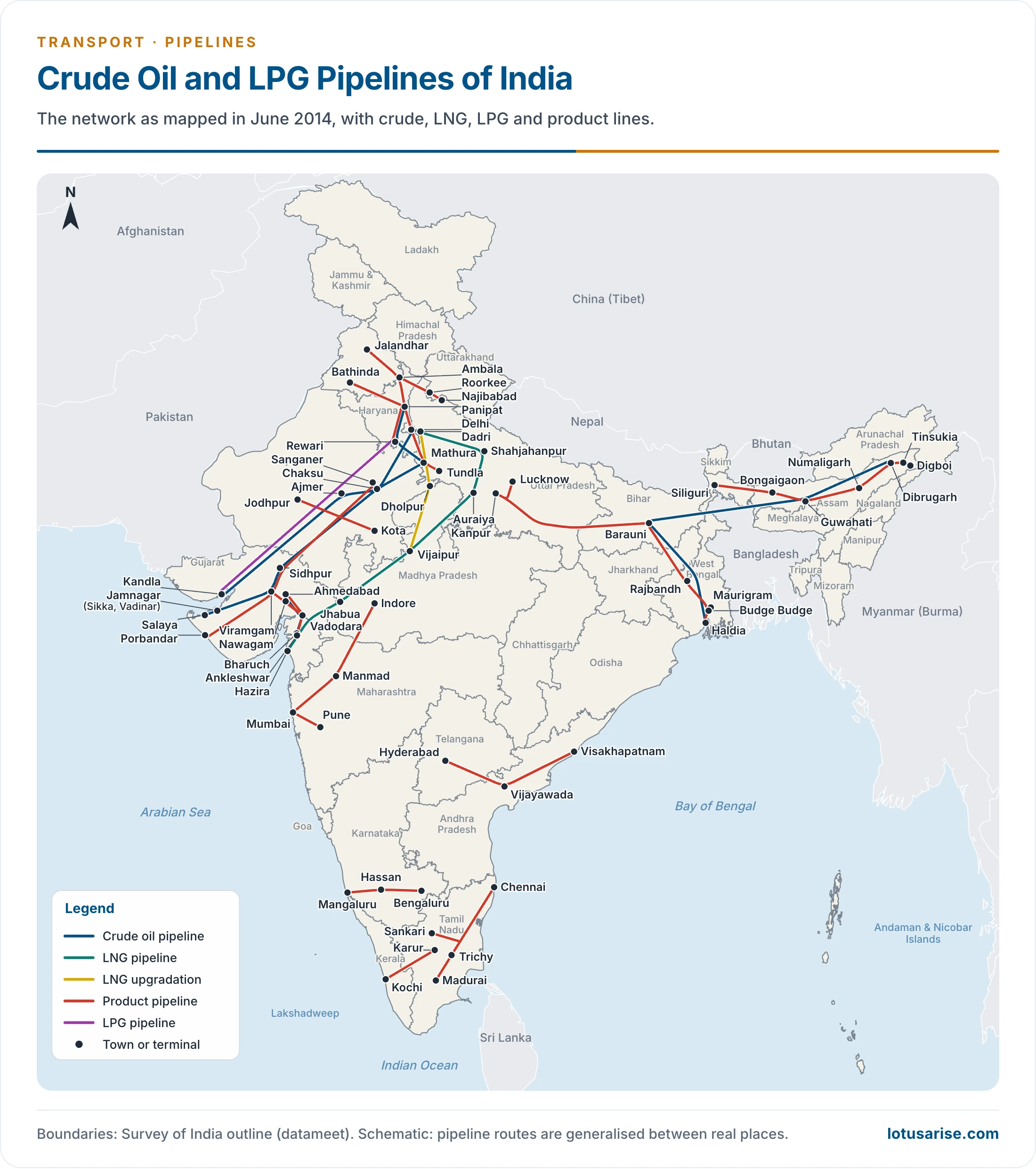
- Transport by pipeline is a recent development in India, and it remains limited to specific corridors.
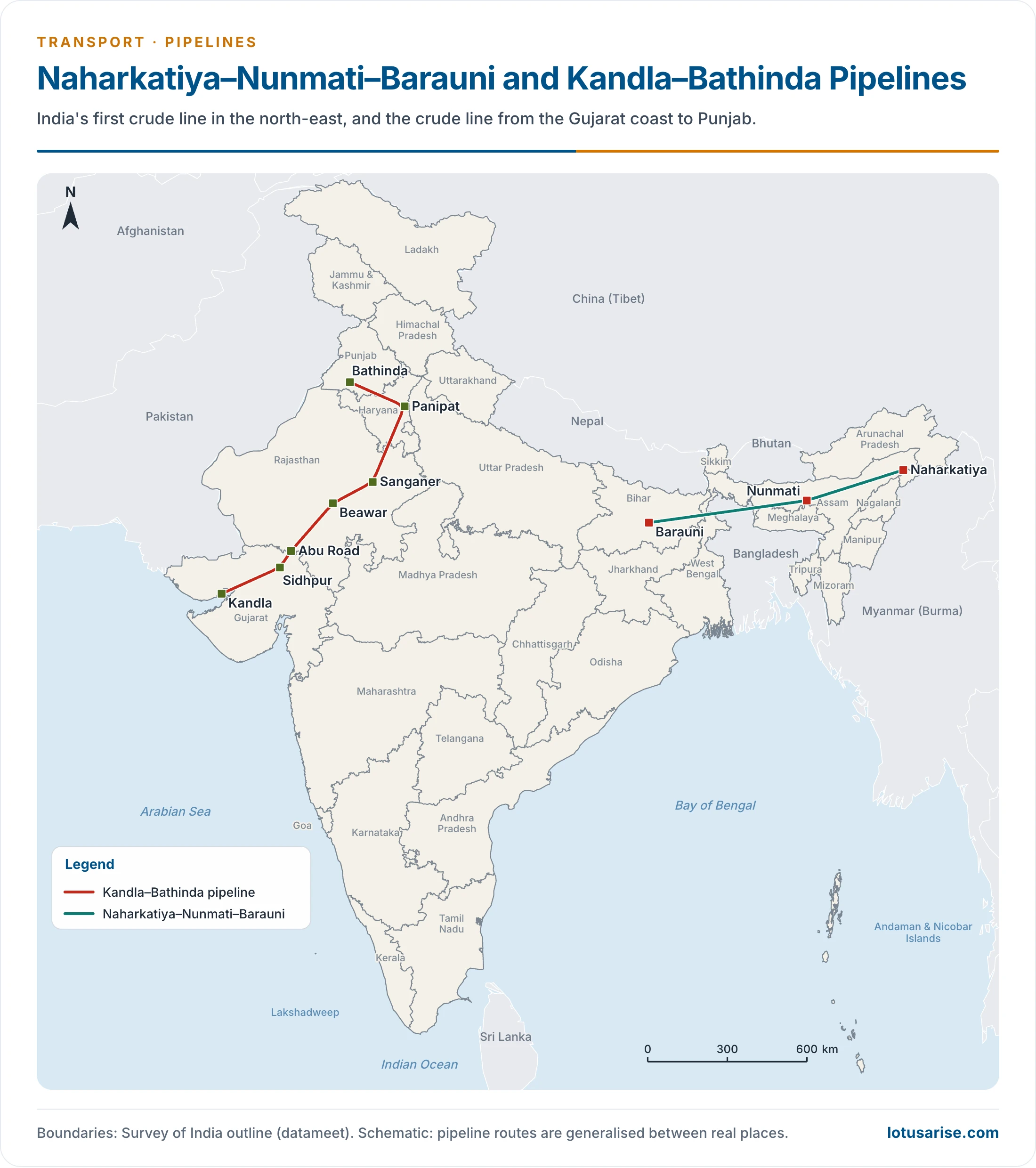
Naharkatiya–Nunmati–Barauni Pipeline
- India’s first pipeline, built by Oil India Limited to bring crude from the Naharkatiya oilfield in Assam to the Nunmati refinery, and on to Barauni refinery in Bihar.
- The Naharkatiya–Nunmati section opened in 1962, Nunmati–Barauni in 1964, and the whole line runs 1,167 km.
- Its subsidiary lines add capacity:
- Nunmati–Siliguri: oil from Nunmati (Guwahati) in Assam to Siliguri in West Bengal.
- Lakwa–Rudrasagar–Barauni: crude from Lakwa and Rudrasagar to Barauni.
- Barauni–Haldia: completed in 1966. It sends refined products to Haldia port, and it brings crude back to Barauni. Refined product then returns to Haldia for export.
- Barauni–Kanpur: refined products from Barauni to Kanpur.
- Nunmati–Bongaigaon: raw material for the Bongaigaon petrochemical complex.
- Haldia–Rajbandh–Maurigram: supplies the southern part of West Bengal.
Mumbai High–Mumbai Pipeline
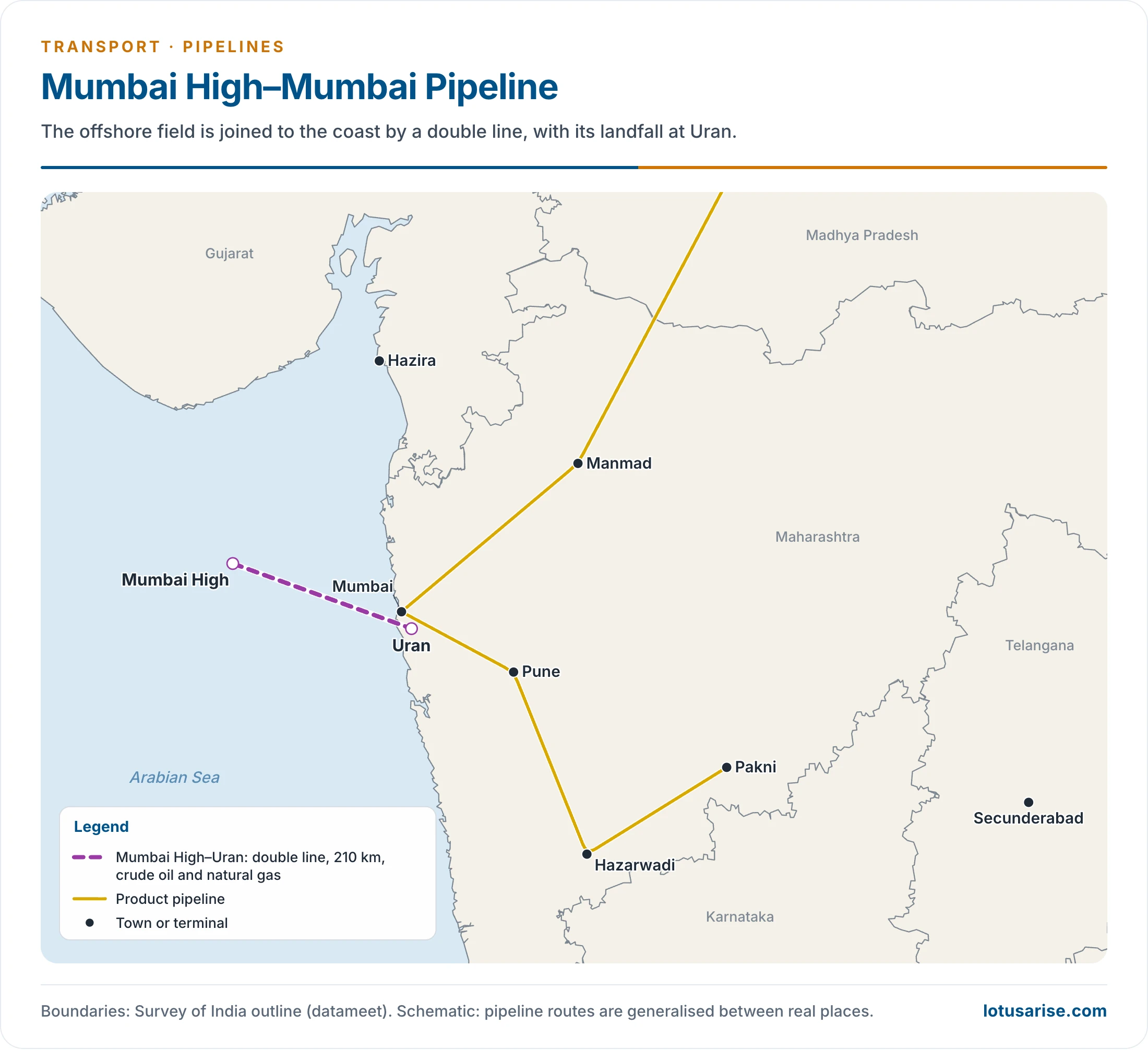
- A 210 km double line joins Mumbai with Mumbai High, for crude oil and natural gas. The landfall is at Uran.
Ankleshwar–Koyali Pipeline
- Completed in 1965, it takes crude from the Ankleshwar oilfield to Koyali refinery.
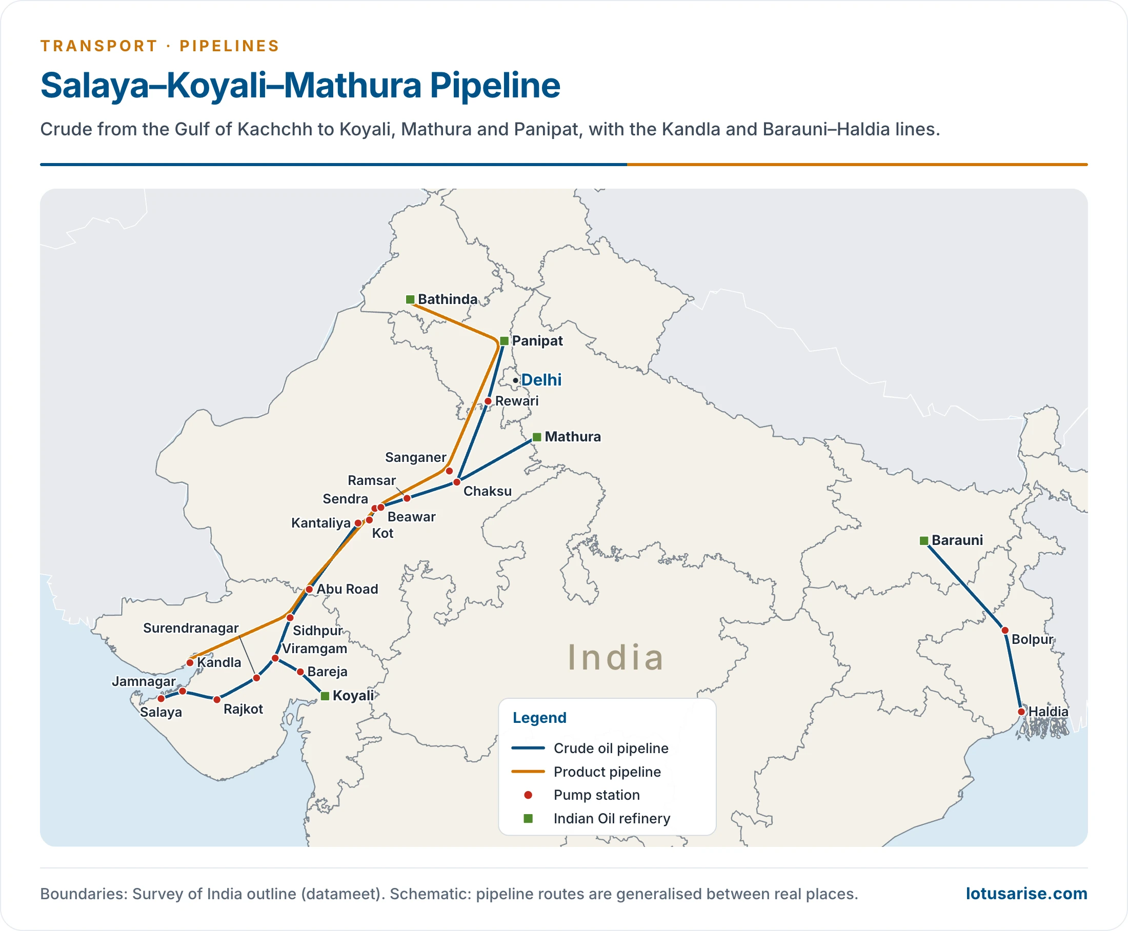
Salaya–Koyali–Mathura Pipeline
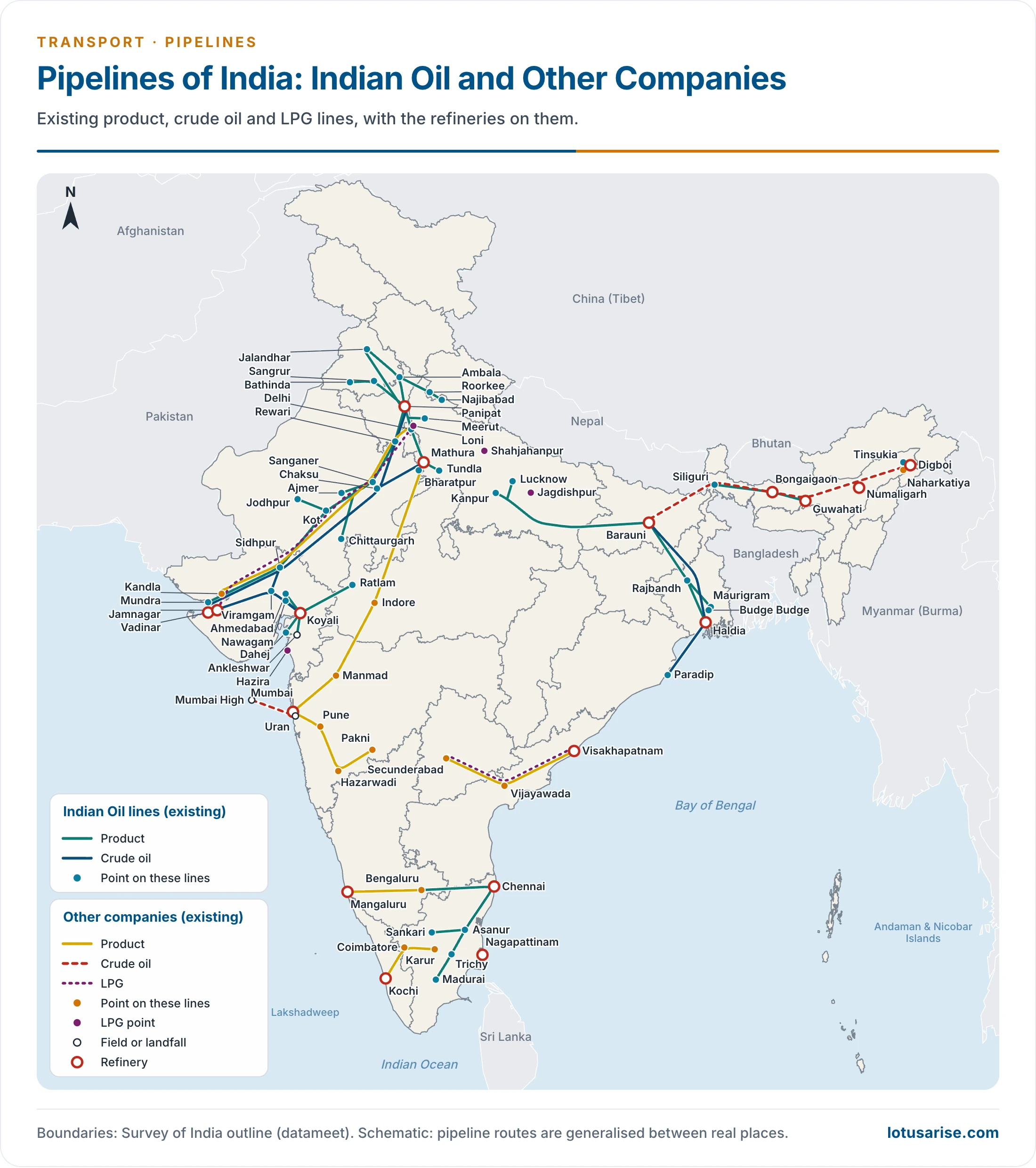
- It runs from Salaya in Gujarat to Mathura in Uttar Pradesh, through Viramgam.
- This 1,256 km line feeds crude to the Koyali and Mathura refineries.
- It has been extended from Mathura to Panipat in Haryana and Jalandhar in Punjab, and it has an offshore terminal for imported crude. With branches, Indian Oil now gives 2,663 km.
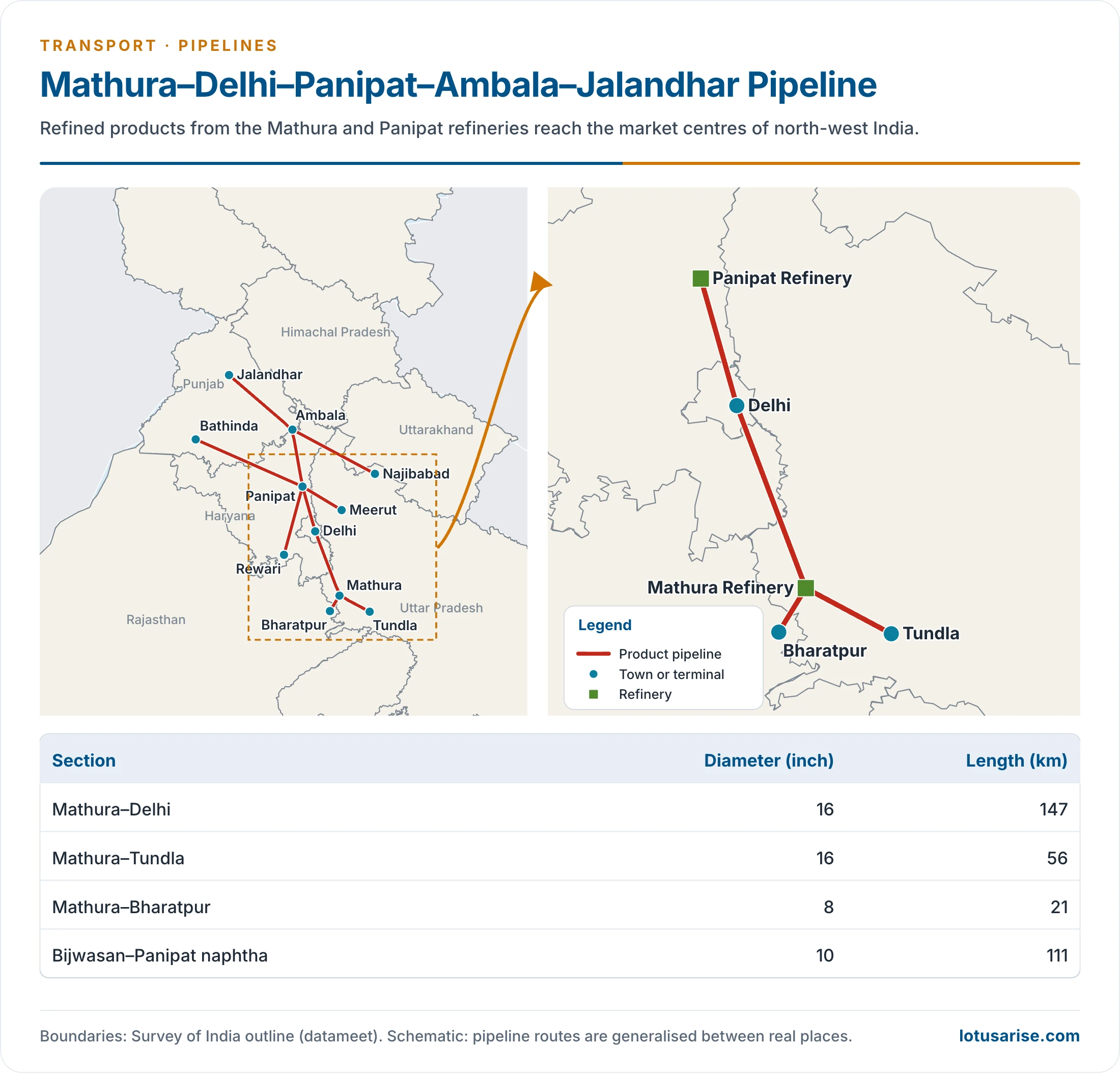
Mathura–Delhi–Panipat–Ambala–Jalandhar Pipeline
- It moves refined products of the Mathura and Panipat refineries to the market centres of north-west India.
Haldia–Kolkata Pipeline
- It carries refined petroleum products to Kolkata and its neighbourhood.
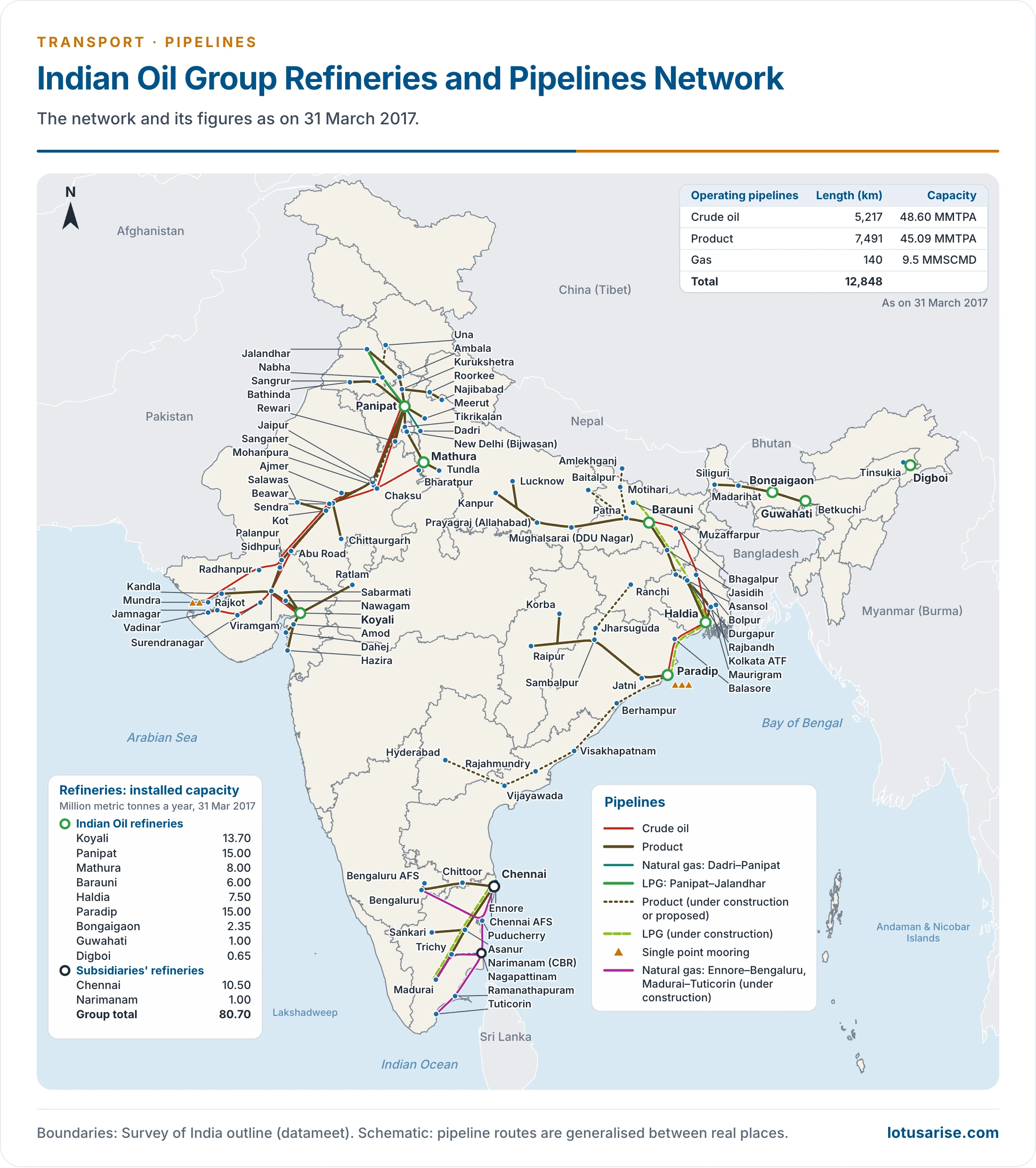
- The figures on this map date from 31 March 2017.
Hazira–Vijaipur–Jagdishpur (HVJ) Gas Pipeline
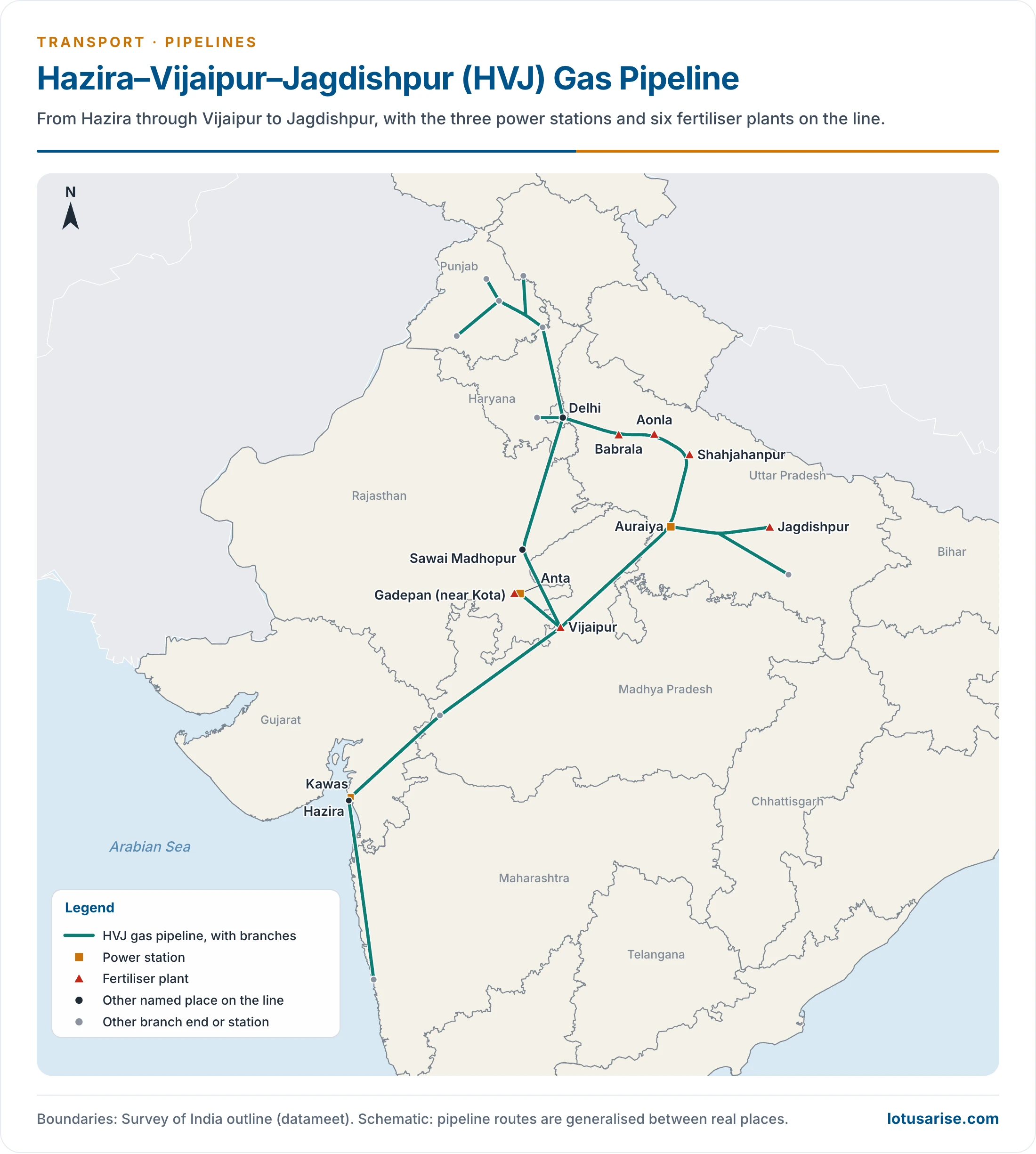
- Known earlier as Hazira–Bijapur–Jagdishpur (HBJ), it was built by Gas Authority of India Limited (GAIL) and long ranked as the longest gas pipeline in India.
- This 1,750 km line passes through Hazira and Kawas in Gujarat, Vijaipur in Madhya Pradesh, Auraiya, Jagdishpur, Shahjahanpur, Aonla and Babrala in Uttar Pradesh, and Anta, Sawai Madhopur and Kota in Rajasthan.
- Its daily flow of 18 million cubic metres of gas goes to:
- Three power stations: Kawas (Gujarat), Anta (Rajasthan) and Auraiya (Uttar Pradesh).
- Six fertiliser plants: Vijaipur, Gadepan near Kota (listed in older accounts under Sawai Madhopur), Jagdishpur, Shahjahanpur, Aonla and Babrala.
- Each fertiliser plant was built for an output of 1,350 tonnes of ammonia a day.
- It is a unique engineering feat, built for over ₹1,700 crore. It crosses 343.7 km of rocky ground and 56.3 km of forest, along with 29 railway crossings and 75 big and small rivers.
- Described in its day as the world’s largest underground pipeline, it reshaped economic life across Gujarat, Madhya Pradesh, Rajasthan and Uttar Pradesh.
- Extended to Delhi to meet the capital’s growing demand.
Jamnagar–Loni LPG Pipeline
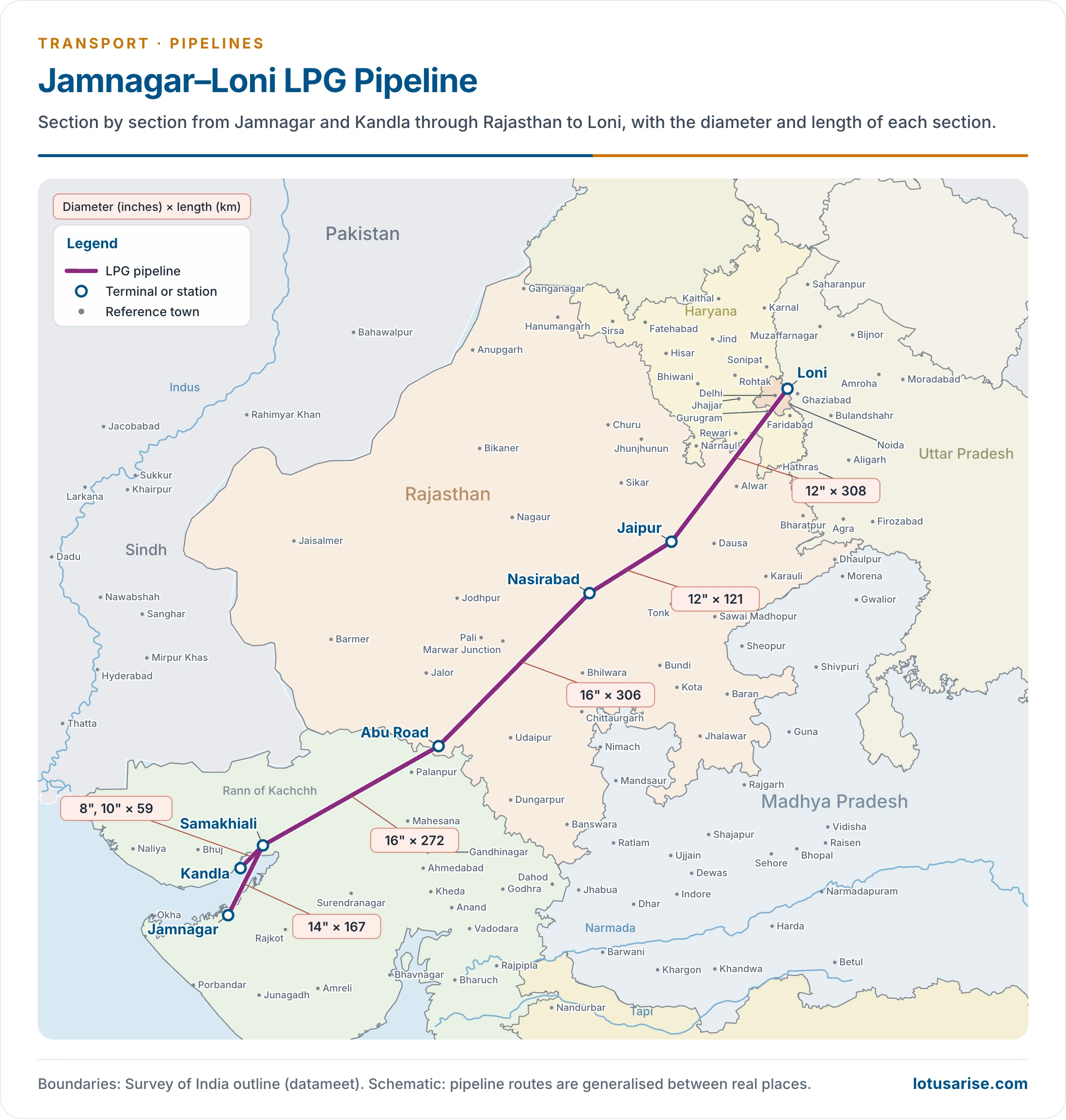
- A 1,269 km line built by GAIL, joining Jamnagar in Gujarat with Loni near Delhi in Uttar Pradesh, through Gujarat, Rajasthan, Haryana and Uttar Pradesh. The authorised length now stands at about 1,414 km.
- It was long called the longest LPG pipeline in the world, and the Kandla–Gorakhpur LPG line (about 2,757 km) is now India’s longest.
- It is equal to moving 3.5 lakh LPG cylinders a day over 1,269 km, with capacity being raised to 5.0 lakh.
- It saves about ₹500 crore a year by removing road tankers, and it cuts about 10,000 tonnes of pollutants a year.
- It was the first cross-country pipeline for LPG, bringing better supply, safety and wider distribution.
- Bottling points along the route are Ajmer and Jaipur (Rajasthan), Piyala (Haryana), Madanpur Khadar (Delhi) and Loni (Uttar Pradesh).
- Phase I was finished in 2001 and Phase II in 2003.
Kandla–Bathinda Pipeline
- Planned at 1,331 km by Indian Oil (IOC), at an estimated ₹690 crore, to carry crude to the refinery proposed at Bathinda.
- Current records give the built line as about 1,443 km. Bathinda’s refinery now runs as Guru Gobind Singh Refinery.
Other Pipelines
- In Gujarat: the Kalol–Sabarmati and Nawagam–Kalol–Koyali crude lines, Cambay–Dhuvaran, Ankleshwar–Uttaran and Ankleshwar–Vadodara gas lines, and the Koyali–Ahmedabad product line.
- Around Mumbai: product lines to Pune and Manmad.
- Product lines elsewhere: Visakhapatnam–Secunderabad (600 km), Kanpur–Bina, Mangaluru–Chennai, Vijayawada–Visakhapatnam and Haldia–Budge Budge.
- Chennai–Trichy–Madurai was dedicated on 26 June 2006, and Mundra–Delhi (1,054 km) on 2 February 2009.
- Barmer–Salaya carries Rajasthan crude to the Gujarat coast over about 590 km.
National Gas Grid
- GAIL’s older plans named Dahej–Vijaipur, Dahej–Hazira–Uran and Kochi–Mangaluru–Bengaluru, and a 6,000 km grid on the National Highways pattern. That idea has since become the National Gas Grid.
| Measure | Figure | Date |
|---|---|---|
| Operating gas lines | About 27,905 km, including tie-ins and dedicated lines | 31 March 2026 |
| GAIL’s common-carrier lines | 18,302 km; older count 14,800 km | 31 March 2026 |
| Authorised gas lines | 34,233 km, of which 10,459 km under construction | June 2025 |
| Grid target | About 35,000 km | Target |
| Gas in energy mix | 15% by 2030 | Target |
- Pradhan Mantri Urja Ganga (Jagdishpur–Haldia–Bokaro–Dhamra): the eastern arm of the grid.
- Older plans gave 2,050 km for Jagdishpur–Haldia. The main line now runs over 2,096 km, and the authorised project with branches reaches 3,306 km.
- It was 97.6% laid by April 2025, and it takes gas into Uttar Pradesh, Bihar, Jharkhand, West Bengal and Odisha.
- Kochi–Mangaluru (450 km): dedicated on 5 January 2021.
- North East Gas Grid (about 1,656 km): Phase I opened on 13 March 2026.
- City Gas Distribution: 307 geographic areas were authorised, with 1.54 crore domestic piped gas connections and over 8,000 CNG stations by 2025. Gas thus reaches homes and vehicles in many inland districts.
- Cross-border lines:
- India–Bangladesh Friendship Pipeline (131.57 km, Siliguri to Parbatipur), inaugurated on 18 March 2023, sends diesel from Numaligarh’s supply system.
- TAPI and the abandoned Iran–Pakistan–India plan show how politics limits transnational routes.
- Trade in these fuels shapes the map of natural gas and petroleum lines.
Role of Pipelines in Regional Development
Pipelines as Growth Poles
- Pipelines are the best means of industrial dispersal in backward and depressed regions.
- A trunk line acts as a growth pole, with immense horizontal clustering of petrochemical and fertiliser industries along it.
- HVJ gave rise to three power plants at Kawas, Anta and Auraiya, and six fertiliser plants: Vijaipur (Madhya Pradesh), Gadepan (Rajasthan), and Jagdishpur, Shahjahanpur, Aonla and Babrala (Uttar Pradesh).
- Urja Ganga was tied to the revival of the fertiliser plants at Gorakhpur, Barauni and Sindri.
- Production meets consumption: pipelines link the geography of production with the geography of consumption, and economic development and regional growth follow.
- Refineries in backward areas: Barauni and Mathura could come up inland because pipelines made it possible. Without them, the refining industry would hug the ports.
Reducing Regional Imbalance
- Coast to interior: imported crude and LNG arrive on the west coast, and lines carry them to the Northern Plain and eastern India, far from any port.
- Eastern India: gas reaching Bihar, Jharkhand and Odisha gives an old mineral belt cleaner fuel for steel, fertiliser and city use.
- North-East: Assam’s oil long left the region, while the region itself lacked gas lines and consumers. The North East Gas Grid turns that one-way flow towards local use.
- Limits to the argument:
- Pipelines create few jobs once built, so the gain depends on the industries that follow.
- A line benefits places with a tap-off point. Districts along the route but without one gain little.
- Fuel demand is highest in developed regions, so the densest lines still serve Gujarat and the north-west.
Complementary Role with Other Networks
- Pipelines have a unique character: they carry few kinds of cargo over fixed corridors, so they mostly relieve rail and road instead of competing across the board.
- Jamnagar–Loni alone removed fuel tankers from long stretches of highway.
- The slurry line from Bailadila relieved the road route.
- They still rely on the others. Ports receive crude and LNG for them, and road tankers and rail wagons complete delivery from terminals to the last market.
- PM GatiShakti puts pipelines on the same planning map as roads and railways, so that corridors can be planned together.
List of Refineries in India
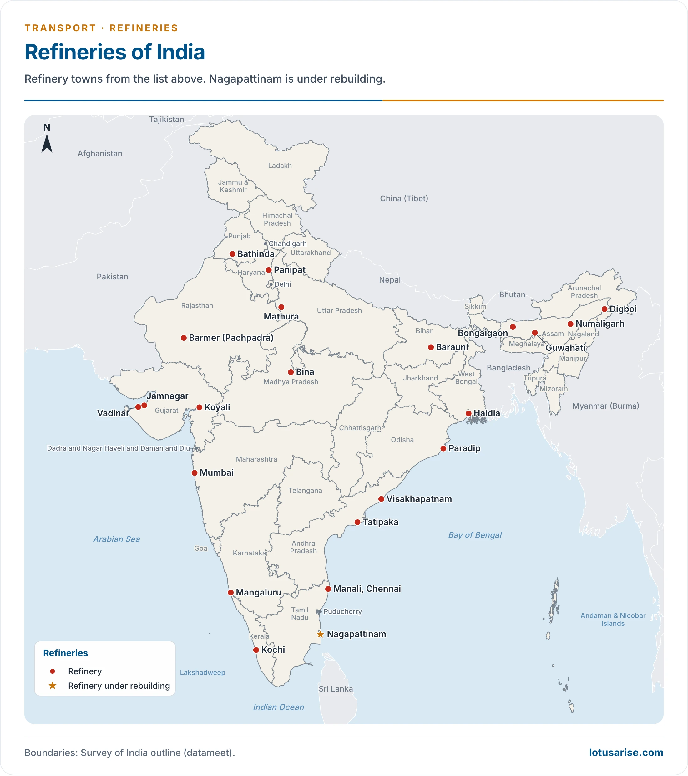
- Pipelines tie these refineries to fields, ports and markets. Capacities below stand on 1 April 2026, and they total 267.12 million tonnes a year.
| No. | Refinery | State | Location | Capacity (million tonnes a year) |
|---|---|---|---|---|
| 1 | Jamnagar Refinery | Gujarat | Jamnagar (SEZ) | 35.2 |
| 2 | Jamnagar Refinery | Gujarat | Jamnagar (DTA) | 33.0 |
| 3 | Nayara Energy Refinery | Gujarat | Vadinar | 20.0 |
| 4 | Kochi Refinery | Keralam (Kerala) | Kochi | 15.5 |
| 5 | Mangalore Refinery and Petrochemicals Limited | Karnataka | Mangaluru | 15.0 |
| 6 | Paradip Refinery | Odisha | Paradip | 15.0 |
| 7 | Panipat Refinery | Haryana | Panipat | 15.0 |
| 8 | Gujarat Refinery | Gujarat | Vadodara (Koyali) | 13.7 |
| 9 | Mumbai Refinery (Bharat Petroleum) | Maharashtra | Mumbai | 12.0 |
| 10 | Mumbai Refinery (Hindustan Petroleum) | Maharashtra | Mumbai | 9.5 |
| 11 | Guru Gobind Singh Refinery | Punjab | Bathinda | 11.3 |
| 12 | Manali Refinery | Tamil Nadu | Chennai | 10.5 |
| 13 | Visakhapatnam Refinery | Andhra Pradesh | Visakhapatnam | 15.0 |
| 14 | Mathura Refinery | Uttar Pradesh | Mathura | 8.0 |
| 15 | Haldia Refinery | West Bengal | Haldia | 8.0 |
| 16 | Bina Refinery | Madhya Pradesh | Bina | 7.8 |
| 17 | Barauni Refinery | Bihar | Barauni | 6.0 |
| 18 | Numaligarh Refinery | Assam | Numaligarh | 3.0 |
| 19 | Bongaigaon Refinery | Assam | Bongaigaon | 2.7 |
| 20 | Guwahati Refinery | Assam | Guwahati | 1.2 |
| 21 | Nagapattinam Refinery | Tamil Nadu | Nagapattinam | Under rebuilding |
| 22 | Digboi Refinery | Assam | Digboi | 0.65 |
| 23 | Tatipaka Refinery | Andhra Pradesh | Tatipaka | 0.066 |
| 24 | Barmer Refinery | Rajasthan | Pachpadra, Barmer | 9.0 |
Previous Year Questions
2026Describe the role of energy pipelines in the industrial development and in reducing the regional imbalances in India.2018Explain the pipeline network across India and its impact on regional development.2002Discuss the oil and natural gas pipeline networks in India. Highlight their complementary role in regional development.





thank u so much..
Very helpful for my project thank you with the help of this article I got a clear clarity of pipelines in India and development of it
Thank you so much 🙏🏼
Thanku very very much.. if possible update the article with recent developments also
Thank you so much