

- The Age of Discovery (15th to 18th centuries) was the burst of European ocean voyages that joined the separate worlds of Europe, Africa, Asia, the Americas and Oceania into one known globe.
- Unlike earlier Chinese and Arab travel, these voyages were planned and financed by states and merchant companies, and they aimed at the open ocean rather than the coast.
- Together with the Renaissance, it forms the bridge between medieval and modern geography. It replaced a book-based picture of the earth, inherited from Ptolemy and the Church, with one built on observation and measurement.
- Its legacy for the discipline was threefold: a complete outline of the continents, a revolution in cartography and navigation, and a flood of new facts that pushed geography towards scientific generalisation, the step Varenius took in 1650.
The Setting: Travel Before the Great Voyages

Forerunners
- Ancient sea travel was coastal and occasional.
- Phoenician and Carthaginian traders worked the Mediterranean and beyond. Hanno of Carthage sailed down West Africa (c. 5th century BCE). Pytheas of Massalia reached Britain and the North Sea (c. 325 BCE).
- Alexander’s campaigns (334–323 BCE) took surveyors through Persia to the Indus and back by a different route.
- Norse seafarers settled Iceland (c. 870s CE) and Greenland (c. 985) and reached North America (Vinland) around 1000 CE, but the knowledge stayed local.
- Arab and Chinese travel led the medieval world.
- Arab merchants and scholars traded from Spain to China and East Africa. Ibn Battuta (1304–1368/69) travelled for nearly 30 years across the Muslim world and India.
- China’s admiral Zheng He led seven fleets into the Indian Ocean (1405–1433). After 1433 Chinese oceanic voyaging stopped, and no great Arab traveller followed Ibn Battuta. The lead passed to Europe.
Marco Polo (1254–1324)
- Marco Polo of Venice travelled overland to the court of Kublai Khan with his father and uncle (1271–1275) and served the Mongol empire for about 17 years.
- Outward route: Acre, Tabriz and Hormuz, then Badakhshan, the Pamirs, Kashgar and the Silk Road oases south of the Taklamakan to Cathay (North China).
- Return route (c. 1292–1295): by sea, escorting a Mongol princess, via Champa (Vietnam), Sumatra, Sri Lanka and the west coast of India to Hormuz, then home to Venice.
- While a prisoner in Genoa (1298–99), he dictated his travels to Rustichello of Pisa. The book, Il Milione or The Travels of Marco Polo, gave Europe its first detailed picture of China, India and the Indian Ocean islands.
- Critics doubted it because it omits the Great Wall, tea and Chinese script. Most historians still accept its core.
- Its influence was practical: Columbus carried an annotated copy, and its account of an eastern ocean beyond Cathay encouraged the idea of reaching Asia by sailing west.
The Renaissance and the Recovery of Ptolemy
- The Renaissance (14th–16th centuries) revived classical learning and confidence in human reason and experience over dogma.
- Ptolemy’s Geography, preserved in Byzantium, was translated into Latin around 1406–1410. Pierre d’Ailly’s Imago Mundi (1410) summarised what Christian Europe knew of the world.
- After the printing press (Johannes Gutenberg, c. 1450), printed Ptolemies with maps appeared at Bologna (1477), Rome (1478) and Ulm (1482).
- Ptolemy gave explorers a grid of latitude and longitude. He also gave them his errors: an earth too small, an Asia stretched too far east, and an Indian Ocean enclosed by a southern land.
- Portolan charts (from the late 13th century), drawn from compass bearings and coastal sailing, were the working navigational maps of the Mediterranean.
The Age of Exploration
Causes and Motives
- Economic pull:
- Spices (pepper, cloves, cinnamon) preserved and flavoured salted meat in an age without refrigeration, and commanded huge prices.
- Europe needed gold, silver and gems to pay for Eastern goods.
- Venice and Genoa controlled the Mediterranean end of the trade, and Arab and Ottoman middlemen controlled the routes beyond. The Ottoman capture of Constantinople (1453) tightened that hold.
- Religious push: missionary zeal to spread Christianity, the rivalry with Islam and, in Iberia, the Reconquista, which ended with the fall of Granada in 1492.
- Political rivalry: the new national monarchies of Portugal, Spain, and later the Netherlands, England and France competed for trade, territory and prestige.
- Curiosity and science: the wish to “know the unknown”, and confidence from a spherical earth with connected oceans.
| Factor | Pull or push | Example |
|---|---|---|
| Spice and bullion trade | Pull | Pepper of Malabar; gold of Guinea |
| Blocked land routes | Push | Ottoman Constantinople, 1453 |
| Missionary zeal | Push | Reconquista; conversion in the Americas |
| State and merchant backing | Enabling | Portuguese crown; Dutch and English East India Companies |
| New ships and instruments | Enabling | Caravel, compass, astrolabe |
Tools of Navigation
- Ships: the light, lateen-rigged caravel could sail closer to the wind. The larger carrack carried cargo and guns on long ocean runs.
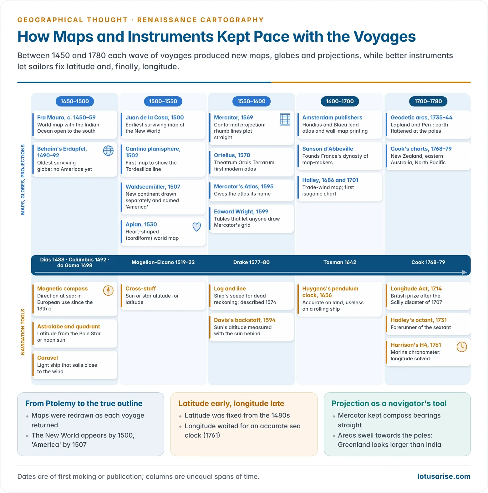
- Direction: the magnetic compass, used in Europe from the 12th–13th centuries.
- Latitude from the height of the Pole Star or the noon sun:
- the mariner’s astrolabe and quadrant, then the cross-staff (16th century);
- John Davis’s backstaff (1594), used with the sun behind the observer;
- John Hadley’s octant (1731), the forerunner of the sextant.
- Speed and distance: the log and line (16th century), the basis of dead reckoning.
- Longitude was the great unsolved problem, because it needs accurate time at sea.
- Christiaan Huygens’s pendulum clock (1656) failed on a rolling ship.
- After the Scilly naval disaster (1707), Britain’s Longitude Act (1714) offered a prize.
- John Harrison’s marine chronometer H4 kept time within seconds on trials to Jamaica (1761) and Barbados (1764). Parliament paid him a final £8,750 in 1773.
- From then on, navigators could fix longitude as reliably as latitude.
The Portuguese Route Round Africa
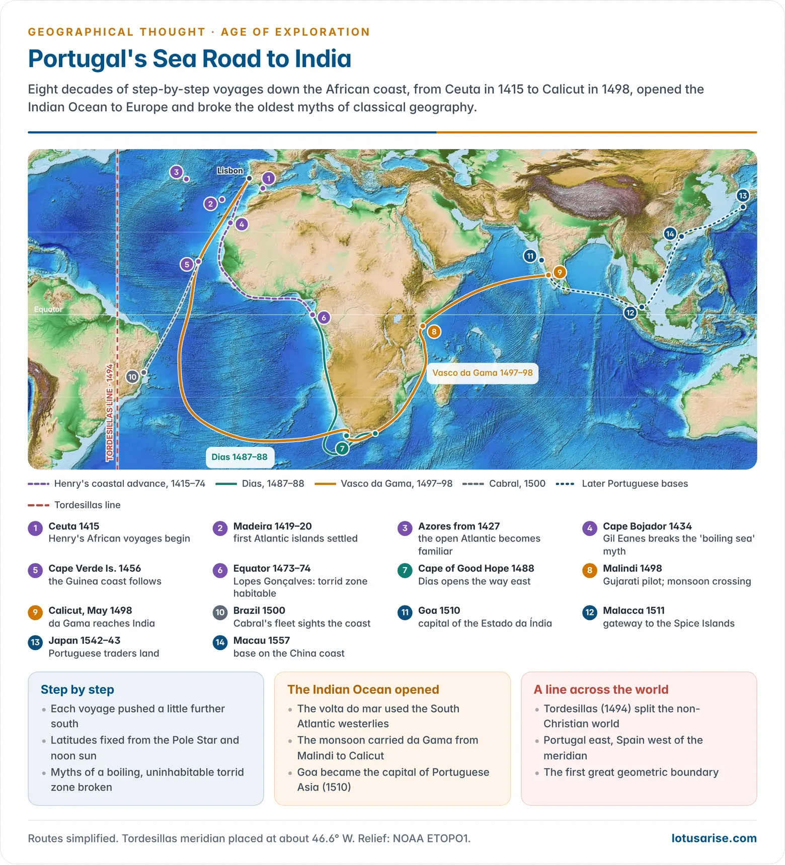
- Prince Henry the Navigator (1394–1460) began the systematic exploration of the African coast after Portugal captured Ceuta (1415).
- He gathered pilots, chart-makers and astronomers of many faiths at Sagres, near Cape St Vincent, with the Majorcan cartographer Jácome. Later writers called it a “school of navigation”; historians now doubt that a formal school existed.
- His captains reached Madeira (1419–20) and the Azores (from 1427), turning the high Atlantic into familiar water.
- Cape Bojador (1434): Gil Eanes rounded the cape that sailors feared. Legend said the sea boiled beyond it and men turned black. His safe return broke the myth of an impassable torrid zone.
- Step by step south:
- Cape Blanc and the Mauritanian coast (1441);
- the Cape Verde Islands and the Guinea coast (1450s);
- the equator, crossed by Lopes Gonçalves in 1473 or 1474, disproving the Greek idea that the torrid zone was uninhabitable.
- Bartolomeu Dias (c. 1450–1500), blown south by storms, rounded the southern tip of Africa in 1488 and named the Cape of Good Hope on his return. The sea route to the Indian Ocean was open.
- Vasco da Gama (c. 1469–1524) sailed from Lisbon in 1497.
- He swung far out into the South Atlantic (the volta do mar), using the westerlies, and stayed some three months out of sight of land.
- At Malindi he engaged a local pilot, probably a Gujarati, who used the south-west monsoon to cross the Arabian Sea. He reached Calicut in May 1498.
- The voyage ended the Venetian–Arab monopoly of the spice route. Only about a third of his men survived, mostly lost to scurvy.
- The Estado da Índia: Pedro Álvares Cabral’s fleet to India sighted Brazil (1500). Goa (1510) became the capital of Portuguese Asia, followed by Malacca (1511), Japan (1542–43) and Macau (1557).
Columbus and the Spanish Voyages
- Christopher Columbus (1451–1506), a Genoese navigator living in Lisbon, proposed reaching Asia by sailing west.
- From Ptolemy, d’Ailly and Marco Polo he took an underestimate of the earth’s size and an overestimate of Asia’s length, so he placed Japan roughly where the Americas lie.
- Backed by Ferdinand and Isabella of Spain, he sailed from Palos on 3 August 1492 with the Santa María, Pinta and Niña. He made landfall in the Bahamas (San Salvador) on 12 October 1492, then reached Cuba and Hispaniola.
- He made four voyages (1492–1504) to the Caribbean, Trinidad, the Orinoco mouth and the coast of Central America. He died believing he had reached the Indies, hence “West Indies” and “Indians”.
- His real discovery was the Atlantic wind system: out with the north-east trades, home with the westerlies.
- Treaty of Tordesillas (1494): Spain and Portugal divided the non-Christian world along a meridian 370 leagues west of the Cape Verde Islands.
- Portugal took lands east of the line (Africa, the Indian Ocean and, as it proved, Brazil). Spain took lands to the west.
- It was the first great geometric boundary, the principle later used to partition Africa.
- Others completed the outline:
- John Cabot, sailing for England, reached Newfoundland (1497).
- Amerigo Vespucci sailed along South America (1499–1502) and argued that it was a “New World”, not Asia.
- Juan Ponce de León reached Florida (1513). His pilot Antón de Alaminos noted the Gulf Stream.
- Vasco Núñez de Balboa crossed Panama and sighted the Pacific (1513).
The Magellan–Elcano Circumnavigation (1519–1522)
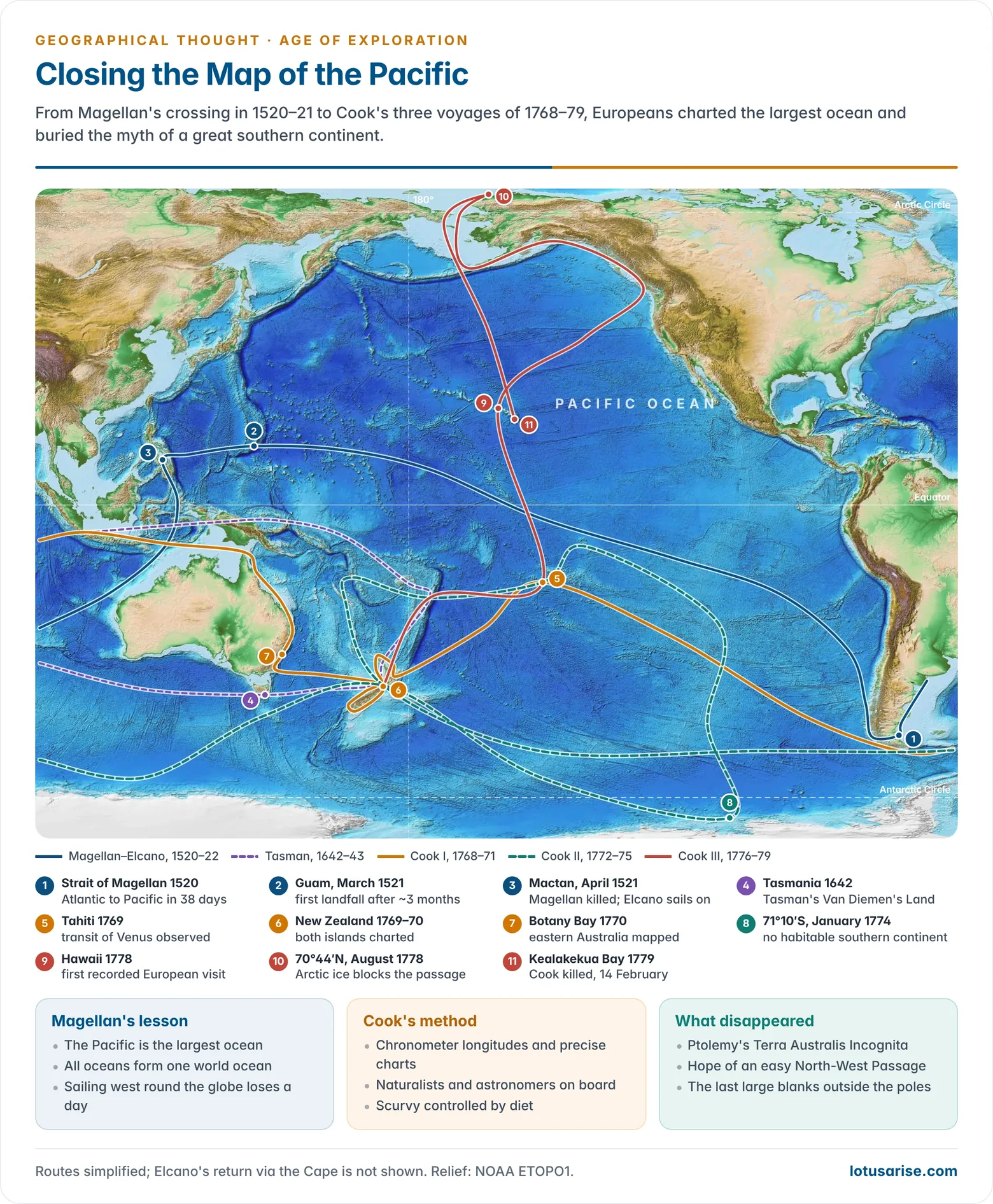
- Ferdinand Magellan (c. 1480–1521), a Portuguese captain in Spanish service, sought a western route to the Spice Islands (Moluccas). He sailed from Spain in September 1519 with five ships and about 270 men.
- The route:
- He wintered in Patagonia and crushed a mutiny.
- He passed the strait now named after him (October–November 1520) and entered the ocean he called the Pacific.
- The crew spent about three months crossing it with no landfall but tiny islands, eating leather and sawdust and dying of scurvy, before reaching Guam and then the Philippines (March 1521).
- Magellan was killed at Mactan on 27 April 1521. Juan Sebastián Elcano brought the Victoria, with 18 survivors, back to Spain in September 1522.
- What it proved:
- The earth was far larger than Ptolemy and Columbus had thought, and the Pacific was the largest ocean.
- All the oceans formed one connected world ocean.
- The survivors found their log was one day behind the calendar ashore. It was the first practical lesson that travelling round the globe westward loses a day, the idea behind the later International Date Line.
The Dutch, the English and the Southern Continent
- In the 17th century the Dutch and English East India Companies (1602 and 1600) took the lead. They also searched for northern passages to Asia.
- Willem Barentsz explored the Arctic (1594–97) and died on Novaya Zemlya. The Barents Sea is named after him.
- Willem Janszoon made the first recorded European landing in Australia, on Cape York (1606).
- Abel Tasman reached Tasmania and New Zealand (1642).
- William Dampier described the coast of New Holland (1688, 1699).
- Ptolemy’s great southern land (Terra Australis Incognita) still filled the southern oceans on most maps.
James Cook and the End of the Age of Exploration
- James Cook (1728–1779), a Royal Navy surveyor trained on the St Lawrence and Newfoundland coasts, made three Pacific voyages that closed the age.
- First voyage (1768–71, Endeavour): observed the transit of Venus at Tahiti (1769), charted both islands of New Zealand, and mapped eastern Australia (1770), including Botany Bay and the Great Barrier Reef.
- Second voyage (1772–75, Resolution and Adventure): crossed the Antarctic Circle (1773), the first recorded crossing, and reached 71°10′S (1774). He showed that no habitable southern continent existed, though he suspected ice-bound land beyond.
- Third voyage (1776–79): searched for a North-West Passage from the Pacific, reached Hawaii (1778) and passed through the Bering Strait to the ice at about 70°44′N. He was killed at Kealakekua Bay, Hawaii, on 14 February 1779.
- Scientific travel: Cook carried astronomers and naturalists, among them Joseph Banks and the botanists Johann Reinhold and Georg Forster.
- Georg Forster’s comparative observations later drew Alexander von Humboldt to geography.
- Cook’s control of scurvy won the Royal Society’s Copley Medal (1776).
- By Cook’s death the outline of the inhabited continents was essentially complete. The polar interiors remained. The South Pole was reached only in 1911 (Roald Amundsen), and Antarctic exploration became a 20th-century scientific enterprise.
| Explorer | Dates | Sailed for | Main achievement |
|---|---|---|---|
| Prince Henry the Navigator | 1394–1460 | Portugal | Patron of the African voyages; Madeira, Azores |
| Bartolomeu Dias | c. 1450–1500 | Portugal | Rounded the Cape of Good Hope (1488) |
| Christopher Columbus | 1451–1506 | Spain | Caribbean landfall (1492); four voyages |
| John Cabot | c. 1450–c. 1500 | England | Newfoundland (1497) |
| Vasco da Gama | c. 1469–1524 | Portugal | Sea route to India, Calicut (1498) |
| Pedro Álvares Cabral | c. 1467–c. 1520 | Portugal | Brazil (1500) |
| Amerigo Vespucci | 1454–1512 | Spain, Portugal | South America seen as a “New World” |
| Juan Ponce de León | 1474–1521 | Spain | Florida (1513); Gulf Stream noted |
| Ferdinand Magellan | c. 1480–1521 | Spain | First circumnavigation, completed by Elcano (1522) |
| Willem Barentsz | c. 1550–1597 | Netherlands | Arctic seas; Novaya Zemlya |
| Willem Janszoon | c. 1570–1630 | Netherlands | First recorded landing in Australia (1606) |
| Abel Tasman | 1603–1659 | Netherlands | Tasmania, New Zealand (1642) |
| James Cook | 1728–1779 | Britain | Pacific charted; southern continent disproved |
Cartography and the New World Picture
Maps and Globes
- Venice and Genoa were the first centres of the new cartography, as the ports from which Europeans sailed to the eastern Mediterranean.
- Fra Mauro’s world map (Venice, c. 1450, with a copy for Portugal completed in 1459) showed the Indian Ocean open to the south, breaking with Ptolemy’s enclosed sea. Arab sailors already knew this.
- Martin Behaim’s Erdapfel (“earth apple”, Nuremberg, 1490–92) is the oldest surviving terrestrial globe.
- It was painted by Georg Glockendon and built on Ptolemy’s small earth.
- It shows open ocean between Europe and Asia, since the Americas were still unknown.
- Juan de la Cosa’s chart (1500) combined Columbus’s first three voyages and Cabot’s voyage. It is the earliest surviving map to show the New World.
- The Cantino planisphere (1502), smuggled out of Lisbon, recorded Portuguese knowledge of Africa, Brazil and da Gama’s route to India. It is the first map to show the Tordesillas line.
- Martin Waldseemüller’s world map (Universalis Cosmographia, 1507) showed the new lands as a separate continent and named it “America” after Vespucci.
- His later Carta Marina (1516) is a separate map, and it dropped the name.
The Problem of Projection
- On a flat chart, a straight line drawn over a long distance did not lead to the expected port. A projection was needed that kept direction true.
- Peter Apian’s heart-shaped (cordiform) world map (1530) curved both parallels and meridians, but it distorted both distance and direction.
- His successor Gerardus Mercator (Gerhard Kremer) drew a double-cordiform world map in 1538.
- Mercator’s projection (1569) was a cylindrical, conformal projection with parallels spaced further apart towards the poles.
- Its key property is that a line of constant compass bearing (rhumb line or loxodrome) plots as a straight line, so a navigator can lay a course with a ruler.
- It does not show the shortest (great-circle) route as a straight line.
- It exaggerates areas in high latitudes: Greenland appears larger than India although it is about two-thirds of India’s area.
- Edward Wright’s Certaine Errors in Navigation (1599) published the tables of meridional parts that let others construct the projection. Mercator had not explained his method.
Atlases and the Publishing Revolution
- Abraham Ortelius of Antwerp published Theatrum Orbis Terrarum (1570), the first modern atlas of uniform, bound maps.
- Mercator’s Atlas (1595) gave such books their name.
- Amsterdam (the Hondius and Blaeu firms) dominated atlas and wall-map publishing in the 17th century.
- In France, Nicolas Sanson d’Abbeville (1600–1667) founded a dynasty of cartographers that produced maps and atlases for over a century.
Cosmography, Chorography and the Travel Collections
- Renaissance scholars seldom called themselves geographers. They wrote cosmography, the description of the earth and its place in the universe, in the tradition of Strabo and Ptolemy.
- Chorography described regions. Topography described particular places on a small scale. The voyages supplied raw material for both.
| Term | Scale | Scope | Example |
|---|---|---|---|
| Cosmography | Universe and globe | Astronomy, maps, peoples, nature | Münster, Cosmographia (1544) |
| Chorography | Countries and regions | Regional description | Accounts of newly found lands |
| Topography | Particular places | Local detail, place names, lore | Town and county descriptions |
- Sebastian Münster’s Cosmographia (1544) mixed fresh data with fables, such as headless men, and went through dozens of editions. It earned him the title of the “German Strabo”.
- Philipp Clüver (Cluverius) wrote a better-informed universal geography, Introductio in universam geographiam (1624).
- Nathanael Carpenter’s Geography Delineated Forth in Two Bookes (Oxford, 1625) was the first major geography in English.
- Travel collections spread the new knowledge:
- Giovanni Battista Ramusio’s Navigationi et Viaggi (1550–59);
- Richard Hakluyt’s Principall Navigations (1589; enlarged in three volumes, 1598–1600);
- the illustrated voyages published by Theodor de Bry and his heirs at Frankfurt (1590–1634).
Impact on Geographical Thought
The Scientific Revolution
- The voyages coincided with a revolution in ideas about the universe, and each reinforced the other.
- Nicolaus Copernicus (1473–1543), in De revolutionibus orbium coelestium (1543), put the sun at the centre.
- Johannes Kepler (1571–1630) showed that planets move in elliptical orbits, with his first two laws in 1609 and the third in 1619.
- Galileo Galilei (1564–1642) turned the telescope on the sky (1609–10) and argued for an ordered universe described by mathematical laws.
- Isaac Newton’s Principia (1687) gave the law of universal gravitation.
- The shape of the earth: Newton and Huygens predicted an earth flattened at the poles. French geodetic expeditions to Lapland (1736–37) and Peru (1735–44) measured meridian arcs and confirmed it, settling the dispute with the Cassini school.
- The result was a shift from the geocentric, scriptural world view to a heliocentric, law-governed one. The new branches of science that followed broke up the old universal scholarship.
Effects on Geography
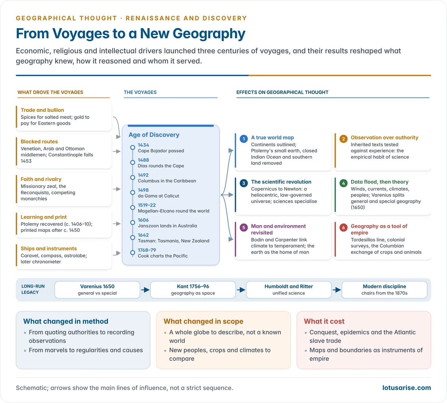
- A true world map: the continents and oceans took their real shape.
- Ptolemy’s errors were corrected one by one: the small earth, the land-locked Indian Ocean, the uninhabitable torrid zone and the southern continent.
- Experience over authority: observed fact overturned inherited text. This empirical habit is the root of modern scientific geography.
- A flood of data: new information on winds, currents, tides, climates, plants, animals and peoples.
- Edmond Halley drew the first map of the trade winds and monsoons (1686) and the first chart of magnetic variation, with isogonic lines (1701).
- The scale of this data forced the question of how particular facts relate to general principles.
- From cosmography to general geography: the answer came in Bernhard Varenius’s Geographia Generalis (1650).
- He split the field into general geography (laws of the whole earth) and special geography (description of particular regions).
- This is the seed of the later systematic–regional dualism.
- New questions about the earth: with theology loosening its grip, scholars began to treat the earth as a product of natural processes over long time.
- Examples include William Whiston’s comet theory (1696) and, later, James Hutton’s uniformitarianism.
- Carl Linnaeus’s classification of plants and animals reflected the same ordering impulse.
- Man and environment: contact with distant peoples revived the classical idea of climatic influence.
- Jean Bodin (1566) and Nathanael Carpenter (1625) linked temperament and government to climatic zones, an early form of environmental determinism.
- The earth was widely described as the home of man, made for human use, a teleological idea that Carl Ritter later developed.
- Comparison and relativism: observing many societies slowly encouraged comparative study of cultures, though usually through a European and Christian lens.
- The Columbian exchange: maize, potato, cassava, chilli and tobacco crossed the Atlantic. Wheat, sugar cane, cattle and horses went the other way. This reshaped world agriculture and diets.
- India gained the chilli, potato and tomato.
- Geography as a tool of empire: maps, surveys and boundaries became instruments of colonial expansion. The Tordesillas line was the first sign of this. Later critical geographers stressed the link.
Evaluation
- “Discovery” is a European word. The lands were inhabited, and the voyages relied on indigenous and Asian knowledge: the Gujarati pilot at Malindi, Polynesian wayfinders such as Tupaia on Cook’s Endeavour, and Arab knowledge of the monsoon.
- Costs: conquest, epidemics that devastated the Americas, the Atlantic slave trade and the plunder of colonial economies. These belong to the same history as the maps.
- Lasting gains for the discipline:
- the complete world map;
- mathematical cartography and the solution of longitude;
- the shift from description of the marvellous to the search for regularities;
- the first statement of geography’s general–special structure.
- These led on to the classical geography of Humboldt and Ritter and the modern discipline.
Previous Year Questions
- No direct PYQ has been asked on this sub-topic yet.
 History Optional PYQ Master Pack: Topic-wise Model Answers (1985–2025) by LotusArise IAS
 History Optional Mains Master Kit 2027 Complete Self-Study System — Notes, Mapping & Premium Articles by LotusArise IAS