

- Population geography emerged as a distinct sub-discipline in India in the late 1950s, although census reports and geographers had described the distribution and density of India’s people long before.
- Its growth reflects:
- a move from general human geography to specialised spatial analysis of population;
- a strong American influence, carried by Indian geographers trained under Glenn Trewartha at Wisconsin;
- a base in universities and the Census of India, rather than in any independent theoretical school.
- Its themes have followed India’s own population growth and policy concerns: regional growth, migration, literacy, urbanisation, sex ratio, tribes, and now ageing and health.
Origins

Before the 1950s
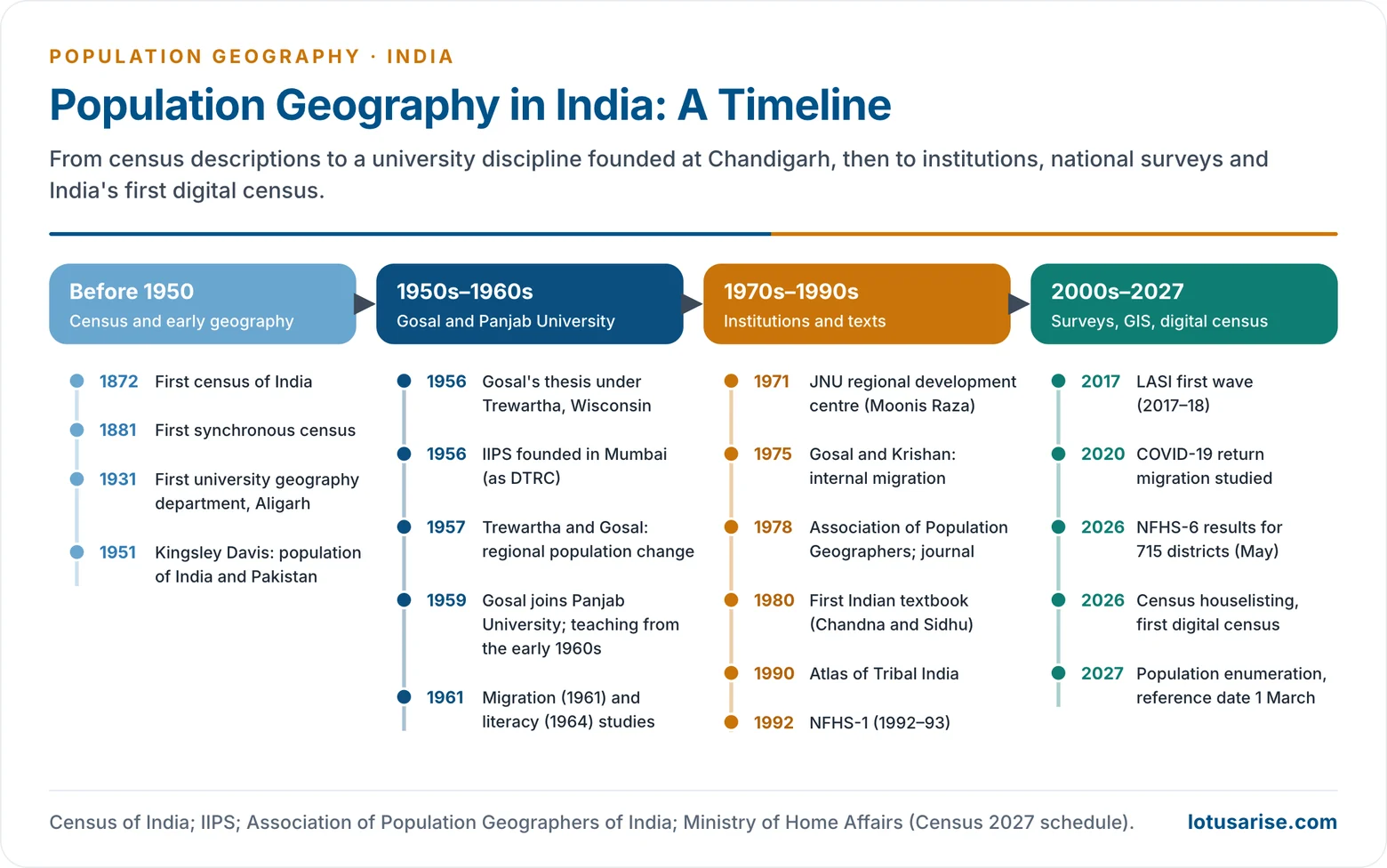
- The Census of India (first count 1872, first synchronous count 1881) and the district gazetteers recorded distribution, density, caste, religion and language. Their reports carried the first descriptive population geography of the country.
- Geography itself came late to Indian universities.
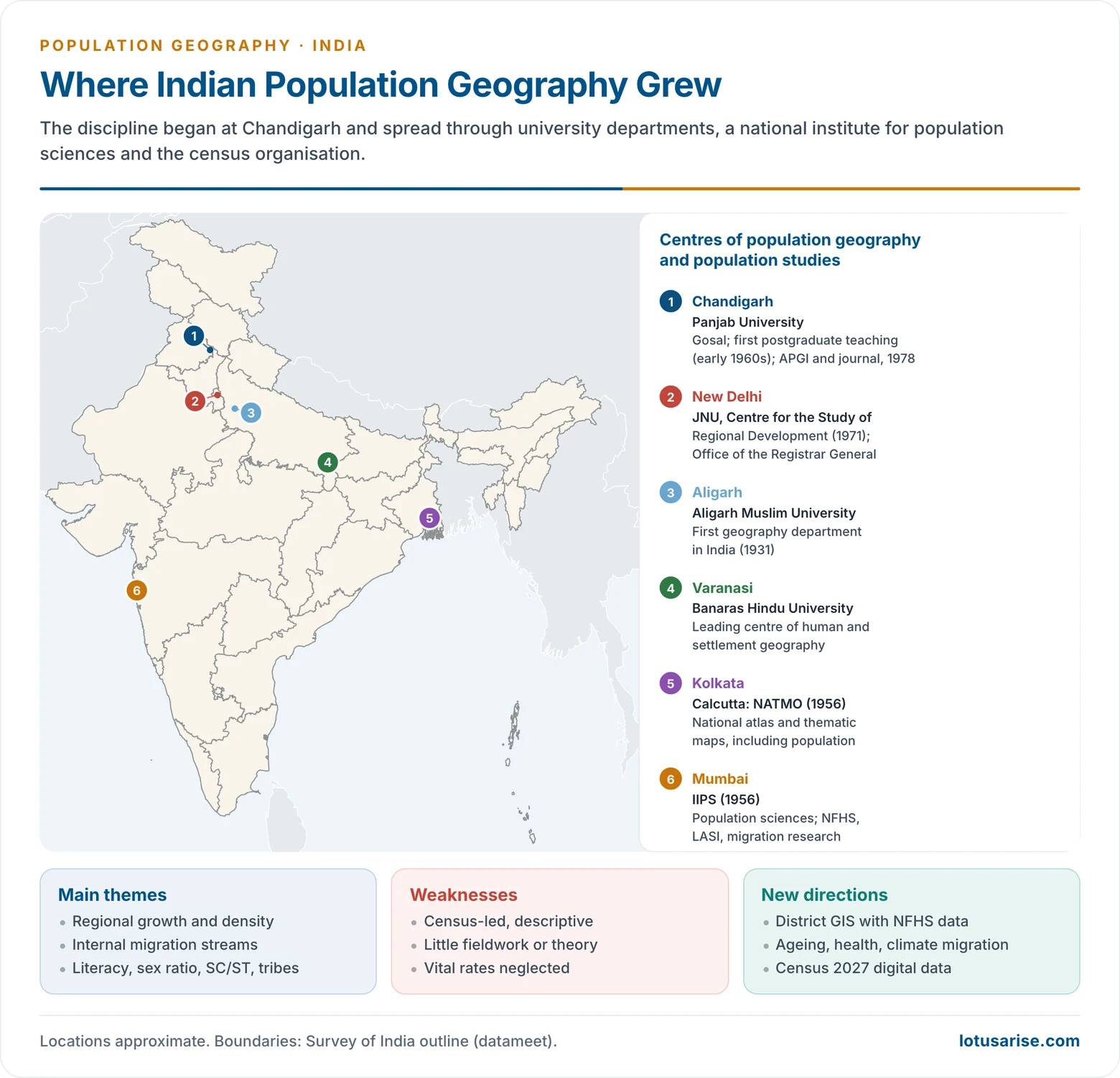
- The first department of geography was set up at Aligarh Muslim University in 1931.
- At Independence only a handful of universities, mostly in the Ganga plain, taught the subject.
- Early geographical writing on population was regional and descriptive: density maps, district accounts, man–land ratios.
- The demographer Kingsley Davis, in The Population of India and Pakistan (1951), gave the first full modern analysis of the subcontinent’s population.
Gurdev Singh Gosal and Panjab University
- Gurdev Singh Gosal (born 1927) is regarded as the founder of population geography in India.
- He took his master’s degree at Punjab University, Lahore, and his doctorate at the University of Wisconsin under Glenn Trewartha.
- His thesis, “A Geographical Analysis of India’s Population” (1956), was the first systematic geographical analysis of India’s population. It mapped spatial patterns and regional demographic differences.
- With Trewartha he wrote “The Regionalism of Population Change in India” (1957). It used India’s seven decennial censuses to read changes in numbers and characteristics through time and space.
- He joined Panjab University, Chandigarh, in 1959 and began teaching and research in population geography there in the early 1960s.
- Panjab University became the first university to teach population geography at the postgraduate level.
- His colleagues extended his framework to village- and town-level data.
- His major papers set the agenda for the next generation:
- internal migration: “Internal Migration in India: A Regional Analysis” (1961);
- literacy: “Literacy in India: An Interpretative Study” (1964);
- migration streams, with Gopal Krishan: “Patterns of Internal Migration in India” (1975), in the international volume People on the Move.
- In 1978 he founded the Association of Population Geographers of India (APGI) and its journal Population Geography, both based at Panjab University.
Institutional Growth and Themes
Spread of Teaching
- From Panjab University the subject spread to graduate and postgraduate courses across the country from the 1960s and 1970s. This marks the institutionalisation of the field.
- Two-thirds of India’s university geography departments were founded between 1950 and 1970, which helped the spread.
- Other early centres of human geography included Banaras Hindu University (noted for settlement studies) and Kolkata, where the National Atlas Organisation (now NATMO) was set up in 1956 to prepare national and thematic atlases, population maps among them.
- The Centre for the Study of Regional Development (CSRD), Jawaharlal Nehru University, founded in 1971 under Moonis Raza, joined geography, economics and population studies in one programme.
- Demographers and census experts such as Asok Mitra (Census Commissioner for the 1961 Census) and Mahendra K. Premi worked there.
- It gave Indian population geography a social and regional-development orientation.
Population Studies Institutions
- International Institute for Population Sciences (IIPS), Mumbai:
- Founded in 1956 as the Demographic Training and Research Centre, with the Sir Dorabji Tata Trust, the Government of India and the United Nations as sponsors.
- It took its present name and became a deemed university in 1985.
- It is the nodal agency for the National Family Health Survey and the Longitudinal Ageing Study in India, and runs a South Asia centre on labour mobility and migrants.
- The Census of India (Office of the Registrar General) and the Sample Registration System remain the field’s main data providers.
- A network of Population Research Centres in universities, set up under the health ministry, carries out state-level studies and helps run national surveys.
Textbooks
- R. C. Chandna and M. S. Sidhu, both of Panjab University, wrote the first Indian textbook, An Introduction to Population Geography (1980).
- Chandna’s later Geography of Population became a standard Indian text. M. I. Hassan‘s Population Geography (2005) and others followed.
Major Themes and Contributors
| Theme | Representative work |
|---|---|
| Regional pattern of growth | Trewartha and Gosal (1957); Gosal on recent population growth (1982) |
| Internal migration | Gosal (1961); Gosal and Krishan (1975); Ashish Bose, Migration Streams in India (1967) |
| Literacy | Gosal (1964) |
| Urbanisation | Ashish Bose; Gopal Krishan; Amitabh Kundu; R. B. Bhagat |
| Tribal population | Moonis Raza and Aijazuddin Ahmad, An Atlas of Tribal India (1990) |
| Regional demographic disparity | Ashish Bose’s “BIMARU” states (1980s) |
| Health and disease | Rais Akhtar (medical geography) |
| Gender | Saraswati Raju (gender and space) |
- Regional growth and distribution: the classic theme. Studies divided India into regions of fast and slow growth and explained them by irrigation, colonisation of new land, migration and mortality decline.
- Migration: census migration tables made it the most studied process.
- Streams were mapped by distance (intra-district, inter-district, inter-state) and by rural–urban direction.
- Marriage migration of women and the eastward–westward labour streams were identified.
- Migration in India remains the busiest field of research.
- Regional disparity: Ashish Bose coined “BIMARU” in the 1980s for Bihar, Madhya Pradesh, Rajasthan and Uttar Pradesh. The term fixed the idea of a high-fertility, low-development demographic core in the Hindi belt.
- Composition: literacy, sex ratio, work participation, and the distribution of Scheduled Castes and Scheduled Tribes, studied state by state and district by district from census tables.
Character and Evaluation
Methodological Character
Empirical and Descriptive
- Indian population geography has been largely empirical and descriptive. Its main thrust is “from facts to theory“.
- Its aim has been to map population patterns and regional disparities.
- Theory building, demographic techniques and model building received little attention.
- This is a limited, data-driven positivism: quantitative, but rarely model-based.
Census-centred
- The Census of India is the field’s backbone.
- Strength: large, reliable data down to village level, comparable over many decades.
- Limits:
- Research topics have tended to follow what the census tabulates.
- The ease of secondary data bred complacency about primary fieldwork.
- Analysis is often static: cross-sections ten years apart.
Weak Fieldwork and Vital Events
- The fieldwork tradition in population geography has been weak, so micro-level behaviour and the cultural roots of fertility and migration are poorly understood.
- Births and deaths received less attention than distribution or migration, for two reasons:
- Data: the Civil Registration System is incomplete at district level, and the more reliable SRS gives rates only for states, while India’s diversity within states is often greater than between them.
- Skills: geographers had little training in the demographic techniques that estimate vital rates from census age data.
Critical Evaluation
- Limited theory: the field has engaged little with structuralism, humanism and post-modern approaches. Conceptual innovation and interdisciplinary integration have lagged behind the West.
- Pattern over process: most studies ask where people are, not why and how fertility, mortality and migration work. Fertility behaviour, migration decisions and socio-cultural determinants remain under-studied.
- Incomplete coverage: Gosal himself judged the discipline’s achievements incomplete in spatial spread and in content.
- Strengths: a large body of regional and district-level mapping, strong cartographic skills, and close links with the census. These have made Indian population geography useful for planning.
Recent Directions and Future Needs
Recent Directions
- District-level spatial analysis with GIS:
- NFHS district fact sheets (NFHS-5 in 2019–21; NFHS-6, 2023–24, covering 715 districts) allow mapping of fertility, nutrition and health at district level.
- Spatial statistics expose clusters such as the north-western belt of low child sex ratio and the central and eastern belt of high fertility.
- Migration studies:
- Census 2011 migration tables and the Periodic Labour Force Survey (2020–21) are the main sources.
- The return of migrant workers during the 2020 COVID-19 lockdown revealed the scale of circular migration and spurred new work on informal labour mobility.
- Ageing: the Longitudinal Ageing Study in India (first wave 2017–18) opened research on the regional geography of ageing, with Kerala, Tamil Nadu and Himachal Pradesh among the oldest states.
- Gender and social geography: women’s work, sex ratio at birth, caste and tribal deprivation.
- Health geography: disease mapping, access to health facilities and the double burden of disease.
- Population and environment: climate-induced migration, disaster vulnerability and urban flood risk.
- New data: Census 2027, India’s first digital census, uses satellite imagery to delineate houselisting blocks and will collect caste data for the first time since 1931. It will give geographers geo-referenced data at a finer scale than ever before.
Future Needs
- Theory and method: combine demographic theory, spatial models and interdisciplinary approaches, moving from descriptive to analytical and explanatory work.
- Primary fieldwork and qualitative methods to understand behaviour behind the numbers.
- Training in demographic techniques, GIS and spatial statistics.
- Policy relevance: urban planning, migration management, resource allocation, regional development and population policy.
Previous Year Questions
- No direct PYQ has been asked on this sub-topic yet.




