

- A mountain pass is a navigable route through a mountain range or over a ridge. It serves as a gateway between parts of the country and between India and its neighbours. Passes across the mountain chains have shaped trade, war, pilgrimage and the migration of people and animals throughout history.
- India’s passes fall into three sets: the high Himalayan and Karakoram passes, the lower passes and gaps of the Peninsula, and the north-western gateways that now lie in Pakistan.
- Local names show their setting: La is Tibetan for pass, ghat is used in the Western Ghats and the Aravalli, and gap marks a wide break in a range.
Meaning and Importance
What a Pass Is
- At lower elevations, a pass may be called a hill pass.
- Passes often lie just above the source of a river, and so form a drainage divide.
- The Chenab starts near Bara Lacha La, and the Beas and Ravi near Rohtang.
- Mariam La parts the source of the Brahmaputra from the Manasarovar basin.
- The Satluj works the other way, as an antecedent river, also spelt Sutlej, that enters India near Shipki La.
- Form varies. A pass may be very short, with steep slopes up to its top, or a valley many kilometres long, whose highest point can be identified only by surveying.
- The Greater Himalaya is the hardest barrier. Its passes are generally above 4,570 m and snowbound for most of the year.
- Height alone does not rule a route. Rainfall, landslides, avalanches, dense forest and the political line can each close it.

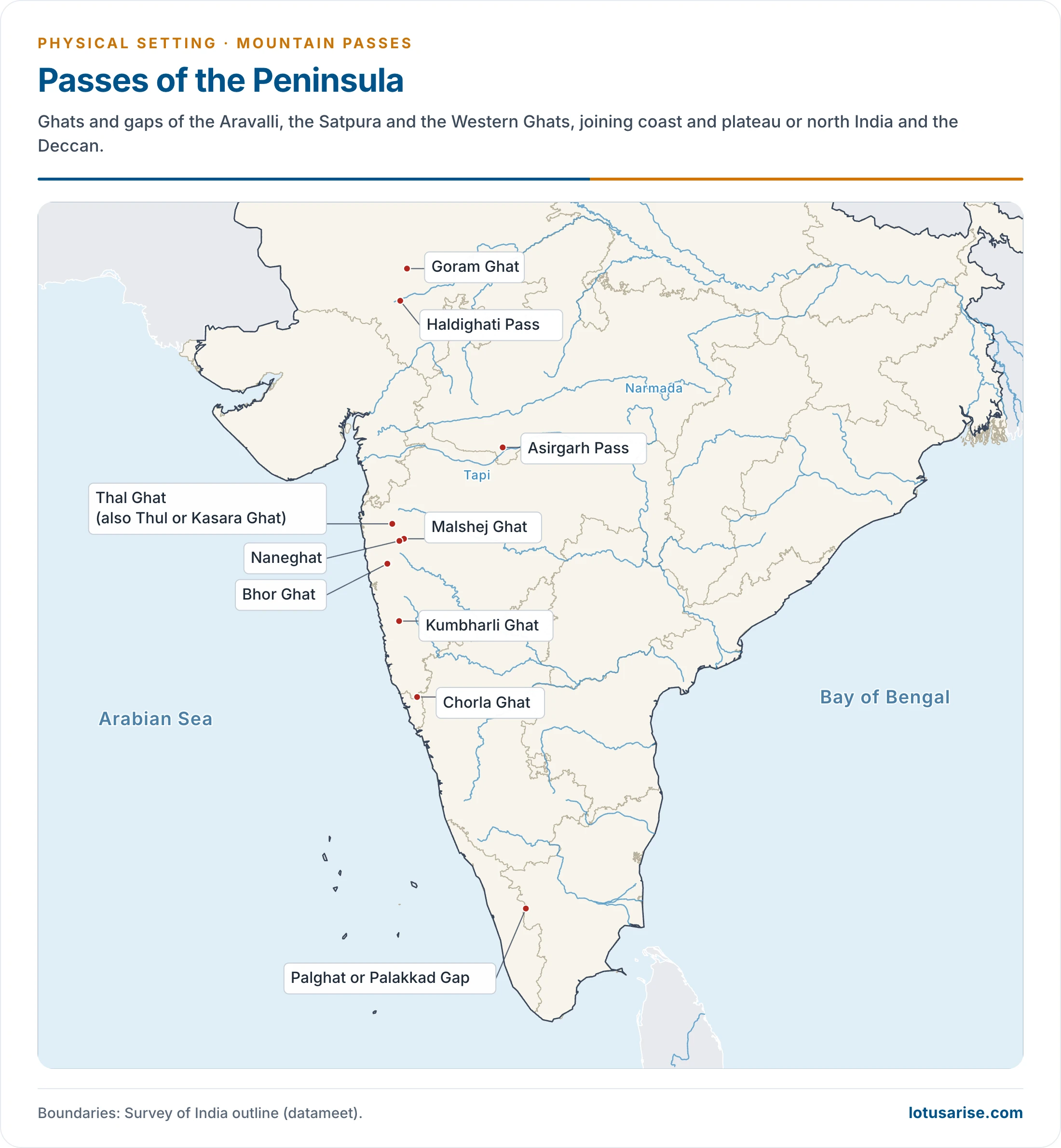
- On this map, read Asirgarh for “Asirgrah”.
Routes into India
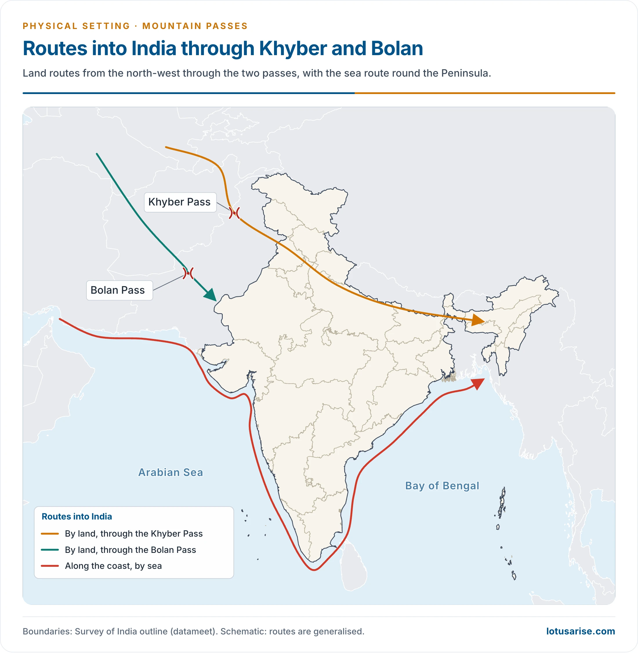
- The northern mountain wall isolates India without sealing it. Settlers, invaders, traders and pilgrims crossed it in every age, and Indian commerce and culture went out by the same routes.
- North: three very high passes, Muztagh, Karakoram and Changchemo, gave little scope for movement, being given as over 6,000 m in older accounts. The Karakoram Pass is now put at 5,540 m.
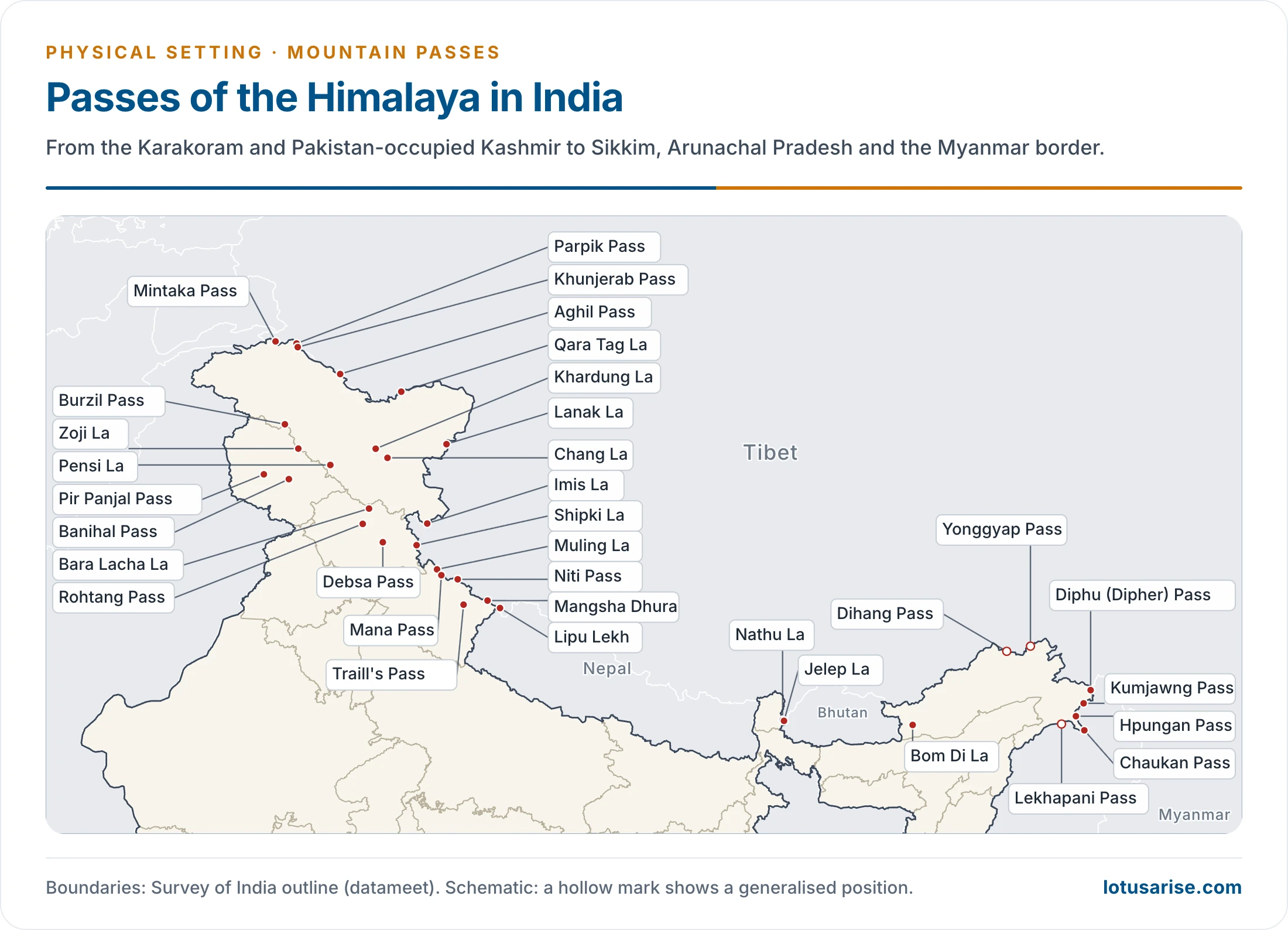
- Across the main range: Burzil and Zoji La in the Kashmir section; Bara Lacha La and Shipki La in Himachal Pradesh; Thaga La, Niti and Lipu Lekh in Uttarakhand; Nathu La and Jelep La in Sikkim.
- North-west: the Hindukush is pierced by many passes that are snow-covered in winter but open in other seasons.
- Khyber, Malakand, Tochi, Gomal and Kohat led from Afghanistan to the subcontinent.
- The roads from Herat and Seistan meet at Quetta, above the Bolan Pass.
- Greeks, Huns, Turks and Mughals came mainly by these routes, which is why the north-west shaped so much of India’s political history.
- North-east: hills on the Myanmar border are low, rarely above 3,000 m, yet dense forest, heavy rain and swift rivers made them an effective barrier. Few outsiders crossed here.
- The Moreh–Tamu road link between Manipur and Myanmar opened in 1995.
- Pangsau Pass carried the Ledo (Stilwell) Road into Burma during the Second World War.
Passes of the Himalaya
Jammu and Kashmir
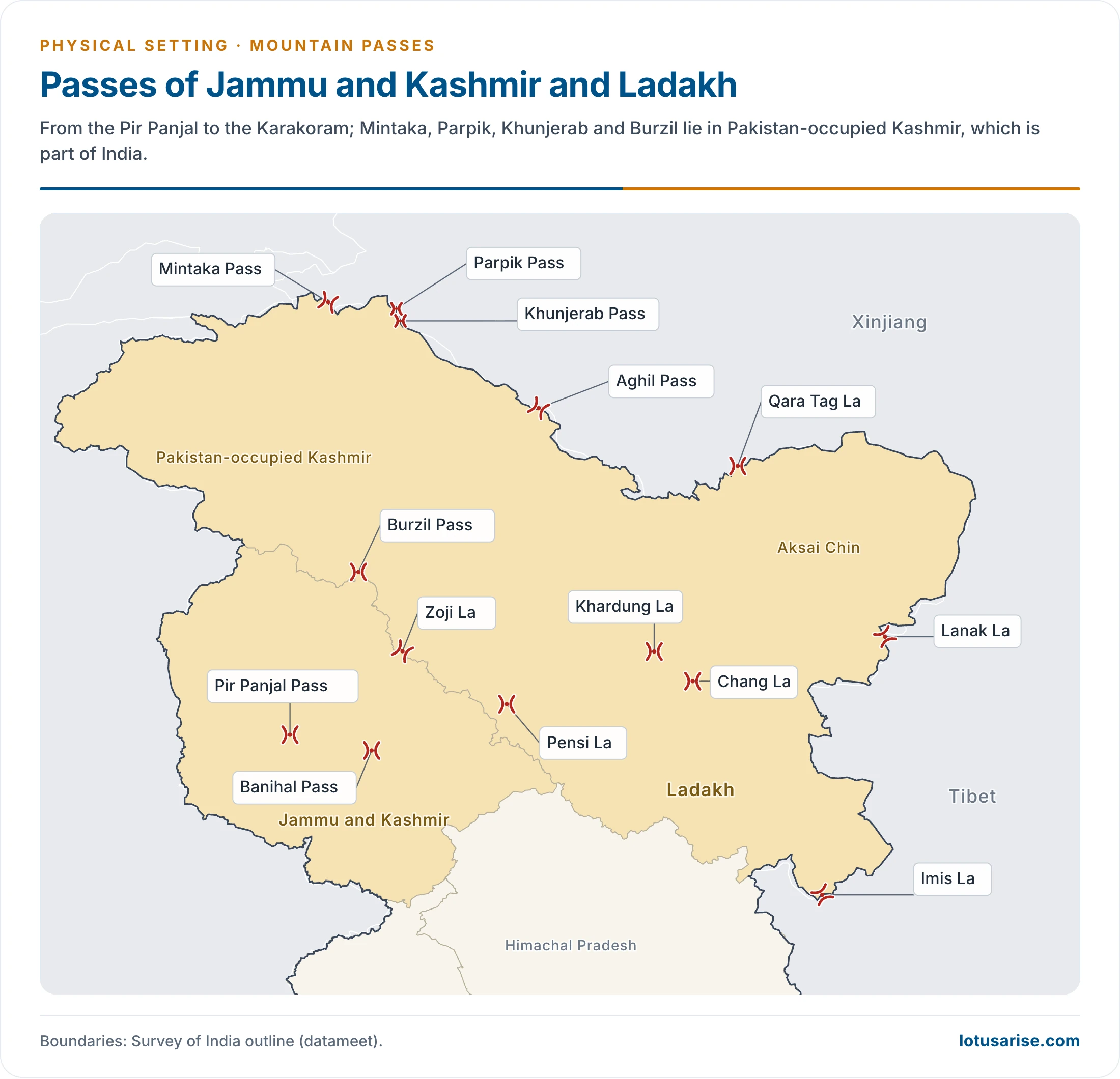
- Banihal Pass (2,832 m, 9,291 ft): crosses the Pir Panjal Range and joins the Kashmir Valley with the outer Himalaya and the plains to the south.
- In Kashmiri, Banihal means “blizzard”. It is snow-covered in winter.
- Jawahar Tunnel (about 2.85 km), opened in December 1956, took the Jammu–Srinagar road under the pass.
- The Banihal–Qazigund road tunnel (8.45 km) opened to traffic on trial in August 2021.
- An 11 km rail tunnel between Banihal and Qazigund opened in 2013. The Udhampur–Srinagar–Baramulla line was commissioned in June 2025.
- Zoji La (about 3,528 m, 11,578 ft): links Srinagar with Kargil and Leh on National Highway 1 (formerly NH-1D). Higher figures of 3,850 m and 12,400 ft appear in older accounts.
- It lies on the boundary of Ganderbal district (Jammu and Kashmir) and Kargil district (Ladakh), and is commonly placed at the western end of the Zaskar Range.
- It is a water parting: the Sind runs west to the Jhelum, and the Dras runs east towards the Suru and the Indus.
- The Beacon Force of the Border Roads Organisation (BRO) clears and maintains the road. Snow has usually closed it from about December to mid-May.
- Pir Panjal Pass (about 3,480 m), or Peer Ki Gali: the traditional crossing from Jammu to Srinagar on the Mughal Road, and the shortest road access from Jammu to the Valley.
- It was closed after the Partition. The Mughal Road, joining Rajouri and Poonch with Shopian, now carries traffic again in the open season.
Ladakh
- Khardung La (5,359 m, 17,582 ft): on the Ladakh Range, about 40 km north of Leh. It joins the Indus and Shyok valleys, and leads on to the Nubra valley and the Siachen Glacier.
- BRO built the road in 1976. It is closed in winter.
- It was long advertised at 5,602 m (18,380 ft) as the world’s highest motorable road.
- Taglang La, Tanglang La or Thang La (5,328 m, 17,480 ft): on the Leh–Manali Highway. Once called the second-highest motorable pass in India, it has been passed by newer high roads.
- Umling La (19,024 ft, 5,799 m): in eastern Ladakh near Demchok. Its road entered Guinness World Records in November 2021 as the highest motorable road.
- Mig La (about 19,400 ft): BRO completed the 64 km Likaru–Mig La–Fukche road in October 2025, going higher still.
- Chang La (5,360 m, 17,585 ft): on the Leh–Pangong Lake road, between Leh and the Shyok valley in the Changthang side of Ladakh. It stays within Ladakh.
- The road beyond it is very steep, and it is closed in winter. A temple to Chang La Baba stands at the top.
- Lanak La (5,466 m, 17,933 ft): India’s boundary pass on the Aksai Chin side, under China’s illegal occupation beyond the Line of Actual Control.
- It was the old passage from Ladakh towards Lhasa. China built a road joining Xinjiang with Tibet across Aksai Chin in the 1950s.
- Imis La (over 4,500 m): on the old Ladakh–Tibet route near Hanle. Terrain and steep slopes make it hard, and winter closes it.
- Pensi La (4,400 m): on the Kargil–Padum road, known as the gateway to Zanskar. It joins the Suru valley with the Zanskar valley, and has been closed by snow from about November to mid-May.
- Karakoram Pass (5,540 m): the highest point on the old caravan route from Leh to Yarkand, on the boundary between Ladakh and Xinjiang.
- Saser La (5,411 m) was the summer stage on the same route, from the Nubra valley into the upper Shyok.
- Qara Tag La lay near it on an offshoot of the Silk Route, and is snowbound in winter.
- Aghil Pass (about 5,000 m): north of K2 (Godwin-Austen), leading from the Shaksgam side to Xinjiang. It is closed from November to May.
- Pakistan illegally ceded the Shaksgam tract to China in 1963, and India has never recognised that agreement.
- Siachen passes on the Saltoro Ridge: Sia La, Bilafond La and Gyong La. These have been held by India since Operation Meghdoot (13 April 1984). Pakistan claims the area.
- Line of Actual Control passes in eastern Ladakh:
- Kongka La (5,171 m): the site of the October 1959 attack on an Indian patrol, a turning point in the boundary dispute.
- Rezang La (about 5,500 m): near Chushul, known for the battle of the 1962 war.
- Spanggur Gap (about 4,900 m): south of Pangong Tso.
- Dehra Compass was a caravan camp rather than a true pass, in Aksai Chin.
Pakistan-Occupied Kashmir
- These passes lie in territory that is part of India and under Pakistan’s illegal occupation.
- Burzil Pass (about 4,100 m): on the historic Srinagar–Gilgit route. It leads from the Kishanganga side to the Astore valley, beside the Deosai Plains of Baltistan.
- Khunjerab Pass (4,693 m): on the Karakoram Highway between Hunza and Xinjiang. It serves China and Pakistan as a road link.
- Mintaka Pass (4,709 m) and Parpik Pass: further along the same line, near the old meeting point with Afghanistan and China.
- Mintaka and the nearby Kilik were the old routes from the upper Hunza valley to the Pamir side.
Himachal Pradesh
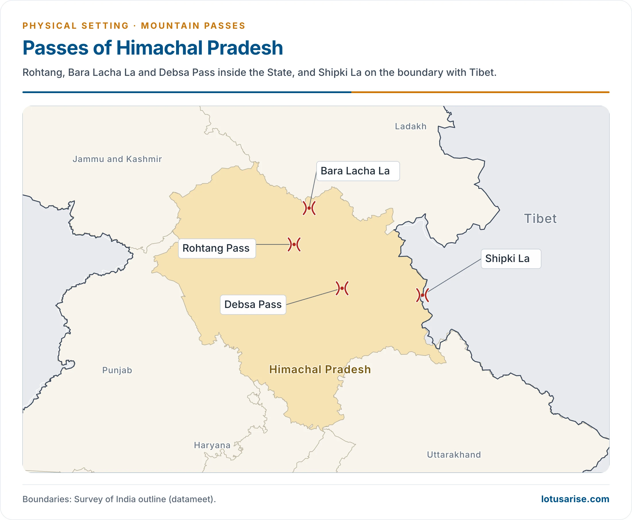
- Rohtang Pass (3,978 m, 13,051 ft): at the eastern end of the Pir Panjal, about 51 km from Manali. It joins the Kullu valley with Lahaul and Spiti.
- The name is usually read as “pile of corpses”, a mark of its old danger.
- It is on the Manali–Leh road. Military, public and tourist traffic long crowded it, until the Atal Tunnel (9.02 km) opened beneath it in October 2020.
- Bara Lacha La (about 4,890 m, 16,040 ft): on the Leh–Manali Highway, joining Lahaul in Himachal Pradesh with Leh district in Ladakh. It is placed in the Zaskar Range and carries snow in winter. An older height of 16,400 ft is also found.
- Shipki La (about 3,930 m): a border post on the boundary with Tibet in Kinnaur district, with a dozen substantial buildings. The Satluj enters India near it.
- The old Hindustan–Tibet Road, from Shimla to Gartok, used it.
- Local trade here has long been by barter.
- Debsa Pass (about 5,360 m, 17,590 ft): between the Kullu and Spiti districts, joining the Parvati valley with Spiti. It gives an easier and shorter option to the older Pin–Parvati Pass. Older figures are 5,270 m and 17,520 ft.
- Other passes: Kunzum (4,551 m) between Lahaul and Spiti; Shinku La or Shingo La (5,091 m) between Lahaul and Zanskar; Indrahar (4,342 m) in the Dhauladhar; Chanshal (3,749 m) in Shimla district; Lamkhaga (5,282 m) between Kinnaur and Harsil.
Uttarakhand
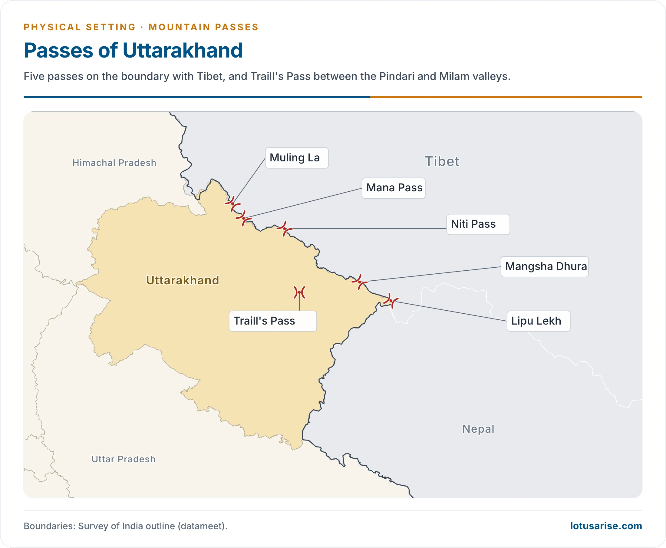
- Lipu Lekh (about 5,334 m, 17,500 ft): in Pithoragarh district, near the trijunction of India, Tibet and Nepal. It joins Uttarakhand with Tibet towards Taklakot (Purang), and is a border trading post and the Kailash Manasarovar route.
- Landslides in the rains and avalanches in winter make it hard.
- Nepal claims the area south of the pass. India holds that Kalapani is part of Pithoragarh district.
- Mana Pass (about 5,632 m, 18,478 ft): just north of Badrinath, in Chamoli district, on the boundary with Tibet.
- BRO built a road here for the military between 2005 and 2010, which rises to about 5,610 m. It is among the world’s highest vehicle-accessible passes.
- Snow closes it for about six months a year.
- Niti Pass (about 5,068 m): in the Greater Himalaya, joining Uttarakhand with Tibet. Some accounts give 5,800 m. It is snow-covered in winter, from about November to mid-May.
- Mangsha Dhura (over 5,000 m): in Pithoragarh district, at the head of the Kuthi valley. It was also a Manasarovar route, and landslides trouble it.
- Muling La (5,669 m): north of Gangotri, a seasonal pass to Tibet that snow closes in winter.
- Traill’s Pass (5,212 m, 17,100 ft): beyond the head of the Pindari Glacier, leading across to the Milam valley, on the Bageshwar–Pithoragarh line. It is steep and rugged, and is a mountaineers’ crossing rather than a trade route.
- Other names of this frontier: Thaga La, Marhi La, Kungri Bingri, Darma, Lampiya Dhura, Sin La, Auden’s Col and Mayali.
Sikkim
- Nathu La (4,310 m, 14,140 ft): in the Dongkya Range, in East Sikkim district, on the boundary with Tibet. It leads into the lower Chumbi valley.
- In Tibetan, Nathu means “listening ears” and La means “pass”.
- It was an offshoot of the old Silk Route. It closed after the 1962 war and reopened for trade in 2006.
- Jelep La (about 4,386 m, 14,390 ft): about 4 km south of Nathu La and a little higher. An older figure is 4,267 m (13,999 ft).
- It passes through the Chumbi valley, on the route that linked Kalimpong with Lhasa, and carried much of British India’s Tibet trade.
- Others: Goecha La (4,940 m), with its view of Kanchenjunga; Dongkha La (about 5,534 m); Naku La on the northern frontier.
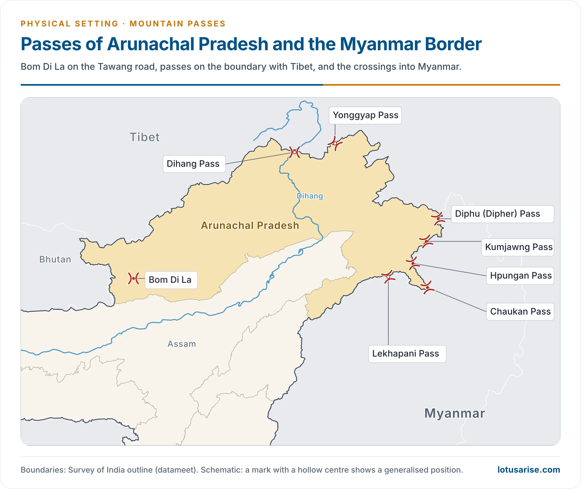
Arunachal Pradesh and the Myanmar Border
- Arunachal Pradesh is an integral part of India. China’s claim to it is rejected by India, which treats the McMahon Line (1914) as the boundary.
- Bom Di La: on the road to Tawang in West Kameng district, east of Bhutan. Older accounts give it 4,331 m and describe it as the way to Lhasa. Bomdila town itself stands at about 2,415 m.
- Bum La (about 15,200 ft): the actual border pass, 37 km from Tawang. It is a trading point and an agreed Border Personnel Meeting Point with China.
- Sela or Se La (about 4,170 m, 13,700 ft): on the Tawang road, between Tawang and West Kameng districts. It saw hard fighting in the 1962 war. The Sela Tunnel now bypasses it.
- Yonggyap Pass (3,962 m): on the boundary with Tibet in the far north.
- Dihang Pass (over 4,000 m): on the upper Dihang, giving passage towards Myanmar and Mandalay.
- Diphu or Dipher Pass (4,587 m): on the India–Myanmar border, and a strategic approach to eastern Arunachal Pradesh.
- China and Burma took their border to Diphu Pass under their treaty of October 1960. This lies about five miles south of the watershed.
- India objected. The point where India, Tibet and Myanmar meet lies near the Talu Pass, about five miles north of the Diphu Pass, on the watershed, so the two are separate places. The question is now part of the wider India–China dispute.
- Kumjawng Pass (2,929 m), Hpungan Pass (3,072 m) and Chaukan Pass (2,432 m): on the India–Myanmar border, joining Arunachal Pradesh with Myanmar.
- Pangsau Pass (1,136 m, 3,727 ft): on the crest of the Patkai Hills, and one of the easiest routes into Myanmar from the Assam plains. It is named after Pangsau village, 2 km beyond it.
- Lekhapani (Likhapani) Pass, on the same frontier, also leads to Myanmar.
Tunnels, All-Weather Roads and Border Work
- High passes close for months. The present strategy is to tunnel under them and keep strategic roads open all year.
| Work | Pass or route | Length | Position (date) |
|---|---|---|---|
| Atal Tunnel | Rohtang | 9.02 km | Open since October 2020 |
| Sela Tunnel | Se La, Tawang road | About 13,000 ft site | Dedicated 9 March 2024 |
| Sonamarg (Z-Morh) Tunnel | Gagangir to Sonamarg | About 6.4–6.5 km | Inaugurated 13 January 2025 |
| Zojila Tunnel | Zoji La, Sonamarg to Dras side | About 13.15 km | Breakthrough 9 June 2026; opening targeted for February 2028 |
| Shinku La Tunnel | Nimmu–Padum–Darcha road | About 4.1 km | Under construction; target 2028 |
| Likaru–Mig La–Fukche road | Mig La | 64 km | Completed October 2025 |
- The earlier Zojila target of 2026 was moved back. With the Sonamarg tunnel, it is meant to give the Srinagar–Leh axis all-weather road access.
- The Nimmu–Padum–Darcha road gives a further route to Ladakh, away from the frontier. Work on it is under BRO’s Project Yojak.
- BRO was set up in 1960, and its frontier road work is central to all of these.
- Mountain roads also bring costs: landslides, slope loss and heavy traffic in a fragile mountain setting.
Trade and Pilgrimage in the Present
- Border trade with Tibet runs through three agreed points: Lipulekh, Shipki La and Nathu La. India dates trade through Lipulekh to 1954. In modern times it reopened at Lipulekh in 1992 and Shipki La in 1994, and began at Nathu La in 2006.
- It stopped in 2020. At the Special Representatives’ talks of 19 August 2025, the two countries agreed to reopen it.
- Seasonal trade resumed at Nathu La and Shipki La on 1 August 2026, after about six years, and at Lipulekh in the same season.
- Kailash Manasarovar Yatra: resumed in 2025 after a gap of five years.
- In 2026, the Ministry of External Affairs chose 1,000 pilgrims in 20 batches of 50, with ten batches each through Lipulekh and Nathu La, from June to August.
- Nepal’s claim: on 3 May 2026 Nepal objected to the yatra through Lipulekh. India replied that trade through the pass has run since 1954, and called the claim a “unilateral artificial enlargement”. The international boundary with Nepal turns on the source of the Kali.
Passes of the Peninsula
- These are lower and open most of the year. Their importance lies in joining coast and plateau, or north India and the Deccan.
Western Ghats
- Thal Ghat, also Thul or Kasara Ghat (about 585 m): near Kasara in Maharashtra on the Mumbai–Nashik road. It is one of the four main road and rail routes into Mumbai.
- The railway climbs it at a gradient of 1 in 37, among the steepest on India’s main lines. The rack section of the Nilgiri Mountain Railway is steeper still.
- Bhor Ghat, also Bor or Bhore Ghat (about 622 m): on the crest between Palasdari and Khandala by rail, and Khopoli and Khandala by road. An older height is 441 m.
- It joins Mumbai and Pune. It was an ancient route developed by the Satavahanas, linking Konkan ports such as Chaul, Revdanda and Panvel with the Deccan.
- The Great Indian Peninsula Railway later took its Mumbai–Pune line through it.
- The Mumbai–Pune Expressway’s 13.3 km “Missing Link” between Khopoli and Kusgaon opened on 1 May 2026, bypassing the ghat stretch.
- Thal and Bhor give road and rail passage between the Konkan and the Deccan.
- Naneghat (about 750 m): between the Konkan coast and Junnar in Pune district, on the old trade route.
- Nane means “coin” and ghat means “pass”, because tolls were taken here. Its cave holds Satavahana inscriptions of the 2nd–1st century BCE.
- Malshej Ghat: in the Sahyadri, known for birds such as quails, rails, crakes, flamingos and cuckoos.
- Tamhini Ghat: between Mulshi and Tamhini in Pune district, known for green slopes, misty roads and waterfalls.
- Amba Ghat (about 2,000 ft): on the Ratnagiri–Kolhapur road, known for its scenery, pleasant climate and paragliding.
- Kumbharli Ghat (about 625 m): between Ratnagiri district in the Konkan and Satara district in the Desh, on the Chiplun–Karad road near the Koyna Dam.
- Amboli Ghat: joins Sawantwadi with Belgaum (Belagavi), and is noted for heavy rain, wildlife, dense forest, waterfalls and the Hiranyakeshi temple.
- Chorla Ghat (about 800 m): where Goa, Karnataka and Maharashtra meet, about 50 km from Panaji and 55 km from Belgaum. It is known for the barred wolf snake (Lycodon striatus).
- Palghat or Palakkad Gap (about 140 m): between the Nilgiri Hills to the north and the Anaimalai Hills to the south, joining Coimbatore in Tamil Nadu with Palakkad in Keralam (Kerala).
- This is the main break in the Western Ghats. It is 24–30 km wide, and the land in it runs from 75 to 300 m, against bordering hills of 1,500–2,000 m.
- It is probably a rift valley, formed by subsidence between two faults.
- Road and rail routes pass through it. It lets south-west monsoon moisture reach some way inland, towards the rain-shadow plateau.
- It has carried human migration across the southern tip throughout settled history.
- Shencottah (Shenkottai) Gap: joins Madurai in Tamil Nadu with Kottayam in Keralam.
- This is described as the second-largest gap in the Western Ghats. It lies about 5 km from Shencottah town.
- Road and rail lines through it join Shencottah with Punalur.
- Thamarassery Pass: on the road from the Kozhikode plain up to Wayanad, between old Malabar and Mysore.
Satpura and Central India
- Asirgarh Pass (about 260 m): in the Satpura Range in Madhya Pradesh, joining the Narmada and Tapi valleys.
- It is known as the “Key to the Deccan”, as one of the main routes from north India to the south. The Asirgarh Fort, about 20 km north of Burhanpur, overlooks it.
- In the Mughal era, Hindustan was taken to run from Delhi to Asirgarh, and the land beyond it was the Deccan.
- Burhanpur Gap: in Burhanpur district, where the Tapi and the Satpura act as natural limits. It lies north of the Tapi valley and carries National Highway 52 and main railway lines between the Ganga plain and the Deccan.
- Khandwa Gap: at Khandwa, a city in the Nimar region of Madhya Pradesh. It is a large railway junction, where the Malwa line from Indore meets the Mumbai–Kolkata line.
- Jabalpur Gap: named after Jabalpur (formerly Jubbulpore), a tier-2 city of Madhya Pradesh on the Narmada.
Aravalli
- Haldighati Pass: between Rajsamand and Udaipur districts, about 40 km from Udaipur.
- The name comes from its turmeric-coloured soil (haldi in Hindi).
- The Battle of Haldighati (1576) was fought here between Maharana Pratap of Mewar and the army of Emperor Akbar.
- The Government of India commissioned the Maharana Pratap National Memorial here in 1997, with a bronze statue of his horse Chetak.
- Goram Ghat: on the Rajsamand–Pali border, joining Mewar and Marwar.
- A railway line here crosses 2 tunnels and 172 bridges.
- It has dense Dhok forest, medicinal plants, and animals such as sloth bears, leopards and wild boars.
Passes Beyond the Frontier
- These lie today in Pakistan, but they have shaped Indian history.
Khyber Pass
- It lies in Khyber Pakhtunkhwa province of Pakistan, on the border with Afghanistan (Nangarhar Province), at about 1,070 m.
- It joins Landi Kotal with the Valley of Peshawar at Jamrud, across part of the Spin Ghar (Safed Koh) mountains.
- It was a part of the ancient Silk Road, with lasting cultural, economic and geopolitical value for Eurasian trade.
- Through history, it has been a main trade route between Central Asia and the Indian subcontinent, and a strategic military choke point for the powers that held it.
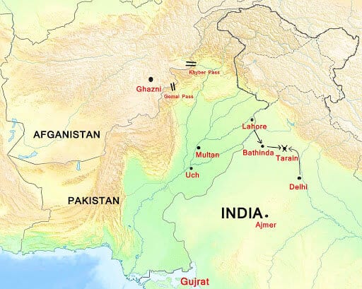
- On this map, read Afghanistan for “Afganistan” and Gujarat for “Gujrat”. It also marks the Gomal Pass to the south.
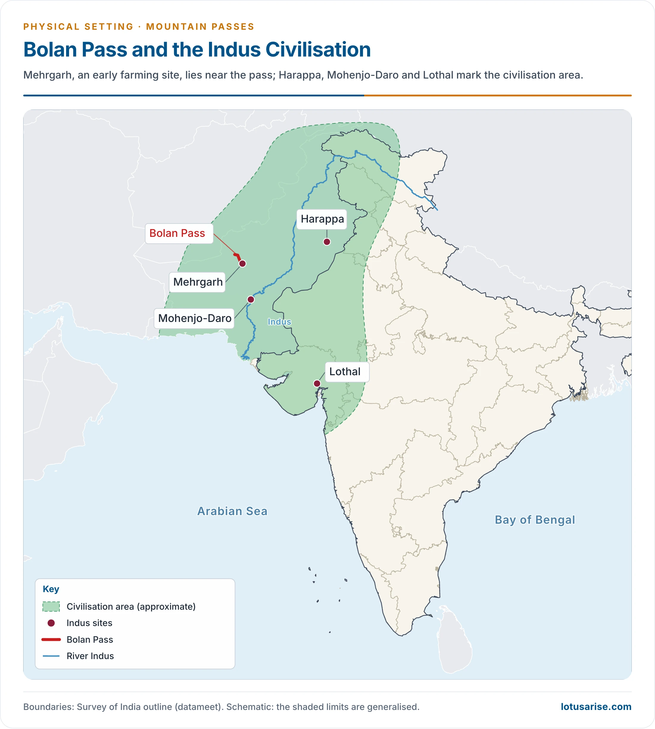
Bolan Pass
- It runs through the Toba Kakar Range of Balochistan province in western Pakistan, about 120 km from the Afghanistan border, at about 1,793 m. These mountains form a southern offshoot of the Himalayan arc.
- It is an 89 km stretch of the Bolan river valley, from Rindli in the south to Darwaza near Kolpur in the north, made up of narrow gorges and stretches.
- It lies south-east of Quetta, and joins Quetta with Sibi by road and rail.
- Mehrgarh, an early farming site of the subcontinent, lies near it.
List of Major Mountain Passes in India
- Heights are in feet. Where an older figure differs, it stands in brackets.
| Name | State or UT | Height (ft) | Between or separating |
|---|---|---|---|
| Asirgarh | Madhya Pradesh | about 850 | Narmada and Tapi valleys |
| Auden’s Col | Uttarakhand | 18,010 (17,552) | Rudugaira and Bhilangna valleys |
| Banihal Pass | Jammu and Kashmir | 9,291 | Jammu and Kashmir Valley |
| Bara Lacha La | Himachal Pradesh, Ladakh | 16,040 (16,400) | Lahaul and Leh |
| Bilafond La | Ladakh (Siachen) | 17,881 | Saltoro Ridge |
| Bomdila | Arunachal Pradesh | – | Road to Tawang |
| Chang La | Ladakh | 17,585 | Leh and Changthang |
| Chanshal Pass | Himachal Pradesh | 12,300 (peak 14,830) | Rohru and Dodra Kwar |
| Debsa Pass | Himachal Pradesh | 17,590 (17,520) | Kullu and Spiti |
| Dehra Compass | Ladakh (Aksai Chin) | Camp site | Old caravan route |
| Dhumdhar Kandi Pass | Uttarakhand | – | – |
| Diphu Pass | Arunachal Pradesh | 15,049 (4,587 m) | India and Myanmar |
| Dongkha La | Sikkim | 18,156 (12,000) | Sikkim and Tibet |
| Fotu La | Ladakh | 13,478 (13,451) | Kargil and Leh; highest on the highway |
| Goecha La | Sikkim | 16,207 | Trek pass below Kanchenjunga |
| Gyong La | Ladakh (Siachen) | 18,655 | Saltoro Ridge |
| Haldighati Pass | Rajasthan | About 1,227 | Rajsamand and Udaipur |
| Indrahar Pass | Himachal Pradesh | 14,245 (14,473) | Kangra and Chamba |
| Jelep La | Sikkim | 14,390 (14,300) | Sikkim and Tibet |
| Karakoram Pass | Ladakh | 18,176 | Ladakh and Xinjiang |
| Khardung La | Ladakh | 17,582 | Leh and Nubra |
| Kongka Pass | Ladakh | 16,965 | Ladakh and Aksai Chin |
| Kunzum Pass | Himachal Pradesh | 14,931 | Lahaul and Spiti |
| Lamkhaga Pass | Himachal Pradesh | 17,320 (17,336) | Kinnaur and Harsil |
| Lanak Pass | Ladakh | 17,933 | Ladakh and Tibet |
| Lipulekh Pass | Uttarakhand | 17,500 | Uttarakhand and Tibet |
| Lungalacha La | Ladakh | 16,600 | Leh–Manali road |
| Mana Pass | Uttarakhand | 18,478 | Uttarakhand and Tibet |
| Marsimik La | Ladakh | 18,314 | Chang Chenmo Range |
| Mayali Pass | Uttarakhand | 16,371 | Garhwal Himalaya |
| Mig La | Ladakh | about 19,400 | Likaru and Fukche |
| Nama Pass | Uttarakhand | 17,100 (18,399) | Pithoragarh district |
| Namika La | Ladakh | 12,139 | Kargil and Leh |
| Nathu La | Sikkim | 14,140 | Sikkim and Tibet |
| Niti Pass | Uttarakhand | About 16,627 (19,029) | Uttarakhand and Tibet |
| Palakkad Gap | Keralam, Tamil Nadu | About 460 (750) | Keralam and Tamil Nadu |
| Pensi La | Ladakh | 14,400 | Suru and Zanskar |
| Rezang La | Ladakh | About 18,045 | Chushul valley |
| Rohtang Pass | Himachal Pradesh | 13,051 | Manali and Lahaul |
| Sasser La | Ladakh | 17,753 | Nubra and upper Shyok |
| Sela Pass | Arunachal Pradesh | 13,700 (14,000) | Tawang and West Kameng |
| Shenkottai Pass | Keralam, Tamil Nadu | 690 | Travancore and Tamil Nadu; near Kollam |
| Shingo La | Himachal Pradesh, Ladakh | 16,703 | Lahaul and Zanskar |
| Shipki La | Himachal Pradesh | About 12,894 | Himachal Pradesh and Tibet |
| Sia La | Ladakh (Siachen) | 18,337 | Saltoro Ridge |
| Sin La | Uttarakhand | – | Pithoragarh district |
| Spangur Gap | Ladakh | About 16,100 | Ladakh and Tibet |
| Tanglang La | Ladakh | 17,480 (17,583) | Leh–Manali road |
| Thamarassery Pass | Keralam | 1,700 | Malabar and Mysore; Wayanad |
| Traill’s Pass | Uttarakhand | 17,100 | Pindari and Milam valleys |
| Umling La | Ladakh | 19,024 | Chisumle and Demchok |
| Zoji La | Jammu and Kashmir, Ladakh | 11,578 (12,400) | Kashmir and Ladakh |
Previous Year Questions
2023Map item: Nathula2022Map item: Bomdila2020Map item: Bum La2016Map item: Nathu La Pass2014Map item: Bhor Ghat2013Map item: Lipulekh Pass

amazing work
Thank You
so WOWW!!
good work
Chang la given wrong in map
Yeah, Chang La Pass is in the Ladakh Ranges between Leh and the Shyok River valley.
Thank You so much.
very nice
Super explain the passes
Thank you for your beautiful notes
can we skip rajtanil videos nd use lotus arise notes?
The location of Mangsha Dhura pass shown in the map of uttarakhand is incorrect. It lies in Pithoragarh district and you have shown it to the left of Mana and Niti passes which lie in Chamoli district.
Where is shenkottai
Amezing
very comprehensive …