

- The Desert Development Programme (DDP) was launched in 1977–78, on the advice of the National Commission on Agriculture (1976), for India’s hot sandy deserts and its high-altitude cold deserts.
- Its aim was to check desertification, restore the ecological balance and raise the productivity and incomes of desert people through better use of land, water, livestock and human resources.
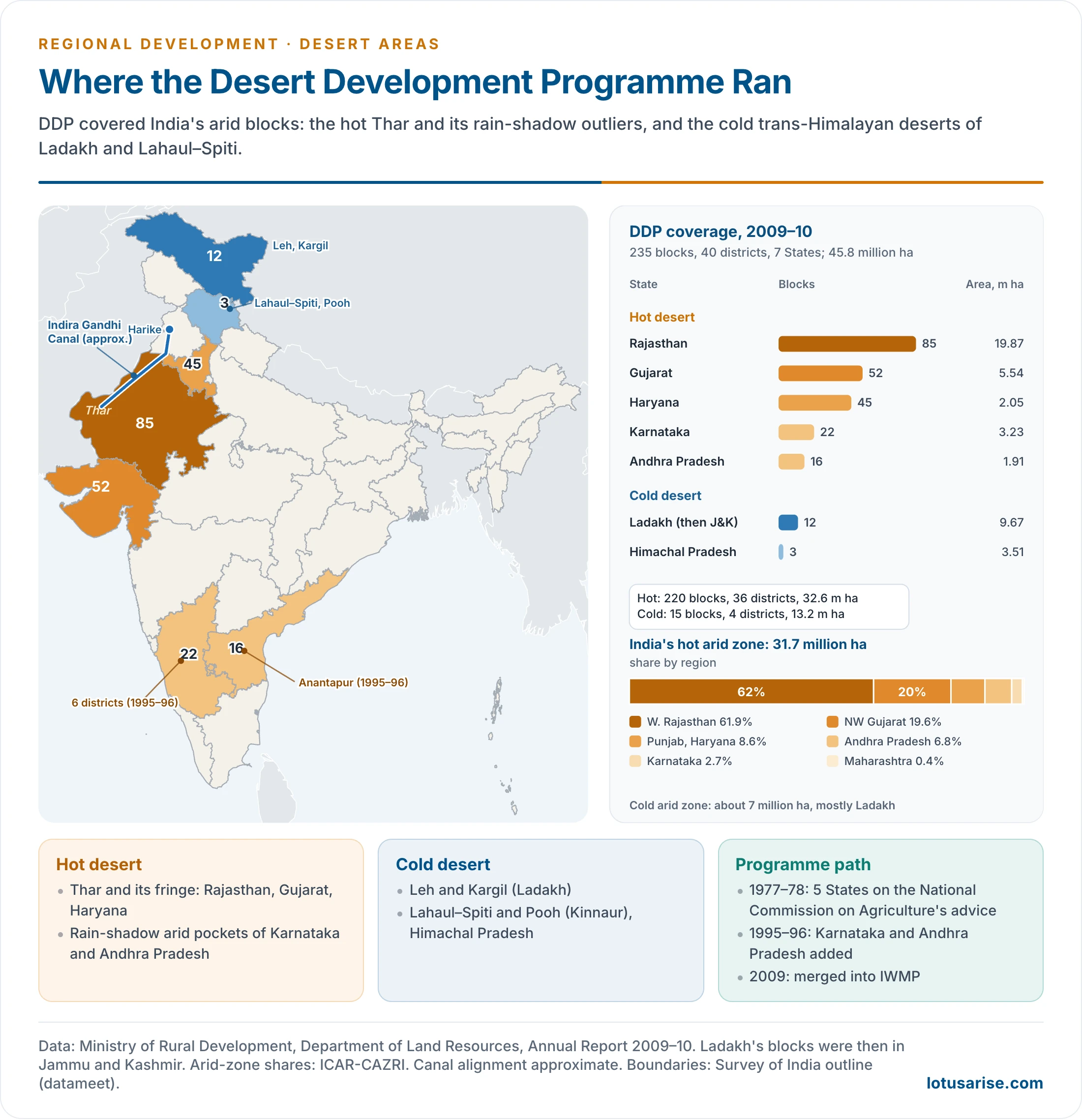
- It finally covered 235 blocks in 40 districts of seven States, from the Thar to Ladakh and Lahaul–Spiti.
- From 1995 it ran on a watershed basis. In 2009 it was merged with the Drought Prone Areas Programme and the Integrated Wastelands Development Programme into the IWMP, now the Watershed Development Component of PMKSY.
Desert Areas of India

Hot and Cold Deserts
- India’s arid zone covers about 38.7 million ha, roughly 12% of the country:
- 31.7 million ha of hot desert in the north-west and in pockets of the peninsula;
- about 7 million ha of cold desert in the trans-Himalaya.
- Hot arid zone:
- western Rajasthan holds about 62%, north-western Gujarat about 20%, and Punjab and Haryana about 9%;
- the rest lies in the rain-shadow of Andhra Pradesh (Anantapur), Karnataka and a sliver of Maharashtra.
- Its eastern edge follows a moisture index of –66.6, roughly along the foot of the Aravalli range.
- Cold arid zone:
- Ladakh (Leh and Kargil) makes up most of it;
- Lahaul–Spiti and part of Kinnaur (Pooh) in Himachal Pradesh hold the rest.
- It lies in the rain-shadow of the Great Himalaya, at 2,900–5,900 m.
- The Thar is the core of the hot desert. Sand dunes cover about 48% of western Rajasthan, and aeolian landforms dominate over 80% of the land.
| Basis | Hot desert (Thar and fringe) | Cold desert (Ladakh, Lahaul–Spiti) |
|---|---|---|
| Location | Western Rajasthan, Kachchh, south-west Haryana, rain-shadow peninsula | Trans-Himalaya, leeward of the Great Himalaya |
| Rainfall | About 100–420 mm, highly variable | About 100 mm or less, mostly as snow |
| Temperature | Summer near 50 °C, cold winter nights | Winters down to –30 °C; short growing season |
| Main land problem | Moving sand, wind erosion, salinity | Thin gravelly soil, frost, slope erosion |
| Water source | Rain, deep groundwater, canals | Snow and glacier melt in streams |
| Livelihood | Livestock, rainfed millets, canal farming | Barley and wheat in oases, pashmina goats, yak, tourism |
| Special treatment | Shelterbelts, dune fixing, water harvesting | Irrigation channels, artificial glaciers, willow and poplar plantations |
Problems of Desert Areas
- Scanty and unreliable rain. Much of Rajasthan and adjoining Haryana and Gujarat gets under 400 mm. Barmer and Jaisalmer get around 200 mm or less.
- Variability reaches 40–50%, so famine follows any shortfall.
- High evaporation. Potential evapotranspiration of 1,500–2,000 mm a year is several times the rainfall.
- Loose sandy soils are blown away by strong summer winds; moving dunes bury fields, roads and canals.
- Limited crop choice. Only bajra, jowar, moth, guar, barley and pulses survive rainfed, with low yields and low prices.
- Salinity and deep, brackish groundwater in many tracts.
- Poverty and weak infrastructure: markets, storage, transport and services are thin over a dispersed settlement pattern.
- Distress migration of people and herds in drought years, when food and fodder run out.
- Cold-desert problems: a growing season of about five months, roads closed by snow for much of the winter, little arable land, and total dependence on glacier-fed streams.
Desertification
- Desertification is land degradation in arid, semi-arid and dry sub-humid areas, caused by climatic variation and human activity.
- Desertification and Land Degradation Atlas of India (SAC–ISRO, 2021):
- 97.85 million ha (29.7% of India) was degraded in 2018–19, up from 94.53 million ha in 2003–05;
- 83.69 million ha of it lay in the drylands and counts as desertification.
- The leading processes were water erosion, vegetation degradation and wind erosion.
- Rajasthan, Maharashtra, Gujarat, Karnataka, Ladakh, Jharkhand, Odisha, Madhya Pradesh and Telangana together account for most of it.
- Human causes: overgrazing, cutting of shrubs for fuel, cultivation of fragile sandy land with tractors, over-pumping of groundwater and poorly drained canal irrigation.
The Desert Development Programme
Origin
- National Commission on Agriculture (1976): asked for a special programme to halt the spread of the desert and develop its resources.
- Launch (1977–78): a centrally sponsored scheme in the hot desert of Rajasthan, Gujarat and Haryana and the cold desert of Jammu and Kashmir (Ladakh) and Himachal Pradesh (Lahaul–Spiti).
- It began in about 132 blocks of five States.
- Task Force under M. S. Swaminathan (1982): proposed an intensive programme to progressively eliminate desert characteristics.
- It trimmed a few blocks and added the Pooh sub-division of Kinnaur.
- Seventh Plan: 131 blocks in 21 districts of five States, over about 3.62 lakh sq km and 15 million people (1981).
- Hanumantha Rao Committee (1994): redrew coverage by moisture index, placing all arid blocks under DDP.
- 64 blocks moved from DPAP to DDP.
- From 1995–96 the programme was extended to six districts of Karnataka and one district of Andhra Pradesh (Anantapur).
- It now ran on watershed lines under the 1995 guidelines.
Objectives
- Mitigate the adverse effects of desertification and harsh climate on crops, people and livestock, and combat the spread of the desert.
- Restore ecological balance by harnessing, conserving and developing land, water and vegetation, and raise land productivity.
- Raise incomes and employment of the village community, particularly the resource-poor.
- Make optimum use of local resources and improve the living standard of desert people.
Coverage
- 235 blocks in 40 districts of seven States, over an identified area of about 45.8 million ha (2009–10):
- hot desert: 220 blocks in 36 districts of Rajasthan, Gujarat, Haryana, Karnataka and Andhra Pradesh;
- cold desert: 15 blocks in 4 districts of Jammu and Kashmir (now Ladakh) and Himachal Pradesh.
- Rajasthan alone had 85 blocks in 16 districts and about 19.9 million ha, over two-fifths of the programme area.
| State | Desert type | Districts | Blocks | Identified area (million ha) |
|---|---|---|---|---|
| Rajasthan | Hot | 16 | 85 | 19.87 |
| Gujarat | Hot | 6 | 52 | 5.54 |
| Haryana | Hot | 7 | 45 | 2.05 |
| Karnataka | Hot | 6 | 22 | 3.23 |
| Andhra Pradesh | Hot | 1 | 16 | 1.91 |
| Jammu and Kashmir (Ladakh) | Cold | 2 | 12 | 9.67 |
| Himachal Pradesh | Cold | 2 | 3 | 3.51 |
| Total | 40 | 235 | 45.79 |
- The dividing line with DPAP was aridity: DDP took the arid blocks with a moisture index below –66.7; the Drought Prone Areas Programme took the semi-arid and dry sub-humid blocks.
Components in the Hot Desert
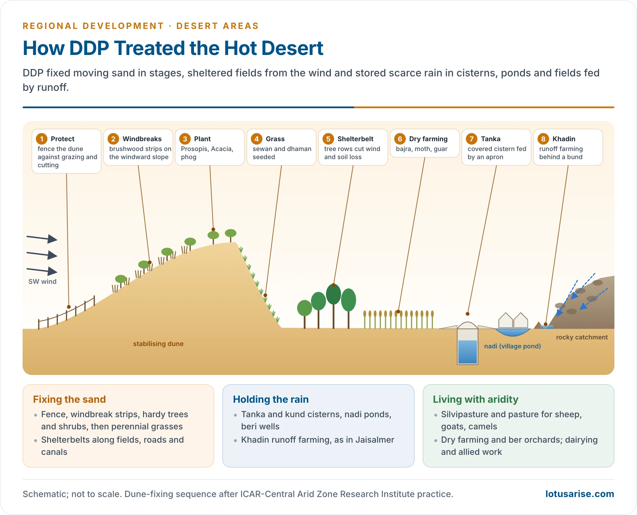
- Sand dune stabilisation, the signature work, follows a sequence developed at the Central Arid Zone Research Institute (CAZRI, Jodhpur, 1959):
- protect the dune from grazing and cutting;
- erect micro-windbreaks of brushwood in parallel strips or a checkerboard on the windward slope;
- plant hardy trees and shrubs such as Prosopis juliflora, Acacia tortilis, Acacia senegal and phog (Calligonum);
- sow perennial grasses such as sewan (Lasiurus sindicus) and dhaman (Cenchrus).
- Shelterbelts and windbreaks of several tree rows across the wind along fields, roads and canals. They cut wind speed, soil loss and evaporation.
- Afforestation and silvipasture on village commons and degraded land, for fuel and fodder.
- Pasture development for the livestock economy: sheep, goats, camels and cattle.
- Water harvesting in traditional forms:
- tanka (covered cisterns), kund, nadi (village ponds), beri (shallow percolation wells);
- khadin, runoff farming behind earthen bunds, as practised in Jaisalmer since the 15th century.
- Dry farming: crops needing little water (bajra, jowar, moth, guar, pulses, oilseeds); new fodder technologies.
- Allied activities for small and marginal farmers: dairying, poultry, horticulture (ber), sheep rearing, bee-keeping, agroforestry.
- Reclamation of waterlogged land in the Indira Gandhi Canal command.
- Wider measures:
- DDP was made part of the Twenty Point Programme;
- NGOs were brought into implementation;
- eco-friendly pesticides were promoted.
Components in the Cold Desert
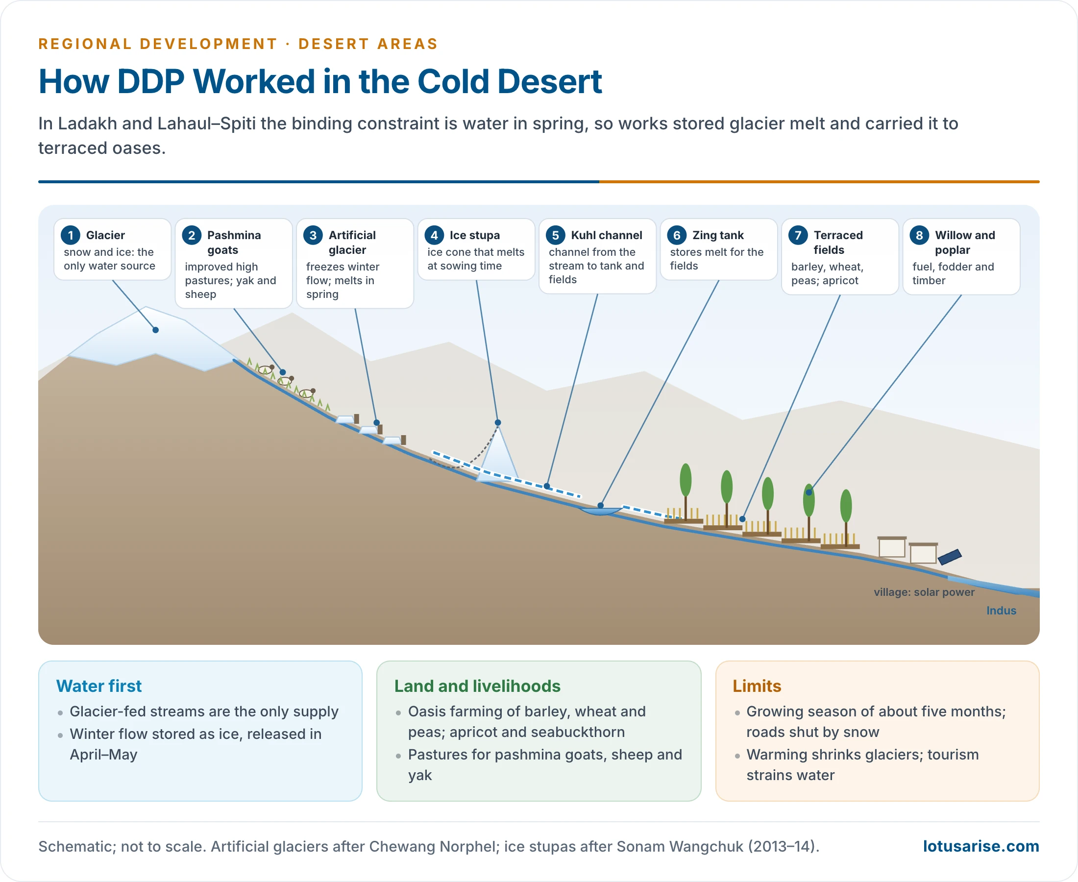
- Irrigation comes first, because snow and glacier melt are the only water. Works include:
- channels from glacier-fed streams (kuhls in Lahaul–Spiti and Kinnaur) and village tanks (zing in Ladakh);
- artificial glaciers, pioneered by Chewang Norphel in Ladakh, which freeze autumn and winter flow in shaded valleys and release it in early spring, when crops need water;
- ice stupas, conical ice towers devised by Sonam Wangchuk in 2013–14 that melt slowly into the sowing season.
- Afforestation with willow and poplar along channels, for fuel, fodder and timber.
- Pasture and livestock: improved pastures for pashmina goats, sheep and yak.
- Horticulture and oasis farming: apricot, apple and seabuckthorn; vegetables in greenhouses during the short season.
- Renewable energy: solar heating and power, given high insolation and costly fuel.
Funding and Implementation
- Until March 1999 the central share varied by area:
- 75% in hot arid non-sandy areas;
- 100% in hot arid sandy areas and in the cold desert.
- From 1 April 1999 new projects were funded 75:25 by the Centre and the States.
- Project cost: ₹22.5 lakh (non-sandy hot areas) or ₹25 lakh (other areas) per watershed project until 1999–2000. From 2000 it was a uniform ₹30 lakh per project of about 500 ha (₹6,000 per ha).
- Funds went to District Rural Development Agencies or Zila Parishads. Watershed committees, later Gram Panchayats under the Hariyali Guidelines (2003), carried out the work.
- Scale: 15,746 projects over about 7.87 million ha were sanctioned from 1995–96. About ₹2,724 crore had been released by December 2009.
The Indira Gandhi Canal and the Desert
The Canal
- The Rajasthan Canal, conceived by the engineer Kanwar Sain in 1948, was begun on 31 March 1958. It was renamed the Indira Gandhi Canal in 1984.
- It draws water of the Ravi–Beas system from the Harike barrage in Punjab, at the confluence of the Satluj and the Beas.
- A 204 km feeder runs through Punjab and Haryana to Rajasthan, followed by a 445 km main canal parallel to the Pakistan border, deep into Jaisalmer.
- Its planned culturable command area is about 19.6 lakh ha:
- Stage I (about 5.5 lakh ha) in Sri Ganganagar, Hanumangarh and northern Bikaner, on gently undulating land;
- Stage II (about 14 lakh ha) in Bikaner, Jaisalmer, Barmer, Jodhpur, Nagaur and Churu, among shifting dunes and largely by lift.
- Field channels, warabandi, lining and drainage in its command are carried out under the command area development programme.
Effects on the Desert
- Gains:
- wheat, cotton, mustard and groundnut now grow where only rainfed bajra and guar grew;
- drinking water reaches towns and villages far beyond the command;
- settled farming, less seasonal migration and denser settlement;
- canal-side shelterbelts and block plantations fix dunes and green the landscape;
- fodder supply for the livestock economy.
- Costs:
- seepage, waterlogging and secondary salinity, worst in Stage I and in the low-lying inter-dune basins;
- spread of malaria and of the invasive Prosopis juliflora;
- loss of desert grassland habitat, with harm to the endemic wildlife of the Thar;
- unequal benefits between head and tail reaches, and between allottees and the landless.
- The lesson for desert planning: irrigation is not the same as development. It needs drainage, lining, crop rules and dune fixing to last.
Merger and Dry-Area Policy
From DDP to the Watershed Component
- IWMP (26 February 2009) merged DDP, DPAP and IWDP into one programme of larger watershed clusters, with 90:10 funding and a livelihood component.
- PMKSY (2015–16) absorbed IWMP as its Watershed Development Component. WDC-PMKSY 2.0 (2021–26, extended to September 2026) continues watershed work in the desert districts.
- Its unit cost is ₹28,000 per ha in difficult areas, which include deserts.
- Within India’s watershed management framework, DDP’s distinctive legacy is the dune, shelterbelt and cold-desert water techniques it took to scale.
Programmes and Policy for Dry Areas
- Dry areas include the arid, semi-arid and dry sub-humid zones, where rainfall is low and erratic and agriculture is rainfed. Policy for them has passed through three phases.
- Area programmes (1970s–1990s):
- DPAP (1973–74) and DDP (1977–78) for drought-prone and desert blocks;
- the Integrated Wastelands Development Programme (1989–90) for degraded land elsewhere;
- the National Watershed Development Project for Rainfed Areas (1990–91) under the Ministry of Agriculture.
- Watershed and rainfed-area framework (1995 onward):
- common watershed guidelines (1995, 2001), Hariyali (2003) and the Common Guidelines (2008);
- the National Rainfed Area Authority (2006);
- IWMP (2009) and the PMKSY watershed component (2015);
- Rainfed Area Development under the National Mission for Sustainable Agriculture (2014–15).
- Land-degradation and climate framework:
- the UN Convention to Combat Desertification, which India ratified in 1996;
- the National Action Programme to Combat Desertification (2001);
- a target of restoring 26 million ha of degraded land by 2030 (land degradation neutrality);
- the Aravalli Green Wall Project (June 2025), greening a 5 km buffer around the Aravallis in 29 districts of Gujarat, Rajasthan, Haryana and Delhi to stop the desert’s eastward spread.
- Supporting instruments:
- water conservation works under the rural employment guarantee (VB-G RAM G, formerly MGNREGA);
- CAZRI research on dunes, silvipasture and arid horticulture;
- drought relief under the Manual for Drought Management;
- solar parks that turn desert land into an energy resource, such as Bhadla (2,245 MW) in Jodhpur district.
- Principles of dry-area policy:
- treat land, water, vegetation and livestock together, by watershed;
- put livestock and pasture at the centre in the arid zone;
- protect the commons;
- match crops to water;
- plan with people and Panchayats;
- link conservation to incomes.
| Programme | Year | Ministry | Area | Status |
|---|---|---|---|---|
| DPAP | 1973–74 | Rural Development | Semi-arid, dry sub-humid blocks | Merged into IWMP, 2009 |
| DDP | 1977–78 | Rural Development | Hot and cold arid blocks | Merged into IWMP, 2009 |
| IWDP | 1989–90 | Rural Development | Wastelands outside DPAP and DDP | Merged into IWMP, 2009 |
| NWDPRA | 1990–91 | Agriculture | Rainfed watersheds | Subsumed in later rainfed missions |
| IWMP, then WDC-PMKSY | 2009; 2015–16 | Rural Development (Land Resources) | All rainfed and degraded land | Running (WDC 2.0 to September 2026) |
| Rainfed Area Development | 2014–15 | Agriculture | Rainfed farming systems | Running under NMSA |
Evaluation
Achievements
- DDP slowed the advance of sand around protected villages, roads and canals, and showed that dunes can be fixed and grazed sustainably.
- It spread shelterbelts, silvipasture and traditional water harvesting across the Thar, and artificial glaciers in Ladakh.
- It created employment and durable assets in some of India’s poorest districts, and fed its methods into the national watershed programme.
Shortcomings
- Activities were thinly spread over vast areas and often unrelated to desertification, the same flaw the Hanumantha Rao Committee found in DPAP.
- Departmental delivery with weak participation; plantations failed where grazing was not controlled.
- Targeting was faulty: small and marginal farmers and labourers gained less than larger landholders.
- Shortage of skilled staff, delays and poor information.
- Desertification continued. The 2021 atlas shows degraded land still rising in most States.
- Irrigation without drainage in the canal command added new forms of degradation.
Way Forward
- Livestock-centred planning for the arid zone: grazing rights, pasture banks and fodder security.
- Commons first: restore oran and gochar (sacred groves and village pastures) with community rules.
- Water discipline: lined canals, drainage, drip irrigation and limits on groundwater use.
- Cold desert: glacier-melt storage, solar energy and carrying-capacity limits on tourism in Ladakh.
- Renewable energy with care for land: solar parks that leave grazing corridors and avoid grassland habitat.
- Steady funding and long projects, with outcomes measured by satellite rather than by structures built.
Previous Year Questions
2003Discuss the programmes and policy of development of dry areas in India.




