

- Ocean (marine) deposits are the sediments that accumulate on the sea floor: rock debris from the land, the hard remains of marine organisms, minerals precipitated from seawater and a trace of dust from space.
- They form the largest sedimentary system on Earth. Almost the whole ocean floor carries some sediment, from a thin film on young ridge crests to more than 10 km beneath passive margins and the great deep-sea fans.
- Their study tells us where the sediment came from, how it travelled and settled, and what the ocean and climate were like when it was laid down.
- Most sedimentary rocks on the continents began as marine deposits, later lithified and lifted by plate movement. The fossil-bearing limestones near the summit of Mount Everest are one example.
Classification of Ocean Deposits

Bases of classification
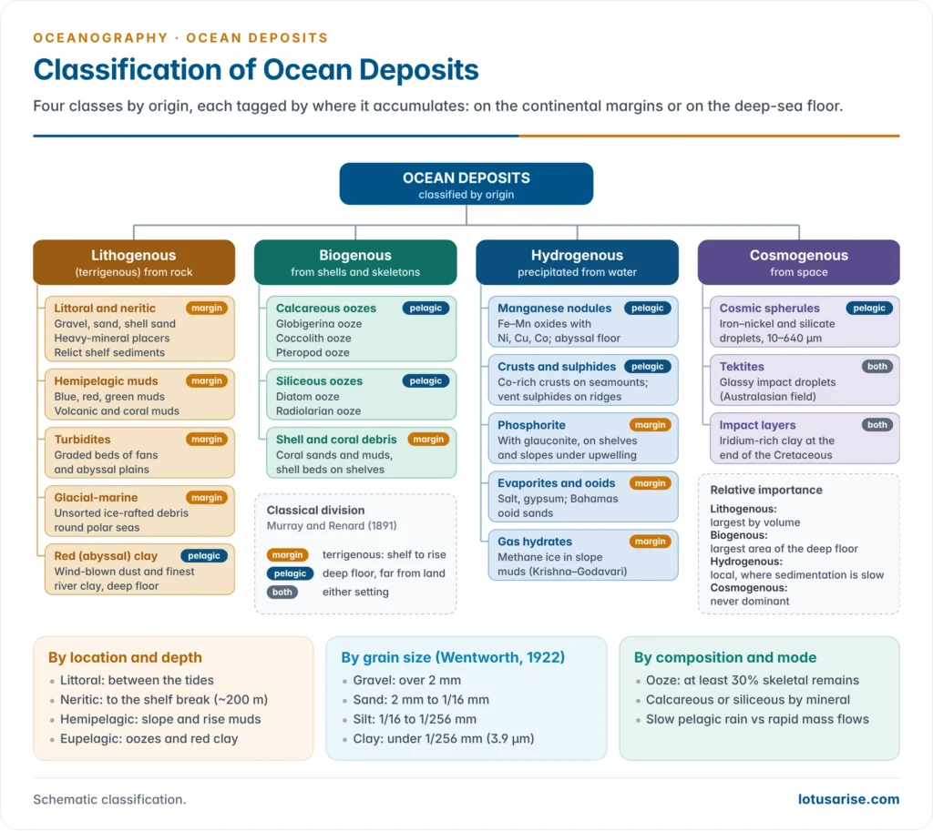
- No single scheme serves every purpose. Deposits are grouped by origin, by location and depth, by grain size, and by mode of deposition. The schemes overlap, so a globigerina ooze is at once biogenous, pelagic and fine-grained.
By origin (genetic classification)
- The modern standard scheme groups sediments by their source into four types:
| Type | Source | Main components | Where it dominates |
|---|---|---|---|
| Lithogenous (terrigenous) | Weathered rock from land, volcanoes and the sea floor | Gravel, sand, silt, clay, volcanic ash | Shelves, slopes, rises, polar seas, deep clays |
| Biogenous | Hard parts of organisms | Calcareous and siliceous tests, shells, coral | Deep floor away from land; reef shelves |
| Hydrogenous (authigenic) | Precipitation from seawater or pore water | Manganese nodules, phosphorite, glauconite, evaporites, sulphides | Small areas of slow sedimentation or special chemistry |
| Cosmogenous | Space dust and impact debris | Iron–nickel spherules, tektites | Nowhere; a trace in slow-forming clays |
- Lithogenous sediment is by far the largest by volume. Biogenous sediment covers the largest area of the deep floor.
By location and depth
- Sir John Murray and Alphonse-François Renard, in their report on the Challenger deep-sea deposits (1891), made the classical two-fold division:
- Terrigenous deposits: coarse, land-derived, laid down on and near the continental margins.
- Pelagic deposits: fine, open-ocean sediment of the deep floor, either oozes or red clay.
- A fuller depth-zone scheme follows the floor from the shore outward:
| Zone | Depth | Typical deposits |
|---|---|---|
| Littoral | Between high and low tide | Gravel, sand, shell fragments, beach placers |
| Neritic (shallow-water) | Low tide to the shelf break, about 200 m | Sands, silts, shell and coral sands, glauconite |
| Hemipelagic (bathyal) | Slope and rise, about 200–4,000 m | Blue, red, green, volcanic and coral muds; turbidites |
| Eupelagic (abyssal) | Deep floor, mostly below 4,000 m | Calcareous and siliceous oozes, red clay, nodules |
- Hemipelagic deposits are mixed: part land-derived, part marine. Eupelagic deposits are almost wholly marine, wind-borne and cosmic.
By grain size (texture)
- The Wentworth scale, set out by Chester Keeler Wentworth (1922) on the earlier grades of Johan August Udden, divides sediment by particle diameter. Each class is half the size of the one above it:
- gravel, over 2 mm (boulders, cobbles, pebbles and granules);
- sand, 2 mm to 1/16 mm (62.5 µm);
- silt, 1/16 mm to 1/256 mm (3.9 µm);
- clay, under 1/256 mm.
- Grain size records the energy of deposition. Waves and strong currents leave only coarse grains; calm, deep water lets clay settle.
- Sorting (how uniform the grains are) and rounding add detail. Beach sand is well sorted, while glacial deposits are poorly sorted.
- Roger Revelle (1944) used the sand–silt–clay proportions to group deep-sea sediments into sands, silty sands, sandy silts, silty muds and clayey muds.
By mode of deposition
- Particle-by-particle settling (pelagic rain, or marine snow) builds the oozes and clays, very slowly.
- Mass (bulk) emplacement by slumps, debris flows and turbidity currents dumps thick beds in hours.
Terrigenous Deposits
- Terrigenous (lithogenous) deposits are rock fragments produced by weathering and erosion, mostly on land.
- Rivers supply most of it. They carry roughly 15–20 billion tonnes of suspended sediment a year to the coast, although dams now trap a growing share.
- Wind carries desert dust far out to sea. Saharan dust crossing the Atlantic is the largest plume.
- Glaciers and icebergs drop rock debris of every size.
- Volcanoes add ash and pumice. Coastal erosion and landslides feed the shore directly.
- Grain size falls with distance from land: gravel near the shore, then sand, silt and finally mud. Waves, tides, storms and slumping often disturb this sequence.
- The minerals reflect the source rocks. Quartz, hard and resistant, dominates sands, with feldspar, mica and clay minerals.
Littoral and neritic deposits
- Gravels and sands cover most inner shelves. Waves sort out the dense heavy minerals (ilmenite, rutile, zircon, garnet, monazite, magnetite) into placer deposits.
- India’s beach placers at Chavara (Kerala), Manavalakurichi (Tamil Nadu) and Chhatrapur (Odisha) are worked for ilmenite, rutile, zircon and monazite.
- Relict sediments cover much of the outer shelf. They were laid down when the sea stood about 120 m lower in the last glacial period and are out of equilibrium with the present sea.
- Off India’s west coast the outer shelf carries relict carbonate sands and ooids from that lowstand.
- In warm, clear seas shell and coral sands replace land sand. They are biogenous, though deposited on the shelf, as around the coral reefs of the Bahamas, Florida and Lakshadweep.
Hemipelagic muds
- Muds are mixtures of silt and clay that settle in quieter water on the outer shelf, slope and rise. Murray classified them by colour, which records their chemistry:
| Mud | Cause of colour | Where found |
|---|---|---|
| Blue mud | Iron sulphide and organic matter in oxygen-poor mud; often a thin reddish oxidised surface film | Most widespread mud: deep margins and enclosed seas such as the Mediterranean, Arctic, Black Sea |
| Red mud | Abundant iron oxide from rivers draining lateritic land | Off Brazil (Amazon), Yellow Sea (Huang He) |
| Green mud | Glauconite, an iron–potassium silicate formed on the sea floor | Off high coasts with few large rivers: California, Japan, Australia, near the Cape of Good Hope |
| Volcanic mud | Weathered lava, ash and pumice | Round volcanic islands: Hawaii, Iceland, Indonesia |
| Coral mud | Fine debris of reef carbonate | Round reefs: Caribbean, Great Barrier Reef |
Turbidites and glacial-marine deposits
- Turbidites are the beds left by turbidity currents. Each fines upward (graded bedding), carrying shelf sand and even shallow-water shells far into the abyss.
- They build the deep-sea fans and the abyssal plains of the Atlantic and Indian Oceans. Trenches trap them round most of the Pacific.
- The process is active today. In January 2020 a turbidity current set off by a Congo River flood ran more than 1,100 km down the Congo Canyon at up to 8 m/s, breaking the SAT-3 and WACS telecommunication cables.
- Glacial-marine deposits are unsorted mixtures of clay to boulders, dropped by melting ice.
- They ring Antarctica and floor the northern North Atlantic and Arctic.
- Ice-rafted debris layers in North Atlantic cores, the Heinrich layers described by Hartmut Heinrich (1988), record great iceberg discharges in the last glacial period.
Pelagic Deposits
- Pelagic deposits are the fine sediments of the open deep ocean, far from land. They cover about three-quarters of the ocean floor.
- A pelagic sediment is an ooze if at least 30% of it is skeletal remains of plankton. Otherwise it is a clay.
- The rest of an ooze is usually clay.
- Pelagic sediment accumulates very slowly:
| Sediment | Typical rate of accumulation |
|---|---|
| Terrigenous, near large rivers | Tens of centimetres to metres per 1,000 years |
| Calcareous and siliceous oozes | About 1–3 cm per 1,000 years |
| Red clay | About 1 mm per 1,000 years or less |
| Manganese nodules | A few millimetres per million years |
Biogenous oozes
- Oozes are made of tests, the tiny shells of phytoplankton (diatoms, coccolithophores) and zooplankton (foraminifera, radiolarians, pteropods).
- A single test can take years to sink. Most reach the floor in days to weeks, packed into the faecal pellets of animals that ate them, or inside sinking marine snow.
- Because of this rapid delivery, the ooze beneath an area mirrors the plankton living above it.
- Three processes decide whether an ooze forms:
- Productivity: how many tests are made in the surface water;
- Destruction: how many dissolve on the way down or on the bottom;
- Dilution: how much other sediment, usually land-derived, masks them.
Calcareous oozes
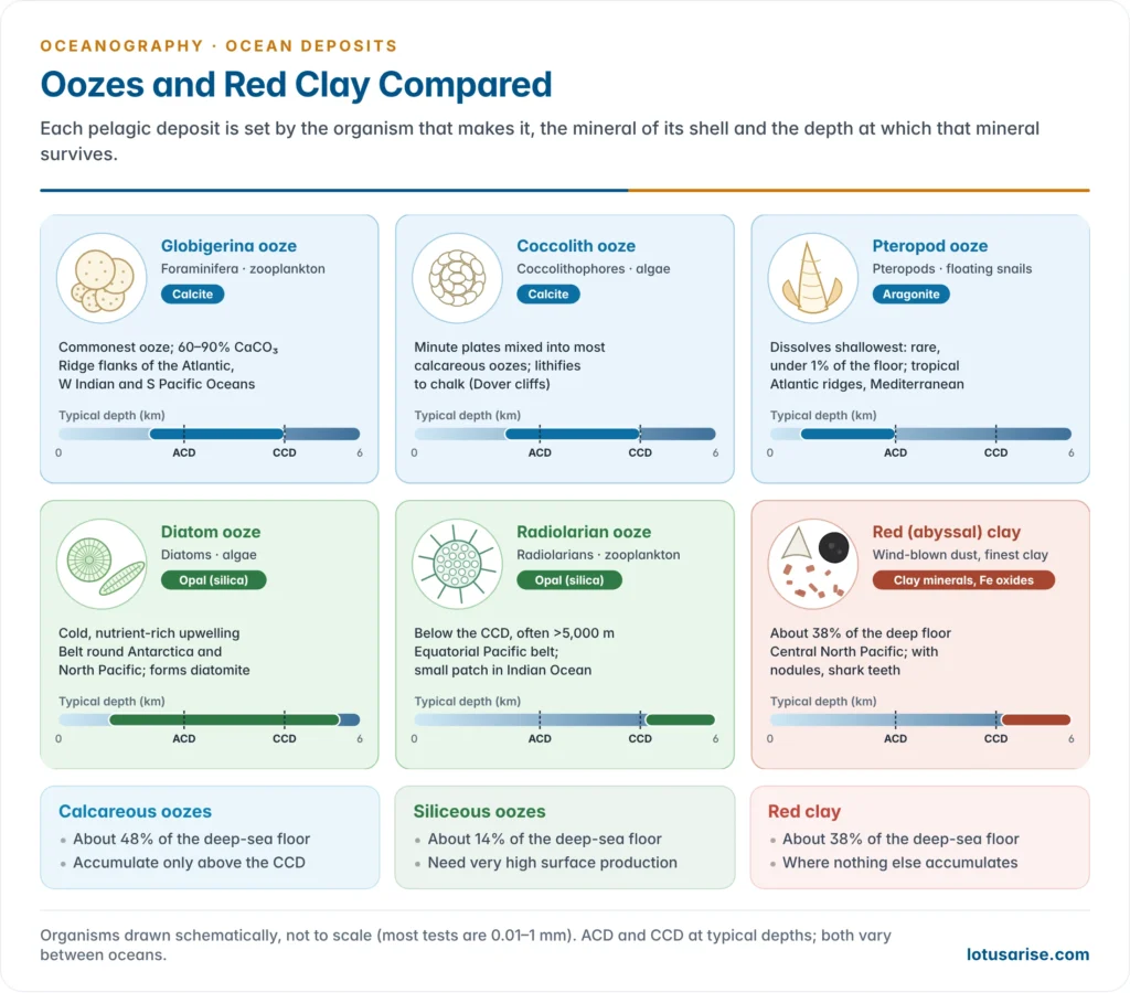
- Calcareous oozes contain more than 30% calcium carbonate tests. They are the most widespread pelagic deposit, covering about 48% of the deep-sea floor.
- Globigerina (foraminiferal) ooze is built of the chambered tests of planktonic foraminifera, especially Globigerina.
- It is white to cream, commonly 60–90% CaCO₃, and is the commonest ooze.
- It covers the flanks of mid-ocean ridges and rises in tropical and temperate seas, generally between about 2,000 and 4,500 m.
- It is extensive in the Atlantic, the western Indian Ocean and the South Pacific. The warm North Atlantic Drift carries it beyond the Arctic Circle off Norway.
- Coccolith ooze is made of the minute calcite plates (coccoliths) of coccolithophores, single-celled algae such as Emiliania huxleyi.
- Coccoliths are mixed into most calcareous oozes. Lithified, they form chalk; the White Cliffs of Dover are Cretaceous coccolith ooze.
- Pteropod ooze is made of the thin, conical shells of pteropods, small floating snails.
- The shells are aragonite, a more soluble form of CaCO₃, so they dissolve at shallower depths than calcite.
- The ooze is therefore rare, covering well under 1% of the floor. It is confined to warm, shallow ridges and plateaus, mostly in the tropical Atlantic (near the Azores, Bermuda and the Antilles) and the Mediterranean.
Siliceous oozes
- Siliceous oozes contain more than 30% opal (silica) tests. They cover about 14% of the deep-sea floor.
- Seawater is undersaturated in silica at all depths, so most siliceous tests dissolve. An ooze forms only where production is very high, under upwelling of nutrient-rich water, and where carbonate is absent or dissolved.
- Diatom ooze is made of the frustules of diatoms, single-celled algae.
- It forms a broad belt round Antarctica south of the Antarctic Polar Front, and a belt across the North Pacific from the Bering Sea and Sea of Okhotsk to the Gulf of Alaska.
- It also occurs under coastal upwellings.
- A 2015 census of about 14,500 sea-floor samples found that diatom ooze tracks cold, nutrient-rich surface water more closely than productivity alone.
- Lithified, it forms diatomite (diatomaceous earth), used in filters and abrasives.
- Radiolarian ooze is made of the intricate skeletons of radiolarians, single-celled zooplankton.
- It lies in an equatorial belt under the upwelling of the central and eastern Pacific, and in a small patch in the eastern Indian Ocean.
- It is usually deeper than the CCD, often below 5,000 m, where the carbonate has dissolved and only the silica remains. Lithified, it forms radiolarian chert.
Red (pelagic) clay
- Red clay (brown or abyssal clay) is the most extensive single pelagic deposit. It covers about 38% of the deep-sea floor, and about half of the Pacific.
- It forms where nothing else accumulates: deeper than the CCD, too far from land for coarse sediment, and under unproductive water. The central North Pacific is the type area.
- Composition:
- mostly clay minerals (illite, kaolinite, smectite), with fine quartz and decomposed volcanic ash;
- zeolites (phillipsite), manganese micronodules and cosmic spherules;
- shark teeth and whale ear bones, which resist solution and pile up because so little else arrives.
- Its red-brown colour comes from iron oxides, kept oxidised in well-ventilated bottom water.
- Origin:
- Murray thought red clay was mainly the product of decomposed volcanic material.
- It is now known to be chiefly wind-blown dust and the finest river clay, carried for thousands of kilometres and altered on the bottom, with a volcanic share near island arcs.
- It accumulates slowest of all sediments, so it is relatively rich in radioactive elements and cosmic matter.
Hydrogenous deposits
- Hydrogenous (authigenic) deposits crystallise in place from seawater or from water in the sediment. A change in temperature, pressure, acidity or oxygen sets off the precipitation.
- Manganese (polymetallic) nodules are dark, potato-sized concretions, typically 3–10 cm across. They grow in layers round a nucleus such as a rock chip or shark tooth.
- They are rich in manganese and iron oxides, with valuable nickel, copper and cobalt.
- They grow only a few millimetres per million years, so they lie on red clay and siliceous ooze where sedimentation is slowest. They would be buried anywhere else.
- The richest fields are the Clarion–Clipperton Zone of the Pacific, between Hawaii and Mexico, and the Central Indian Ocean Basin.
- A 2024 study reported that nodules in the Clarion–Clipperton Zone may produce “dark oxygen” on the sea floor. The finding is still debated.
- Cobalt-rich ferromanganese crusts coat the flanks of seamounts and guyots, at about 800–2,500 m.
- Polymetallic sulphides and metal-rich muds form at hydrothermal vents on mid-ocean ridges and in the hot brine pools of the Red Sea.
- Phosphorites are nodules and crusts of calcium phosphate on shelves and upper slopes under upwelling, as off Peru–Chile and Namibia and on the Chatham Rise off New Zealand.
- Glauconite is a green iron–potassium silicate that grows on shelves where sedimentation is slow. It colours the green muds.
- Evaporites (gypsum and halite) form where seawater evaporates in shut-off basins.
- During the Messinian Salinity Crisis (about 5.97–5.33 million years ago) the Mediterranean was largely cut off from the Atlantic and left salt layers more than 1 km thick beneath its floor.
- Ooids are sand grains of concentrically layered CaCO₃. They form in warm, agitated, shallow water, typically on the Bahama Banks.
- Methane (gas) hydrates are ice-like solids of methane and water in slope sediments. India’s national gas hydrate expeditions (2006 and 2015) found rich accumulations in the deep-water Krishna–Godavari and Mahanadi basins.
Cosmogenous deposits
- Cosmogenous particles come from space. Murray and Renard first identified them in Challenger red clays.
- Magnetic iron–nickel spherules and silicate chondrules are about 10–640 µm across. They are ablation droplets from meteoroids.
- Tektites and microtektites are glassy impact droplets, as in the Australasian strewn field, about 790,000 years old.
- Impact layers occur too. The iridium-rich clay at the end of the Cretaceous led Luis Walter Alvarez and Walter Alvarez (1980) to propose an asteroid impact.
- Some thousands to tens of thousands of tonnes of cosmic dust reach Earth each year, but they are never dominant. They are concentrated enough to find only in slow-forming red clay.
Distribution of Ocean Deposits
Controls on distribution
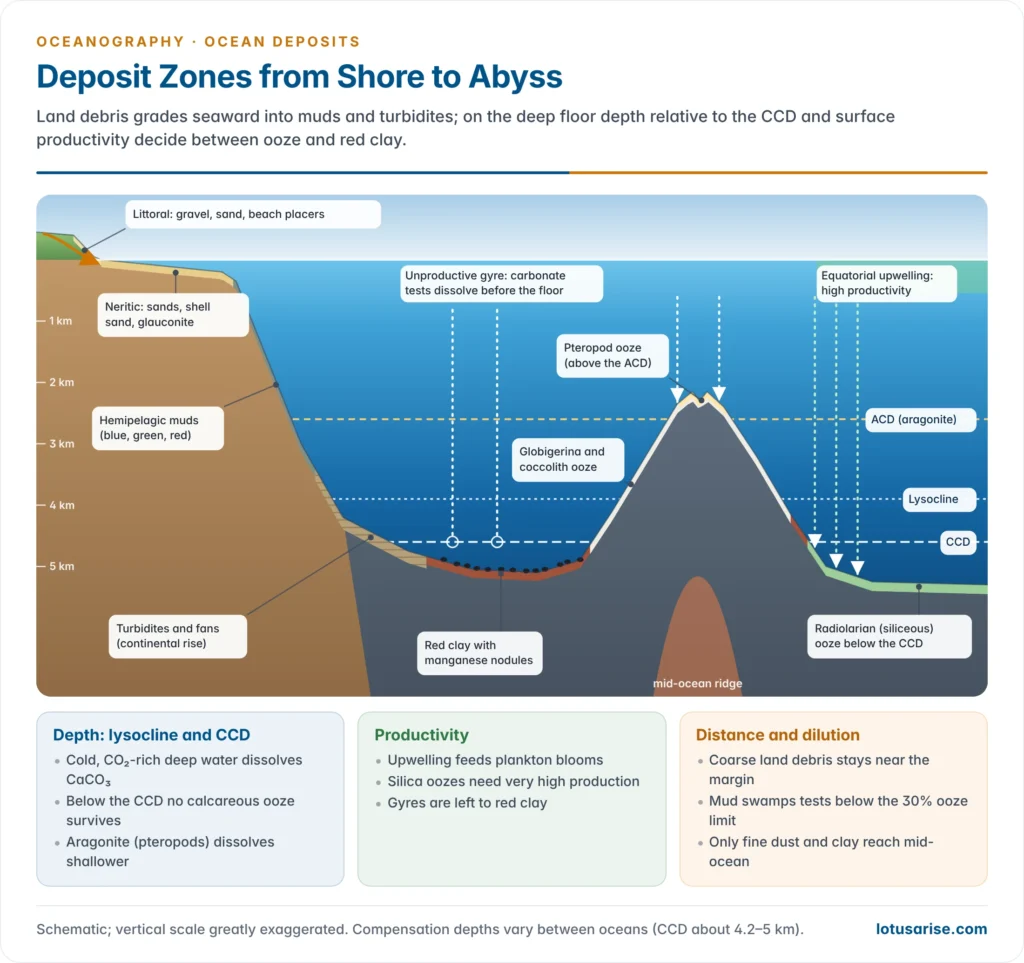
- Distance from land sets the supply of terrigenous sediment. Coarse debris stays near the margins; only fine clay and wind-blown dust reach mid-ocean.
- Depth controls carbonate, through the carbonate compensation depth (CCD):
- Cold, deep water holds more CO₂, which makes it slightly acidic. Higher pressure also raises the solubility of CaCO₃.
- The lysocline is the depth where dissolution speeds up sharply. The CCD is the depth where carbonate dissolves as fast as it arrives, so below the CCD no calcareous ooze accumulates.
- The CCD lies at about 4,200–4,500 m in the Pacific and 5,000 m or more in the Atlantic. It rises much shallower near the poles and under the most productive water.
- The aragonite compensation depth is much shallower, which is why pteropod ooze is confined to the shallowest floors.
- The CCD explains the snow-line pattern. Calcareous ooze caps ridges, rises and seamounts like snow on mountains, while the deep basins between them carry red clay or siliceous ooze.
- Sea-floor spreading adds a vertical sequence. Crust born on a ridge crest above the CCD collects carbonate. As it cools and sinks below the CCD, red clay or siliceous ooze is laid over the carbonate.
- Productivity: siliceous and calcareous oozes need high surface production. This happens under equatorial and polar upwelling and in coastal upwelling belts. The subtropical gyres are biological deserts, left to red clay.
- Dilution: near land, terrigenous sediment swamps biogenous tests below the 30% threshold. Coastal seas are productive yet floored by muds.
- Age of the floor: sediment is thin on young crust and thickens away from the ridge. This is a key support for sea-floor spreading.
- Climate belts: going poleward from the equator the floor changes from radiolarian ooze under the equatorial divergence, to red clay under the gyres, to calcareous ooze on the ridges, to diatom ooze in subpolar seas, to glacial-marine debris at the ice edge.
World distribution
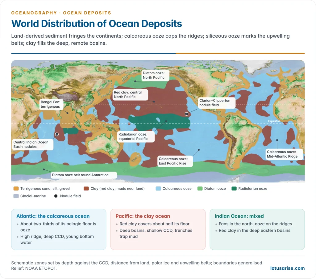
- Calcareous ooze covers about 48% of the deep-sea floor, red clay about 38% and siliceous ooze about 14%. Terrigenous deposits fringe every continent and dominate the polar seas.
- The share of each type differs between the oceans:
| Pelagic deposit (% of pelagic area) | Atlantic | Pacific | Indian |
|---|---|---|---|
| Calcareous oozes | 67.5 | 36.2 | 54.3 |
| Siliceous oozes | 6.7 | 14.7 | 20.4 |
| Red clay | 25.8 | 49.1 | 25.3 |
- The Atlantic is the calcareous ocean. Its Mid-Atlantic Ridge rises high, its CCD is deep and its bottom water is young and less corrosive.
- Red clay is confined to the deep western basins, where the CCD is shallower than in the east.
- Siliceous ooze is scarce: diatom ooze lies only in the far south, with a little radiolarian ooze near the equator.
- The Pacific is the clay ocean. It is deep, and its bottom water is the oldest and most CO₂-rich at the end of the deep circulation, so its CCD is shallow.
- Trenches round its rim trap land sediment.
- Red clay covers the central North Pacific. Calcareous ooze is restricted to the East Pacific Rise and the South Pacific. Radiolarian ooze lies along the equator and diatom ooze in the far north and south.
- Vertically, on a typical ocean slope, the sequence downward runs from pteropod ooze, to globigerina ooze, to radiolarian or diatom ooze, to red clay at the greatest depths. This was noted early by Emil Philippi.
Ocean deposits of the Indian Ocean
- Terrigenous sediment dominates the north. The Ganga–Brahmaputra builds the Bengal Fan, the largest on Earth. The Indus builds the Indus Fan in the Arabian Sea.
- Their turbidites reach south of the equator and record Himalayan uplift and monsoon erosion. Ocean drilling of the Bengal Fan in 2015 traced this record back more than 20 million years.
- Calcareous ooze covers the Carlsberg, Central and South-West Indian Ridges, the Chagos–Laccadive and Ninety East Ridges and the shallower western basins. It makes up just over half the pelagic area.
- Red clay floors the deep eastern basins below about 5,000 m, especially the Wharton Basin east of the Ninety East Ridge.
- Siliceous ooze: radiolarian ooze lies in a narrow belt south of the equator in the central and eastern basin, and diatom ooze in a broad belt round Antarctica.
- The Central Indian Ocean Basin carries rich polymetallic nodules on siliceous ooze and clay, at about 5,000 m.
- India became the first registered pioneer investor (1987). It holds an International Seabed Authority contract (2002) for 75,000 km² there, now extended to 2027.
- It added sulphide contracts on the Central and South-West Indian Ridges (2016) and the Carlsberg Ridge (2025).
- Under the Deep Ocean Mission (2021), India’s NIOT tested its Varaha nodule collector at about 5,270 m in the basin, and collected nodules at about 1,200 m in the Andaman Sea in 2024.
- The Bay of Bengal margins hold gas hydrates, and the Kerala–Tamil Nadu–Odisha coasts hold heavy-mineral placers.
Significance of ocean deposits
- Archives of past climate. Cesare Emiliani (1955) used oxygen isotopes in foraminiferal tests to reconstruct glacial–interglacial cycles, and so founded palaeoceanography. Cores now give continuous records of past climates over tens of millions of years.
- A record of ocean chemistry. The CCD rose by more than 2 km in the South Atlantic during the carbon release of the Palaeocene–Eocene Thermal Maximum (about 56 million years ago).
- Today ocean acidification is raising the saturation horizons again. A 2018 study found that human-made CO₂ is already dissolving sea-floor calcite in parts of the North Atlantic and Southern Ocean.
- Carbon storage. Burial of carbonate and organic matter removes carbon from the ocean–atmosphere system over geological time.
- Evidence for plate tectonics. Deep-sea drilling found sediment that is thinner and younger towards the ridges, and nowhere older than about 180 million years.
- Resources. Ocean deposits hold most offshore oil and gas, placers, sand and gravel, phosphorite, hydrates and the polymetallic nodules and crusts now at the centre of the deep-sea mining debate.
- Hazards. Slope failures and turbidity currents break submarine cables and can raise tsunamis.
Previous Year Questions
2015Describe the characteristics of different types of pelagic deposits.2010Write short note on Ocean deposits.2007Discuss the different bases for classifying the ocean deposits and give a detailed account of pelagic deposits of the oceans.2004Write short note: Pelagic deposits.1986Write short note on Pelagic deposits in about 200 words.




