

- The general circulation of the atmosphere is the planet-wide, time-averaged pattern of winds, at the surface and aloft, that moves heat, momentum and water vapour between the tropics and the poles.
- It exists because the Earth is heated unequally: latitudes equatorward of about 35–40° gain more radiation than they lose and those poleward of it lose more, a latitudinal heat imbalance that winds and ocean currents remove. Without it the equator would grow steadily hotter and the poles colder.
- Its shape is set by differential heating, the Earth’s rotation (Coriolis force and conservation of angular momentum), friction, and the distribution of land and sea. Much of its energy comes from the latent heat released when water evaporated from tropical oceans condenses in deep clouds.
- The surface result is the familiar system of seven alternating pressure belts and the planetary winds between them; the vertical result is the three-cell (tricellular) meridional circulation in each hemisphere.
Basis of the General Circulation

Scales of Atmospheric Motion
| Order | Scale | Examples | Size and life |
|---|---|---|---|
| Primary | Macro (planetary) | Trades, westerlies, polar easterlies, jet streams | Global; permanent |
| Secondary | Synoptic | Cyclones, anticyclones, monsoons, air masses | 1,000–5,000 km; days to a season |
| Tertiary | Meso and micro | Local winds, land and sea breezes, thunderstorms, turbulence | Under 100 km; minutes to hours |
- The primary circulation builds the framework; secondary and tertiary systems ride on it and modify it.
Energy, Rotation and Angular Momentum
- Energy: unequal heating creates potential energy (warm, light air beside cold, dense air). Rising warm air and sinking cold air turn it into kinetic energy of winds, which friction and small eddies dissipate. The circulation is maintained because generation and dissipation balance.
- Edward Lorenz (1955) formalised this as the conversion of available potential energy into kinetic energy, the basis of the modern “energy cycle” of the atmosphere.
- Rotation: the Coriolis force deflects moving air to the right in the northern hemisphere and to the left in the southern, so flow that would be meridional (north–south) becomes largely zonal (east–west).
- Angular momentum: a parcel’s angular momentum depends on its speed and its distance from the Earth’s axis. Air moving poleward comes closer to the axis and must speed up eastward, which is why the upper flow in the tropical cell turns into westerlies.
- The surface easterlies (trades) gain westerly momentum from the Earth by friction; the mid-latitude westerlies give it back. The momentum is carried poleward aloft, most strongly near the subtropical jet at about 200–250 hPa near 30° latitude.
- So the surface easterlies and westerlies must balance: a planet with only easterlies would steadily slow the Earth’s spin.
Evolution of the Models
Edmond Halley (1686): Thermal Convection
- Edmond Halley (1686) explained the trade winds and monsoons as air drawn towards the most strongly heated belt under the overhead sun, rising there and being replaced by cooler air from higher latitudes.
- Criticism: he attributed the easterly direction of the trades to the sun’s daily westward motion, not to the Earth’s rotation; the model could not explain winds outside the tropics.
George Hadley (1735): One Cell per Hemisphere
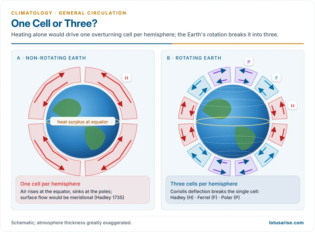
- George Hadley (1735) proposed a single, thermally driven cell in each hemisphere: air rises at the equator, flows poleward aloft, sinks at the poles and returns to the equator along the surface.
- He was the first to bring in the Earth’s rotation: returning surface air, coming from latitudes that rotate more slowly, lags behind the Earth and arrives as north-east trades in the northern hemisphere (south-east in the southern).
- Criticism:
- The surface flow would be easterly at all latitudes, but middle latitudes have westerlies.
- Air leaving the equator aloft and keeping its angular momentum would reach about 130 m/s by 30° latitude, far stronger than any observed wind; a single cell cannot survive on a rotating Earth.
William Ferrel (1856): Three Cells
- William Ferrel (1856) broke Hadley’s cell into three cells per hemisphere, adding a mid-latitude cell turning the opposite way, which explained the surface westerlies and the subtropical high at about 30°.
- He also stated Ferrel’s law: moving air is deflected to the right in the northern hemisphere and to the left in the southern.
Carl-Gustaf Rossby (1941) and Erik Palmén (1951)
- Carl-Gustaf Rossby (1941) refined the three-cell model from upper-air soundings. He held that the upper westerlies of middle latitudes receive their westerly momentum from the cells on either side, and earlier (1939) had explained the long waves in these westerlies, now called Rossby waves.
- Erik Palmén (1951), using the wartime and post-war upper-air network, drew the modern meridional section: breaks in the tropopause, the polar-front jet and subtropical jet above them, and the polar front sloping beneath.
- His key finding: outside the tropics, heat and momentum move poleward mainly through horizontal eddies (travelling cyclones, anticyclones and waves), not through a closed vertical loop.
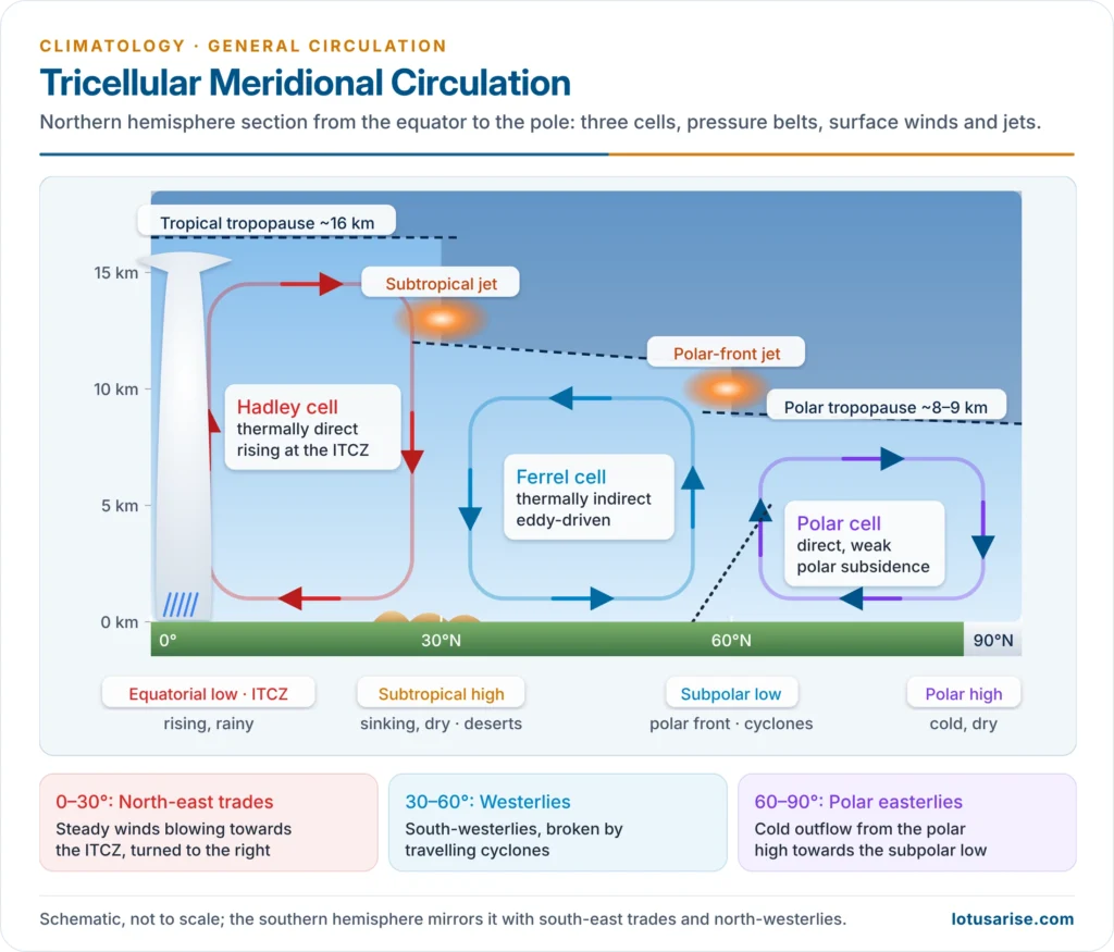
The Tricellular Meridional Circulation
Hadley Cell (Tropical Cell)
- Location and type: equator to about 30°; thermally direct (warm air rises, cold air sinks). It is the strongest and most regular of the three cells.
- Rising limb: over the equatorial trough or Inter-Tropical Convergence Zone (ITCZ), where the trades converge. Latent heat released in towering cumulonimbus clouds drives the cell; this calm, sultry belt of afternoon thunderstorms is the doldrums (roughly 5°N–5°S).
- Upper limb: air spreads poleward at about 8–15 km as the anti-trades. The Coriolis force turns it into westerlies, concentrated at the cell’s poleward edge in the subtropical jet stream (about 200 hPa).
- Upper-air data show the anti-trades are neither regular nor continuous; they are clearest over the eastern oceans and in winter.
- Sinking limb: between about 20° and 35°, for two reasons:
- radiative cooling makes the upper air dense
- the poleward flow, deflected into a near west–east current, piles up (converges) aloft
- The descending air warms adiabatically and is already dry, giving the subtropical high-pressure belt (horse latitudes) and the hot deserts: the Sahara, Arabia, the Thar, Kalahari and the Australian desert.
- Surface limb: the north-east and south-east trades, steady in direction, blowing from the subtropical highs to the ITCZ.
- Seasonal form: the annual mean shows two mirror cells, but near the solstices one strong winter-hemisphere cell crosses the equator and rises in the summer hemisphere.
- Indian example: in July the south-east trades cross the equator and, deflected to the right, arrive as the south-west monsoon; their strongest core is the low-level Somali (Findlater) jet off East Africa.
- Why it is maintained: thermal explanations stress the tropic–pole temperature contrast; dynamic ones stress the self-reinforcing instability of moist equatorial air. The two are complementary.
Ferrel Cell (Mid-Latitude Cell)
- Location and type: about 30° to 60°; thermally indirect: air sinks at the warmer subtropical edge and rises at the colder subpolar edge, the reverse of the Hadley cell.
- Surface flow: poleward from the subtropical highs, deflected into the westerlies: south-westerlies in the northern hemisphere, north-westerlies in the southern.
- They are variable, broken by travelling extratropical cyclones and anticyclones, and stronger in winter.
- Over the almost unbroken southern oceans they become the Roaring Forties, Furious Fifties and Shrieking (Screaming) Sixties.
- The upper-air puzzle: a closed indirect cell implies easterlies aloft, yet the upper flow is strongly westerly. The westerlies aloft arise from the poleward fall of temperature (the thermal wind) and are fastest in winter, when the gradient is steepest.
- Modern view: the Ferrel cell is largely a statistical average of eddies. Heat moves poleward through surges of cold polar air equatorward and warm tropical air poleward along the meanders of the westerlies. This mid-latitude exchange carries the largest share of poleward heat in the atmosphere.
- Indian example: western disturbances carried by the winter westerlies bring rabi-season rain to the north-western plains and snow to the western Himalaya.
Polar Cell
- Location and type: about 60° to the poles; thermally direct but weak and shallow.
- Cold air subsides over the poles, forming the polar highs, and flows out as the polar easterlies.
- The Antarctic high over the ice plateau is strong and persistent; the Arctic high is shallow and intermittent, and the northern polar easterlies are poorly organised.
- The easterlies meet the westerlies along the polar front in the subpolar low (about 60°), where frontal temperate cyclones form. The Aleutian and Icelandic lows are statistical averages of the cyclones that converge there.
| Cell | Latitudes | Type | Surface wind | Driver | Climate signature |
|---|---|---|---|---|---|
| Hadley | 0–30° | Direct | Trades | Latent heat at ITCZ | Equatorial rain, subtropical deserts |
| Ferrel | 30–60° | Indirect | Westerlies | Eddies of adjoining cells | Cyclonic, frontal rain |
| Polar | 60–90° | Direct, weak | Polar easterlies | Radiative cooling | Cold, dry polar highs |
The Real Circulation: Departures from the Model
Seasonal Shifting of the Belts
- Pressure and wind belts follow the overhead sun, about 5–10° of latitude, with a lag of one to two months. The shift is larger over continents, and the lag longer over oceans.
- Three transition zones fall under different belts in different seasons:
- 5–15°: ITCZ rain in summer, dry trades in winter; the savanna and tropical monsoon climates
- 30–40°, western sides of continents: dry subtropical high in summer, westerly cyclones in winter; the Mediterranean climate
- 60–70°: subpolar lows and westerly air in summer, polar outbreaks in winter
- Indian example: the ITCZ moves to about 20–25°N over the Indo-Gangetic plain in July as the monsoon trough, and retreats south of the equator in January.
Land, Sea and the Centres of Action
- Northern hemisphere (land hemisphere): continents break the belts into cells.
- July: heated continents develop thermal lows (the Asiatic low over north-west India and Pakistan), the subtropical high survives only over the oceans as the Pacific (Hawaiian) and Azores (Bermuda) highs, and onshore monsoon winds replace the trades.
- January: cold continents carry intense highs (the Siberian high, often above 1030 hPa), while the Aleutian and Icelandic lows dominate the oceans.
- The Himalaya separates the Siberian high from India, sparing the subcontinent the coldest Asian outflow.
- Southern hemisphere (water hemisphere): belts are nearly zonal and change little with season; three oceanic subtropical highs sit on the eastern sides of the oceans and an unbroken circumpolar trough rings Antarctica.
- East–west contrast in the subtropical highs:
- Eastern sides of oceans: strong subsidence, a low trade-wind inversion, cold currents, clear skies and west-coast deserts (Atacama, Namib)
- Western sides: weak subsidence, poleward flow of warm, moist air, humid and often stormy weather (south-east USA, south China)
- Centres of action: the areas of strong convergence and divergence. The ITCZ is the most continuous convergence belt; the subtropical highs are the main divergence areas. Cyclones and anticyclones move along their margins.
Meridional and Zonal Circulation
Meridional Circulation and Its Importance in World Climate
- Meridional circulation is the north–south (and vertical) exchange of air. Mean surface winds are mostly zonal, but the small meridional component does most of the work of balancing heat. Its channels are:
- the Hadley overturning in the tropics
- eddies in middle latitudes: cyclones, anticyclones, Rossby-wave meanders and cold and warm air-mass outbreaks
- monsoons, seasonal meridional flows across the equator
- Importance:
- Heat balance: carries the tropical surplus poleward, keeping the equator from overheating and the poles from freezing further
- Moisture and rain belts: rising branches give the equatorial and mid-latitude frontal rain belts; sinking branches give the subtropical deserts
- Climatic zones: the belts and their seasonal shifts underlie the world’s climatic regions and the Köppen pattern
- Ocean circulation: the trades and westerlies drive the subtropical gyres and the upwelling off west coasts
- Weather systems: steers tropical cyclones and the mid-latitude storm tracks
- Mixing: spreads water vapour, aerosols, ozone and pollutants round the globe; together these make the Earth habitable over a far wider band than radiation alone would allow
Zonal Circulation and the Walker Circulation
- Zonal circulation is the east–west component: the trades, westerlies and polar easterlies, and the east–west overturning cells along the equator.
- Zonal index: the strength of the westerlies between about 35° and 55°. A high index means straight, fast westerlies with little meridional exchange; a low index means deep meanders and strong exchange (the index cycle of the jet streams).
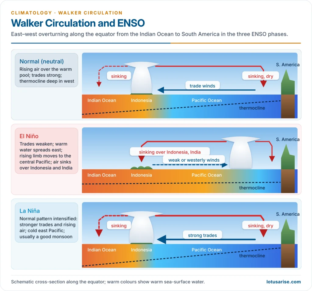
- Walker circulation: an east–west cell over the equatorial Pacific, linked to the Southern Oscillation found by Gilbert Walker in the 1920s and named after him by Jacob Bjerknes (1969).
- Normal years: air rises over the warm pool of Indonesia and the western Pacific, flows east aloft, sinks over the cold eastern Pacific off Peru, and returns west as the trades, which pile warm water in the west.
- El Niño: the trades weaken, warm water spreads east, and the rising limb shifts to the central and eastern Pacific; air sinks over Indonesia, Australia and the Indian region.
- La Niña: the normal pattern intensifies.
- The Southern Oscillation Index (pressure difference, Tahiti minus Darwin) tracks the see-saw: negative in El Niño, positive in La Niña.
- Indian example: El Niño years weaken the Indian monsoon through subsidence over the subcontinent: 2002, 2009, 2015 and 2023 were El Niño years with below-normal rain, and the 2026 monsoon, under a developing El Niño, ended at about 87% of the long-period average, the lowest since 2015.
- The Indian Ocean Dipole, a similar east–west mode of the Indian Ocean, can offset El Niño, as in 1997 and 2019.
Rossby Waves in the Upper Westerlies
- Above the Ferrel cell the westerlies form three to six long waves around each hemisphere, each several thousand kilometres long, with ridges (warm air, high pressure) and troughs (cold air, low pressure).
- They arise because the Coriolis effect increases with latitude: a parcel displaced poleward is turned back equatorward, and vice versa, so the flow oscillates about its mean latitude.
- Large meanders cut off pools of cold air (cold lows) and warm air (blocking highs), exchanging heat between latitudes; when they stall, weather persists for days or weeks.
The Modern View
From Cells to Eddies and Models
- The three cells are a zonal average. Only the Hadley cell is a real, persistent overturning; in middle latitudes the eddies are the circulation, and the Ferrel cell is their statistical footprint.
- The atmosphere and the oceans share the poleward heat load: the oceans carry much of it in the low latitudes, the atmosphere most of it beyond about 30°.
- Since Norman Phillips (1956) built the first numerical general circulation model, the circulation has been studied with coupled ocean–atmosphere models. India’s Monsoon Mission (2012), led by the Indian Institute of Tropical Meteorology, Pune, uses one for seasonal monsoon forecasts.
Widening of the Tropics
- The IPCC Sixth Assessment Report (2021) finds the Hadley circulation has likely widened since the 1980s, mostly in the northern hemisphere, with only medium confidence in how much; estimates range around 0.1–0.5° of latitude per decade.
- Human influence (greenhouse gases and ozone depletion) has likely contributed to the southern hemisphere widening.
- Consequences: the subtropical dry belts, storm tracks and jets edge poleward, adding to drying in the Mediterranean, south-western Australia, southern Africa and central Chile.
- Arctic amplification (the Arctic has warmed nearly four times as fast as the globe since 1979) weakens the pole–equator temperature contrast. Whether this makes the jet wavier and weather more persistent remains debated.
Previous Year Questions
2025Examine the formation of atmospheric tricellular circulation system. Describe how this system has been created considering the Earth a living planet.2019Discuss in detail the tri-cellular model of atmospheric circulation.2015Explain the meridional circulation of the atmosphere and its importance in world climate.2003Discuss the mechanism and significance of tricellular meridional circulation of atmosphere.




