

- Urban sprawl is the unplanned, low-density and scattered outward spread of a city into the surrounding countryside. It pays little regard to land efficiency, infrastructure or the environment.
- All growing cities expand. Sprawl is the form of expansion in which built-up land grows faster than population, so density falls, and development leaps, strings out along roads and scatters instead of growing compactly.
- In India, sprawl appears as peri-urbanisation: villages, census towns, colonies, townships and industrial estates spreading beyond municipal limits into the rural–urban fringe.
Concept of Urban Sprawl

Meaning
- Sprawl is often called horizontal spreading or dispersed urbanisation, in contrast to compact, vertical growth.
- Reid Ewing (1997) identified sprawl by its forms (leapfrog, strip and low-density single-use development) and by its effect: poor accessibility between homes, jobs and services.
- George Galster and colleagues (2001) measured it on eight dimensions. Low values of each indicate sprawl:
- density, continuity, concentration, clustering, centrality, nuclearity, mixed uses and proximity.
- Sprawl is mainly a land-use problem: a mismatch between spatial expansion and population growth, worsened by weak zoning and speculative real estate.
- Attempts to capture it in a single compactness index have often failed, because sprawl has many dimensions.
- Related terms:
- Suburbanisation: planned residential growth outside the city, dependent on it.
- Peri-urbanisation: mixed rural–urban growth in the zone around the city.
- Exurbanisation: urban people living in rural areas beyond the suburbs.
- Edge cities: office and retail clusters at highway junctions.
- The World Bank (2016) described South Asia’s urbanisation as “messy and hidden“. Much of it lies in sprawling peripheries and census towns outside official city limits.
Characteristics
- Excessive land consumption:
- Much land is used for a small rise in population.
- Farmland, forests, wetlands and open space are converted rapidly.
- Low density at the periphery, compared with the compact old core. This makes services costly.
- Fragmented, discontinuous development:
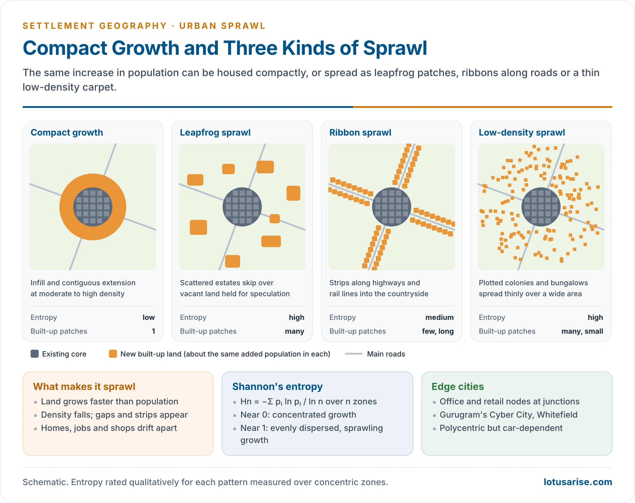
- Leapfrog growth, gaps of vacant land between built-up patches, and isolated colonies and townships.
- Ribbon development along highways and arterial roads.
- Functional segregation of land uses: homes, shops, offices and factories lie far apart, so daily travel increases.
- Dependence on private vehicles, because public transport is thin and walking is impractical.
- Uniform, repetitive built forms: plotted colonies, single-use townships and malls ringed by parking.
- Few public spaces and weak neighbourhood life.
- Infrastructure lagging behind growth: water, sewerage, drainage and roads arrive years after houses.
Forms of Sprawl
| Form | Pattern | Typical cause | Indian example |
|---|---|---|---|
| Leapfrog (scattered) | Patches separated by vacant land | Cheap distant land, speculation | Townships beyond Gurugram and Greater Noida |
| Ribbon (linear) | Strips along highways and rail lines | Accessibility of the road frontage | NH-48 Delhi–Jaipur, Pune–Mumbai corridor |
| Low-density continuous | Plotted colonies at the edge | Single-family housing, weak density rules | Outer Bengaluru, Hyderabad |
| Polycentric (edge cities) | Office and retail nodes at junctions | Firms leaving the core | Cyber City, Whitefield, HITEC City |
| Large-scale projects | Big planned estates set down beside the built-up area | State or developer land assembly | New Town (Rajarhat), Greater Noida |
- Compact growth is the opposite: infill and contiguous extension at moderate to high density, served by transit.
Developed and Developing Countries
- Developed countries:
- Sprawl is largely choice-driven: high incomes, car ownership, a preference for suburban homes, and mortgage and highway policies.
- The classic case is the US suburb.
- Developing countries:
- Sprawl is largely necessity-driven: rural–urban migration, housing shortages, high land prices in the core, and informal settlements beyond city limits.
- Gated townships for the middle class are added on top.
- The causes differ, but the outcomes are alike: low density, fragmentation and stressed infrastructure.
Debates on Sprawl
- Critics (Ewing and the smart-growth movement) see sprawl as environmentally damaging, socially exclusive and fiscally wasteful.
- Defenders (Peter Gordon and Harry Richardson, 1997) argue:
- Low-density growth reflects consumer preference and offers cheaper, larger housing.
- Dispersal of jobs can shorten commutes, and compact-city policies raise housing prices.
- Global evidence:
- Studies of hundreds of cities led by Shlomo Angel show that built-up densities have been falling for decades almost everywhere as cities expand.
- The policy question is therefore how to make room for expansion in an orderly way, not whether to stop it.
- Density contrast: around 1990, Atlanta had about 2.5 million people and Barcelona about 2.8 million. Atlanta’s built-up area was about 4,280 km² and Barcelona’s about 162 km², more than twenty-five times smaller. The difference in transport energy, infrastructure cost and car dependence follows from that contrast.
- Planning thought increasingly treats sprawl as a policy-induced outcome: of land, transport and housing-finance rules, not of population growth alone.
How Cities Expand: Diffusion and Coalescence
- Studies of long built-up records (Charles Dietzel and colleagues, 2005) show urban growth moving in alternating phases:
- Diffusion: new, scattered patches appear at the edge and along roads. Patch numbers rise, and entropy rises. This is the sprawl phase.
- Coalescence: the gaps fill in and the patches merge into a continuous built-up mass. Patch numbers fall, and the edge becomes compact again.
- Each new transport link or wave of investment starts a fresh diffusion phase farther out. Indian metros now show coalescence near the core and diffusion in the peri-urban belt.
- The suburban sequence:
- Suburbs first run as ribbons along the main roads into a town.
- Demand then fills the land between them, with new roads, as infill.
- Towns and villages within commuting range turn residential.
- Neighbouring suburbs may close up into a continuous belt, a conurbation.
- Classical models of outward growth:
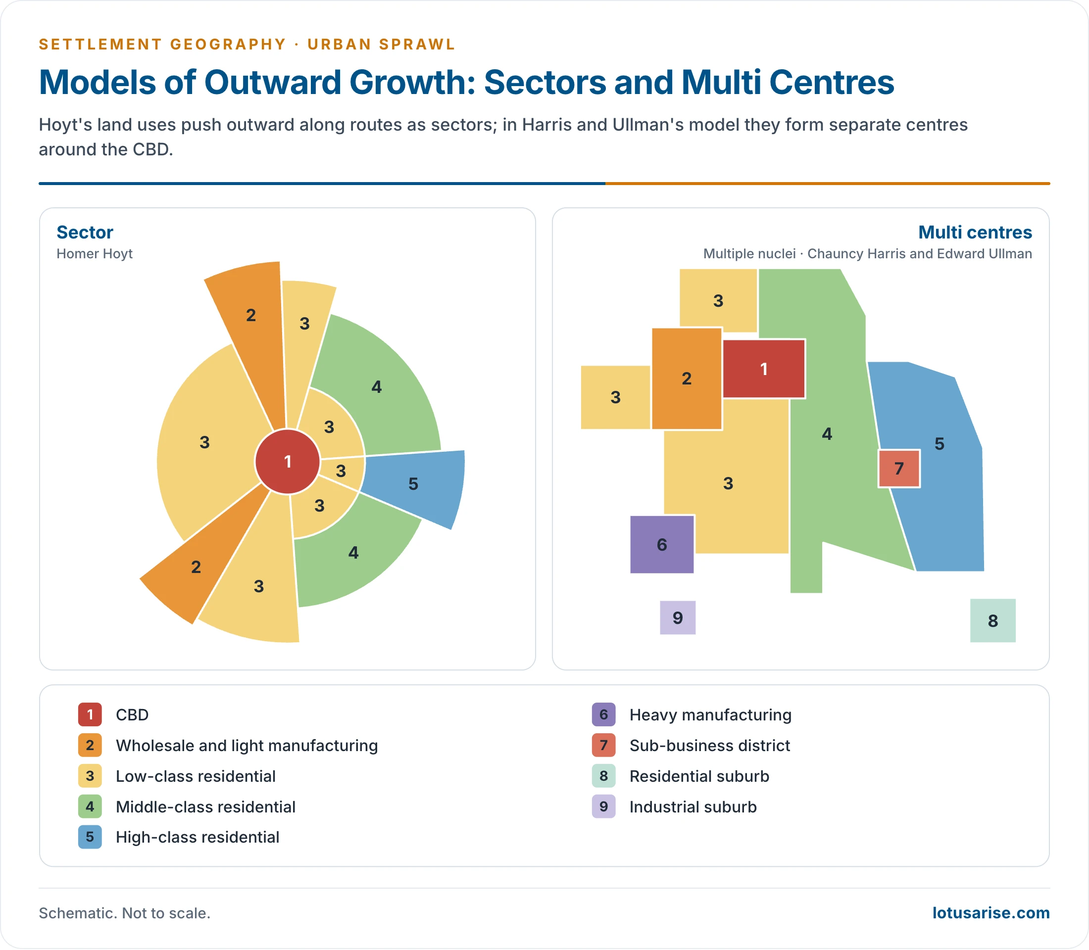
- Homer Hoyt’s sectors: wholesale and light industry and each class of housing push outward along routes.
- Chauncy Harris and Edward Ullman’s multiple nuclei: heavy industry, a sub-business district, and residential and industrial suburbs form separate centres around the CBD.
- Both are set out in the theories of urban morphology.
Measuring Sprawl
- Built-up area change:
- Satellite images (Landsat since 1972, now Sentinel) map built-up and impervious surfaces over decades.
- The rate of growth of built-up land is compared with the rate of population growth.
- SDG indicator 11.3.1: the ratio of land consumption rate to population growth rate. A ratio above 1 means land is being urbanised faster than people are being added.
- Density and its gradient: gross and net density, and how fast density falls with distance from the centre.
- Shannon’s entropy:
- Hn = −Σ pi ln(pi) / ln(n), where pi is the share of the total built-up area found in zone i (concentric rings or sectors), and n is the number of zones.
- Values near 0 mean compact, concentrated growth. Values near 1 mean built-up land is evenly dispersed, a sign of sprawl.
- It was popularised for sprawl by Anthony Yeh and Xia Li (2001).
- Landscape metrics: the number and density of built-up patches, the largest-patch index and edge density. A rising number of small patches signals leapfrogging.
- Night-time lights, land-price gradients and commuting data add economic and functional views.
Bengaluru: Measured Sprawl
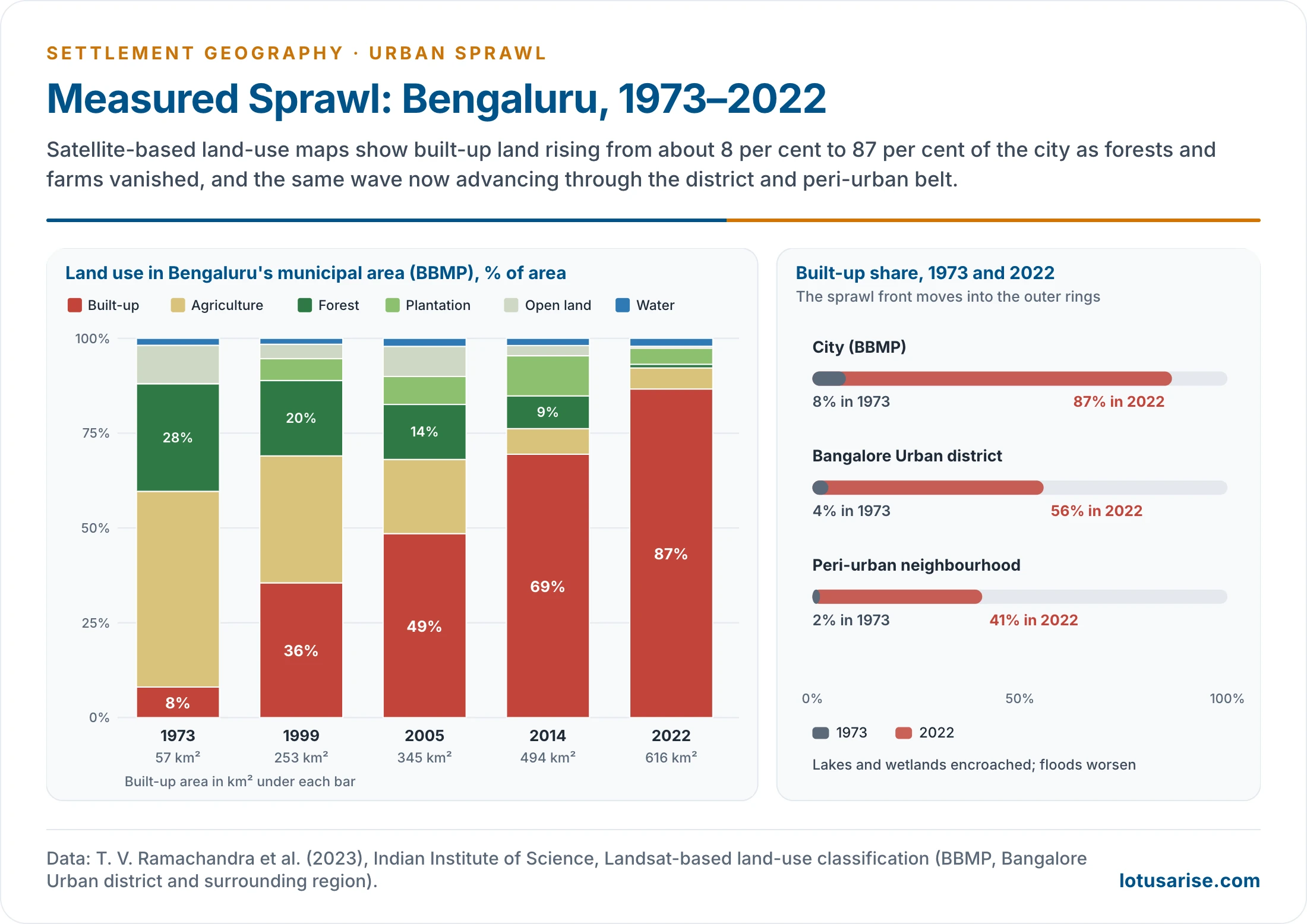
- Landsat-based studies at the Indian Institute of Science show that the built-up share of the city area (BBMP) rose from about 8% in 1973 to about 87% in 2022.
- Built-up land grew from about 57 km² to 616 km².
- Forest cover fell from 28% to under 1% and farmland from 52% to under 6%.
- The wave has moved outward:
- the built-up share of the wider Bangalore Urban district rose from about 4% to 56%;
- in the surrounding peri-urban belt, from about 2% to 41%.
- Growth followed industrial and IT corridors (Whitefield, Electronic City, the Outer Ring Road) and the airport road. Lakes and wetlands were encroached, which worsened floods.
Causes of Urban Sprawl
- Population growth and migration:
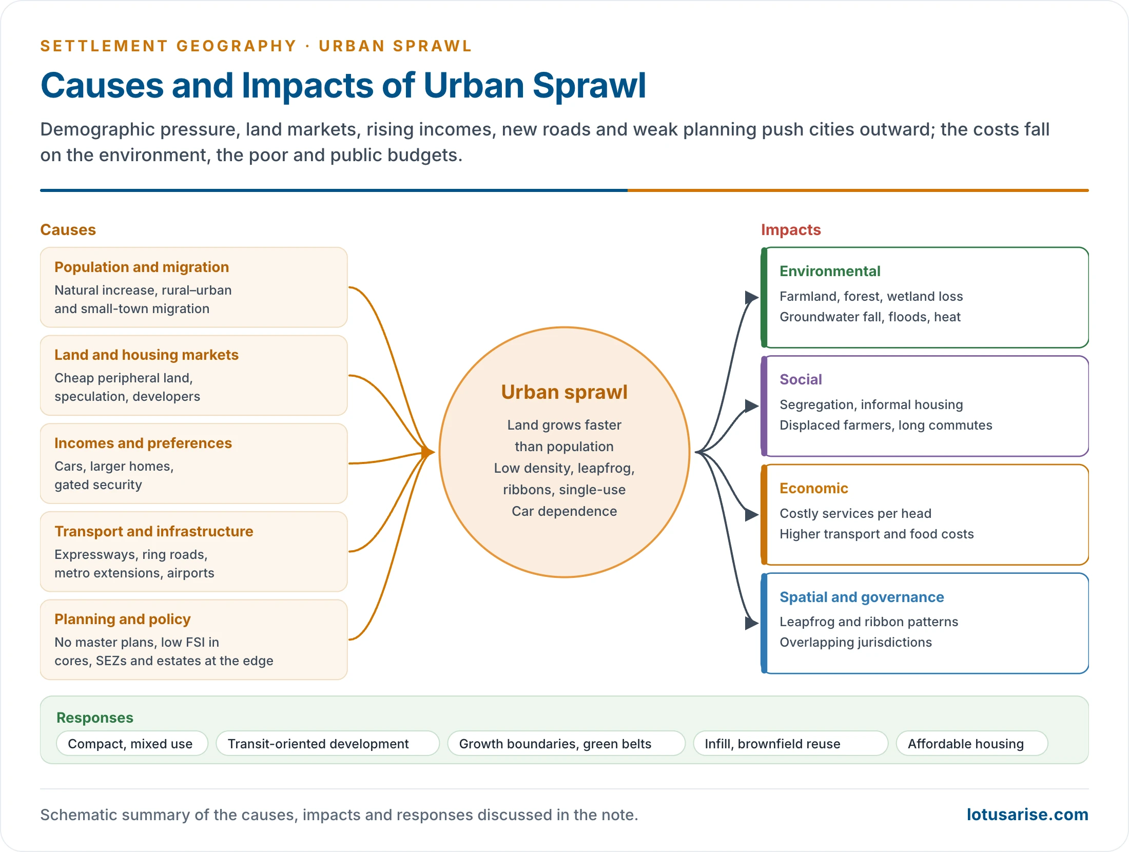
- Natural increase, rural–urban migration and movement from small towns to large cities press on the existing city.
- Their weight varies by city and period, but in most cities rural–urban migration matters most.
- Migration waves: the depression of the late 1930s sent people to towns for work; wartime industry and Partition moved many more in 1941–51; well over 20 million moved to cities in 1991–2001.
- Large cities act as magnets for migrants, which is called hyperurbanisation.
- Migrants crowd first into the old city, near relatives and work. John E. Brush (1968) called this central concentration urban impulsion. Density falls sharply beyond the old city.
- Growth spills into peri-urban areas.
- India’s urban population rose from 286 million in 2001 to 377 million in 2011 (Census).
- Cheaper land and housing at the periphery:
- Core land prices, overcrowding and pollution push households and firms outward.
- Developers prefer cheap peripheral land with fewer controls.
- Rising incomes and changing preferences:
- Larger homes, private open space, gated security and car ownership make longer commutes acceptable.
- This cause dominates in developed countries.
- Transport and infrastructure:
- Highways, expressways, ring roads, flyovers and metro extensions open distant land and create ribbon growth and edge nodes.
- Water, power and telecom lines reduce the cost of living far away.
- Weak planning and governance:
- Many towns have no current master plan, and enforcement is weak. A NITI Aayog report (2021) found that about 65% of India’s 7,933 urban settlements had no master plan.
- Planning powers are split between municipalities, development authorities and panchayats.
- Census towns grow without urban local bodies.
- Land markets and conversion:
- Speculation holds land vacant, so building leapfrogs beyond it.
- Farmland and commons are converted for higher returns. The falling share of land held by farmers shows urban use overtaking rural use.
- Regulations that push growth outward:
- Low floor-space limits in cores, rent control and slow redevelopment keep central densities low.
- Growth is forced to the edge.
- Government projects at the edge:
- SEZs, industrial estates, IT parks, airports and new townships attract population.
- Road-centred policies deepen car dependence.
- Technology: cars, telecommunications and remote work loosen the link between home and workplace.
- Cellular automata and agent-based models, run on GIS and remote-sensing data, show transport networks, population growth and policy choices jointly driving outward expansion.
How Transport Investment Drives Sprawl in India
- Ring roads and expressways:
- The Dwarka Expressway in Gurugram, the Yamuna Expressway towards Greater Noida, and Bengaluru’s Outer and Peripheral Ring Roads turned farmland along them into townships, warehouses and IT campuses.
- Metro extensions (Delhi to Gurugram, Noida, Faridabad and Ghaziabad; Bengaluru to Whitefield) raise land values at outer stations. Unless density is planned around stations, they extend the commuting city outward.
- Airports (Bengaluru’s Devanahalli, Hyderabad’s Shamshabad) pull growth along their access corridors.
- Freight and industrial corridors create linear industrial and logistic sprawl.
Sprawl in Other Indian Metros
- Hyderabad: the 158-km Outer Ring Road and the airport at Shamshabad drew IT campuses, gated communities and logistics parks to the west and south. HITEC City, Gachibowli and the Financial District became an edge city.
- Chennai: growth ran along the IT Corridor (Old Mahabalipuram Road), GST Road and the western highways. The Pallikaranai marsh and other wetlands shrank under building and dumping, which worsened the floods of 2015.
- Mumbai Metropolitan Region: hemmed in by the sea, growth leapt across the creeks. Thane, Kalyan–Dombivli, Vasai–Virar, Navi Mumbai and Panvel grew along the suburban rail lines, the harbour links and the new airport.
- Kolkata: planned townships at Salt Lake and New Town (Rajarhat) spread eastward onto wetlands and farmland, while older growth followed the river and rail lines.
- Smaller cities (Pune, Ahmedabad, Jaipur, Lucknow) show the same ribbon growth along bypasses and ring roads, with plotted colonies far ahead of water and sewer lines.
Peri-Urbanisation in the National Capital Region
- Causes:
- Delhi’s land and housing costs and its planned limits pushed people and firms to Gurugram, Noida, Greater Noida, Ghaziabad, Faridabad and Sonipat.
- Private townships, expressways, the metro and IT-led office growth (Cyber City, Noida’s sectors) made these areas attractive.
- Land acquisition and change-of-land-use licensing converted farmland quickly. Services did not keep pace.
- Environmental consequences:
- Groundwater: large parts of Gurugram and Faridabad depend on borewells, and water tables have fallen steeply.
- The Aravallis and natural drains have been quarried and built over, which reduces recharge and causes waterlogging after heavy rain.
- The Yamuna floodplain and the Najafgarh drain basin are encroached and polluted by untreated sewage.
- Air pollution comes from construction dust, diesel generators, brick kilns and traffic on long commutes.
- Waste: landfills such as Ghazipur (Delhi) and Bandhwari (Gurugram) have grown into hills of garbage that leach into soil and water.
- Loss of farmland and green cover deepens the urban heat island.
- Responses:
- The NCR Regional Plan proposes counter-magnet towns and protection of natural conservation zones.
- The Delhi Metro has been extended to the satellite towns.
- Courts have restricted mining in the Aravallis.
Sprawl Around Planned Cities
- Even planned cities sprawl when their plans ignore the poor and cap growth inside fixed limits:
- Chandigarh’s controlled sectors pushed growth into Mohali, Panchkula, Zirakpur and labour colonies at the edge.
- Planned steel towns developed unplanned bastis outside the company townships.
- Such outgrowths and squatter settlements have advantages and disadvantages:
- Advantages: they provide affordable housing and labour to the city and keep migrants close to work.
- Disadvantages: insecure tenure, no services, health hazards and later costly regularisation.
Impacts of Urban Sprawl
Environmental Impacts
- Loss of fertile farmland, which threatens local food supply, food security and farm livelihoods, and can raise dependence on food imports.
- Loss of forests, wetlands and green cover, with less carbon storage and habitat fragmentation. This means lost biodiversity, displaced wildlife, weaker pollination and natural pest control, and more invasive species and diseases.
- Groundwater depletion from private borewells in unserved peripheries, and pollution of rivers and lakes by untreated sewage and industrial effluent.
- Air pollution from more and longer vehicle trips: particulate matter, nitrogen oxides and volatile organic compounds.
- Urban heat islands, as concrete replaces soil and vegetation. Energy demand for cooling and heat stress rise.
- Flooding, as built-up land covers lakes, drains and floodplains: Chennai in 2015, Bengaluru in 2022.
- Unmanaged solid waste in peri-urban areas, where dumps and open burning pollute land, water and air.
Social Impacts
- Housing exclusion:
- Rising core prices push the poor to the edge, into informal settlements.
- Gated enclaves cater to the rich. The result is socio-spatial segregation. This deepens inequality and limits upward mobility.
- Unequal access to water, sanitation, health, schools and transport in the periphery.
- Unemployment and crime: many migrants do not find suitable work, and joblessness among the young feeds theft and violent crime.
- Displacement of farmers and peri-urban residents, with loss of livelihoods and social networks.
- Long commutes, little public space and weak neighbourhood ties breed isolation and stress.
- Health effects: sedentary lifestyles, air pollution, poor sanitation and few recreational spaces, which bring obesity, lifestyle diseases and stress.
Economic Impacts
- Higher per-head cost of infrastructure and services, since roads, pipes, power lines and schools must stretch over larger areas at low density. This strains urban local bodies.
- Higher household transport costs in fuel, vehicles and lost time. The poor, pushed farthest out, spend the largest share of income and time on travel.
- Steep rises in land prices as migrants and developers crowd in, which put housing beyond people of moderate income.
- Loss of farm output near cities and higher food prices.
- Disruption of small and informal enterprises by malls and redevelopment.
- Hidden costs: health spending, climate adaptation and lost ecosystem services.
- Positive side: some planners see sprawl as a sign of economic vitality. It brings more housing choice, decentralised jobs that ease core congestion, and larger homes with private open space. It also gives livelihood and shelter to lakhs of people. Without planning, however, the long-run costs usually outweigh these gains, especially in developing countries.
Spatial and Governance Impacts
- Inefficient land use: leapfrog and ribbon patterns undermine compact planning and public transport.
- Vacant plots held for speculation sit between built-up patches, so roads and pipes must cross empty land.
- Weak governance: growth outpaces planning capacity, and overlapping jurisdictions between municipalities, development authorities and panchayats leave peripheries unmanaged.
Managing Sprawl
- Integrated land-use and transport planning at the scale of the metropolitan region: regional plans, metropolitan planning committees and master plans updated on time.
- Compact, mixed-use development: higher densities and mixed uses, so that walking, cycling and transit work.
- Shops, schools and jobs close to homes cut trip lengths and make services cheaper to deliver.
- Transit-oriented development (TOD):
- Dense, mixed-use growth within walking distance of stations, under the National TOD Policy (2017).
- Examples include TOD zones along the Pune and Delhi metros.
- Public transport: metro, suburban rail, BRTS and buses that make central living convenient. Affordable networks also widen mobility and inclusion for low-income people.
- Regulation and incentives: green building norms, environmental impact assessments and incentive-based policies that reward sustainable practices and discourage sprawl.
- Containment tools: urban growth boundaries, green belts, protection of wetlands, farmland and forests, and land-use controls.
- Green areas store carbon, cool the city and support biodiversity. Farmland near cities protects food security and local livelihoods.
- Portland, Oregon has held an urban growth boundary since 1979. London’s Metropolitan Green Belt dates from 1938, and Seoul’s green belt from 1971.
- Containment works only if enough land is released inside the boundary. Otherwise housing prices rise and growth jumps beyond the belt.
- Brownfield and infill redevelopment:
- Reuse of mill lands, railway land and underused central plots before greenfield expansion.
- Revitalisation of old cores, which also preserves cultural heritage and stimulates the local economy.
- Affordable housing and slum upgrading within the city (PMAY-Urban, in-situ redevelopment), so the poor are not pushed to the edge.
- Rental housing near jobs (affordable rental housing complexes) reduces the need for migrants to settle on the far periphery.
- Land pooling and town planning schemes, in place of piecemeal conversion.
- Smart growth with GIS and remote-sensing monitoring of built-up change.
- Participatory planning with residents and local bodies. Local knowledge improves plans, and ownership improves compliance.
- Monitoring and adaptive management: regular tracking of land use, density, transport and environmental indicators allows plans to be corrected in time.
- Indian cases:
- Ahmedabad: the Sabarmati Riverfront.
- It reclaimed a neglected, encroached riverbank as public space, with promenades, parks and cultural spaces.
- It integrates rainwater harvesting, wastewater treatment and solar energy.
- Families living on the riverbank were resettled elsewhere in the city.
- By making the core more liveable, inner-city renewal reduces the pull of the periphery.
- Chennai: the Mass Rapid Transit System.
- An elevated suburban rail line connects peripheral areas to the core.
- It offers an alternative to private vehicles, reduces congestion and emissions, and supports transit-based growth along its stations.
- Surat: slum upgrading and affordable housing.
- Basic services (water, sanitation, electricity) were upgraded and affordable dwelling units built within the city.
- Housing the poor inside the city reduces informal growth at the edge and social segregation. It also strengthened community participation.
- Pune: transit-oriented development.
- High-density, mixed-use development is promoted around metro corridors, with land use integrated with transport.
- It aims to cut car dependence and commuting distances, and to improve public spaces.
- Ahmedabad: the Sabarmati Riverfront.
- Together these cases show that sprawl can be managed through land-use, transport, housing and renewal choices.
Previous Year Questions
2009“There is no sharp divide where an urban-settlements stops and rural area begins.” Analyse the statement with reference to the sprawl of Indian cities.2014How has an inappropriate urban land use policy accounted for undesirable development in and around metropolitan cities?2018Peri-urbanization has created enormous environmental problems. Discuss their causes and consequences with reference to the National Capital Region (N.C.R) of India.2020Urban sprawl around planned cities evolves leading to the emergence of squatter settlements. Discuss the advantages and disadvantages of such outgrowth.2022What are the drivers of urban sprawl around the major cities of the country? How have new investments in transport projects supported sprawl development?2023Explain the problems and prospects of urban expansion in the context of urban fringe in developed and developing nations.





Good 😊👍