

- A climatic region is a large area with a broadly uniform combination of temperature, precipitation and seasonal rhythm, and so with a characteristic natural vegetation, soil and way of life.
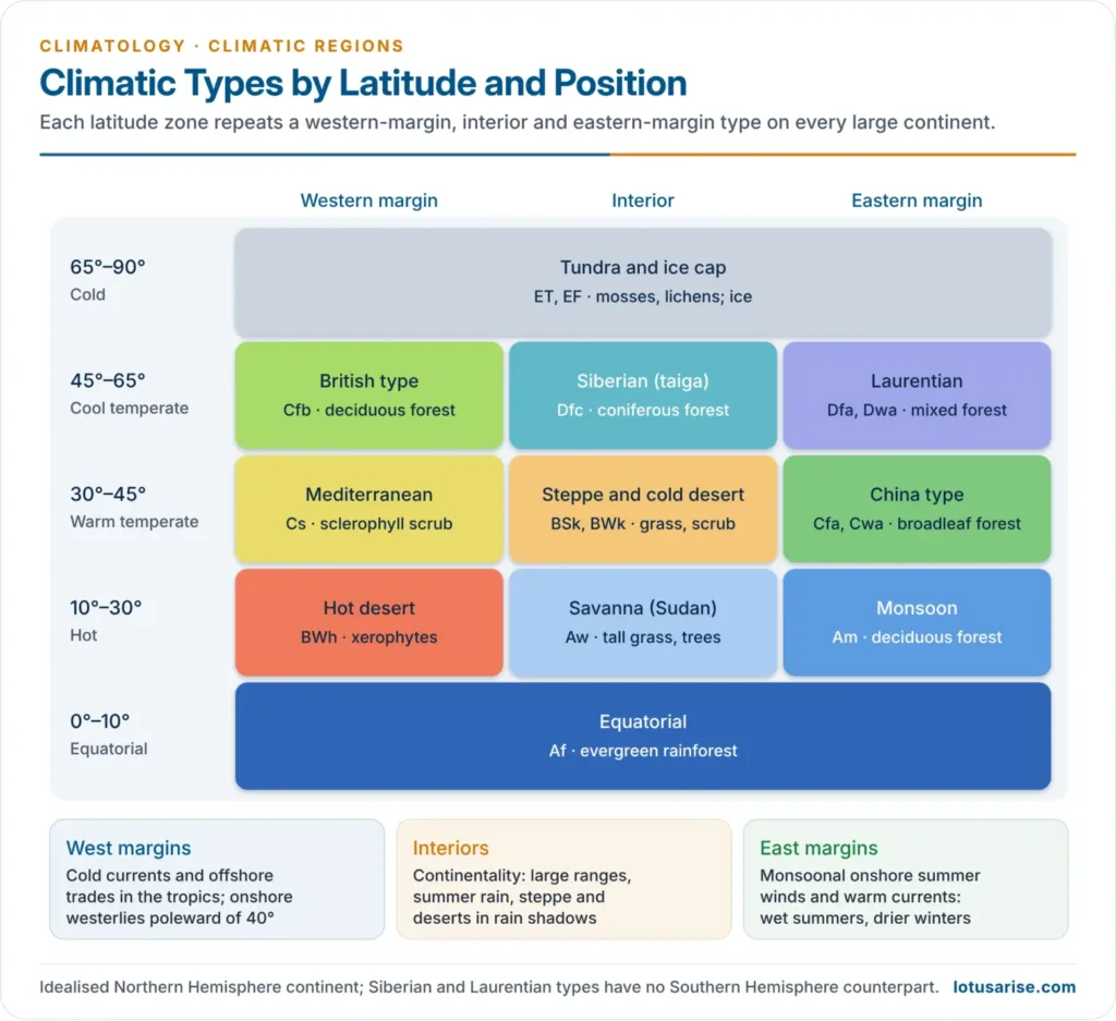
- World climatic types repeat in a regular pattern set by latitude and by position on a continent: western margin, interior or eastern margin.
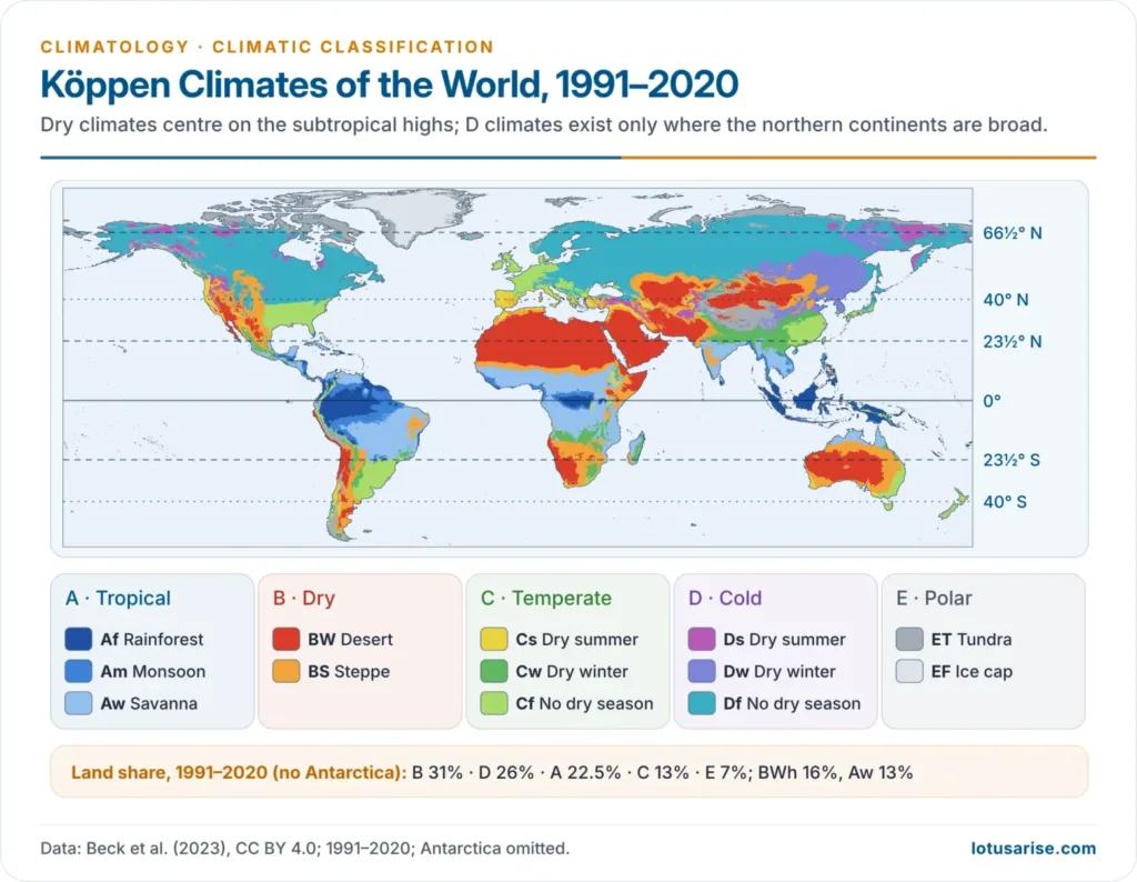
- The classical regional names (equatorial, Sudan, Mediterranean, China, British, Siberian, Laurentian) carry the codes of the Köppen classification; the Trewartha classification describes the same types through their controlling air masses.
Why Climates Fall into Regions
- Latitude fixes insolation and the temperature belts: winterless tropics, seasonal mid-latitudes, summerless poles.
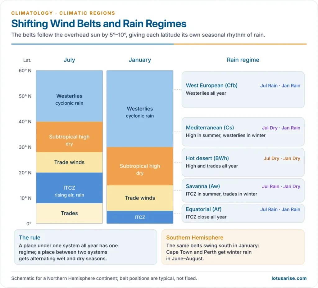
- Pressure and wind belts fix the source of rain, and their seasonal migration of about 5°–10° with the overhead sun creates wet and dry seasons.
- ITCZ brings convectional rain; subtropical highs bring subsidence and drought; westerlies bring cyclonic rain.
- A belt that sits under one system all year is uniformly wet or dry; a belt that lies between two systems gets a seasonal regime.
- Continental position:
- West margins in the trades are dry (offshore winds, cold currents); in the westerlies they are mild and wet.
- Interiors are continental: large ranges, low and summer-concentrated rain.
- East margins are monsoonal, with warm currents and onshore summer winds.
- Relief adds rain shadows and highland climates.
Overview of World Climatic Types
| Zone | Type (Köppen) | Latitude | Position | Rain regime | Vegetation |
|---|---|---|---|---|---|
| Equatorial | Equatorial (Af) | 0°–10° | All | All year, double peak | Rainforest |
| Hot | Monsoon (Am) | 10°–25° | East and south | Summer, very heavy | Monsoon forest |
| Hot | Savanna / Sudan (Aw) | 5°–20° | Interior | Summer | Tall grass, scattered trees |
| Hot | Hot desert (BWh) | 15°–30° | West and interior | Scanty, erratic | Xerophytes |
| Warm temperate | Mediterranean (Cs) | 30°–45° | West | Winter | Sclerophyll scrub, woodland |
| Warm temperate | Steppe (BSk) | 35°–55° | Interior | Light, early summer | Short grass |
| Warm temperate | China / Gulf / Natal (Cfa, Cwa) | 25°–40° | East | Summer maximum | Broadleaf, mixed forest |
| Cool temperate | British (Cfb) | 45°–60° | West | All year, autumn–winter maximum | Deciduous forest |
| Cool temperate | Siberian / Taiga (Dfc, Dfd, Dwc) | 50°–70° N | Interior | Light, summer | Coniferous forest |
| Cool temperate | Laurentian (Dfa, Dfb, Dwa, Dwb) | 40°–55° N | East | All year, summer maximum | Mixed forest |
| Cold | Tundra and ice cap (ET, EF) | Beyond 65° | All | Very light, snow | Mosses, lichens / none |
| Any | Highland (H) | Mountains | All | Varies with altitude | Altitudinal zones |
Tropical Climates
Equatorial Climate (Af)
Distribution
- 5°–10° on either side of the equator, wider on the windward eastern margins of continents.
- Amazon basin, Congo basin and Guinea coast, Malaysia, Indonesia and the Philippines, eastern Central America, coastal eastern Brazil and eastern Madagascar.
- Bordered poleward by savanna and, on eastern margins, by China-type climate.
- Highland exceptions such as the Cameron Highlands of Malaysia and the East African plateaus are cooler for their latitude.
Climate
- Uniform heat: monthly means of about 26°–28°C; annual range only 1°–3°C.
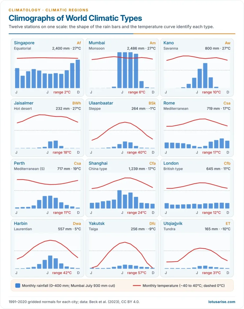
- Singapore: coldest month about 26°C, warmest about 28°C on 1991–2020 normals.
- Diurnal range (6°–12°C) exceeds the annual range, so night is the winter of the tropics.
- No winter; day and night are nearly equal all year.
- Rain is heavy (150–250 cm or more), reliable and well distributed, with double maxima after the equinoxes when the sun is overhead.
- Convectional afternoon showers from towering cumulonimbus, often with thunder; skies clear by night.
- The ITCZ and the doldrums keep winds light and air humid and unstable.
- Humidity and cloud (about 60% cover) make the heat oppressive.
Natural Vegetation
- Tropical evergreen rainforest, called selvas in the Amazon.
- Layered canopy: emergents, a closed canopy and an understorey; little light reaches the floor.
- Lianas and epiphytes abound; buttress roots support tall trees.
- Hardwoods such as mahogany, ebony, rosewood and greenheart.
- Mixed stands: hundreds of species in a small area, which makes commercial logging difficult.
- Richest biome on land, holding more species than all other biomes combined.
- Animals live mostly in the canopy: monkeys, birds, bats and insects; okapi, gorilla and jaguar on and near the forest floor.
Life and Economy
- Sparse population in the interior: hunting, gathering and shifting cultivation (jhum-like systems).
- Plantations on cleared land: rubber, oil palm, cocoa, bananas and coconut.
- Deforestation for cattle, soy and oil palm now drives the economy of the Amazon and Indonesian rainforests.
- Current issue: the 2023–24 Amazon drought and repeated clearing raise concern that parts of the forest could shift towards savanna.
- India has no true equatorial climate, but the southern Western Ghats, Andaman and Nicobar and the North-east carry equatorial-type evergreen forests where rain exceeds about 200–250 cm.
Tropical Monsoon Climate (Am)
Distribution
- 10°–25° N and S, mainly on the southern and eastern margins of Asia.
- Indian subcontinent, Myanmar, Thailand, Laos, Cambodia, Vietnam, southern China, the Philippines and northern Australia; small areas in West Africa and Central America.
Winds and Mechanism
- Seasonal reversal of winds from differential heating of land and sea and the northward shift of the ITCZ.
- Summer: a thermal low over the heated land draws the south-east trades across the equator, deflected into the south-west monsoon.
- Winter: high pressure over the cold continent sends dry north-east winds seaward.
- Upper-air controls, the jet streams and the Tibetan high, time the onset and retreat of the Indian monsoon.
Seasons and Climate
| Season | Months (India) | Weather |
|---|---|---|
| Hot dry | March to mid-June | Rising heat, local thunderstorms, loo in the north |
| Rainy | Mid-June to September | Burst of the monsoon; over 70% of annual rain |
| Cool dry | October to February | Retreating monsoon, clear skies; winter rain on the Coromandel coast and from western disturbances in the north-west |
- Temperature: summer means 27°–32°C; highest before the rains, as at Mumbai where May (about 30°C) is warmer than July.
- Annual range is larger than in equatorial climate and grows inland: about 6°C at Mumbai, about 20°C at Delhi.
- Rainfall: usually 150–250 cm, heavily seasonal; orographic rain on windward slopes and rain shadow behind them.
- Mawsynram and Cherrapunji on the Khasi hills receive about 1,100–1,200 cm a year, from orographic lift and the funnelling of moist air.
- The Western Ghats coast receives over 250 cm; the Deccan behind it is semi-arid.
Natural Vegetation
- Tropical deciduous (monsoon) forests that shed leaves in the dry season to save water.
- Moist deciduous (above about 150 cm): teak, sal, shisham; dry deciduous (below 150 cm) grading into thorn scrub and savanna.
- Evergreen forest where rain exceeds 200–250 cm.
- More open and less diverse than rainforest; bamboo is common.
Economy
- Dense population supported by intensive subsistence agriculture.
- Rice in wet lowlands; wheat, jute, sugarcane, cotton and pulses elsewhere.
- Plantations of tea, coffee, rubber and spices on hill slopes.
- Teak of India and Myanmar is the prized timber.
- Dependence on the monsoon makes drought and flood the central economic risks.
Savanna or Sudan Climate (Aw)
Distribution
- 5°–20° N and S, between equatorial forests and trade-wind hot deserts; named after the Sudan belt of Africa where the wet–dry contrast is sharpest.
- Africa: the Sudan belt north of the Congo basin, East Africa, and the veld country to the south.
- South America: Llanos of the Orinoco and Campos of the Brazilian Highlands.
- Australia: the north, south of its monsoon strip.
- India: much of the Deccan plateau falls in Aw.
Climate
- Temperature: monthly means of 18°–32°C; annual range 3°–8°C, larger away from the equator.
- Hottest just before the rains (April in the north, October in the south), not at the solstice.
- Large diurnal range in the dry season: hot days, cool clear nights.
- Rainfall: 100–150 cm on the equatorward margin, falling to under 50 cm poleward.
- Rainy summer under the ITCZ, dry winter under the subtropical high and trades.
- Kano (Nigeria) receives about 80 cm, almost all from May to September.
- Winds: onshore trades bring rain to east coasts; in West Africa the dry, dusty north-east Harmattan blows from the Sahara in winter and is called “the doctor” on the humid Guinea coast for its drying effect.
Vegetation and Wildlife
- Tall coarse grass (elephant grass up to about 4.5 m) with scattered deciduous, often thorny trees: acacia and baobab, which stores water in its trunk.
- Trees thicken towards the equator and along rivers, thin out towards the desert into thorn scrub.
- Fire-tolerant; grass lies dormant in the dry season.
- Largest herds of big mammals on Earth: zebra, giraffe, elephant, antelope, wildebeest, preyed on by lion, leopard, cheetah and hyena.
Economy
- Nomadic herding by the Maasai of Kenya and Tanzania; settled farming by the Hausa of northern Nigeria.
- Crops: millets, sorghum, groundnut, cotton, sugarcane and maize; cattle ranching in Queensland and the Llanos.
- Leached, lateritic soils, coarse grass and drought limit productivity.
- Wildlife tourism in Serengeti and Maasai Mara; the Sahel on the dry margin suffers recurrent drought and desertification.
Dry Climates
Hot Desert Climate (BWh)
Distribution
- 15°–30° N and S, on the western sides of continents and in their interiors.
- Sahara (largest, about 9 million km²), Arabian, Iranian and Thar deserts; Kalahari and Namib; Great Australian Desert; Mojave and Sonoran (USA–Mexico); Atacama (Chile–Peru).
Causes of Aridity
- Subsiding air of the subtropical highs warms adiabatically and resists cloud formation.
- Offshore trade winds on west coasts; the rain-bearing westerlies do not reach these latitudes.
- Cold currents (Canary, Benguela, Peru, West Australian, California) chill sea air into fog, not rain, and stabilise it.
- Rain shadow and distance from the sea in interiors.
Climate
- Highest temperatures on Earth: summer means over 30°C.
- The world record is 56.7°C at Death Valley (1913); the old 57.8°C Libyan figure of 1922 was invalidated by the WMO in 2012.
- India’s record is 51.0°C at Phalodi, Rajasthan, in May 2016.
- Largest diurnal ranges, commonly 20°–30°C, from clear skies and dry air: intense day heating, rapid night radiation; winter nights may freeze.
- Coastal deserts are cooler and foggy because of cold currents.
- Rainfall under 25 cm, often under 12 cm, and highly variable; rare cloudbursts cause flash floods.
- The Atacama is the driest non-polar desert; parts average under 1 mm a year.
- Relative humidity falls from about 60% on coasts to under 30% inland.
Vegetation
- Xerophytes: cacti, thorny bushes, dwarf acacias, wiry grasses; date palms at oases.
- Adaptations: long roots, small, waxy or spiny leaves, water-storing stems, and seeds that lie dormant until rain.
- Soils are sandy, saline and poor in humus.
- Animals are small and nocturnal, sheltering in burrows by day; the camel is the large desert animal.
Life in the Desert
| Way of life | Examples |
|---|---|
| Hunter-gatherers | San (Bushmen) of the Kalahari; Aboriginal Australians |
| Nomadic herders | Bedouin of Arabia, Tuareg of the Sahara |
| Oasis and river farmers | Nile, Indus, Tigris–Euphrates, Colorado; Indira Gandhi Canal in the Thar |
| Mining | Oil of the Persian Gulf, copper of Chile, diamonds of the Kalahari, gold of Western Australia |
- India’s Thar is the most densely populated hot desert, supported by pastoralism, canal irrigation and, now, solar parks such as Bhadla.
- Current view: the Sahara expanded by about 10% between 1920 and 2013, partly through natural cycles and partly through warming.
Mid-Latitude Desert Climate (BWk)
- Distribution: 35°–50°, in continental interiors and rain shadows: Gobi, Taklamakan (Tarim), Turkestan, the Great Basin of the USA and Patagonia, the only one in the Southern Hemisphere.
- Causes: distance from the sea, mountain barriers, and a strong winter anticyclone; Patagonia lies in the lee of the Andes.
- Climate: rain under 25 cm; summer convection in interior Asia, winter cyclonic rain and snow towards the Mediterranean side.
- Very cold winters, so the annual range greatly exceeds that of hot deserts: Ulaanbaatar swings about 40°C between January and July.
- India: Ladakh and Lahaul–Spiti are high cold deserts in the rain shadow of the Himalaya.
| Feature | Hot desert | Mid-latitude desert |
|---|---|---|
| Location | Subtropical high, west coasts | Interiors, rain shadows |
| Winter | Mild | Severe, below freezing |
| Annual range | Moderate | Very large |
| Main cause | Subsidence, cold currents | Continentality, barriers |
Steppe or Temperate Grassland Climate (BSk)
Distribution and Names
- Continental interiors of the mid-latitudes in the westerly belt, between deserts and humid forests.
- Eurasian steppe: from the Danube and Black Sea eastward to the Altai and Mongolia, about 8,000 km.
| Region | Name |
|---|---|
| Eurasia | Steppe |
| Hungary | Puszta |
| North America | Prairie |
| Argentina, Uruguay | Pampas |
| South Africa | Veld |
| Australia | Downs |
| New Zealand | Canterbury grasslands |
- Low-latitude steppe (BSh) rings the hot deserts, as around the Thar and in the rain-shadow Deccan of India.
Climate
- Rain 25–75 cm, with an early-summer maximum from convection; light winter snow from westerly depressions.
- Continental temperatures: warm summers (about 18°–22°C) and cold winters; very large annual ranges in the north.
- Southern Hemisphere grasslands (Pampas, Veld, Downs) are milder, with maritime influence.
- Chinook, a foehn wind descending the east of the Rockies, melts snow on the prairie pastures; at Spearfish, South Dakota, it raised the temperature by 27°C in 2 minutes in 1943.
Vegetation and Economy
- Treeless short-grass in the dry belt, tall grass towards the humid side; trees only along rivers.
- Grass is nutritious, unlike savanna grass; chernozem (black earth) soils are among the world’s most fertile.
- Mechanised extensive wheat farming has made these the “granaries of the world”: Prairies, Ukraine, Pampas, Downs.
- Ranching of cattle and sheep on improved pasture (alfalfa); meat, wool and dairy exports.
- Shelter belts of trees are planted around fields to break the strong winds.
- Nomadic herding survives among Kazakhs, Kyrgyz and Mongols.
- Current issue: soil erosion recalls the Dust Bowl of the 1930s; droughts threaten grain exports, as in 2010 and 2012.
Temperate Climates
Mediterranean Climate (Cs)
Distribution
- 30°–45° N and S, on the western margins of continents; about 2% of land.
- Mediterranean basin, central and southern California, central Chile, the Cape region of South Africa and south-western and southern Australia.
- Most extensive around the Mediterranean Sea, which carries marine influence deep inland; elsewhere coastal mountains confine it.
Mechanism
- Seasonal shift of wind belts:
- Summer: the subtropical high moves poleward over the region; subsiding, stable air and offshore trades give drought.
- Winter: the westerlies and polar front move equatorward; cyclones bring rain.
- Hence a dry tropical summer and a wet temperate winter in one place.
Climate
- Temperature: warm to hot summers (21°–27°C), mild winters (4°–10°C); annual range 11°–17°C, larger inland.
- Cold currents keep coasts such as San Francisco cool in summer; inland and around the Mediterranean Sea, summers are hotter.
- Frost is rare, which allows tender crops, but an occasional frost is costly.
- Rainfall 35–75 cm, about three-quarters in winter; Rome gets about 72 cm, with the driest month in July.
- Abundant sunshine, about 90% of possible hours in summer.
- Local winds:
- Sirocco: hot, dry, dusty wind from the Sahara, mostly in spring; red Saharan dust gives “blood rain” in southern Europe.
- Mistral: cold northerly wind funnelled down the Rhône valley between the Alps and the Massif Central.
- Bora: cold north-easterly on the Adriatic coast.
Natural Vegetation
- Sclerophyllous (hard-leaved) evergreens adapted to summer drought: thick, waxy leaves, deep roots, thick bark.
- Evergreen woodland: cork oak, holm oak, olive; eucalyptus in Australia; pines and cedars on cooler slopes; giant sequoia and redwoods in California.
- Scrub: maquis (France), chaparral (California), matorral (Chile), mallee (Australia), fynbos (Cape).
- Grass is poor, as rain falls in the cool season; hence goats and sheep, not cattle.
Economy
- “Orchard lands of the world”: citrus (California, Israel, Spain), olives, figs, nuts and stone fruit.
- Viticulture: long sunny summers ripen grapes; the region dominates wine production.
- Winter wheat and barley, sown with the autumn rains.
- Transhumance of sheep and goats between lowland winter and mountain summer pastures.
- Tourism: the resort climate of the world.
- Current issue: the region is a climate hot spot; the IPCC projects more intense summer drought, and wildfire seasons are lengthening.
- India has no Mediterranean climate, but north-west India shares its winter rain from western disturbances, which sustains rabi wheat.
China Type or Warm Temperate Eastern Margin Climate (Cfa, Cwa)
Distribution and Variants
- Eastern margins at 25°–40° N and S, the counterpart of the Mediterranean on the west.
| Variant | Region | Distinctive feature |
|---|---|---|
| China type | Central and southern China, southern Japan | Strongest monsoon; dry, cold winter |
| Gulf type | South-eastern USA | Weaker monsoon; hurricanes, tornadoes |
| Natal type | South-east Africa, south-east Australia, south-east Brazil, Uruguay | Onshore trades all year; even rain |
Climate
- Warm, humid summers (about 25°–28°C) and mild to cool winters (5°–12°C); annual range grows with continent size, about 24°C at Shanghai.
- Rain 75–150 cm, falling throughout the year with a summer maximum.
- Summer: onshore maritime tropical air, convection, typhoons and hurricanes in late summer.
- Winter: westerly depressions; in China, outbursts of cold continental air from the Siberian high bring frost and snow.
- Warm currents (Kuroshio, Gulf Stream, Agulhas, Brazil, East Australian) add warmth and moisture.
Vegetation and Economy
- Warm temperate forests: evergreen broadleaf in the warm south, deciduous and mixed forest poleward, conifers on highlands; eucalyptus in Australia, Paraná pine in Brazil.
- Among the most intensively farmed and densely peopled regions on Earth.
- Monsoon China: wet-paddy rice with double and triple cropping, tea, mulberry and silk.
- Gulf states: cotton, maize, soybean, tobacco and rice; the boll weevil once pushed the Cotton Belt westward.
- Natal: sugarcane, maize, citrus; cattle on pastures of South America.
- India’s Ganga plain and North-east (Cwa) share this rhythm of hot wet summer and dry cool winter.
British Type or Cool Temperate Western Margin Climate (Cfb)
Distribution
- 45°–60° N and S on western margins, under the westerlies all year.
- North-west Europe: Britain, Ireland, France, the Low Countries, Denmark and western Norway; British Columbia coast; southern Chile; Tasmania, Victoria and New Zealand.
- Penetrates deep into Europe, which has no north–south barrier; confined to a coastal strip in North America and Chile by the Rockies and Andes.
Climate
- Mild winters, cool summers: London ranges from about 5°C to 17°C; winters stay above freezing in most months.
- North Atlantic Drift and onshore westerlies keep the coast far warmer than its latitude.
- Rain all year (50–250 cm), with an autumn–winter maximum from depressions; heaviest on west-facing uplands, decreasing eastward.
- Changeable weather with frequent cloud, drizzle and fog, but four distinct seasons.
Vegetation and Economy
- Deciduous forest: oak, beech, ash, elm, birch, poplar; conifers on highlands; much cleared long ago.
- Mixed farming of crops and livestock; intensive dairying in Denmark, the Netherlands and New Zealand.
- Market gardening (truck farming) for dense urban markets; sheep for wool and mutton in New Zealand’s Canterbury Plain.
- Highly industrialised, with an early coal-based industrial history and modern service economies.
- India’s hill stations such as Shimla, Darjeeling and Gangtok have a highland temperate (Cwb) climate with some similar traits.
Siberian or Taiga Climate (Dfc, Dfd, Dwc)
Distribution
- 50°–70° N, across Canada and Alaska and from Scandinavia across Siberia to the Pacific.
- Absent in the Southern Hemisphere, which has no large land at these latitudes.
- Merges with tundra poleward and with steppe and Laurentian climates equatorward.
Climate
- Long, bitterly cold winters: January means of −30°C to −50°C in Siberia.
- Verkhoyansk (−67.8°C, 1892) and Oymyakon (−67.7°C, 1933) hold the Northern Hemisphere’s lowest recorded temperatures; North America’s is −63.0°C at Snag, Yukon (1947).
- Short warm summers: July about 15°–20°C under very long days; growing season of 50–100 days.
- Largest annual ranges on Earth: about 57°C at Yakutsk on 1991–2020 normals.
- Precipitation 25–60 cm, mostly convectional summer rain; dry powdery snow lies 6–8 months.
- Permafrost underlies much of Siberia and northern Canada.
Vegetation
- Coniferous forest (taiga), the largest forest belt on Earth: spruce, fir, pine and larch.
- Conical shape and sloping branches shed snow; needle leaves with thick cuticles cut transpiration; evergreens start photosynthesis without new leaves.
- Larch, which sheds needles, dominates the coldest east Siberian interior.
- Pure stands, uniform height and little undergrowth on acidic podzols.
Economy
- Lumbering: softwood for pulp, paper, sawn timber and plywood; Canada, Sweden, Finland and Russia lead.
- Favourable factors: pure stands, frozen ground for winter haulage, rivers for floating logs, cheap hydroelectricity; Siberia’s rivers drain north to the frozen Arctic, a handicap.
- Fur trapping: mink, ermine, sable, fox; now largely fur farms.
- Peoples: Yakuts and Evenks of Siberia and First Nations of Canada hunt, trap and fish.
- Mining (iron ore, gold, nickel, oil and gas) and hydroelectricity; little agriculture.
- Current issue: wildfires and permafrost thaw are rising; Canada’s 2023 fire season was its worst on record.
- India has no taiga, but Himalayan conifers (deodar, blue pine, spruce, fir) form a comparable belt at about 1,500–3,500 m.
Laurentian or Cool Temperate Eastern Margin Climate (Dfa, Dfb, Dwa, Dwb)
Distribution
- Only in the Northern Hemisphere, between British and Siberian types.
- North America: eastern Canada, the north-eastern USA and Newfoundland.
- Asia: north China, Manchuria, Korea and northern Japan.
- Absent in the south: little land lies beyond 40° S, and Patagonia is in the Andean rain shadow.
Climate
- Cold, dry winters and warm, wet summers: a blend of continental and maritime traits.
- Harbin ranges from about −18°C in January to 24°C in July.
- Rain all year with a summer maximum from onshore easterlies; two-thirds in summer in Asia.
- North American variant: even precipitation, as Atlantic moisture and the Great Lakes feed westerly depressions; fog where the Gulf Stream meets the Labrador Current near Newfoundland.
- Asiatic variant: monsoonal, very dry winter; Japan receives both monsoons, with the plum rain (Baiu) in June and typhoon rain in September, and its climate is modified by the warm Kuroshio and cold Oyashio currents.
Vegetation and Economy
- Mixed forest: conifers north of about 50° N, deciduous broadleaf to the south.
- Lumbering, pulp and paper are major industries.
- Agriculture limited by long winters: dairying, fruit, hardy grains, and soybean and maize in Manchuria.
- Fishing grounds: the Grand Banks of Newfoundland and the north-west Pacific off Japan, where warm and cold currents mix over shallow continental shelves, rich in plankton.
- Over-fishing led Canada to close the northern cod fishery in 1992.
- Japan’s indented coast, scarce farmland and protein needs made it a leading fishing nation; seaweed and pearl culture add to coastal output.
Cold and Highland Climates
Tundra and Ice Cap Climates (ET, EF)
Distribution
- Tundra: the Arctic coastlands of North America and Eurasia, ice-free coasts of Greenland and Iceland, and Arctic islands; in the south, only small parts of the Antarctic Peninsula and sub-Antarctic islands.
- Ice cap: the Greenland and Antarctic ice sheets, about one-tenth of the Earth’s land.
Climate
- Tundra: warmest month 0°–10°C; only 2–4 months above freezing; long, dark winters.
- Utqiaġvik (Alaska) averages about −10°C for the year.
- Ice cap: every month below 0°C; surface inversions and katabatic winds.
- Very low precipitation (under 25–30 cm), mostly snow, from cyclones in summer and autumn; the polar high suppresses rain.
- Blizzards drift snow; fog is common on coasts.
Vegetation and Life
- Treeless tundra: mosses, lichens, sedges, dwarf willow and birch; flowering plants and berries in the brief summer.
- Permafrost keeps the surface waterlogged in summer, breeding swarms of insects.
- Animals: reindeer (caribou), musk ox, Arctic fox, polar bear; seals, walrus and whales in the sea.
- People: Inuit of Canada, Alaska and Greenland; Sami (Lapps) of Scandinavia; Nenets (Samoyeds), Yakuts and Chukchi of Siberia.
- Hunting, fishing and reindeer herding; winter igloos and summer skin tents have given way to settled villages.
The Changing Arctic
- Mining and hydrocarbons (Yamal gas, Norilsk nickel, Alaskan oil) have brought ports, railways and towns.
- The Arctic is warming nearly four times faster than the global average; sea ice loss is opening the Northern Sea Route.
- Permafrost thaw releases carbon and methane and damages buildings and pipelines.
Highland Climate (H)
- Altitude, not latitude, sets the climate: temperature falls about 6.5°C per km, so climates and vegetation change in vertical zones.
- Slope and aspect matter: windward slopes are wet, leeward slopes dry; sunny slopes are warmer.
- India: the Himalaya climb from tropical forest in the foothills through temperate and coniferous belts to alpine meadows and snow above about 5,000 m.
Shifting Climatic Regions
- Climatic regions are not fixed: about 5% of land changed its major Köppen group between 1901–1930 and 1991–2020.
- Trends: tropical and dry climates expand, polar climates shrink, and boundaries move poleward and upslope; the Mediterranean belt edges poleward as the Hadley circulation widens.
- Indian example: on 1991–2020 data, Delhi and Jaipur fall in hot semi-arid (BSh) rather than humid subtropical climate.
Previous Year Questions
1999Write short note: Cs type of climate, as per Koppen’s classification.





Bahut sahi time pe dala hai 🤣🤣🤣🤣🤣 me aaj soch hi rha tha world climate knha se padun
FunnyMan 🙂 Keep reading.
Sir No words are there for your appreciation I love you
REALLY ITS TRUE NO WORDS FOR YOUR APPRECIATION SIR THANKU SIR MORE THAN 1000 TIMES
Keep reading, and Keep Supporting Guys👍.
extremely helpful. thank you for this.
Sir, you helping us a lot, I can’t thakyou inough 🙏, you providing quality data, Thank-you so so much sir, long live long life 🙏☺️
Extremely helpful
Thank you your efforts make our study easier
Very useful 👍
Good 👍 Thanks
WOWW!!!