

- The Himalaya, home to the earth’s highest peaks, stands as a great wall between the Plateau of Tibet and the alluvial plains of the subcontinent.
- Longitudinal or regional division cuts this wall from west to east, in sections marked mostly by river valleys, where the north–south division separates its parallel ranges.
- The sections differ in height, rainfall, snow, forest and human use. Rainfall rises eastward and snow cover falls.
Longitudinal Division of Himalayas
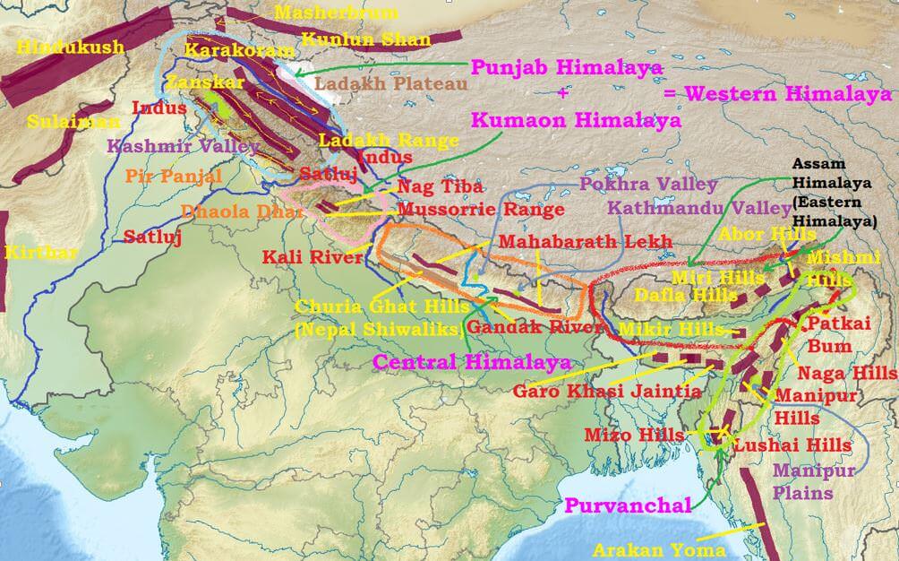
- Sir Sidney Burrard divided the whole length into four parts by river valleys, and this remains the common scheme.
| Section | Between | Length | Peaks | Marks |
|---|---|---|---|---|
| Kashmir, Punjab or Himachal Himalaya | Indus and Satluj | 560 km | K2 in the wider scheme, Nanga Parbat | Karewas, marg, duns; general height falls westward |
| Kumaun Himalaya | Satluj and Kali | 320 km | Nanda Devi, Kamet | Sources of Ganga and Yamuna; lakes, doons |
| Central or Nepal Himalaya | Kali and Tista | 800 km | Everest, Kanchenjunga, Makalu | Highest section; Kathmandu, Pokhara |
| Assam or Eastern Himalaya | Tista and Brahmaputra | 750 km (720 km in other counts) | Namcha Barwa, Kula Kangri | Lowest, steep south, heavy rain |
- Other schemes:
- Shiba Prasad Chatterjee (1964) used three meso-regions: Western (Kashmir, Punjab, Kumaun), Central (Nepal) and Eastern, with the north-eastern ranges added as Purvanchal.
- Ram Lochan Singh (1971) also used three, split differently: Western (Kashmir, Himachal), Central (Uttarakhand, Nepal) and Eastern (Darjeeling–Bhutan–Assam, Purvanchal).
- A threefold grouping is the tidiest for study:
| Division | Limits | Length | Provinces |
|---|---|---|---|
| Western Himalaya | Indus to Kali | 880 km | Kashmir, Himachal, Kumaon |
| Central Himalaya | Kali to Tista | About 800 km | Nepal, with Sikkim at its eastern end |
| Eastern Himalaya | Tista to Brahmaputra | About 720 km | Arunachal Pradesh, Bhutan |
Kashmir, Punjab or Himachal Himalaya
- Location: between the Indus gorge and the Satluj gorge, across Jammu and Kashmir, Ladakh and Himachal Pradesh.
- Size: 560 km long, about 320 km wide by the older figure. The whole region is also described as up to 500 km wide.
- Limits: the Zaskar range in the north and the Shiwaliks in the south. The section’s chief ranges are the Karakoram, Ladakh, Pir Panjal, Zaskar and Dhaola Dhar.
- Relief: ridge and valley. The Kashmir valley is a synclinal basin, filled with lake deposits of the Jhelum.
- General height falls westward. The Kashmir part averages nearly 3,000 m, with glaciated troughs.
- The Indus crosses it diagonally for about 650 km.
- Lakes: Wular and Dal are often listed as ox-bow lakes. Wular is more often read as a tectonic depression on the Jhelum, which shows that the valley floor has more than one lake type.
- Vale of Kashmir, also called “Heaven on Earth”.
- Its lake deposits are the Karewas, whose soils suit saffron from Pulwama to Pampore.
- Rain and snow: about 100 cm of precipitation, with winter snow.
- The sloping Zaskar and Pir Panjal enclose it. Their alpine grasslands are margs in Kashmir, such as Sonmarg and Gulmarg, and bugyals in Uttarakhand.
- Other ranges: Ratan Pir, which joins the Pir Panjal.
- Gateways: Banihal Pass was long the only all-weather route, by the Jawahar Tunnel, once called the second longest in India. It has been overtaken, for example by the 9.02 km Atal Tunnel, and the valley now also has a railway.
- Himachal part: all three ranges appear, with the Zaskar as the Greater, Pir Panjal and Dhauladhar as the Lesser, and the Shiwaliks as the Outer Himalaya.
- Southern slopes are rugged and forested; northern slopes are bare, with lakes on their flats.
- Valleys: Kullu, Kangra, Lahaul and Spiti.
- Passes: several passes on the Greater Himalaya connect Kashmir to Ladakh and beyond, such as Burzil and Zoji La. Himachal has Rohtang, Bara Lacha La and Shipki La.
Kumaun Himalaya
- Location: between the Satluj and Kali gorges, for 320 km. The western part is Garhwal and the eastern part Kumaon proper. It stands higher than the Punjab section.
- Ranges: Nag Tibba, Dhaola Dhar, Mussoorie and parts of the Greater Himalaya.
- Peaks: Nanda Devi (7,816 m), Kamet (7,756 m), Trisul (7,120 m), Badrinath (7,138 m), Kedarnath (6,968 m). Also Gangotri (6,510 m), Mana (7,273 m), Jaonli or Shivling (6,638 m) and Gayatri (6,515 m).
- Glaciers and rivers: Uttarakhand has many glaciers feeding the rivers, including Gangotri, Yamunotri and Pindari. Gangotri is the source of the sacred Ganga and the headwaters of the Yamuna also lie here.
- Climate and forest: winter snowfall; conifers above 3,200 m and deodar between 1,600 and 3,200 m.
- Rainfall is about 200 cm, more than in Kashmir, and the section is more vegetated.
- Hazard: prone to earthquakes and landslides, because rock is fractured and fragile. The Lesser Himalaya here includes weak shale, limestone and conglomerates.
- Basins: the Bhagirathi valley and the Doons.
- The Mussoorie and Nag Tiba ranges stand for the Lesser Himalaya, and the flat valleys to their south are Doons, with Dehra Dun the best known.
- Kullu, Manali and Kangra are tectonic valleys. By the river limits above, they lie in the Himachal part, west of the Satluj.
- Shiwaliks here run about 75 km between the Ganga and Yamuna, at 900–1,000 m.
- Lakes: about 36, including Nainital and Bhimtal.
- Hill stations are famous for their climate and colonial heritage.
- Passes to Tibet: Thaga La, Muling La, Mana, Niti, Marhi La, Kungri Bingri, Darma and Lipu Lekh.
Central or Nepal Himalaya
- Location: between the Kali in the west and the Tista in the east.
- Size: 800 km, the tallest section of the arc.
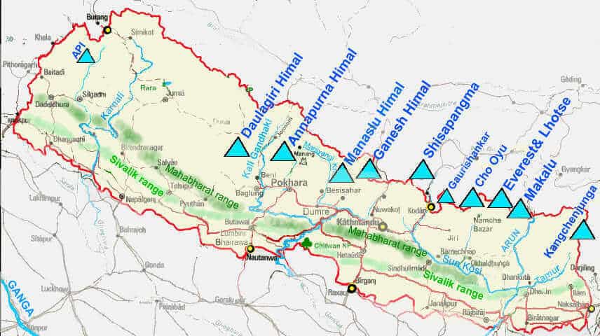
- World-famous peaks: Everest (Sagarmatha), Kanchenjunga, Makalu, Annapurna, Gosainthan and Dhaulagiri, with Lhotse and Cho Oyu.
- Plan: these ranges have an orthoclinal plan, with the Kathmandu valley in them.
- The Lesser Himalaya here is the Mahabharat Lekh.
- Rivers crossing the range: Ghaghara, Gandak, Kosi and others.
- Lake valleys: between the Great and Lesser Himalaya, Kathmandu and Pokhara are lacustrine valleys, former lakes.
- Going east, the Shiwaliks crowd up against the Lesser Himalaya, and past the Narayani (Gandak) little of them remains.
Assam or Eastern Himalaya
- Location: 750 km between the Tista in the west and the Brahmaputra (Dihang gorges) in the east, chiefly across Arunachal Pradesh and Bhutan, with Sikkim and Assam in older accounts.
- Height is much less than in Nepal. Southern slopes are very steep, northern slopes gentle.
- The Greater Himalaya is identifiable, but the Lesser and Shiwalik ranges are inseparable in many parts, and the Lesser range sits very close to the Greater.
- Peaks: Namcha Barwa (7,782 m), Kula Kangri (7,554 m), Chomo Lhari (7,327 m), Nozin Kang Sa (7,252 m), Gyala Peri (7,151 m), Kangto (7,090 m).
- Valleys are narrow, and rainfall is above 200 cm.
- Fluvial erosion dominates because of heavy rain. The section is highly dissected by ferocious rivers.
- Ice: the old claim of no ice caps or glaciers goes too far. Glaciers are fewer and smaller, as the section is closer to the tropics, but Sikkim has large ones such as Zemu.
- It is densely forested but landslide-prone, and earthquakes are very common, as rocks are fractured.
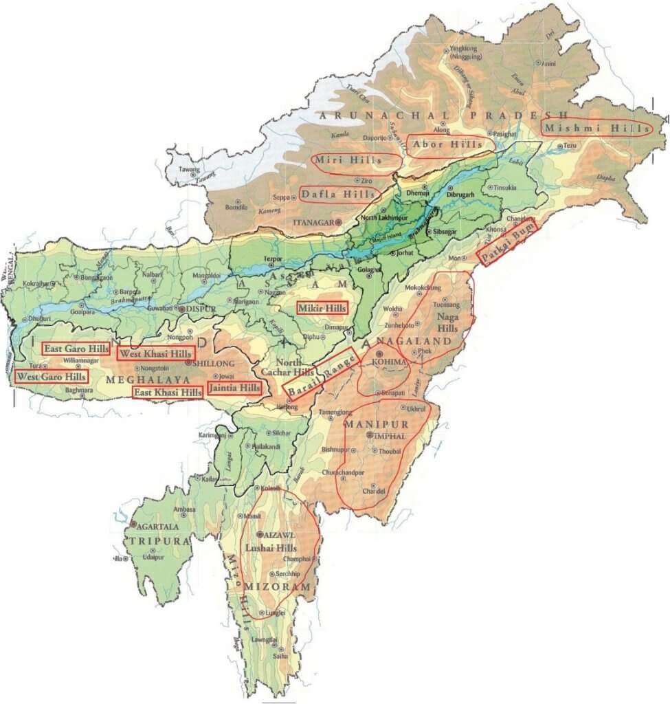
- People: inhabited by tribes, and the ranges are named after them: Dafla, Miri, Abor, Mishmi.
- Passes: Jelep La, Bum La, Tse La, Tunga, Yonggyap and Kangri Karpo La. Jelep La in the Chumbi valley and Bum La in Arunachal Pradesh lead towards Lhasa.
Purvanchal
- Geologically part of the Himalaya, but with structural differences that separate it from the main ranges.
- Position: south of the Brahmaputra valley.
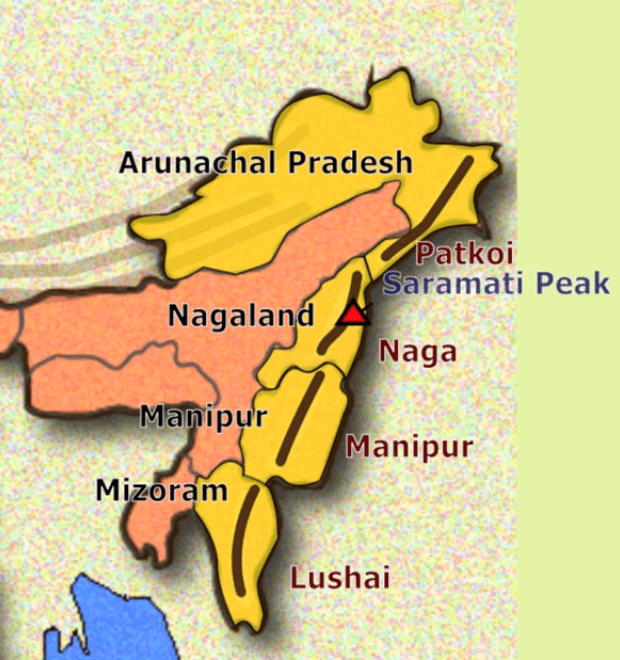
- Local names: Patkai Bum, Naga, Kohima, Manipur, Mizo, Tripura hills and the Barail range. The trend runs on through the Myanmar ranges towards the Andaman and Nicobar Islands and Indonesia.
- Naga hills: the highest peak is Saramati.
- Manipur hills: Loktak Lake, with Keibul Lamjao, the world’s only floating national park.
- Mizo hills: earlier Lushai hills; highest at the Blue Mountain.
- These hills belong to the Arakan Yoma orogenesis.
- Rocks: loose, fragmented sedimentary rocks such as shale, mudstone, sandstone and quartzite.
- It is the most fractured part of the Himalaya, with the Naga fault line, and so is prone to earthquakes and landslides.
- Rainfall: 150–200 cm. It is densely forested, but shifting cultivation puts its ecology at risk.
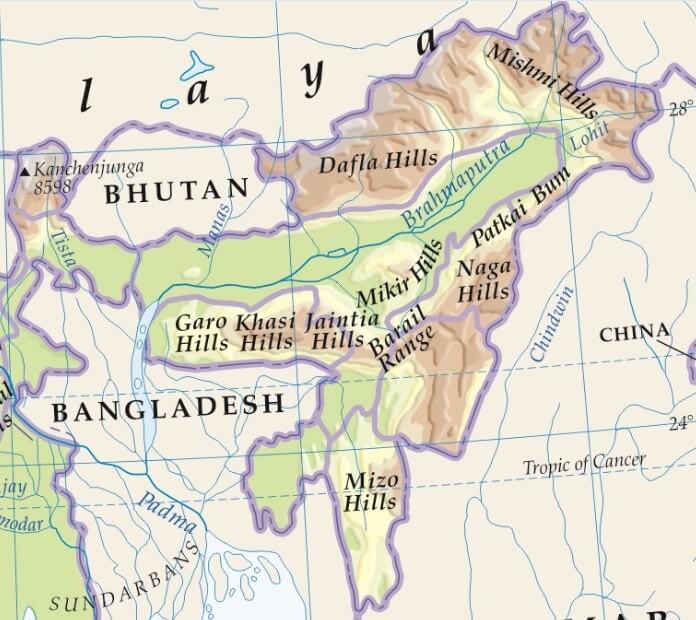
- This map gives Kanchenjunga’s older height. The current figure is 8,586 m.
Syntaxial Bends
- The east–west run of the Himalaya stops at each end, where the ranges take sharp southward turns. These are the syntaxial bends.
- Western bend: near Nanga Parbat, where the Indus cuts a deep gorge.
- The knee-shaped bend runs about 500 km deep, influencing the trend of the ranges perhaps as far as the foot of the Pamirs.
- Rock formations bend sharply, like a hairpin round a pivot.
- Eastern bend: at Namcha Barwa, conspicuous in Arunachal Pradesh, where the ranges swing south after crossing the Brahmaputra. Here the strike again forms a deep knee towards the south.
- Current view: both bends are sites of extreme rock uplift. Rocks at both massifs have been exhumed at about 9 km per million years, and the great rivers cutting through them are thought to strengthen this.
- The “tectonic aneurysm” idea of Peter Zeitler and others (2001) ties rapid river erosion to weak hot crust. Others hold that tectonics alone does it, and the question is open.
Trans-Himalayan Ranges
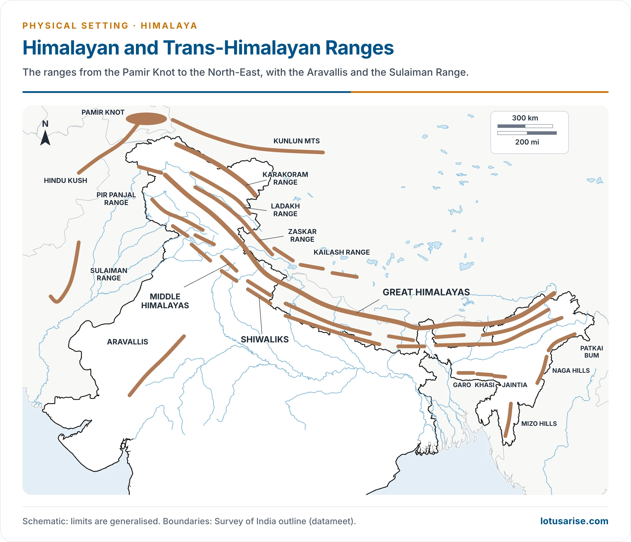
- The Trans-Himalaya or Tibet Himalayan region lies north of the Great Himalaya and consists of the Karakoram, Ladakh, Zaskar and Kailash ranges.
- Age: older accounts say these rose between the Jurassic and the Cretaceous, before the Himalaya, and so are not geologically part of it.
- That holds for the Ladakh and Kailas arc rocks in part, which belong to Asia’s old margin and stayed active until about 41 million years ago. The Zaskar belt is Indian-margin rock raised with the Himalaya.
- They emerge from the Pamir Knot.
- Karakoram: has the largest and highest peak, K2 or Godwin-Austen, India’s highest.
- Siachen is the highest battlefield and among the longest mountain glaciers. Baltoro is another of the largest, though the top rank is usually given to Siachen or Fedchenko.
- The Karakoram Pass leads towards Aksai Chin, an erosional plateau of about 4,000 m on average. Aksai Chin is Indian territory under Chinese occupation.
- Ladakh range: Rakaposhi was named as its highest point, though it stands beyond the Indus in the range’s north-west extension.
- Its extension in Tibet is the Kailash Range, where the Indus originates.
- The Brahmaputra rises near a great glacier, and Marium La divides the Indus and Tsangpo headwaters.
- The Indus flows between the Ladakh and Zaskar ranges.
- Zaskar Range: closely clubbed with the Great Himalaya. Its highest point is Nanga Parbat, cut off from the Ladakh by the Zaskar basin.
- Ladakh Plateau: a cold desert. In the north-west the Deosai mountains close the Trans-Himalayan region.
- Climate: the region gets its scant precipitation mainly in winter and is mostly barren.
- Highest peaks: K2 is the highest peak in India; Kangchenjunga is the highest in the Himalaya within India.
| Mountain peak | Height (m) |
|---|---|
| K2 (Godwin-Austen) | 8,611 |
| Kangchenjunga | 8,586 |
| Nanda Devi | 7,816 |
| Kamet | 7,756 |
| Saltoro Kangri | 7,742 |
| Saser Kangri | 7,672 |
| Mamostong Kangri | 7,516 |
| Rimo | 7,385 |
| Hardeol | 7,151 |
| Chaukhamba | 7,138 |
| Trisul | 7,120 |
Previous Year Questions
- No direct PYQ has been asked on this sub-topic yet.


 History Optional PYQ Master Pack: Topic-wise Model Answers (1985–2025) by LotusArise IAS
 History Optional Mains Master Kit 2027 Complete Self-Study System — Notes, Mapping & Premium Articles by LotusArise IAS
best material. Really happy that you are providing such good material for free
best notes ever. thanks alot
Thanks
Oh my God!!! We can’t thankyou enough for this…..This is beyond amazing…We will crack this exam and give you the credits for enriching us with such wisdom that too for free. Notes are covering everything and they are well updated.
your notes help me a lot thankyou
it covers all the points that important for the exam thankyou
good info
AWESOME
thank you