

- A climatic region has homogeneous climatic conditions, the result of a combination of factors.
- Temperature and rainfall are the two elements treated as decisive in all schemes of climatic classification. In India, rainfall varies far more than temperature, so most schemes give it greater weight.
- The whole of India has a monsoon type of climate, but the mix of weather elements reveals many regional variations. Location, altitude, distance from the sea and relief all add to them.
- In June, Barmer can touch 48°–50°C while Gulmarg stays near 22°C.
- Mawsynram receives over 1,100 cm a year, Jaisalmer about 12 cm in older figures.
- Henry Francis Blanford (1889) was so struck by this range that he preferred to speak of India’s climates, in the plural.
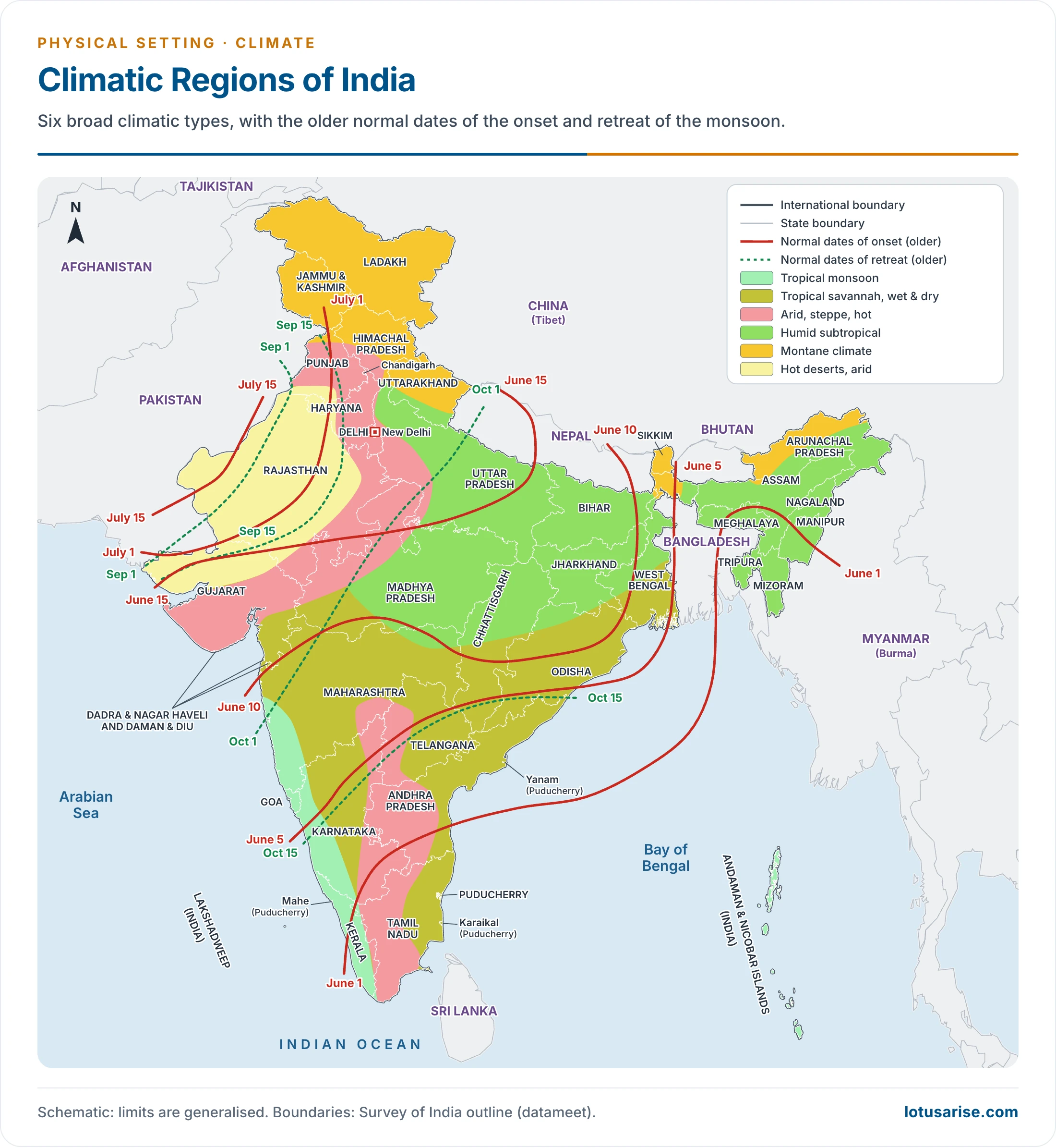
- On this map the monsoon onset and retreat lines are the older normal dates, such as 15 July for full cover and 1 September for first withdrawal. IMD revised these dates of the monsoon in 2020.
Schemes of Climatic Regionalisation
- On the basis of variations in climate, India can be divided into a number of climatic regions. The attempts fall into two groups:
| Group | Scholars | Basis |
|---|---|---|
| World schemes applied to India | Wladimir Köppen, Charles Warren Thornthwaite, Glenn Thomas Trewartha | Vegetation, temperature, effective rain |
| Schemes for India | Henry Francis Blanford (1889, the first attempt), Wilfrid George Kendrew, Laurence Dudley Stamp, Ram Lochan Singh (1971) | Temperature and rainfall by region |
| Other attempts | Basil Leonard Clyde Johnson, V. P. Subrahmanyam (1955), Bharucha and Shanbhag (1957) | Regional schemes for India |
- Each scheme is judged by how closely its boundaries match soils, vegetation and farming. On this test, the scheme of Trewartha suits India well: its regions correspond very closely with the soil, vegetative and agricultural regions.
Stamp’s Climatic Regions
- Stamp built on Kendrew. The scheme is empirical, and partly arbitrary and subjective, but its limits use simple units of temperature and rainfall.
- The master line: the 18°C January isotherm divides the country in two. It runs across the root of the Peninsula, roughly along the Tropic of Cancer.
- North of it lies temperate or continental India, with five regions.
- South of it lies tropical India, with six.
- The role of rainfall and temperature: temperature draws the first divide. Rainfall then separates the regions within each half, while coastal and cold-mountain regions add temperature range and altitude.
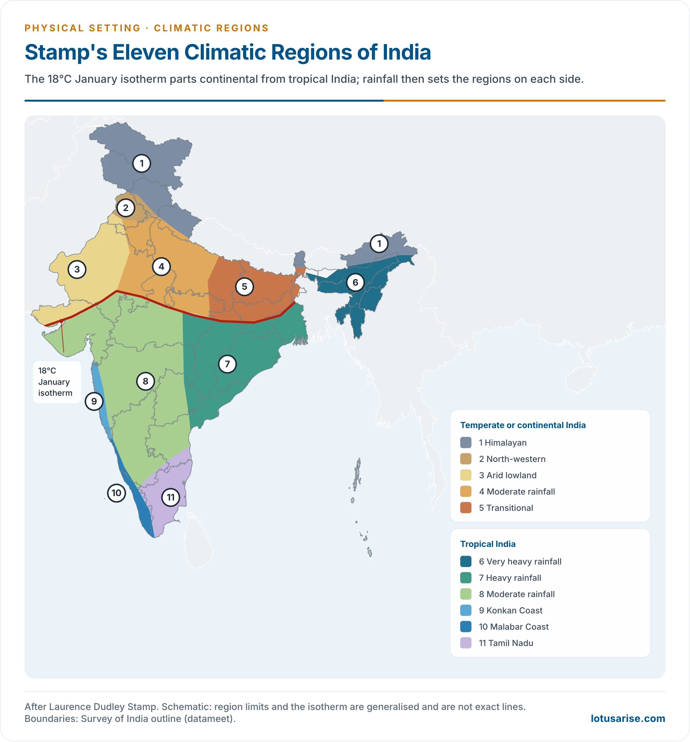
Temperate or Continental India
| Region | Areas | Annual rain (cm) | Temperature (°C) | City |
|---|---|---|---|---|
| 1. Himalayan | Jammu and Kashmir, Ladakh, Himachal Pradesh, most of Uttarakhand, Darjeeling hills, Sikkim, Arunachal Pradesh | Over 200 in the east, far less in the west | Winter 4–7; summer 13–18 | Shimla, Darjeeling |
| 2. North-western | Northern Punjab, southern Jammu and Kashmir | Moderate | Winter 16; summer 24 | Amritsar |
| 3. Arid lowland | Thar, south-west Haryana, Kachchh | Under 40 | Winter 16–24; summer up to 48 | Jaipur |
| 4. Moderate rainfall | Parts of Punjab and Haryana, west Uttar Pradesh, Delhi, north-west Madhya Pradesh, east Rajasthan | 40–80 | January 15–18; July 33–35 | Delhi |
| 5. Transitional | East Uttar Pradesh, Bihar | 100–150 | January 15–19; July 30–35 | Patna |
Tropical India
| Region | Areas | Annual rain (cm) | Temperature (°C) | City |
|---|---|---|---|---|
| 6. Very heavy rainfall | Meghalaya, Assam, Tripura, Mizoram, Nagaland | Over 200 | January about 18; July 32–35 | Cherrapunji, Mawsynram |
| 7. Heavy rainfall | Chhattisgarh, Jharkhand, Gangetic West Bengal, Odisha, coastal Andhra Pradesh | 100–200 | January 18–24; July 29–35 | Kolkata |
| 8. Moderate rainfall | Interior between the Western and Eastern Ghats | 50–100 | Winter 18–24; summer 32 | Hyderabad |
| 9. Konkan Coast | Mumbai to Goa | Over 200 | 24–27; range about 3 | Mumbai |
| 10. Malabar Coast | Goa to Kanniyakumari | Over 250 | Near 27; range about 3 | Thiruvananthapuram |
| 11. Tamil Nadu | Tamil Nadu and adjoining Andhra Pradesh | 100–150 | Near 24; range about 3 | Chennai |
- Why the rain differs:
- Region 6: the Bay branch meets the Meghalaya hills, where older figures give Cherrapunji 1,102 cm and Mawsynram 1,221 cm.
- Region 7: the Bay branch and Bay cyclones. Totals thin out westward and southward.
- Region 8: it lies behind the Western Ghats, in their rain shadow.
- Regions 9 and 10: the Arabian Sea branch. On the Malabar Coast the wet months run to about nine.
- Region 11: the retreating monsoon from the north-east, mostly in November and December.
- Evaluation:
- Strength: easily understood limits, and a clear link with the real pattern of rain.
- Weakness: the boundaries are lines drawn on judgement, with no test for how effective the rain is.
- The transition from Region 4 to Region 5 shows that the climate changes gradually, while a map gives a line.
Trewartha’s Classification of Climate
- Glenn Thomas Trewartha modified the classification of Köppen and presented it in 1954. His scheme is empirical, based on temperature and precipitation data, and he also used English letters as symbols.
- World types: A tropical humid, B dry, C humid mesothermal, D humid microthermal, E boreal, F polar, with H for undifferentiated highlands.
- Applied to India, the scheme gives four major climatic regions (A, B, C, H), further divided into seven meso-climatic divisions:
| Type | Name | Temperature | Rain (cm) | Areas |
|---|---|---|---|---|
| Am | Tropical rainforest or monsoon | Above 18.2°C; mean near 27°C | Over 200 (some maps 250) | Western coastal plain, Sahyadris, parts of Assam and Meghalaya, Tripura |
| Aw | Tropical savannah | Mean about 27°C | Under 100 | Most of the Peninsula, except coastal plains and western Ghats; Mizoram |
| BS | Tropical steppe | Mean about 27°C | Below 100 | Rain shadow east of the Western Ghats |
| BSh | Sub-tropical steppe | Mean over 27°C; January about 15°C | 60–75 | Parts of Gujarat, east Rajasthan, Maharashtra, Andhra Pradesh, south Haryana |
| BWh | Tropical arid | May–June maximum over 48°C | Under 25 | Thar Desert, west of the Aravallis; Kachchh |
| Caw | Humid subtropical | January under 18°C; summer maximum over 45°C | 250 in the east to about 65 in the west | Great Plains from Punjab to Assam |
| H | Mountain | Summer about 17°C; January about 8°C | Falls from east to west | Jammu and Kashmir, Himachal Pradesh, Uttarakhand, Arunachal Pradesh, north-east hills |
- Tropical Rainforest Climate (Am):
- High temperature and heavy precipitation.
- Dense forests, chiefly of evergreen trees, are the characteristic vegetation.
- The Tropical Savannah Climate (Aw):
- It has a marked dry season, and nearly all the rain falls in summer.
- The Tropical Steppe Climate (BS):
- It covers Peninsular India east of the Western Ghats, the rain-shadow area in parts of Maharashtra, Telangana, Andhra Pradesh, Karnataka and Tamil Nadu.
- Rayalaseema belongs here. Its low, unreliable rain and high temperatures follow from its place behind the Ghats, with too little of either monsoon to make up the gap.
- The Sub-tropical Steppe Climate (BSh):
- It is semi-arid, and its annual range of temperature is significantly high.
- The Tropical Arid Climate (BWh):
- Thorny bushes make up the natural vegetation.
- Older accounts record the country’s lowest rainfall in Ganganagar district. Jaisalmer and the cold desert of Ladakh are at least as dry.
- The Humid Subtropical Climate (Caw):
- Winters are dry, and western disturbances add light rain in the west.
- Mountain Climate (H):
- Mean temperatures for all months depend closely on topography and slope.
- The Western Himalayas get some rain from western disturbances in the winter season.
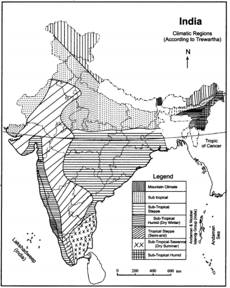
- Key to the letters: A Tropical climate, B Dry climate, C Humid subtropical climate, D Humid temperate climate, E Polar climates, H Highlands.
- The legend of this map needs care. Its “sub-tropical humid (dry winter)” belt over central India is the tropical savannah (Aw) of the text. Its “sub-tropical savanna (dry summer)” in Tamil Nadu is the tropical As type with its winter rain.
Other Schemes
Köppen’s Scheme in Brief
- Wladimir Köppen first published his world scheme around 1900 and revised it until 1936. Its classification system uses monthly and annual means of temperature and rain, and treats native vegetation as the truest sign of a climate.
- Five major types apply worldwide: A tropical rainy, B dry, C mild mid-latitude, D severe mid-latitude, E polar.
- Small letters add detail: a hot summer, c cool summer, f no dry season, w dry winter, s dry summer, g Ganges-type hot season before the solstice, h hot and dry (mean above 18°C), m monsoon with a short dry season.
- Nine regions are usually mapped in India:
| Type | Character | Areas |
|---|---|---|
| Amw | Monsoon, short dry winter | West coast south of Mumbai; over 300 cm |
| As | Monsoon, dry summer | Coromandel coast; 75–100 cm, mostly in winter |
| Aw | Tropical savannah | Most of the Peninsular plateau; about 75 cm |
| BShw | Semi-arid steppe | Rain shadow of the Ghats, Rajasthan, parts of Haryana and Gujarat; 12–25 cm |
| BWhw | Hot desert | Western Rajasthan; under 12 cm |
| Cwg | Monsoon, dry winter, Ganges type | Ganga Plain, east Rajasthan, Assam, Malwa |
| Dfc | Cold, humid winter, short summer | Sikkim, Arunachal Pradesh, parts of Assam |
| Et | Tundra | Mountains of Uttarakhand |
| E | Polar | High Jammu and Kashmir, Ladakh, Himachal Pradesh |
- Limit: it uses no direct measure of evaporation, and its fixed limits sit poorly on a monsoon country with sharp relief.
Thornthwaite’s Scheme
- Charles Warren Thornthwaite published his classification in 1931, and a markedly different one in 1948.
- 1931: the plant is a meteorological instrument. Precipitation effectiveness (12 monthly P/E ratios added together) and thermal efficiency (T/E) set the types. The Indian map below uses this version.
- 1948: vegetation becomes the means by which water passes from soil to air, and potential evapotranspiration replaces the old indices, the core of Thornthwaite’s classification.
| Humidity province | Vegetation | P/E index | Temperature province | T/E index |
|---|---|---|---|---|
| A, wet | Rainforest | 128 and above | A’, tropical | 128 and above |
| B, humid | Forest | 64–127 | B’, mesothermal | 64–127 |
| C, subhumid | Grassland | 32–63 | C’, microthermal | 32–63 |
| D, semi-arid | Steppe | 16–31 | D’, taiga | 16–31 |
| E, arid | Desert | Under 16 | E’, tundra; F’, frost | 1–15; 0 |
- Seasonal letters: r adequate rain in all seasons; s summer deficient; w winter deficient; d deficient in all seasons.
- Of 120 possible combinations he mapped 32 on the world map. Twelve occur in India:
| Type | Character | Areas |
|---|---|---|
| AA’r | Tropical wet | West coast, Tripura, Mizoram |
| BA’w | Tropical humid | Eastern slopes of the Western Ghats, West Bengal |
| BB’w | Temperate humid | Parts of Assam, Meghalaya, Mizoram, Nagaland |
| CA’w | Tropical subhumid | Much of the Peninsula |
| CA’w’ | The same, with winter rain | Tamil Nadu and neighbouring Andhra Pradesh |
| CB’w | Temperate subhumid | Most of the northern plain |
| DA’w | Tropical semi-arid | North Gujarat, south Rajasthan |
| DB’d | Temperate semi-arid, dry all year | Jammu and Kashmir |
| DB’w | Temperate semi-arid, dry winter | Parts of Punjab, Haryana, Rajasthan, the rain shadow |
| D’ | Taiga | Western Himalaya; Arunachal Pradesh, Sikkim, upper Assam |
| E’ | Tundra | Higher Himalaya |
| EA’d | Hot and dry all year | Western Rajasthan |
R. L. Singh’s Climatic Divisions
- Singh (1971), following Kendrew and Stamp, set ten divisions by the temperature of the hottest and coldest months and by annual rain. It keeps close to India’s relief and to the humid-to-arid gradient.
| Division | Areas | Rain (cm) | Temperature (°C) |
|---|---|---|---|
| 1. Per-humid North-East | Sikkim, Assam, Arunachal Pradesh, Nagaland, Tripura, Mizoram, Meghalaya | About 200, locally over 1,000 | January 11–24; July 25–33 |
| 2. Humid Sahyadri and West Coast | Western Ghats and coast, Narmada to Kanniyakumari | About 200 | January 19–28; July 26–32 |
| 3. Humid South-East | Odisha, West Bengal, Chhattisgarh, Jharkhand | 100–200 | January 12–27; July 26–34 |
| 4. Sub-humid Transition | East Uttar Pradesh, Bihar, north Jharkhand | 100–200 | January 9–24; July 24–41 |
| 5. Sub-humid Littorals | East Tamil Nadu, coastal Andhra Pradesh | 75–150 | January 20–29; May 28–38 |
| 6. Sub-humid Continental | Ganga plain | 75–150 | January 7–23; July 26–41 |
| 7. Semi-arid Subtropical | Punjab, Haryana, east Rajasthan, Delhi, Chandigarh | 25–100 | January 6–23; May 26–41 |
| 8. Semi-arid Tropical | Gujarat, Maharashtra, Madhya Pradesh, Chhattisgarh, Karnataka, Telangana | 50–100 | January 13–29; July 26–42 |
| 9. Arid | Western Rajasthan, south-west Haryana, Kachchh | About 25, at places 10 | January 5–22; June 20–40 |
| 10. West Himalayan | Jammu and Kashmir, Ladakh, Himachal Pradesh, Uttarakhand | About 150 | January 0–4; July 5–30 |
Comparing the Schemes
| Scheme | Basis | Regions in India | Strength | Weakness |
|---|---|---|---|---|
| Köppen | Temperature, rain, vegetation | 9 | Worldwide comparison | No direct evaporation measure |
| Thornthwaite | Effective rain, heat | 12 | Treats rain by its usefulness | Data-heavy; many letters |
| Trewartha | Temperature, rain | 7 | Simple; fits soils and farming | Coarse within the plains |
| Stamp | 18°C line, rain | 11 | Clear, direct and regional | Judgement-based limits |
| R. L. Singh | Extreme months, rain | 10 | Close to India’s regions | Overlapping ranges |
- The same logic applied at a finer scale for farming gives the agro-climatic zones. The wider picture appears under the world’s climatic regions.
Previous Year Questions
2018Critically examine the basis and scheme of climatic classification proposed by G. T. Trewartha.2016Discuss the role of spatial pattern of rainfall and temperature in the delimitation of climatic regions of India, especially with reference to Stamp’s climatic regionalisation.2014Describe the salient climatological characteristics of the Rayalaseema region.2012Discuss the role of spatial pattern of rainfall and temperature in the delimitation of climatic regions of India, especially with reference to stamp’s climatic regionalization.2004Discuss the role of spatial pattern of rainfall and temperature in the delimitation of climatic regions of India, especially with reference to Stamp’s climatic regionalization.1996Draw a sketch-map in your answer book to delineate the main climatic regions of India and discuss the important climatic characteristics of each region.1988Evaluate the Koppen’s scheme of climatic regionalisation of India.





Thanks sir..
Thanx really helpful
Can you tell what type of climate is found in Meghalaya, Tripura and Mizoram because there is no climate mentioned here in the map shown by you.
it is tropical rain forest only. as mentioned in the text
Also tell that what is the source of this map that you have mentioned showing the climatic regions of the India according to Trewartha.