

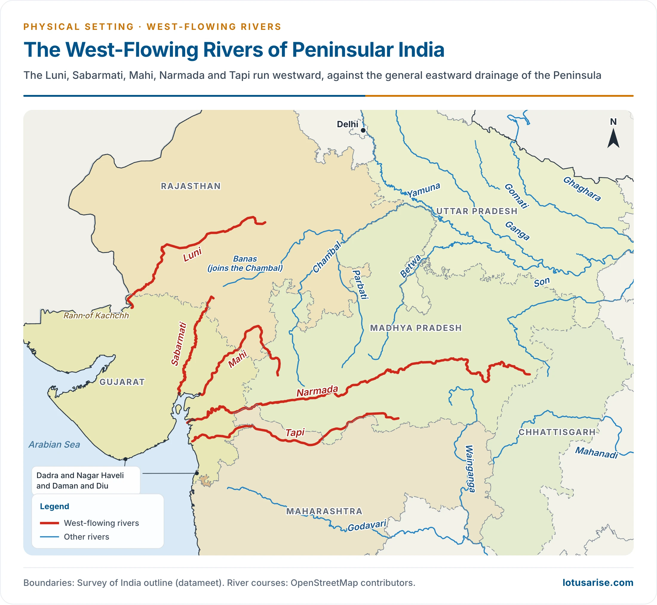
- India is a geographical paradise with a multitude of rivers. Most join the Bay of Bengal, but a few defy the general slope and flow west, ending in the Arabian Sea.
- The Arabian Sea drainage takes in about 23% of the country’s drainage area, including the Indus system.
West Flowing Rivers of Peninsular India
General Features
- These rivers are fewer and shorter than those draining to the Bay.
- The Narmada and the Tapi lead them.
- Other rivers: Shetrunji, Bhadra (Bhadar), Dhandhar, Sabarmati, Mahi, Vaitarana, Kalinadi, Bedti, Sharavati (Sharvati), Mandovi, Zuari (Juari), Bharathapuzha (Bharatpuzha), Periyar and Pamba.
- The Sabarmati, Mahi and Luni also flow west across the northern part of the Peninsula.
- Hundreds of short streams from the Western Ghats run swiftly to the Arabian Sea.
- Why the Narmada and Tapi run west: this behaviour is exceptional. They did not cut their own valleys, but occupy faults (linear rifts, rift valleys, troughs).
- The faults are linked to the bending or sagging of the northern Peninsula while the Himalaya rose.
- They run parallel to the Vindhyas and the Satpuras.
- Evolution: one long-held view holds that the Sahyadri–Aravalli axis was once the main divide, and that the land to its west foundered beneath the Arabian Sea in the early Tertiary.
- The straight west coast, the steep western face of the Ghats and the lack of deltas are read as evidence. The wider story belongs with India’s drainage evolution.
No Deltas, Only Estuaries
- A striking trait: Peninsular rivers falling into the Arabian Sea form estuaries, not deltas.
- The older explanation: the Narmada and Tapi flow through hard rocks and carry little silt. Their tributaries are very small and add little more, so they cannot form distributaries or a delta.
- The current correction: the silt argument does not hold. Before its large dams the Narmada carried about 34 million tonnes a year at Garudeshwar, and Sardar Sarovar now traps 60–80% of it.
- A 2026 study of the Narmada and Tapi finds sediment fluxes comparable with delta-forming rivers. The problem is low retention, not low supply:
- Steep, rift-confined channels leave little floodplain.
- Monsoon stream power keeps sediment in suspension.
- Strong tides in the Gulf of Khambhat carry it offshore.
- A 2026 study of the Narmada and Tapi finds sediment fluxes comparable with delta-forming rivers. The problem is low retention, not low supply:
Rivers That Never Reach the Sea
- A few rivers in Rajasthan do not reach the sea. They drain into salt lakes or vanish in sand.
- Desert rivers flow for some distance before being lost: the Luni, Machhu, Rupen, Saraswati, Banas and Ghaggar.
- The Machhu, Rupen, Saraswati and Banas end in the Little Rann of Kachchh.
Estuary
- An estuary is a partly enclosed coastal water body where fresh river water mixes with salt sea water.
- Primary productivity is very high, fishing is a main occupation around estuaries, and most of them are good bird sanctuaries.
- Transition zone: estuaries and their surrounding lands mark the change from land to sea and from fresh water to salt water.
- Shelter: they feel the tides, yet barrier islands or peninsulas protect them from the full force of waves, winds and storms.
- Productivity: they create more organic matter each year than comparably sized forest, grassland or farmland.
- Life: their tidal, sheltered waters hold distinct plant and animal communities adapted to the margin of the sea.
- Economy: they support tourism, fisheries and recreation.
- Infrastructure: their protected waters house harbours and ports vital for shipping and transport.
- Filtering: upland water brings sediments, nutrients and pollutants. As it passes through swamps and salt marshes, much of this is filtered out.
- Shoreline: salt-marsh grasses and other estuarine plants, including mangroves, prevent erosion and stabilise shorelines.
The Major West-Flowing Rivers
| River | Source | Length (km) | Basin (sq km) | Mouth |
|---|---|---|---|---|
| Narmada | Amarkantak, 1,057 m | 1,312 | 98,796 | Gulf of Khambhat |
| Tapi | Near Multai, 752 m | 724 | 65,145 | Gulf of Khambhat |
| Mahi | Dhar district, 500 m | 583 | 34,842 | Gulf of Khambhat |
| Sabarmati | Near Tepur, 762 m | 371 | 21,674 | Gulf of Khambhat |
| Luni | Ajmer district, 772 m | 511 | 32,879 | Lost in the Rann of Kachchh |
Narmada River
- Rank: the largest west-flowing river of Peninsular India.
- Setting: it flows west along a rift valley, with the Vindhyas to its north and the Satpuras to its south.
- Source: the Maikala range near Amarkantak in Madhya Pradesh, now Anuppur district, at about 1,057 m.
- Length: 1,310 km in many older accounts. The Central Water Commission (CWC) now gives 1,312 km: 1,079 km in Madhya Pradesh, 35 km along Madhya Pradesh–Maharashtra, 39 km along Maharashtra–Gujarat and 159 km in Gujarat.
- Basin: about 1 lakh sq km, or exactly 98,796 sq km, in Madhya Pradesh, Gujarat, Maharashtra and Chhattisgarh. Madhya Pradesh holds 86.15%.
- Bounded by the Vindhyas on the north, the Maikala range on the east, the Satpuras on the south and the Arabian Sea on the west.
- The basin is long and narrow, at 923 km by 161 km at most.
- Land: hilly tracts lie in the upper basin, and the lower middle reaches are broad and fertile plains. Black soils are dominant.
- Urban centre: Jabalpur is the only important one in the basin.
- Mouth: its estuary opens into the Gulf of Khambhat, about 28 km wide.
- It has several islands, of which Aliabet is the largest.
- It is navigable up to 112 km from the mouth.
- Water: older mean flow is 40,700 million cubic metres, and the 2019 CWC figure is 58.21 billion cubic metres.
- It has a very low flow from January to June, and a sudden monsoon peak of about 5,000 cumecs on a monthly mean at Garudeshwar.
Falls on the Narmada:
- Dhuan Dhar (Cloud of Mist) Falls: near Jabalpur the river cascades 15 m into a gorge. A cascade is a small waterfall, especially one in a series.
- The gorge is of marble, hence the name Marble Rocks.
- Mandhar and Dardi: two falls of 12 m each.
- Sahasradhara Falls: near Maheshwar, a small drop of 8 m.
- Kapildhara: a 23 m fall on the upper river.
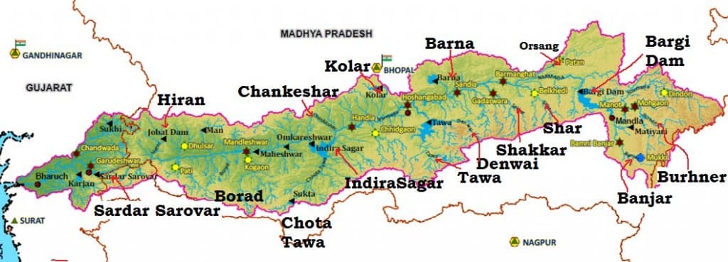
Tributaries of the Narmada River
- The confined valley leaves little room for long tributaries, especially on the right bank.
- Hydropower: the major projects are Indira Sagar, Sardar Sarovar, Omkareshwar, Bargi and Maheshwar.
| Bank | Tributary | Length (km) | Catchment (sq km) |
|---|---|---|---|
| Right | Hiran | 188 | 4,808 |
| Right | Tendoni | 117 | 1,637 |
| Right | Barna | 105 | 1,793 |
| Right | Kolar | 101 | 1,351 |
| Right | Man | 88 | 1,533 |
| Right | Uri | 74 | 1,819 |
| Right | Hatni | 80 | 1,949 |
| Right | Orsang | 101 | 4,093 |
| Left | Burhner | 177 | 4,132 |
| Left | Banjar | 183 | 3,639 |
| Left | Sher | 129 | 2,911 |
| Left | Shakkar | 161 | 2,300 |
| Left | Dudhi | 129 | 1,546 |
| Left | Tawa | 172 | 6,355 |
| Left | Ganjal | 88 | 1,936 |
| Left | Chhota Tawa | 169 | 5,068 |
| Left | Kundi | 121 | 3,834 |
| Left | Goi | 129 | 1,897 |
| Left | Karjan | 93 | 1,494 |
- The right-bank Choral River, listed in some sources, and a small left-bank Kaveri River, not the southern Cauvery, also join the Narmada.
Tawa River
- It rises in the Satpura Range of Betul in Madhya Pradesh.
- Older accounts call it the longest tributary of the Narmada. Narmada Control Authority figures make it the largest by catchment, at 6,355 sq km. The Hiran and Banjar are longer.
Sharing the Narmada
- Tribunal: the Narmada Water Disputes Tribunal gave its award on 7 December 1979, assessing 28 million acre feet as the utilisable flow.
- Shares: Madhya Pradesh 18.25, Gujarat 9, Rajasthan 0.5, Maharashtra 0.25.
- It may be reviewed after 45 years, a point now reached.
- Sardar Sarovar power is shared 57% to Madhya Pradesh, 27% to Maharashtra and 16% to Gujarat.
- Sardar Sarovar Dam: an older height of 121.92 m was followed by approval of gates in 2014.
- The dam was dedicated on 17 September 2017, and the reservoir first filled to its full level of 138.68 m in September 2019.
- It irrigates about 18 lakh hectares in Gujarat, plus an allocated area in Rajasthan.
- Controversy: large-scale submergence and displacement made it India’s most contested dam project. Bargi, Indira Sagar and Sardar Sarovar all displaced many people. The Narmada Bachao Andolan took the matter to the Supreme Court.
Tapti River
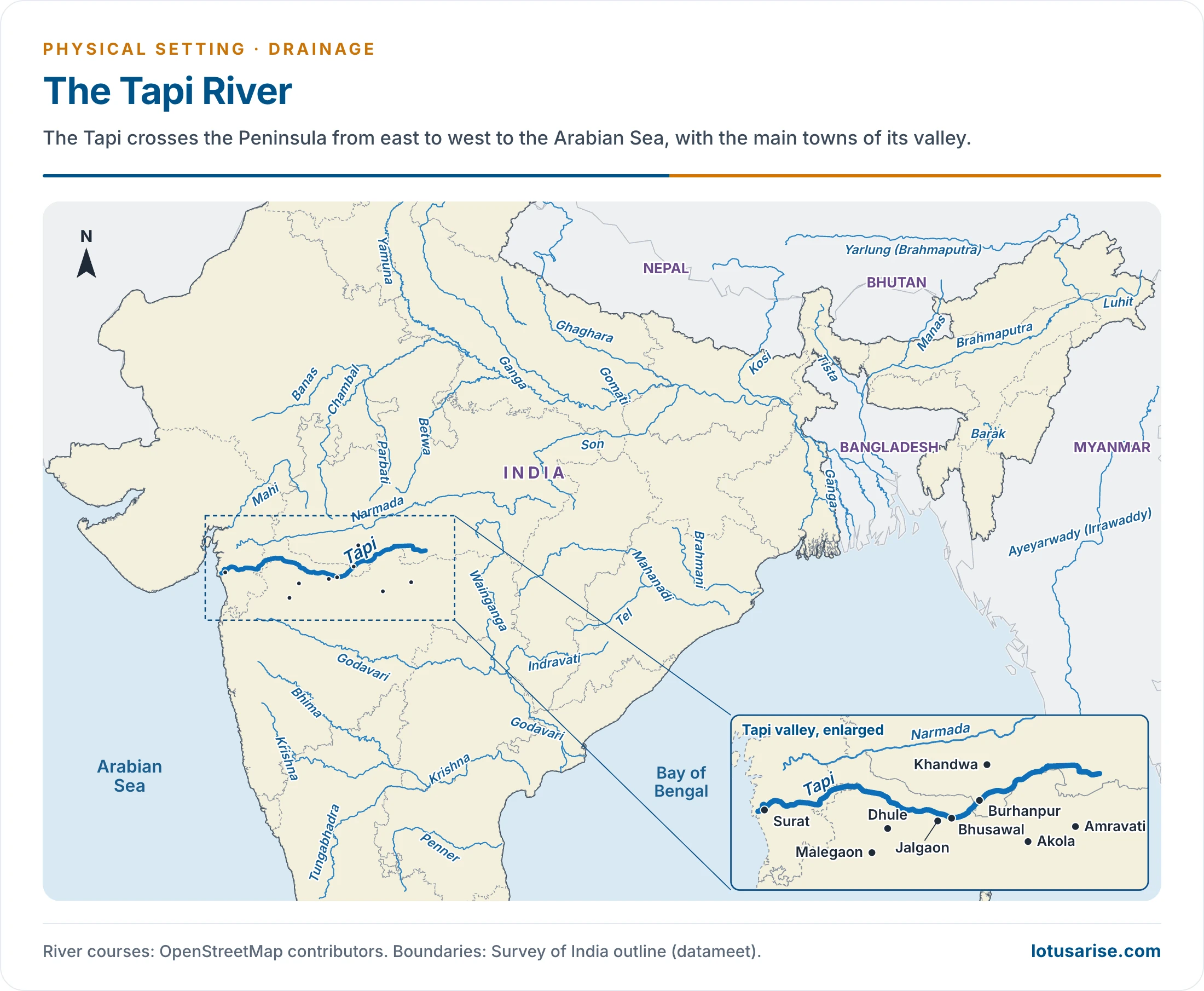
- The Tapti (also known as the Tapi) ranks next after the Narmada among west-flowing rivers, and is called its “twin” or “handmaid”.
- Source: near Multai reserve forest in Madhya Pradesh’s Betul district, at 752 m. Older figures give 730 m and link the source to the sacred tank of Multai.
- Length: about 724 km to the Arabian Sea, through the Gulf of Cambay (Gulf of Khambhat). The older figure is 730 km.
- It runs 282 km in Madhya Pradesh, 228 km in Maharashtra and 214 km in Gujarat.
- Course: across the plains of Vidarbha (Vidharbha), Khandesh and Gujarat, covering large areas of Maharashtra and small areas of Madhya Pradesh and Gujarat.
- It cuts a deep and narrow passage across the Western Ghats, then the alluvial plain of Surat, and ends in an estuary.
- The tidal reach is put at 48 km in older accounts and about 20 km by CWC. Boats can go only about 32 km up it.
- Basin: about 65,000 sq km, or exactly 65,145 sq km. Maharashtra holds about 79% (51,504 sq km), Madhya Pradesh 9,804 and Gujarat 3,837.
- Situated in the Deccan plateau, it is bounded by the Satpura range on the north, the Mahadev hills on the east, the Ajanta Range and Satmala hills on the south, and the Arabian Sea on the west.
- Two physical regions:
- Hills: the Satpura, Satmala, Mahadeo, Ajanta and Gawilgarh hills, well forested.
- Plains: the Khandesh areas, broad and fertile. Khandesh is a region forming the north-western part of Maharashtra.
- Water: older mean flow is 17,980 million cubic metres, and the 2019 CWC figure is 26.24 billion cubic metres.
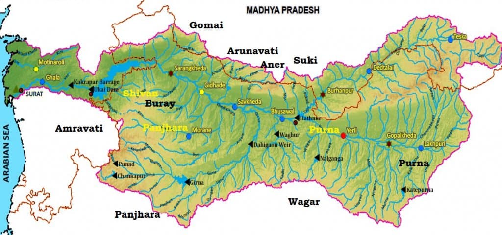
Tributaries of the Tapti River
- Right bank: the Suki, the Gomai, the Arunavati and the Aner.
- Left bank: the Vaghur, the Amravati, the Buray, the Panjhra, the Bori, the Girna, the Purna, the Mona and the Sipna.
- The Purna and the Girna together make up nearly 45% of the catchment. The Purna rises in the Gawilgarh hills and joins near Bhusawal, draining 18,929 sq km.
Projects on the Tapti River
- Hathnur Dam of the Upper Tapi Project (Maharashtra).
- Kakrapar weir and Ukai Dam of the Ukai Project (Gujarat).
- Girna Dam and Dahigam Weir of the Girna Project (Maharashtra).
Industry in the Tapti Basin
- Important industries: textile factories in Surat and a paper and newsprint factory at Nepanagar.
Sabarmati River
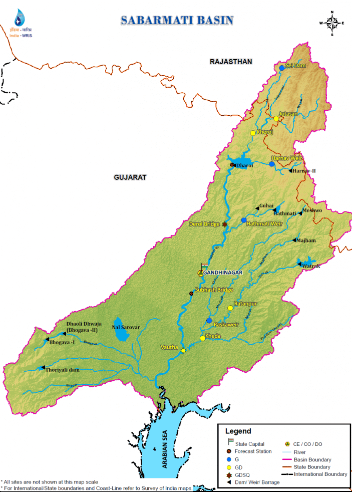
- Name: the Sabarmati is the combined stream of the Sabar and Hathmati.
- Basin: across Rajasthan and Gujarat, 21,674 sq km.
- Bounded by the Aravalli hills on the north and north-east, the Rann of Kutch on the west, and the Gulf of Khambhat on the south.
- Roughly triangular, with the river as the base and the source of the Vatrak River as the apex.
- Source: the Aravalli hills at 762 m, near Tepur village in Udaipur district of Rajasthan.
- Length: 371 km to the Arabian Sea. The older figure is 320 km. It passes through a gorge at Dharoi.
- Land use: agriculture covers 74.68% of the basin.
- Rainfall: from a meagre few millimetres in Saurashtra to over 1000 mm in the southern part.
- Tributaries:
- Left bank: the Wakal, the Hathmati and the Vatrak, with the Harnav and Meshwo.
- Right bank: the Sei.
- Projects: Sabarmati reservoir (Dharoi), Hathmati reservoir and Meshwo reservoir, major works of the Plan period.
Industry in the Sabarmati Basin
- Urban centres: Gandhinagar and Ahmedabad.
- Ahmedabad is an industrial city on the Sabarmati’s banks.
- Important industries: textiles, leather and leather goods, plastic, rubber goods, paper, newsprint, automobiles, machine tools, drugs and pharmaceuticals.
- Pollution: industrial Ahmedabad poses a danger of water pollution.
Mahi River
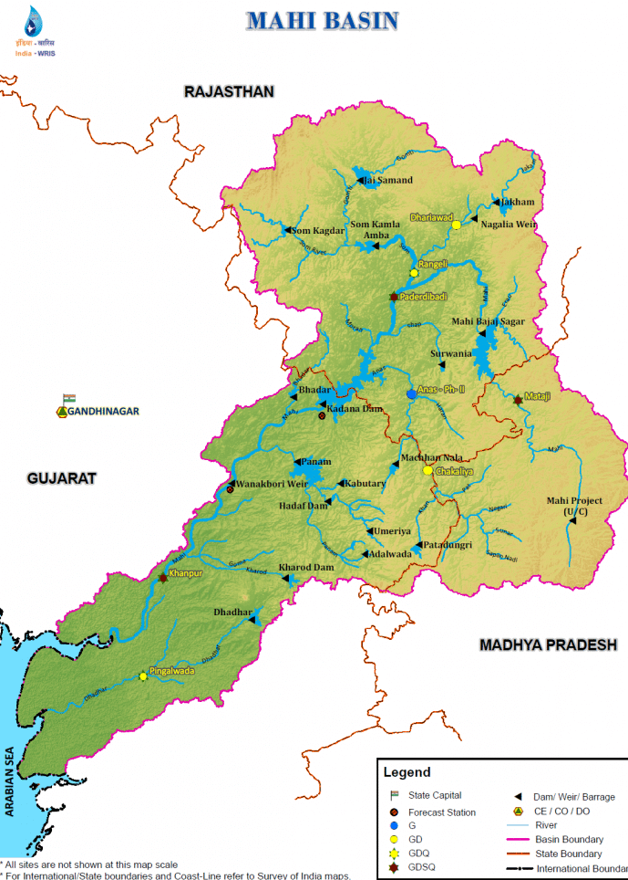
- Basin: across Madhya Pradesh, Rajasthan and Gujarat, 34,842 sq km. Madhya Pradesh holds 19%, Gujarat 34% and Rajasthan 47%.
- Bounded by the Aravalli hills on the north and north-west, the Malwa Plateau on the east, the Vindhyas on the south, and the Gulf of Khambhat on the west.
- Rank: one of the major inter-State west-flowing rivers of India.
- Source: the northern slopes of the Vindhyas at 500 m, in Dhar district of Madhya Pradesh.
- Length: 583 km. The older figure is 533 km.
- Course: a looping path, north through Madhya Pradesh, then through Banswara in Rajasthan, and south-west through Gujarat. It crosses the Tropic of Cancer twice.
- Mouth: an estuary on the Arabian Sea through the Gulf of Khambhat.
- Land use: agricultural land covers 63.63% of the basin.
- Hydropower and storage: Mahi Bajaj Sagar dam, Kadana Dam and Wanakbori dam (weir).
- Urban and industry: Vadodara is the only important urban centre, and there are few industries.
- Cotton textiles, paper, newsprint, drugs and pharmaceuticals exist, mostly at Ratlam.
Tributaries of the Mahi:
- Som (right bank):
- It rises near Som on the eastern slopes of the Aravalli hills in Udaipur district of Rajasthan, at 600 m above m.s.l., and flows east.
- It joins the Mahi 6.3 km upstream of the Paderdibadi site in Dungarpur district.
- It is about 155 km long and drains 8,707 sq km.
- Gomti and Jakham are its major right-bank sub-tributaries.
- Anas (left bank):
- It rises near Kalmora on the northern slopes of the Vindhyas in Jhabua district of Madhya Pradesh, at 450 m, and flows north-west.
- It joins the Mahi in Dungarpur district.
- It is about 156 km long and drains 5,604 sq km.
- Panam (left bank):
- It rises near Bhadra on the northern slopes of the Vindhyas, near Jhabua district, at about 300 m, and flows north-west.
- It joins the Mahi in the Panchmahal district of Gujarat.
- It is about 127 km long and drains about 2,470 sq km.
Luni River
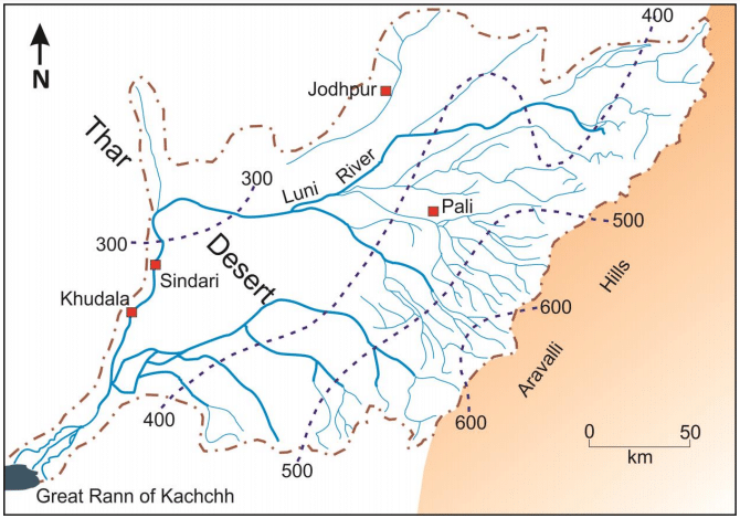
- Name: the Luni is also the Salt River (Sanskrit Lonari or Lavanavari), after water that turns brackish below Balotra.
- In its upper course it is known as the Sagarmati, taking the name Luni after the Sarsuti joins it near Govindgarh.
- Significance: the only river basin of any size in Western Rajasthan, which makes up most of the arid zone.
- Source: the western slopes of the Aravalli ranges at 772 m, near Ajmer. Older figures give 550 m.
- Course: south-west for 511 km (older figure 482 km). It ends in the Rann of Kachchh, where it spreads out and is lost in the marsh.
- Tributaries: most drain the steep north-west face of the Aravalli and join on the left: the Lilri, Guhiya, Bandi, Sukri, Jawai, Khari Bandi, Sukri Bandi and Sagi. The Jojri joins on the right.
- Catchment: 32,879 sq km. It lies almost wholly in Rajasthan, with the river’s last stretch reaching the Rann in Gujarat.
- A peculiarity: the river widens rather than deepens its bed.
- Its banks are of soil that erodes easily, while its bed is of sand.
- Floods rise and fall so rapidly that they have no time to scour the bed.
West Flowing Rivers of the Sahyadris (Western Ghats)
- About six hundred small streams rise in the Western Ghats and run west to the Arabian Sea.
- Supply: the western slopes get heavy south-west monsoon rain, which feeds so many streams.
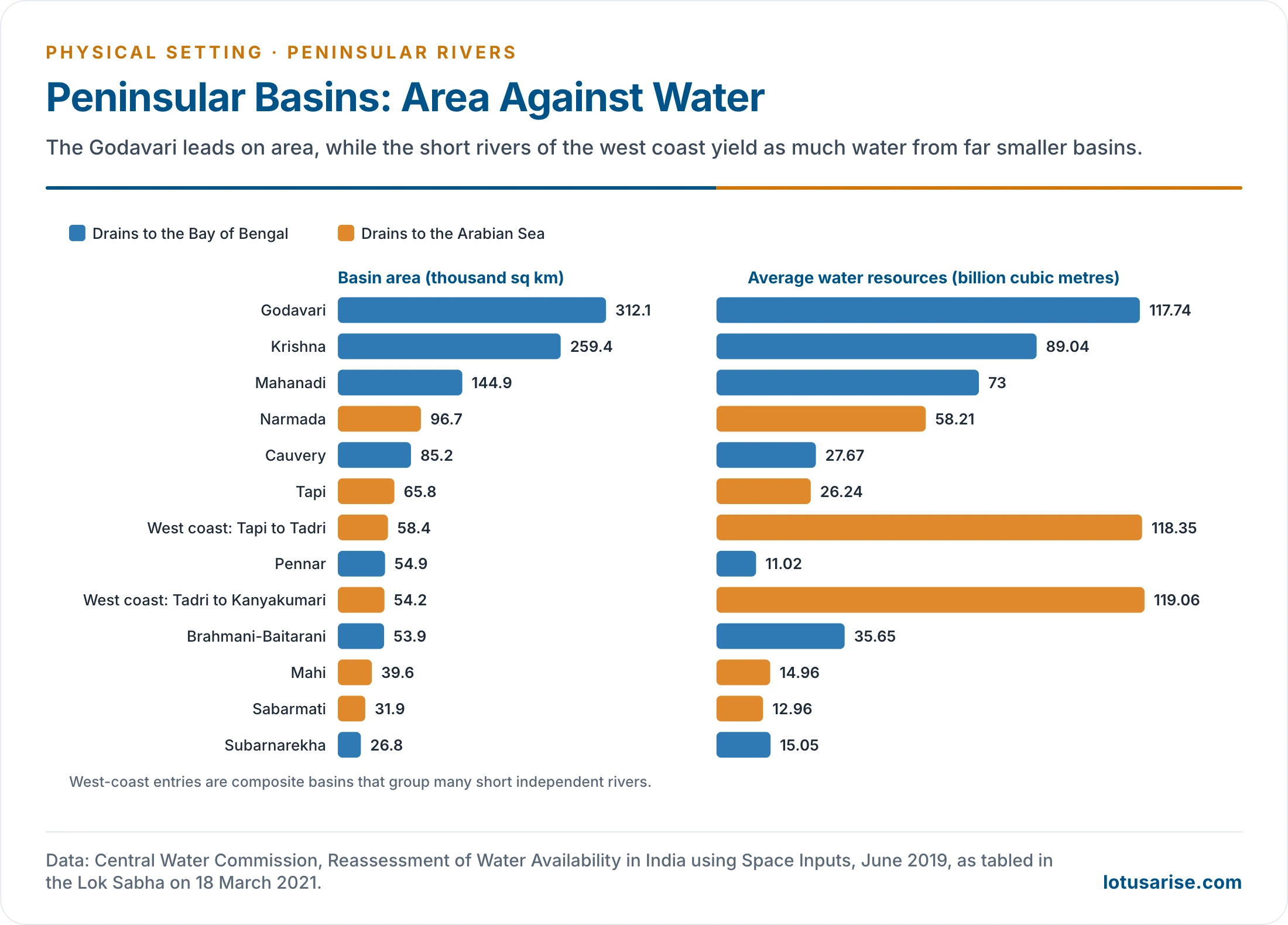
- Share of water: these basins cover only about 3% of the basin area of India.
- An older figure credits them with about 18% of the water. The 2019 CWC assessment gives about 3.4% of area and 11.9% of water: 237.41 of 1,999.2 billion cubic metres.
- Character: they flow swiftly down steep slopes, with falls and rapids, and enter the sea by estuaries.
- By State:
- Gujarat and Maharashtra: the Purna, Ambika, Damanganga, Vaitarna, Ulhas, Amba, Savitri and Vashishti.
- Goa: the Mandovi, Zuari and Rachol.
- Karnataka: the Kalinadi, Gangavali (Bedti), Sharavati, Tadri, Varahi and Netravati.
- Keralam (Kerala): the Valapattanam, Chaliyar (Beypore), Bharathapuzha, Periyar, Muvattupula, Pamba, Achankovil and Kallada.
- Jog or Gersoppa Falls: made by the Sharavati, it is India’s best-known waterfall.
- Older accounts give 289 m. The accepted height of the main drop is 253 m (830 ft).
- The Sharavati rises and flows entirely within Karnataka.
Ghaggar River: Inland Drainage
- Inland drainage: some Indian rivers cannot reach the sea.
- It covers much of the Rajasthan desert, as well as tracts of Aksai Chin in Ladakh.
- Ghaggar: the most important inland river, a seasonal stream rising on the lower Himalayan slopes and forming the Haryana–Punjab boundary.
- End: it disappears into the Rajasthan sands near Hanumangarh, having run 465 km.
- Past: it was once an affluent of the Indus, and the dry bed of the old channel can still be traced.
- Tributaries: the Tangri, Markanda, Saraswati and Chaitanya.
- Monsoon: it holds far more water in the rains, when its bed reaches 10 km wide at places.
- Aravalli streams: most streams on the western Aravalli slopes dry up as soon as they reach the sandy tracts to the west.
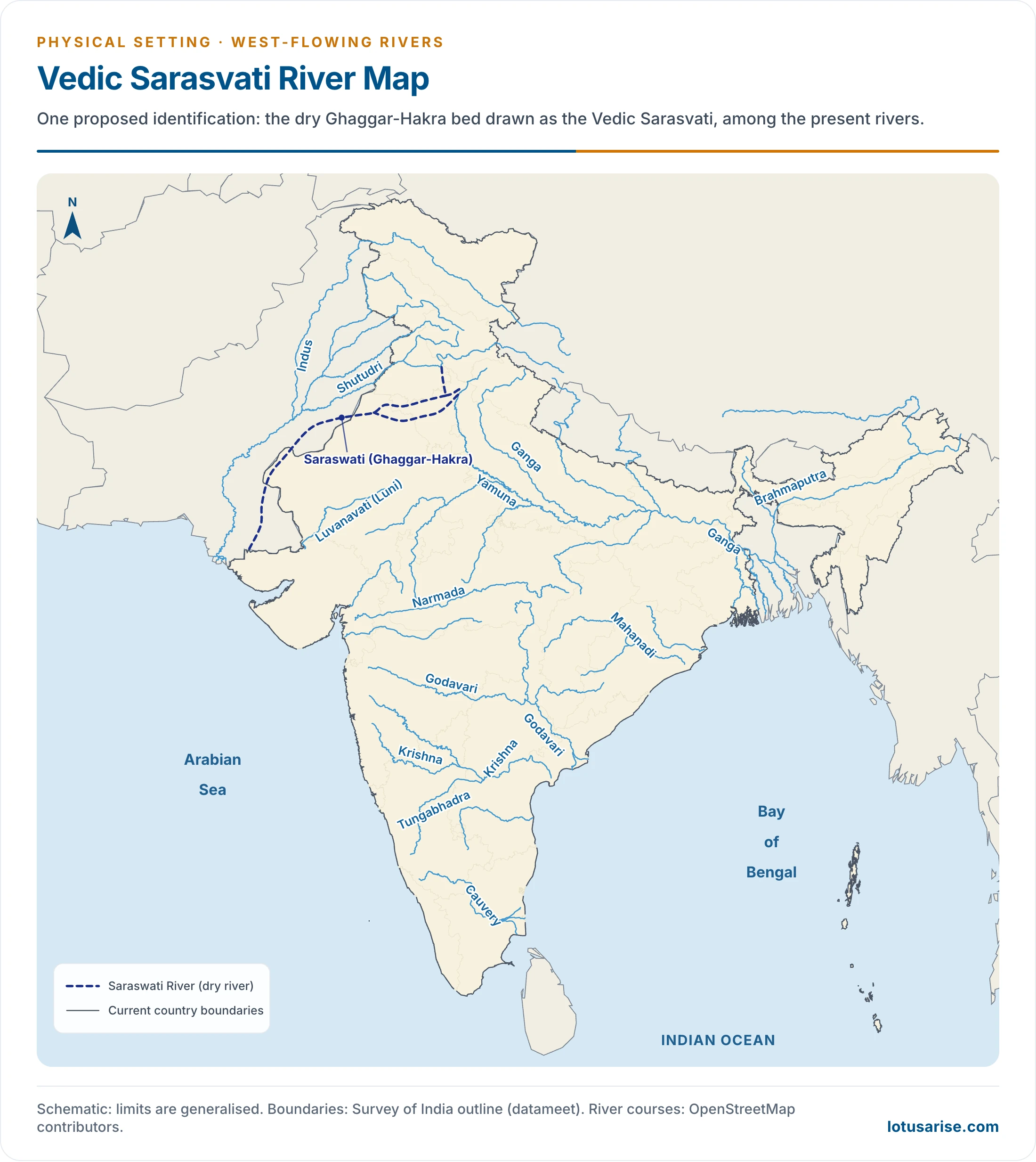
- The map follows one proposed identification of the dry Ghaggar–Hakra bed with the Vedic Sarasvati. This identification remains debated.
Mhadei River
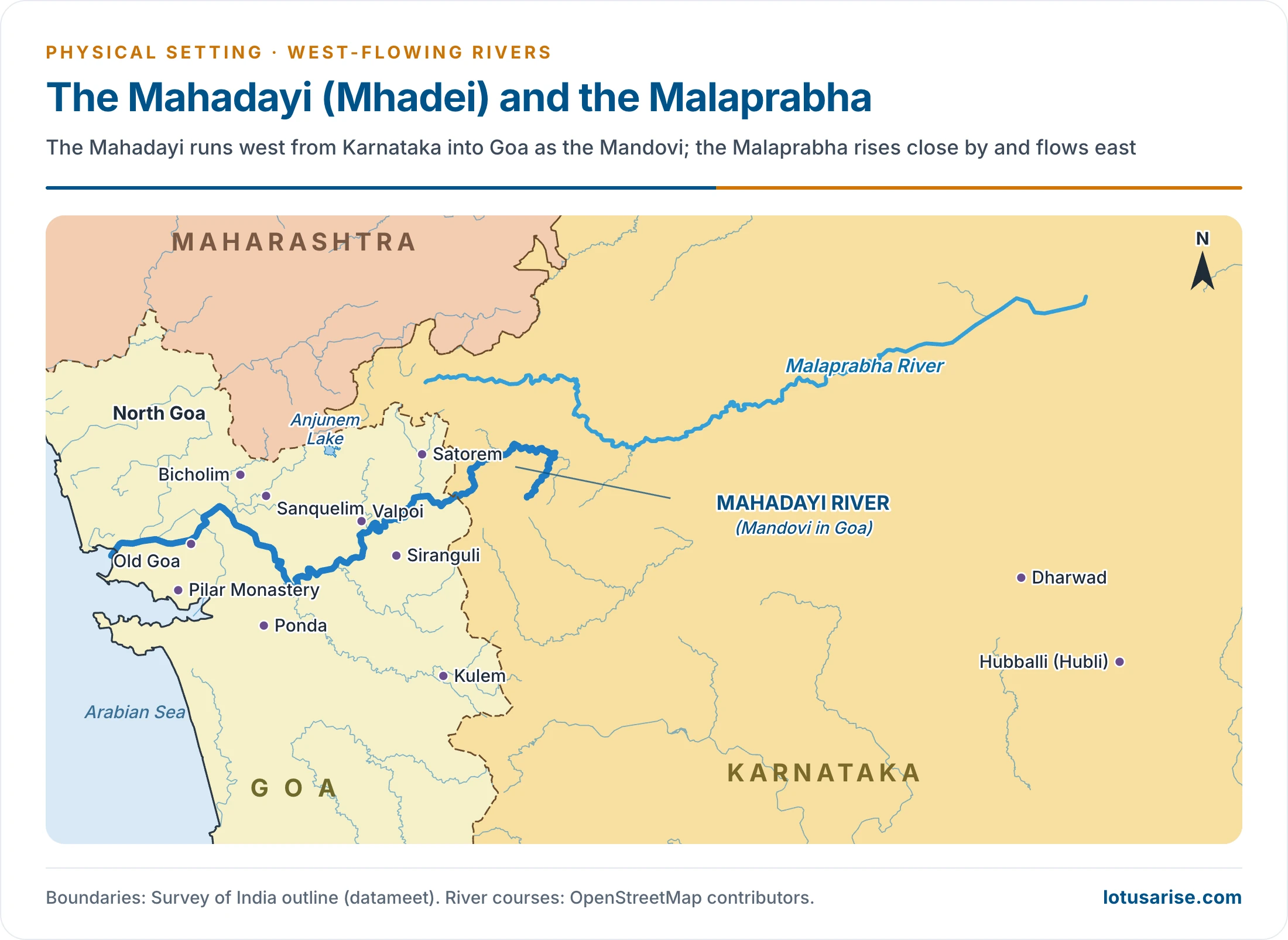
- Mahadayi or Mhadei, a west-flowing river, rises in Bhimgad Wildlife Sanctuary in the Western Ghats, in Belagavi district of Karnataka.
- It is rain-fed, and is called the Mandovi in Goa.
- Joined by many streams, it forms the Mandovi, one of two major rivers of Goa. The other is the Zuari.
- It travels 35 km in Karnataka and 82 km in Goa before reaching the Arabian Sea. Totals vary by source, with about 81 km and 87 km also given.
- Basin: 2,032 sq km, of which 375 sq km is in Karnataka, 77 sq km in Maharashtra and the rest in Goa.
- Dudhsagar Falls lie on the Goa stretch of the Mandovi system.
- Kalasa-Banduri Nala project: Karnataka’s scheme to improve drinking water in Belagavi, Dharwad and Gadag.
- It proposes works across the Kalasa and Banduri, two Mahadayi tributaries, to divert 7.56 TMC to the Malaprabha river.
- It was planned in 1989, and Goa objected.
- Tribunal award: the Mahadayi Water Disputes Tribunal decided on 14 August 2018, and the award was published on 27 February 2020.
- Goa 24 tmc, Karnataka 13.42 tmc, Maharashtra 1.33 tmc.
- Karnataka’s share includes 8.02 tmc for non-consumptive power. Diversion is limited to 3.9 tmc: 2.18 at Bandura and 1.72 at Kalasa, well below the 7.56 sought, and only after fresh appraisal and clearances.
- Further references by all three States and the Centre remain before the tribunal, whose time was extended by a year from August 2025.
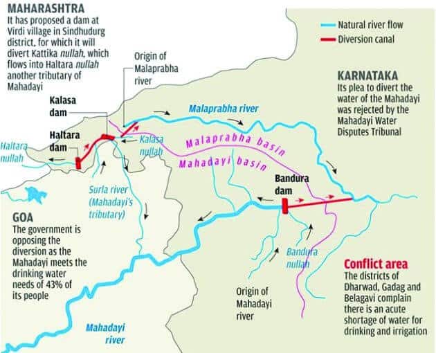
- This graphic’s line that Karnataka’s plea was rejected by the tribunal reflects an interim stage. The final award of 2018 allowed the limited diversion above.
Usability of Rivers
- Uses: fresh water, irrigation, hydro-electric production, navigation and more.
- Water power: the Himalayas, Vindhyas, Satpuras, Aravalis, Maikala, Chhotanagpur plateau, Meghalaya plateau, Purvachal and the Western and Eastern Ghats offer scope for large-scale development.
- Distribution of flow: in an older estimate, sixty percent of total river flow is in the Himalayan rivers and 16 percent in the Central Indian rivers such as the Narmada, Tapi and Mahanadi. The remainder belongs to the Deccan rivers.
- Peninsular power needs monsoon storage, whereas Himalayan flows persist in winter.
- Waterways: useful routes include the Ganga and Brahmaputra of the north and north-east, Odisha’s Mahanadi, the Godavari and Krishna of Andhra and Telangana, Gujarat’s Narmada and Tapi, and the lakes and tidal creeks of coastal States.
- They mattered greatly in the past, but suffered with the advent of rail and road.
- Heavy withdrawal for irrigation has reduced flow in many rivers.
- Navigability: the Ganga, Brahmaputra and Mahanadi are the most important navigable rivers. The Godavari, Krishna, Narmada and Tapi are navigable near their mouths only.
Previous Year Questions
2026Map item: Mahi Basin2019Present the salient features of the west-flowing rivers of India.2017Map item: Luni River2017Map item: Dudhsagar Waterfalls2016Map item: Jog Falls





Great Compailation..Sir Please provide Economic & History notes also
Yeah Sure, will do
if possible please provide commerce and accountancy optional notes
REALLY HELPFULL
the numerical % of narmada basin in indian states is missing here…but still is content is far better than all other sites
Great content, it would be better if you could add the southern rivers flowing into the west.