

- Roman geography grew out of the needs of a vast empire: roads, surveys, censuses, itineraries and maps for soldiers, governors and traders. Its greatest works were written by Greek scholars living under Roman rule, above all Strabo and Claudius Ptolemy.
- Rome added practical, administrative and regional knowledge to the theoretical frame it inherited from Greek scholars.
- Ancient Chinese geography developed in parallel and almost wholly apart from the Mediterranean world. It was empirical, state-centred and cartographic, with an unbroken tradition of regional surveys, gazetteers and grid maps from the Yu Gong to the Ming travellers.
- Together they show two answers to one problem: how a large state knows and governs its territory, and how scholars widen the known world beyond its frontiers.
Roman Geography

The Roman Context
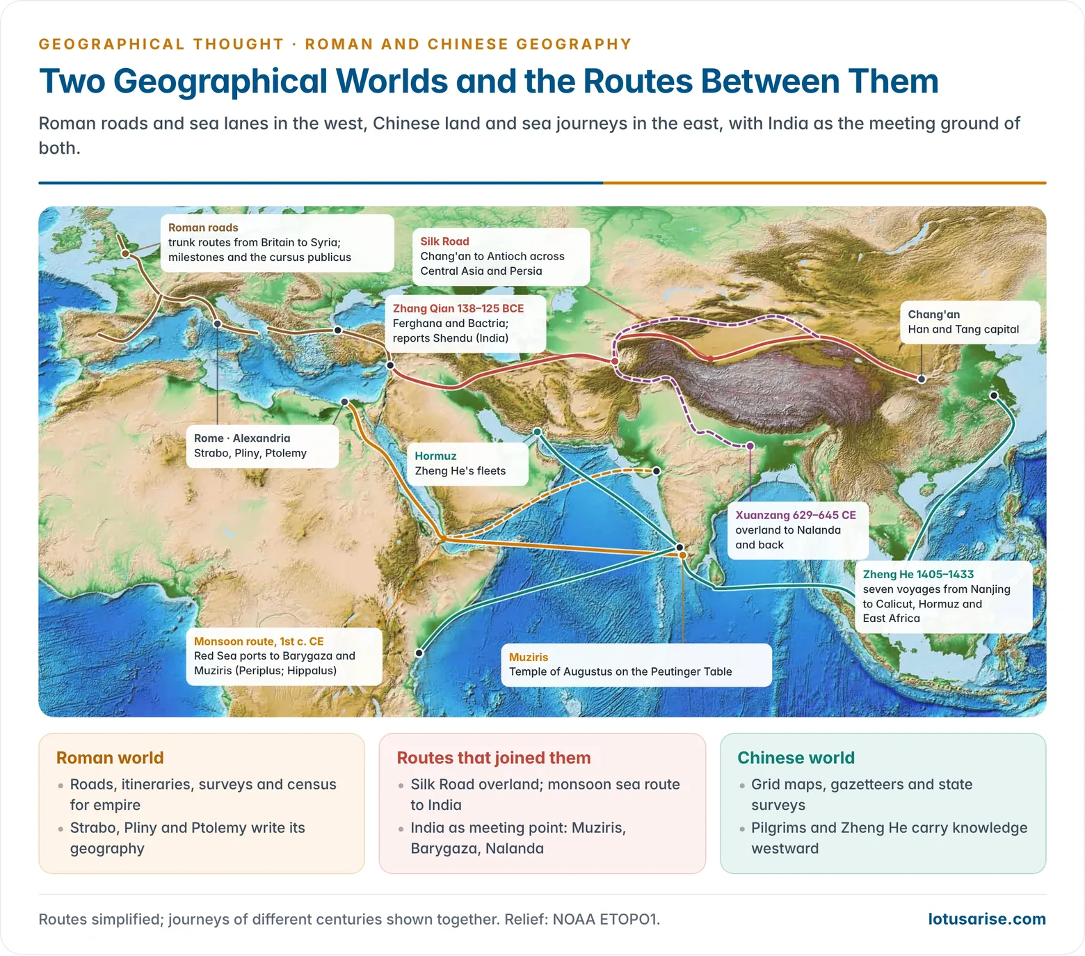
- Political setting: from the 2nd century BCE Rome absorbed the Hellenistic world. By the Augustan age (27 BCE–14 CE) the known world reached from Britain and the Atlantic to the Indus, and from the Rhine and Danube to the Sahara.
- The Romans themselves wrote little original theory. Their contribution lay in regional, historical, political and applied geography.
- Roads: an empire-wide network of over 400,000 km of roads, more than 80,000 km of them stone-paved, with 29 military highways radiating from Rome.
- Milestones gave distances, and Augustus set up the Golden Milestone (miliarium aureum, 20 BCE) in the Forum as the symbolic zero point.
- The cursus publicus (state post) relayed officials and messages along the roads.
- Itineraries: lists of stations and distances along routes. The Antonine Itinerary (compiled under the Antonine emperors, 2nd–3rd century CE) was the traveller’s road book of the empire.
- Land survey: surveyors (agrimensores, gromatici) used the groma, a cross-staff for setting right angles, to lay out roads, camps, towns and the square field grids of centuriation. These grids still show in the landscape of the Po plain and North Africa.
- Census and administration: the provincial census and tax registers required detailed knowledge of land, people and resources in each province.
- Agrippa’s world map: Marcus Vipsanius Agrippa (d. 12 BCE) compiled distance data for a great world map displayed in a public portico in Rome, an official image of the empire’s reach.
- Varro’s culture stages: Marcus Terentius Varro (116–27 BCE) described human society as passing from gathering, through pastoral nomadism and agriculture, to settled civilisation. This sequence went almost unchallenged until the 19th century.
The Peutinger Table
- The Tabula Peutingeriana is a parchment copy, made around 1200, of a late Roman road map last revised in the 4th or early 5th century CE.
- It is a strip about 6.75 m long and 34 cm high, in 11 surviving sheets, showing the road network of the cursus publicus from western Europe through Persia to India and Sri Lanka.
- It marks some 555 cities and about 3,500 other place names, with distances between stations, plus rivers, mountains and forests.
- It does not attempt true shape: land and sea are stretched east–west to fit the strip. It is a topological diagram of routes, like a modern metro map.
- India on the map: it shows Muziris on the Malabar coast with a Temple of Augustus, evidence of Roman merchants settled in Kerala.
- It is held in the Austrian National Library, Vienna, and was entered in UNESCO’s Memory of the World Register in 2007.
Polybius
- Polybius (c. 200–c. 118 BCE), a Greek statesman taken to Rome as a hostage, wrote the Histories of Rome’s rise. One of its 40 books was devoted to geography.
- He insisted on personal observation (autopsy) and travelled along the Atlantic coast of Africa with Scipio and across the Alps to check Hannibal’s route.
- He saw geography as the setting that explains military and political events, carrying forward the historical tradition of Herodotus.
Strabo
- Strabo (c. 64 BCE–c. 24 CE) was born at Amaseia in Pontus (northern Turkey), studied in Asia Minor and Rome, and travelled from Armenia to Etruria and from the Black Sea to Syene and the borders of Ethiopia, sailing up the Nile in about 25–24 BCE.
- His Geographica in 17 books is the only large geographical work of antiquity to survive almost complete. Much of what is known of Eratosthenes, Hipparchus, Posidonius and Polybius survives only through its quotations.
| Books | Content |
|---|---|
| 1–2 | History and principles of geography from Homer to Posidonius; shape and size of the earth and the ecumene |
| 3–10 | Europe: Iberia, Gaul, Britain, the Alps, Italy, Sicily, central Europe, Greece |
| 11–16 | Asia: Caucasus and Caspian, Asia Minor, Persia, India, Mesopotamia, Syria, Arabia |
| 17 | Africa: mainly Egypt, Ethiopia and Libya |
Method and Purpose
- Purpose: a handbook for statesmen, generals and administrators of the empire, not for specialists. Geography is useful knowledge for governing.
- Division of labour: the geographer takes the earth’s shape and size from the astronomer and mathematician, then describes the inhabited world as a whole and, after that, its parts, land and sea, correcting earlier authorities where needed.
- Natural regions: he preferred to divide lands by natural boundaries (mountains, rivers, seas) rather than shifting political borders.
- Chorology: his regional description of places, peoples, customs, products and governments makes him the classic model of chorological (regional) writing and of areal differentiation. He is often called the father of regional geography.
- History and geography together: each region’s past is explained through its setting, in the line of Herodotus.
Contributions
- Political geography: he explained Italy’s rise by its central position in the Mediterranean, temperate and varied climate, protective Alps and sea, good harbours and mixed resources. He judged a strong central government necessary for a large empire.
- This joins ethnocentrism with an early environmental determinism.
- Physical geography:
- He described Vesuvius as an extinct “burning mountain” with fertile ash soils, a century before its eruption of 79 CE, and the volcanic islands near Naples and Sicily.
- He discussed uplift and subsidence of land, the rise and fall of the sea, and earthquakes.
- He argued that large changes should be inferred from small changes observed at present. Charles Lyell, the 19th-century geologist, praised this as an anticipation of his own principle.
- He correctly attributed the Nile floods to summer rains in the Ethiopian highlands.
- India: relying on Alexander’s officers, Nearchus and Megasthenes, he described the Ganges rising in the Himalaya (Emodus) and flowing past Palibothra (Pataliputra) to the eastern sea, and the monsoon rains and two harvests of the plains.
- Errors and limits:
- He took the Caspian for a gulf of the northern Ocean and put Ireland north of Britain.
- He dismissed Herodotus and Pytheas as storytellers.
- He set the habitable limit near 12°30′ N and adopted Posidonius’ smaller earth.
- He gave little attention to mathematical geography.
Pomponius Mela
- Pomponius Mela, from Tingentera near Algeciras in southern Spain, wrote De Chorographia (also called De situ orbis) in three books around 43 CE. It is the earliest surviving geography in Latin.
- It follows the coasts in the manner of a periplus, from the Strait of Gibraltar round the Mediterranean and then the outer Ocean.
- It divided the earth into five zones, of which two were habitable, and held that unknown people, the Antichthones, lived in the southern temperate zone, cut off by the torrid zone.
- It stayed in use until about 1500.
Pliny the Elder
- Pliny the Elder (23–79 CE), naval commander and encyclopaedist, compiled the Naturalis Historia in 37 books (dedicated 77 CE). He claimed some 20,000 facts from about 2,000 books.
- Books 3–6 are geographical: Iberia and Italy, Europe, Africa and Asia, and the East, including India and Taprobane.
- Other books cover the cosmos, climate, plants, animals, minerals and their uses.
- Strengths: a vast inventory of places, resources and products, the basis of medieval European knowledge of the world.
- Limits: uncritical compilation, mixing fact with marvels.
- India: he described the monsoon voyage from Egypt to Muziris and complained of Rome’s drain of coin for Eastern luxuries such as pepper.
- He died in 79 CE while observing the eruption of Vesuvius at close range.
Trade Geography: The Periplus and India
- The Periplus of the Erythraean Sea (mid-1st century CE), written in Greek by an unknown merchant in Roman Egypt, is a practical guide to ports, goods and winds from the Red Sea to East Africa and India.
- Indian ports it describes include Barygaza (Bharuch), a major outlet for the trade of western India, and Muziris and Nelcynda on the Malabar coast.
- Exports were pepper, cotton cloth, gems, ivory and spices, paid for in Roman gold and silver, wine and glass.
- Using the south-west monsoon (credited by Greek writers to the pilot Hippalus), ships crossed the open Arabian Sea directly instead of hugging the coast.
- Archaeology confirms the trade: Roman coins in south India, the Indo-Roman port at Arikamedu near Puducherry, excavated by Mortimer Wheeler (1945), and excavations at Pattanam in Kerala, linked with ancient Muziris.
Tacitus and Regional Ethnography
- Tacitus’ Germania (98 CE) described the tribes beyond the Rhine and Danube: their land, ways of life, institutions and character. It is a model of regional ethnography, coloured by Roman moral comparison.
Claudius Ptolemy
- Claudius Ptolemy (c. 100–c. 170 CE), a Greek astronomer and mathematician of Alexandria in Roman Egypt, brought the mathematical tradition to its height.
- Almagest (c. 150 CE): an Earth-centred astronomy using epicycles and a catalogue of over 1,000 stars. It remained the standard work until Copernicus (1543).
- Geography (Geographike Hyphegesis, c. 150 CE), in eight books:
- Book 1: method and sources, a revision of the lost atlas of Marinus of Tyre, and instructions for map projection.
- Books 2–7: a gazetteer of some 8,000 places with latitude and longitude in degrees.
- Book 8: the plan of regional maps with notes on day length.
- Definitions: geography draws the whole known world to scale, like a portrait of the whole head. Chorography describes parts in detail, like an eye or an ear.
- This is the first clear statement of the general versus special distinction that runs through later dualisms.
Cartographic Achievements
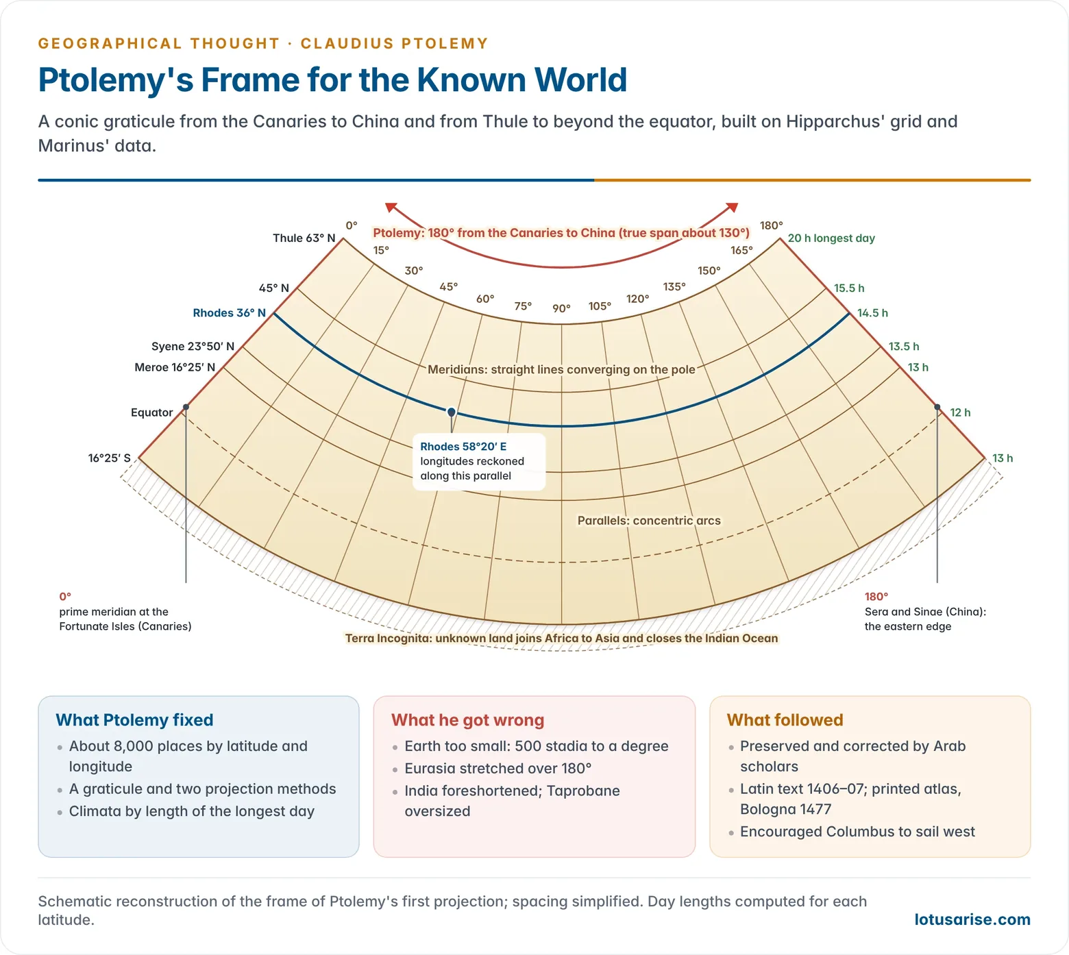
- Graticule: every place is fixed on a grid of parallels and meridians, with the circle in 360°, following Hipparchus.
- Projections: he set out methods for drawing the curved earth on a flat sheet.
- In his simple conic projection, parallels are concentric arcs and meridians are straight lines converging towards the pole.
- In a modified version, the meridians are also curved, reducing distortion.
- Reference lines:
- The prime meridian passed through the Fortunate Isles (Canaries), the western edge of the known world.
- Longitudes were reckoned along the parallel of Rhodes (36° N).
- Climata: belts of latitude defined by the length of the longest day, at quarter-hour steps up to the latitude where the longest day is 15½ hours, and half-hour steps beyond.
- Range: the map ran from Thule (63° N) to south of the equator, and 180° of longitude from the Canaries to Sera and Sinae (China).
- New features included the Bay of Bengal (Gangetic Gulf), the Malay Peninsula (Golden Chersonese), the Volga flowing into an enclosed Caspian, and the Nile rising in lakes fed by the snowy Mountains of the Moon in East Africa.
Errors
- Smaller earth: he adopted Posidonius’ circumference of 180,000 stadia, giving 500 stadia to a degree instead of about 700, and stretched Eurasia over 180° of longitude instead of about 130°.
- This error shrank the Atlantic gap between Europe and Asia and later encouraged Christopher Columbus to sail west.
- Closed Indian Ocean: an unknown southern land (Terra Incognita) joined Africa to East Asia and enclosed the Indian Ocean.
- India: the peninsula is foreshortened into a short coast running east–west, while Taprobane (Sri Lanka) is drawn many times its true size and extended south of the equator.
- Sources: most positions came from travellers’ estimates of distance, not astronomical fixes, so each coordinate was a best guess.
- He accepted Aristotle’s view that the torrid zone was largely uninhabitable.
Legacy
- The Geography passed to the Arab geographers, who corrected and extended it.
- Maximus Planudes recovered a Greek copy in Byzantium (c. 1295). Jacobus Angelus translated it into Latin in Florence (1406–07), and the first printed edition with engraved maps appeared at Bologna in 1477.
- Ptolemaic maps shaped the Age of Exploration until new voyages overturned them. His grid and projections remain the foundations of scientific cartography.
The Close of the Classical Tradition
- After Ptolemy, Roman geography became compilation. Gaius Julius Solinus (3rd century CE) collected marvels largely from Pliny.
- As the Western Empire fell (476 CE), Christian writers placed scripture above observation.
- Cosmas Indicopleustes, a merchant who had sailed to India and Sri Lanka, described a flat, box-shaped world in his Christian Topography (c. 550).
- Symbolic T-in-O maps, with Jerusalem at the centre, replaced the graticule. Classical learning survived mainly through Byzantium and the Arabs.
Ancient Chinese Geography
Context and Outlook
- Chinese geography grew in the Wei and Huang He (Yellow River) valleys and served a centralised bureaucratic state. It was used to collect tribute and taxes, control floods and canals, defend frontiers and govern distant provinces.
- The Han census of 2 CE counted about 57.7 million people, the oldest surviving national census.
- World view: humans are part of nature, with no creator who designed the world for human use.
- Chinese thought was therefore less teleological than the Greek, and more concerned with observable things and processes than with abstract theory.
- Cosmology: an old belief in a round heaven and square earth gave way by the 2nd century CE to three schools:
- Gaitian: heaven as a dome over the earth.
- Huntian: a celestial sphere round the earth, like an egg round its yolk.
- Xuanye: bodies floating in infinite empty space.
- Technical base: paper (Han period), printing, the magnetic compass, rain and snow gauges, systematic records of eclipses, comets and floods, and measurement of the silt load of rivers.
Early Geographical Texts
- Yu Gong (“Tribute of Yu”), a chapter of the Shujing (Book of Documents), probably from the 5th–3rd century BCE, is the oldest Chinese geographical text.
- It divides China into nine provinces (jiuzhou). For each it lists soils, products, tribute and waterways, credited to the legendary flood-tamer Yu the Great.
- It is an early regional survey of resources, centuries before Strabo.
- Shanhaijing (“Classic of Mountains and Seas”, compiled from about the 4th century BCE) mixes routes, mountains, rivers and minerals with myth and strange peoples.
- Mencius (4th century BCE) described Ox Mountain near the Qi capital, stripped of forest by cutting and grazing so that it could no longer regrow. It is an early account of human-caused land degradation, comparable to Plato on Attica.
- Regional writing later grew into a great genre:
- Accounts of foreign peoples and tribute-bearers.
- Waterway classics, above all Li Daoyuan’s Shui Jing Zhu (Commentary on the Water Classic, early 6th century), describing over 1,000 rivers.
- Local gazetteers (difangzhi) for provinces and counties, which grew into thousands of volumes.
- Geographical encyclopaedias in a style close to Strabo’s.
Explorers and Pilgrims
- Zhang Qian, sent west by the Han emperor Wu in 138 BCE to seek allies against the Xiongnu, was held captive by the Xiongnu for years and returned only around 125 BCE.
- He brought the first Chinese reports of Ferghana (Dayuan), Sogdiana, Bactria (Daxia) and Parthia.
- In Bactria he saw goods from southern China that had come by way of Shendu (India), a hot, humid land on a great river where people fought from elephants. The name Shendu derives from Sanskrit Sindhu.
- His missions opened the overland Silk Road, the main link between the Han and Roman worlds.
- Buddhist pilgrims to India wrote some of the most valuable regional geographies of the subcontinent:
- Faxian travelled overland to India and returned by sea via Sri Lanka (c. 399–412 CE).
- Xuanzang spent some sixteen years (629–645 CE) travelling across Central Asia and India, studying at Nalanda. His Great Tang Records on the Western Regions (646 CE) describes some 138 countries and regions.
- Yijing reached India by sea through Sumatra (late 7th century).
Zhang Heng and Pei Xiu: Scientific Cartography
- Zhang Heng (78–139 CE), Chief Astronomer of the Han court:
- In 132 CE he built the first seismoscope: a bronze vessel with eight dragon heads around it. A shock released a ball from the dragon facing the quake’s direction into the mouth of a bronze toad. It is said to have detected an earthquake in Longxi, several hundred kilometres away, before any messenger arrived.
- He built a water-powered armillary sphere and catalogued about 2,500 stars.
- He presented a map of the land (116 CE). He is often credited with introducing a rectangular grid to Chinese maps, though the evidence is thin.
- Pei Xiu (224–271 CE), Minister of Works under the Jin dynasty, is called the father of Chinese cartography.
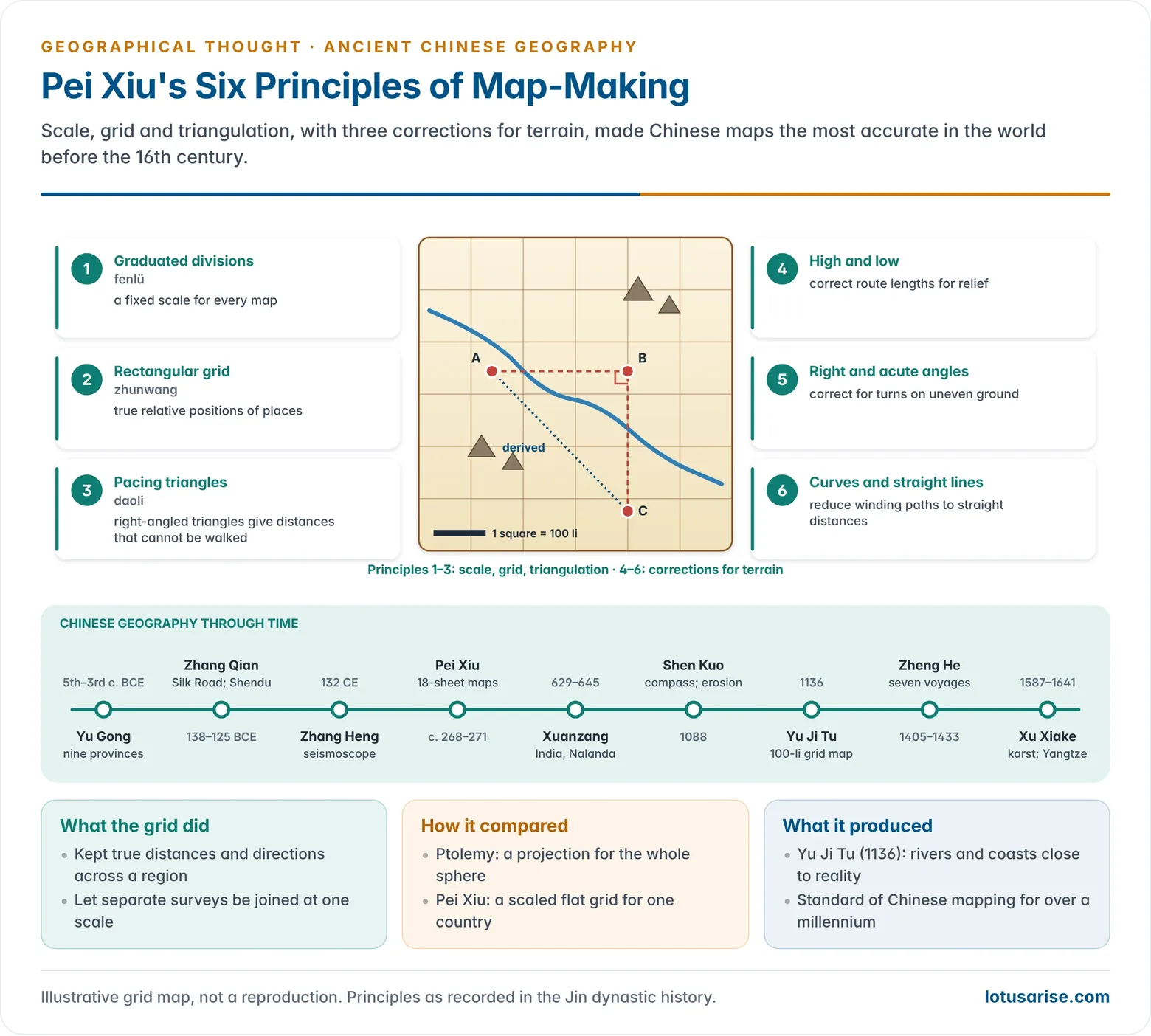
- He prepared a set of regional maps of China in 18 sheets, based on the Yu Gong provinces, and criticised earlier maps that had no scale or grid.
- Six principles of map-making:
- Graduated divisions (fenlü): a fixed scale.
- Rectangular grid (zhunwang): correct relative positions.
- Pacing the sides of right-angled triangles (daoli): deriving distances that cannot be walked directly.
- Measuring the high and the low.
- Measuring right and acute angles.
- Measuring curves and straight lines.
- The last three adjust route distances for relief and winding paths to true horizontal distances.
- These rules combined scale, grid and triangulation, and set the standard of Chinese mapping for over a thousand years.
- Later grid maps:
- The Yu Ji Tu (“Map of the Tracks of Yu”), carved in stone in 1136 and now in the Forest of Steles at Xi’an, has a grid of 5,110 squares of 100 li each. Its rivers and coasts are far more accurate than any European map of the time.
- Zhu Siben’s map of China (c. 1311–1320) drew on the Mongol unification of Asia. Chinese and Korean maps derived from it showed Africa as a south-pointing triangle.
Shen Kuo
- Shen Kuo (1031–1095), a Song official, astronomer and engineer, recorded his observations in the Dream Pool Essays (1088).
- Compass: the first clear description of the magnetic needle compass and of magnetic declination, the needle pointing slightly east of true south.
- Geomorphology:
- Marine shells in cliffs of the Taihang Mountains showed him that an old shoreline had shifted hundreds of kilometres east.
- He explained the land as built by erosion of mountains and deposition of silt.
- He described the sharp peaks of the Yandang Mountains as left standing by running-water erosion.
- Climate change: petrified bamboo found deep underground near Yan’an, where bamboo no longer grows, led him to infer that the climate had changed.
- Cartography: he made raised-relief maps of wood and wax, and an atlas of 23 maps at a uniform scale.
Zheng He’s Voyages
- Zheng He (1371–1433/35), a Ming admiral, led seven voyages (1405–1433) with fleets of large “treasure ships” and tens of thousands of men.
- Calls included Champa, Java, Sumatra, Sri Lanka, Calicut (a regular base on every voyage), Hormuz, Aden, the Red Sea and the East African coast (Mogadishu and Malindi).
- The voyages produced navigation charts (preserved in the Wubei Zhi), and accounts of ports, products and peoples by officers such as Ma Huan.
- After 1433 the Ming court ended state voyaging, just decades before the Portuguese reached India (1498).
Xu Xiake
- Xu Xiake (1587–1641), a Ming traveller, spent over thirty years on foot recording landscapes in The Travel Diaries of Xu Xiake (about 400,000 characters).
- He gave detailed, measured descriptions of the limestone (karst) landscapes and caves of Guangxi, Guizhou and Yunnan, among the earliest systematic karst studies anywhere.
- He showed that the Jinsha River is the true headwater of the Yangtze, correcting the Yu Gong, and that the Mekong and Salween are separate rivers.
- His field method reads like modern survey work.
Evaluation of the Chinese Tradition
- Strengths:
- Continuous, empirical record-keeping.
- The world’s most advanced cartography before the 16th century.
- Rich regional and gazetteer writing.
- Early insight into erosion, deposition, climate change and human impact on land.
- Limits:
- Sino-centric: the world was seen as tianxia (“all under heaven”) ringed by tributary peoples.
- Grid maps were not projections, so they could not handle the earth’s curvature. Ideas of a flat earth persisted.
- Little theory-building, and almost no exchange with Greek or Arab science.
- The received history of geography long ignored this tradition. Joseph Needham’s Science and Civilisation in China (from 1954) restored it, part of the wider challenge to Eurocentrism in geographical thought.
Roman and Chinese Geography Compared
| Feature | Roman world | Ancient China |
|---|---|---|
| Driving need | Empire, roads, trade, administration | Bureaucratic state, tribute, floods, frontiers |
| Key figures | Polybius, Strabo, Mela, Pliny, Ptolemy | Zhang Qian, Zhang Heng, Pei Xiu, Shen Kuo, Zheng He, Xu Xiake |
| Main genres | Regional treatise, encyclopaedia, itinerary, periplus | Regional survey, gazetteer, water classic, travel record |
| Mapping | Graticule and projection (Ptolemy); route diagrams (Peutinger) | Scaled rectangular grid and triangulation (Pei Xiu) |
| Earth’s shape | Spherical; measured | Mostly flat or square earth; sphere in huntian astronomy |
| Outlook | Teleology and determinism; Italy at the centre | Organic, non-teleological; China at the centre |
| Physical geography | Volcanoes, uplift, Nile floods (Strabo) | Erosion, old shorelines, climate change (Shen Kuo); karst (Xu Xiake) |
| Contact with India | Monsoon trade to Muziris and Barygaza; Periplus | Zhang Qian’s Shendu; Faxian and Xuanzang; Zheng He at Calicut |
| Legacy | Passed through Arabs to Renaissance Europe | Long unknown in the West; revived by modern scholarship |
- Common ground: both traditions served the state, joined description with measurement, wrote regional geography of their known worlds, and placed their own civilisation at the centre.
- Difference: Rome inherited a theory of the spherical earth and built the graticule; China built accurate, scaled maps of its own territory without that theory. Each was strongest where the other was weakest.
Previous Year Questions
- No direct PYQ has been asked on this sub-topic yet.




