

- Spatial organisation is the way people and their activities, such as settlements, farms, factories, markets, routes and flows, are arranged and linked across the earth’s surface. It also covers the processes that produce that arrangement.
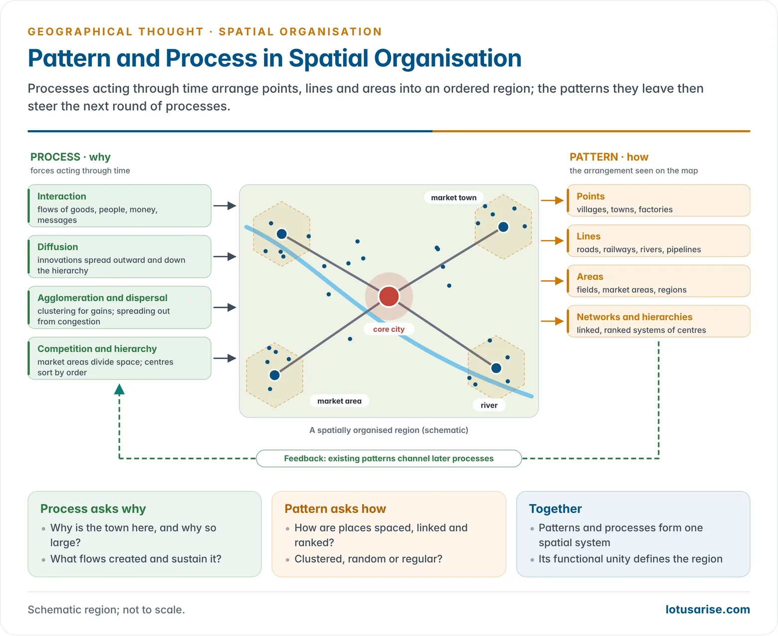
- It treats geography as the study of pattern and process. Pattern is the visible form of an arrangement, its how. Process is the force acting through time that produced it, its why.
- The idea became central with the quantitative revolution. Edward J. Taaffe (1970), reporting on the state of American geography, described the discipline as the study of spatial organisation expressed as patterns and processes.
- It complements the older tradition of areal differentiation. That tradition asks how places differ; spatial organisation asks how places are connected and ordered.
Meaning and Development

From Areal Differentiation to Spatial Organisation
- Areal differentiation (chorology): the earth’s surface is divided into unique regions, each with internal homogeneity and external heterogeneity. This tradition led to the regional approach.
- Spatial organisation: asks why phenomena are arranged as they are and how places interact and function together. It leans toward the systematic approach, with its search for general patterns, models and laws.
- Fred K. Schaefer (1953) defined geography as the science of spatial arrangements. His call for laws of pattern made spatial organisation the organising idea of the new geography.
- This difference of emphasis fed the regional versus systematic geography debate.
- In practice the two meet. A region is itself a spatially organised unit, held together by functional linkages between a core and its hinterland.
- Landmark works:
- Peter Haggett’s Locational Analysis in Human Geography (1965) set out a geometry of movement, networks, nodes, hierarchies, surfaces and diffusion.
- Richard Morrill’s The Spatial Organization of Society (1970) argued that people seek maximum interaction at minimum cost, which produces similar location patterns in very different societies.
- Ronald Abler, John S. Adams and Peter Gould’s Spatial Organization: The Geographer’s View of the World (1971) presented the whole discipline through spatial questions: measurement and classification, location and interaction, diffusion, and decision processes.
Pattern and Process
- Pattern (form): the arrangement seen on a map, of points (villages, towns), lines (roads, rivers, railways) and areas (fields, market areas, regions).
- Patterns may be clustered, random or regular, and dense or sparse. Hierarchies and networks are also patterns.
- Example: rural settlements are compact and nucleated on the fertile, densely settled Gangetic plain. They are dispersed in hamlets in the hills of the North-East, the Western Ghats and the Himalaya, where slope, water and land are scattered.
- Nearest-neighbour analysis measures such contrasts and turns visual impressions into comparable numbers.
- Process (time): the forces that create and change patterns, such as migration, trade, competition, diffusion of innovations and investment.
- Interplay: processes create patterns, and existing patterns channel later processes.
- A new railway, for example, concentrates trade at its stations. The stations then attract further investment.
- Spatial synthesis: the many arrangements, interactions and linkages in an area combine into a functional whole. That whole gives a region its unity and its distinctive spatial expression.
- The geographer’s task: to find order in the apparent chaos of the earth’s surface by decoding the logic that underlies spatial arrangements.
Elements of Spatial Organisation
The Core Concepts
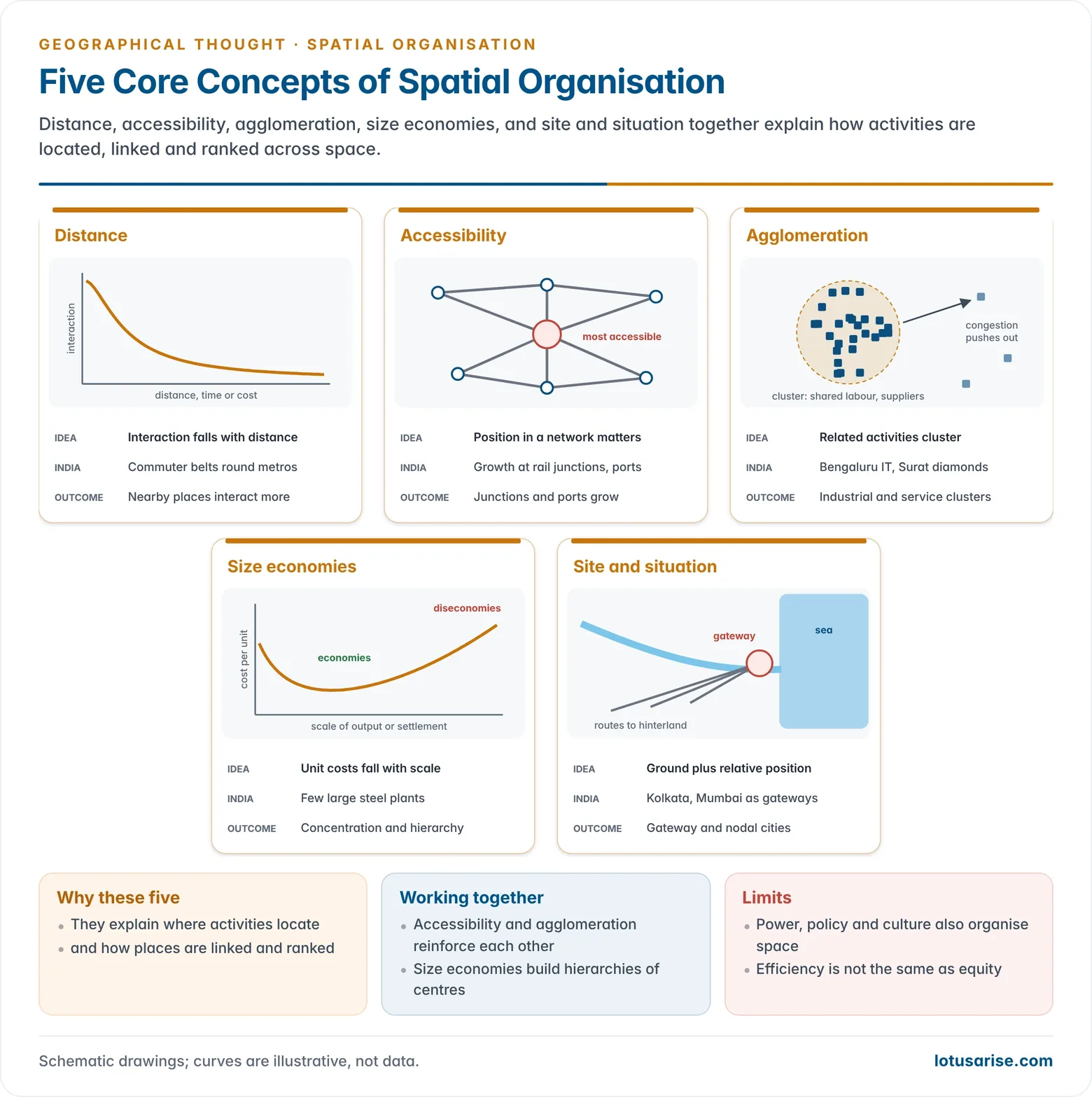
- Distance: the basic friction of space. It is measured not only in kilometres but in time, cost and effort. Interaction declines with distance (distance decay).
- People try to minimise the total distance they must overcome. George Kingsley Zipf’s principle of least effort (1949) states this.
- Accessibility: the ease of reaching a place from others. It depends on position within networks, not only on distance.
- Highly accessible places, such as route junctions, ports and capitals, attract activities and grow.
- New transport lowers the time needed between places. Donald Janelle (1968) called this time-space convergence.
- Agglomeration: related activities cluster to share markets, labour, suppliers and ideas.
- The gains are agglomeration economies. Too much clustering brings diseconomies such as congestion, high rents and pollution, which push activities outward (deglomeration).
- Examples: Bengaluru’s IT cluster, Surat’s diamond cutting and polishing, and Tiruppur’s knitwear industry.
- Size economies (economies of scale): larger plants, markets and cities lower the cost per unit. This favours concentration at a few large centres and gives rise to settlement hierarchies.
- Example: integrated steel plants and large refineries are built at a few big sites, not scattered widely.
- Site and situation (relative location): site is the physical character of the ground itself, such as a levee, a river crossing or a defensible hill. Situation is a place’s position relative to other places, routes and resources.
- Situation often matters more. Kolkata grew on the Hooghly levee as the gateway to the Ganga basin. Mumbai grew on its island harbour as the gateway to western India.
- Interaction and complementarity: flows arise where one place has a surplus that another demands.
- Edward Ullman (1956) listed three bases of interaction: complementarity, intervening opportunity and transferability.
| Concept | Core idea | Spatial outcome | Indian example |
|---|---|---|---|
| Distance | Friction of space; decay of interaction | Nearby places interact more | Commuter belts round metros |
| Accessibility | Position in networks | Growth at junctions and ports | Itarsi and Pt. Deen Dayal Upadhyaya (Mughalsarai) junctions |
| Agglomeration | Gains from clustering | Industrial and service clusters | Bengaluru IT, Surat diamonds |
| Size economies | Lower unit cost at scale | Concentration and hierarchy | Integrated steel plants |
| Site and situation | Physical ground and relative position | Gateway and nodal cities | Kolkata, Mumbai |
Spatial Processes
- Spatial interaction: the movement of goods, people, money and information. Such flows give functional unity to a region.
- Diffusion: the spread of innovations, diseases or ideas outward, either contagiously or down the urban hierarchy. Torsten Hägerstrand’s work made this a central process.
- Concentration and dispersal:
- Centralisation gathers activities at a core.
- Decentralisation and suburbanisation spread them outward when the core becomes congested.
- Time-space convergence and divergence: faster transport draws connected places closer in travel time. Places left off the new networks fall relatively further away, which widens regional disparities.
- Hierarchy formation: central places sort into orders by the range and threshold of the goods and services they offer, as in Walter Christaller’s model.
- Specialisation and competition: places specialise in what they do most cheaply. Firms compete for market areas, which divides space into hinterlands.
Spatial Organisation in Practice
Models of Spatial Organisation
- Rural land use: von Thünen’s rings of land use around a market.
- Urban structure:
- Ernest Burgess’s concentric zones (1925);
- Homer Hoyt’s sectors (1939);
- Chauncy Harris and Edward Ullman’s multiple nuclei (1945).
- Settlement systems: central place theory, the rank-size rule and the primate city.
- Regional development: John Friedmann’s core–periphery model (1966). Power, capital and innovation concentrate in a dominant core, while the periphery depends on it.
- Territory: Robert Sack (1986) described territoriality as the spatial organisation of people and groups through control of bounded areas.
Indian Examples
- Harappan cities: Mohenjo-daro and Dholavira show planned grids, zoned citadel and lower towns, and drainage networks. They are an early expression of deliberate spatial organisation.
- Periodic markets: weekly haats rotate through a ring of villages so that traders can reach scattered rural demand. This is a mobile form of central-place organisation.
- Metropolitan regions: the National Capital Region links Delhi with Gurugram, Noida, Ghaziabad, Faridabad and Sonipat through expressways and the metro. It shows core–periphery structure, satellite towns and commuter flows.
- Planned cities: Chandigarh’s self-contained sectors, each with its own shops, schools and green space, organise daily needs within walking distance.
- National networks: the railway grid, the Golden Quadrilateral, the Dedicated Freight Corridors and the PM Gati Shakti GIS master plan (2021) reshape accessibility and the pattern of industrial location.
Scales of Spatial Organisation
- Local: the layout of a village, with its habitation site, fields, commons, water sources and paths. Caste-segregated hamlets show that social structure also orders local space.
- Urban: land-use zones, central business districts, residential segregation, and transport corridors along which the city grows.
- Regional: a city and its umland or hinterland, the hierarchy of market towns, and the flows of milk, vegetables, labour and credit that tie them together.
- National: the urban hierarchy, national transport trunk routes, core regions such as the Mumbai–Pune and Delhi–NCR belts, and lagging peripheries.
- Global: world cities that command finance and corporate control, global supply chains and the international division of labour.
- Immanuel Wallerstein’s world-systems theory (1974) reads the world economy as a core, semi-periphery and periphery.
Significance
- Explanation: it turns a map of scattered facts into a system whose parts can be explained by distance, access and interaction.
- Prediction: models of spatial organisation forecast how a new road, port or industrial estate will redistribute population and activity.
- Planning: it guides decisions in several fields:
- siting schools, health centres and markets to serve dispersed populations;
- designing growth centres and industrial corridors;
- delimiting planning regions;
- locating relief shelters in hazard zones.
- Equity: mapping who can and cannot reach jobs, clinics or clean water exposes spatial inequality. It is the starting point for welfare geography’s question of “who gets what, where”.
- Integration: it links systematic studies (agriculture, industry, transport, settlement) through their common spatial logic. This restores the synthesis that regional geography sought by other means.
Relation to Spatial Science
- Spatial organisation became the central concept of spatial science: the locational analysis of points, lines and areas through distance, direction and connection.
- Criticism: spatial science treated space as a container and people as rational optimisers. It described the spatial organisation of society without asking who organises space and for whom.
- Derek Gregory (1981) urged geographers to study the social organisation of space rather than the spatial organisation of society.
- Radical and welfare geographers stressed that patterns of access and deprivation reflect power and inequality.
- Today: spatial organisation is read as both a cause and a consequence of social processes, in the spirit of the socio-spatial dialectic.
- GIS and spatial data now allow it to be measured and planned at fine scales, with equity as well as efficiency in view.
Previous Year Questions
- No direct PYQ has been asked on this sub-topic yet.




Theek hai sir