

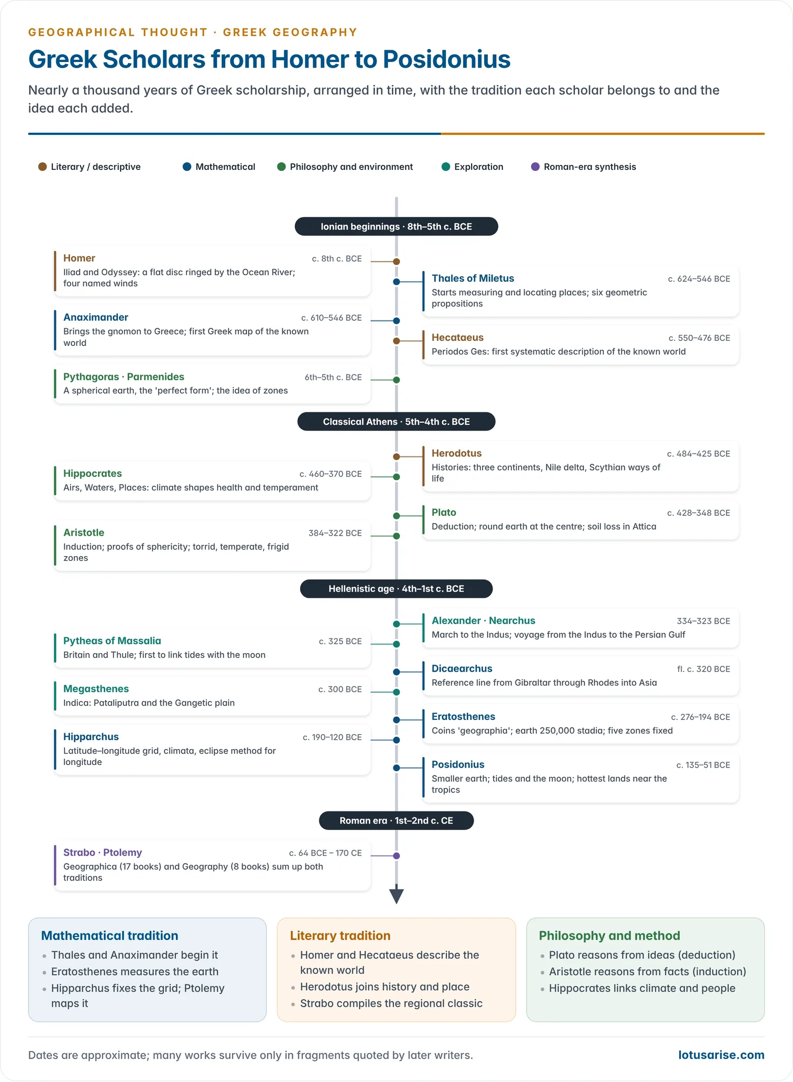
- Greek scholars laid the foundations of geography as an organised field of knowledge. Between Homer’s epics (c. 8th century BCE) and the age of Hipparchus and Posidonius (2nd–1st century BCE), they turned travellers’ tales into concepts, measurements and maps.
- They gave the subject its name, proved the earth a sphere, measured its size, divided it into climatic zones and drew the first maps on a frame of parallels and meridians.
- Their work also set up a framework of method, deduction and induction, description and explanation, that guided Western scholarship for many centuries.
- Some of these ideas held back later thinking. Modern geography could emerge only after the authority of Plato and Aristotle had been questioned.
- Two traditions grew from Greek scholarship and still run through the subject: the mathematical (location, shape and size of the earth) and the literary or descriptive (lands and peoples).
Foundations of Greek Geography

Borrowed Knowledge
- Greek learning built on the observations, measurements and generalisations of older civilisations:
- Egypt: land survey for taxation after the Nile floods, practical geometry, and writing on papyrus.
- Mesopotamia (Sumerians, Babylonians, Assyrians): the sexagesimal system (base 60), the division of the zodiac and circle into 360 parts, the gnomon, and long records of the movements of celestial bodies under clear skies.
- Phoenicians: seafaring and trade across the Mediterranean from ports such as Tyre and Sidon, colonies such as Carthage and Gadeira (Cádiz), and the first phonetic alphabet, to which the Greeks added vowels.
- Unlike the Phoenicians, who guarded their trade knowledge closely, the Greeks recorded and debated what they learned.
Why Greece Became the Centre
- Physical setting: a land of mountains, torrential rivers, limestone streams that vanish underground, earthquakes, hot springs and a deeply indented coastline.
- These features raised questions that pushed the Greeks towards early geomorphology, climatology and oceanography.
- Miletus in Ionia, near the mouth of the Meander (Menderes) river, was a busy port. Between the 8th and 6th centuries BCE, sailors and merchants brought it news of the Black Sea, Egypt and the East, along with Egyptian geometry and Babylonian astronomy.
- A group of thinkers there tried to arrange this mass of information into reasoned explanations. This Ionian school began Greek geography.
- Colonisation around the Mediterranean and the Black Sea (Euxine) widened the known world.
- Alexandria, founded by Alexander the Great in 331 BCE, became the centre of Hellenistic science. Its Library and Museum let scholars such as Eratosthenes compare itineraries, observations and older texts.
- Alexander’s campaigns (334–323 BCE) carried Greek observers to Persia, Central Asia and the Punjab.
- His staff included bematists (pacers who measured marching distances) and observers of star altitudes, who brought back a flood of new facts on terrain, peoples, plants and animals.
Two Traditions
- Mathematical tradition: fixing the location, shape and size of the earth and plotting places on a grid.
- It runs from Thales and Anaximander through Aristotle to Eratosthenes and Hipparchus, and later to Claudius Ptolemy.
- Literary (descriptive) tradition: describing places, peoples and ways of life in the known world.
- It runs from Homer and Hecataeus through Herodotus to Strabo.
- The contrast between the Milesians who sought general rules and Hecataeus who described particular places is often read, in hindsight, as the first sign of the later dualism between law-seeking (nomothetic) and descriptive (idiographic) geography.
| Feature | Mathematical tradition | Literary tradition |
|---|---|---|
| Central question | Where is it? How big is the earth? | What is the place like? Who lives there? |
| Method | Geometry, astronomy, measurement | Travel, observation, compilation |
| Key figures | Thales, Anaximander, Eratosthenes, Hipparchus | Homer, Hecataeus, Herodotus, Strabo |
| Outputs | Sphericity, circumference, zones, grids, projections | Regional and ethnographic descriptions |
| Modern descendant | Cartography, geodesy, spatial science | Regional and cultural geography |
Major Greek Scholars and Their Contributions
The Ionian Beginnings
Homer
- Homer’s epics, the Iliad and the Odyssey (c. 8th century BCE), are the oldest Greek sources of geographical information. Later Greek geographers, Strabo among them, honoured him as the founder of their subject.
- The Odyssey follows the wanderings of Odysseus across the Mediterranean world. Its hints of lands of long daylight and long darkness suggest that reports of the far north had reached Greece.
- World view: the earth is a flat, circular disc surrounded by the Ocean River (Oceanus). The sun rises from and sets into this stream, and the sky is a solid vault.
- Four winds: Boreas (north, cold and clear), Eurus (east, warm and gentle), Notus (south, wet and stormy) and Zephyrus (west, mild but at times gale-force).
- The Greeks later recognised eight wind directions. The octagonal Tower of the Winds in Athens shows each wind with the weather it brings.
Thales of Miletus
- Thales of Miletus (c. 624–c. 546 BCE), merchant, traveller and philosopher, was the first Greek to give focused attention to measuring and locating things on the earth’s surface. He is regarded as a founder of the mathematical tradition.
- He learned practical geometry in Egypt. His true contribution was to move from solving individual measurement problems to general propositions about them.
- Six geometric propositions are credited to him:
- A circle is bisected by its diameter.
- The base angles of an isosceles triangle are equal.
- When two parallel lines are cut by a transversal, the opposite (alternate) angles are equal. Eratosthenes later used this to measure the earth.
- The angle in a semicircle is a right angle.
- The sides of similar triangles are proportional.
- Two triangles are congruent if two angles and the included side are equal.
- Cosmology: water is the primary substance of all matter, and the earth is a disc floating on water. He is said to have predicted the solar eclipse of 585 BCE.
- Method: he offered explanations that could be checked by fresh observation and measurement, a sharp break from mythical accounts.
Anaximander
- Anaximander (c. 610–c. 546 BCE), a younger contemporary of Thales in Miletus, introduced the gnomon to the Greek world.
- The gnomon is a vertical rod over a flat surface. The shortest shadow marks local noon and gives a true north–south line (meridian). Seasonal changes in the noon shadow fix the solstices and equinoxes.
- He is credited with the first Greek map of the known world, drawn with Greece at the centre and the land surrounded by Ocean. It probably drew on older Mesopotamian pictorial maps.
- He pictured the earth as a short cylinder hanging free at the centre of the universe, not resting on anything. He traced thunder and lightning to clashing clouds rather than to the gods.
- He named the boundless first substance the apeiron, a concept reached by reasoning rather than by the senses, unlike Thales’ water.
- Thales and Anaximander together are counted as the founders of mathematical geography.
Hecataeus
- Hecataeus of Miletus (c. 550–c. 476 BCE), statesman, traveller and one of the first Greek prose writers, began the literary tradition of systematic regional description.
- His Periodos Ges (“Circuit of the Earth”, c. 500 BCE) is the first known systematic description of the known world. It survives only in fragments quoted by later writers.
- It was in two books: one on Europe, the other on Asia and Libya (Africa). It follows the coasts of the Mediterranean and Black Sea in the manner of a periplus (a coastal survey).
- It drew on his own travels, including a journey up the Nile to Thebes, and on the reports of merchants who reached Miletus.
- He improved Anaximander’s map. The world remained a flat disc ringed by Ocean, split into a northern Europe and a southern Asia–Libya along the line of the Hellespont, the Black Sea, the Caucasus and the Caspian.
- He treated the Caspian as a gulf of the outer Ocean.
- He knew of the Indus and of the Gandarii (Gandhara) of the north-west of the subcontinent, though only at second hand.
Herodotus
- Herodotus (c. 484–c. 425 BCE) of Halicarnassus, the “Father of History“, is also counted among the founders of geography and is often called the father of ethnography.
- His Histories, an inquiry into the wars between the Greeks and Persians, carries long geographical and ethnographic digressions drawn from his own travels.
- History and geography joined: he held that all history must be treated geographically and all geography historically. Geography is the stage on which events take on meaning.
- This is the root of historical geography. Halford Mackinder’s reading of history as a contest between land and sea powers reflects the same tradition.
- Travels: Egypt (up to Elephantine at the First Cataract), Phoenicia, Babylon, the Black Sea coasts and the steppes of Scythia, Cyrene and southern Italy.
- Physical geography:
- He explained the Nile delta as land built from silt carried down from Ethiopia, reconstructed the old shoreline and showed that former ports now lay inland. He also described Egypt as the “gift of the river”.
- He noted delta-building at the mouth of the Meander, described the regular Nile floods and tried to explain them, and related winds to temperature.
- World picture:
- He divided the land into three continents: Europe, Asia and Libya.
- He was the first to treat the Caspian as an inland sea, ahead of most later Greek geographers.
- He drew a crude meridian from the Nile through Cilicia and Sinope to the mouth of the Danube, and assumed a symmetrical world in which the Nile mirrored the Danube.
- He accepted Homer’s flat earth and took no interest in measuring it.
- Human geography:
- He described the Persian Empire’s 20 satrapies and the Royal Road from Sardis to Susa with its staging posts.
- He described the Scythian tribes by their modes of life (farmers in the Dnieper valley, nomads to the east) and the “silent trade” of the Carthaginians on the African coast.
- India, to him, was the land east of the Indus, with cotton “wool growing on trees” and a desert beyond.
- He reported Scylax of Caryanda’s voyage down the Indus to the Red Sea for the Persian king Darius I (c. 515 BCE) and the Phoenician circumnavigation of Africa under Pharaoh Necho.
The Philosophers: A Spherical Earth
Pythagoras, Parmenides and Eudoxus
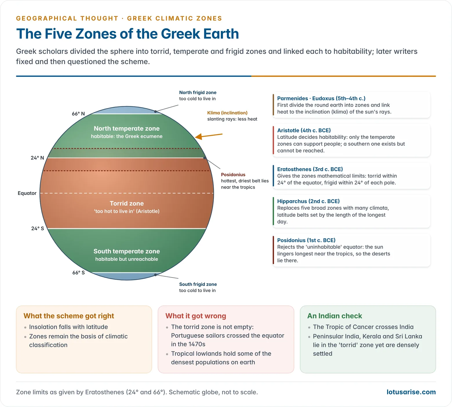
- Pythagoras (c. 570–c. 495 BCE) and his followers held the earth to be a sphere, on the reasoning that the sphere is the most perfect form. Parmenides applied this to a round earth divided into zones.
- Eudoxus of Cnidus (c. 408–c. 355 BCE), a contemporary of Plato, linked climate to the inclination (klima) of the sun’s rays on a curved surface. This gave the later word climate.
Plato
- Plato (c. 428–348 BCE) was the great exponent of deductive reasoning, moving from the general to the particular. Observable things are only imperfect copies of perfect ideas.
- His Phaedo contains the earliest surviving statement of a spherical earth at the centre of the universe, with celestial bodies moving round it in circles. He gave no proof; the sphere was simply the perfect form.
- On Attica, he wrote that the once-forested, fertile land had become “like the skeleton of a sick man”, with the soft soil washed away.
- He read this as decline from an ideal state. It is in fact an early account of deforestation and soil erosion, with man as an agent changing the face of the earth.
Aristotle
- Aristotle (384–322 BCE), Plato’s pupil for twenty years and tutor to Alexander, founded the Lyceum (335 BCE). He is the pioneer of inductive reasoning, moving from observed particulars to general laws.
- He held that the senses tell us that fire is hot but not why. Explanation needs reasoning.
- Four principles of explanation: the nature of a thing, the substance it is made of, the process that made it what it is, and the purpose it serves.
- This was the world’s first paradigm for research. The last principle makes him a teleologist: things develop towards an ideal state, an idea later echoed in Carl Ritter.
- Proofs of sphericity (On the Heavens, Meteorologica):
- The curved shadow of the earth on the moon during lunar eclipses.
- Different stars come into view as one travels north or south.
- Matter falling equally towards the centre must form a sphere.
- Zones of habitability: latitude decides whether people can live in a place.
- The torrid zone near the equator is too hot to live in, and the frigid zones near the poles too cold. Only the temperate zones are habitable.
- He guessed that a southern temperate zone existed but could not be reached across the heat.
- Physical geography: in Meteorologica he explained the slow gain of land on the sea through river deposits, and predicted that the shallow Sea of Azov would one day silt up.
- He also discussed earthquakes, winds and rain. His explanation of tides by winds was wrong.
- Political geography (Politics): he discussed the ideal size of a state’s population and territory, the site of the capital, defensible boundaries and the effect of climate on the character of peoples, placing the Greeks in a favoured middle position.
- Limitation: his reasoning seemed so complete that it was accepted without question for centuries. Modern science advanced only once his authority was set aside.
Hippocrates and the Environment
- Hippocrates (c. 460–c. 370 BCE), in On Airs, Waters, Places, explained differences in physique, health and temperament among peoples by climate, water and site.
- It is the first work of medical geography and an early statement of environmental determinism, contrasting the people of temperate Greece with those of Asia and of the cold north.
Explorers and the Widening Ecumene
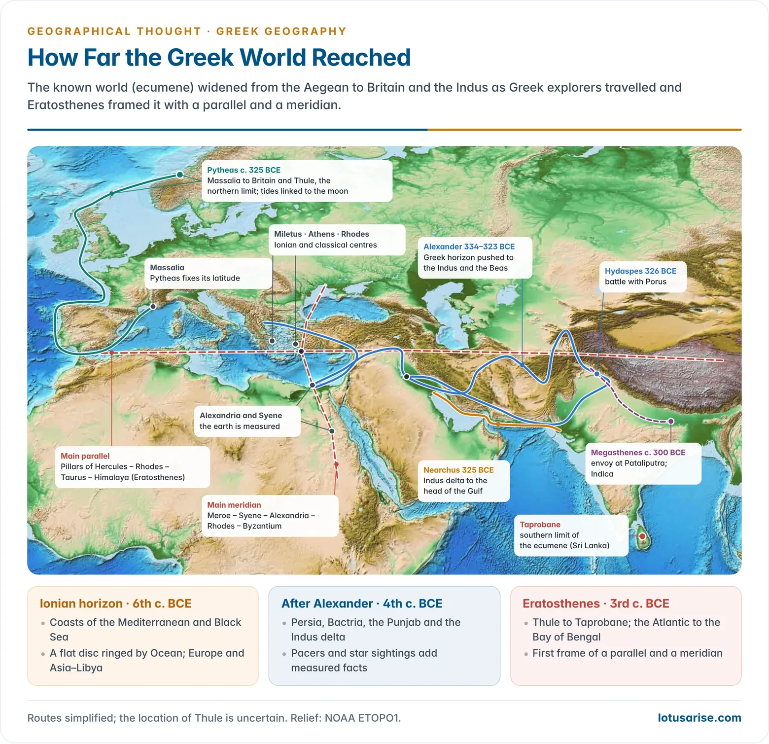
- Pytheas of Massalia (Marseille) sailed to Britain and the North Sea around 325 BCE.
- He reported Thule, six days north of Britain, where the midsummer sun barely set, and a frozen sea beyond.
- He measured the latitude of Massalia with a gnomon to within a few minutes of arc.
- He was the first to link tides with the phases of the moon.
- His contemporaries dismissed him, but most of his reports are now accepted.
- Alexander’s expedition pushed Greek knowledge to the Indus. He defeated Porus on the Hydaspes (Jhelum) in 326 BCE, and his troops refused to go beyond the Beas (Hyphasis).
- Nearchus sailed from the Indus delta to the head of the Persian Gulf (325 BCE), recording the coast, tides and monsoon conditions of the Arabian Sea.
- Megasthenes, envoy of Seleucus I to Chandragupta Maurya’s court at Pataliputra (c. 300 BCE), wrote the Indica.
- It is the first detailed Greek account of the Gangetic plain, its rivers, cities and society. It survives in quotations by later authors.
The Hellenistic Scientists
Dicaearchus
- Dicaearchus of Messana (fl. c. 320 BCE), a pupil of Aristotle, drew a dividing line across the known world from the Strait of Gibraltar through Rhodes to the mountains of Asia. It was the first reference line resembling a parallel of latitude.
- He also estimated mountain heights by measurement, to show that relief did not spoil the earth’s sphericity.
Eratosthenes
- Eratosthenes of Cyrene (c. 276–c. 194 BCE), chief librarian at Alexandria for some forty years, is widely called the “Father of Geography“.
- He coined the word geographia (ge, earth, and graphein, to describe) and wrote the first formal treatise on the subject, the Geographika in three books. It is lost and known through Strabo.
- Measuring the earth:
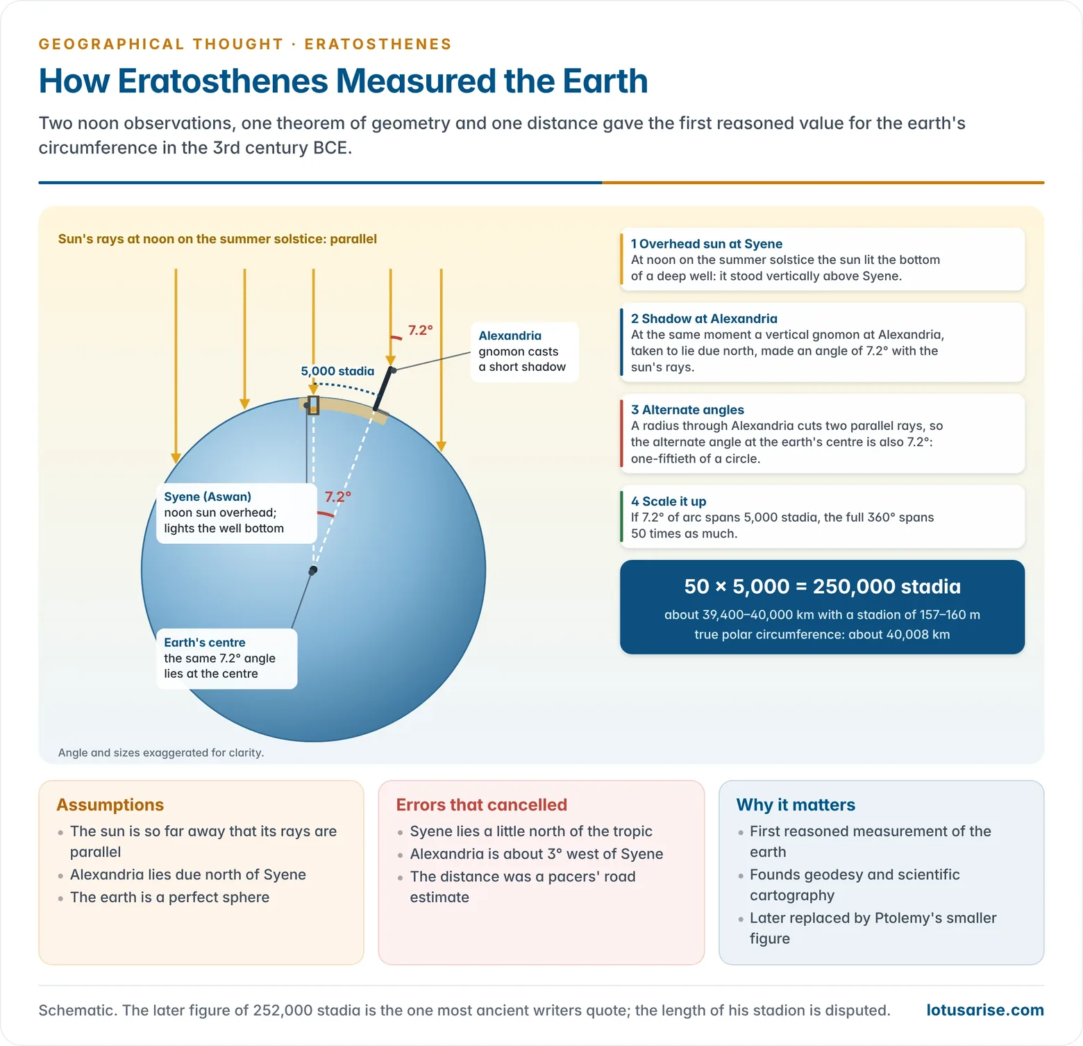
- At Syene (Aswan) at the summer solstice, the noon sun lit the bottom of a deep well, so it stood directly overhead.
- At Alexandria, taken to lie due north, a vertical gnomon cast a shadow at the same moment. The sun’s rays made an angle of about 7.2°, or one-fiftieth of a circle, with the vertical.
- By the geometry of alternate angles (a line cutting two parallel lines), the same angle lies at the earth’s centre between the two places.
- The distance between them was about 5,000 stadia, so the circumference was 50 × 5,000 = 250,000 stadia (later quoted as 252,000).
- With a stadion of about 157–160 m, this is within about 1–2% of the true polar circumference of about 40,000 km. The exact length of his stadion is disputed.
- Errors cancelled out: Syene lies slightly north of the tropic, Alexandria is about 3° west of it, and the distance was a road estimate. He also assumed a perfect sphere.
- Other contributions:
- He measured the tilt of the earth’s axis (obliquity of the ecliptic) at about 23°51′.
- He drew a world map on a frame of parallels and meridians, irregularly spaced. A main parallel ran through the Pillars of Hercules and Rhodes to India, and a main meridian through Meroe, Syene, Alexandria, Rhodes and Byzantium.
- His ecumene ran from Thule to Taprobane (Sri Lanka) and from the Atlantic to the Bay of Bengal. He judged it much longer from west to east than from north to south.
- He gave the five zones mathematical limits: the torrid zone within 24° of the equator, the frigid zones within 24° of each pole, and two temperate zones in between.
- He pictured India as a rhomboid bounded by the Himalaya (Imaus) in the north, with the Ganges flowing east to the outer Ocean. The outline was wrong but rested on the reports of Alexander’s surveyors.
Crates of Mallus
- Crates of Mallus (2nd century BCE), at Pergamon, built the earliest recorded terrestrial globe.
- It showed the known ecumene and three other hypothetical landmasses, separated by ocean belts. This was a symmetrical guess that fed later ideas of a southern continent.
Hipparchus
- Hipparchus (c. 190–c. 120 BCE), working mainly on Rhodes, was the greatest astronomer of antiquity and a founder of trigonometry.
- He discovered the precession of the equinoxes and compiled a catalogue of about 850 stars.
- Geography: in a three-book critique, Against the Geography of Eratosthenes, he argued that maps must rest on astronomical fixes of latitude and longitude, not on travellers’ distances.
- He made the 360° circle standard in Greek work, drawing on Babylonian practice. He treated the equator and meridians as great circles and showed that parallels shrink towards the poles.
- The earth turns 15° of longitude per hour. He proposed finding longitude by timing the same lunar eclipse at different places, a sound method that the clocks of his age could not apply.
- He drew up a table of climata (latitude belts) listing the latitudes of many places by the length of their longest day.
- Later writers credit him with an early astrolabe for measuring star altitudes and with the stereographic and orthographic projections, each of which shows only a hemisphere. These attributions are uncertain.
- Recent scholarship: in 2022, multispectral imaging of a medieval manuscript from Saint Catherine’s Monastery in Sinai, the Codex Climaci Rescriptus, revealed a Greek passage with star coordinates that several scholars attribute to Hipparchus’ lost catalogue.
- The positions are accurate to about 1°, but the attribution is still debated.
Posidonius
- Posidonius (c. 135–c. 51 BCE), a Stoic philosopher from Apamea in Syria who taught on Rhodes, was the leading polymath of his age.
- Earth’s size: he used the altitude of the star Canopus at Rhodes and Alexandria and reached 240,000 stadia.
- A version of his result based on a shorter distance, 180,000 stadia, about a quarter too small, was the one Ptolemy adopted. Through Ptolemy it shrank the earth in European minds for some 1,500 years and encouraged Christopher Columbus to think Asia lay a short sail west.
- Habitability: he rejected Aristotle’s uninhabitable equator. The hottest and driest lands lie near the tropics, where the sun lingers overhead longest, and the equatorial belt is milder.
- This correct idea was largely ignored.
- Oceans: in On the Ocean he linked tides to the moon, recorded the large Atlantic tides at Gades (Cádiz), and noted the highest tides at new and full moon (spring tides) and the lowest at the quarters (neap tides).
Strabo and Ptolemy: The Bridge to Rome
- Strabo (c. 64 BCE–c. 24 CE), a Greek writing under the Roman Empire, summed up the literary tradition in the 17-book Geographica. It is the fullest descriptive geography of the ancient world and the classic model of chorological (regional) writing.
- Ptolemy (c. 100–c. 170 CE) of Alexandria summed up the mathematical tradition in the Almagest and the eight-book Geography. These were coordinate tables of some 8,000 places on a graticule, which the Arabs preserved and Renaissance Europe revived.
Contributions by Branch
| Branch | Greek contribution | Main scholars |
|---|---|---|
| Mathematical geography | Spherical earth, circumference, tilt of the axis, latitude and longitude | Pythagoras, Aristotle, Eratosthenes, Hipparchus |
| Cartography | First world maps, reference parallel and meridian, globe, projections | Anaximander, Hecataeus, Dicaearchus, Eratosthenes, Crates, Hipparchus |
| Climatology | Wind system, five zones, climata, sun angle and heat | Homer, Eudoxus, Aristotle, Eratosthenes, Posidonius |
| Geomorphology | Deltas, alluvial land gain, erosion, earthquakes | Herodotus, Aristotle, Plato |
| Oceanography | Tides and the moon, spring and neap tides | Pytheas, Posidonius |
| Human and regional | Ethnography, ways of life, regional description, India | Hecataeus, Herodotus, Megasthenes |
| Man and environment | Climate and character, human impact on land | Hippocrates, Aristotle, Plato |
| Method | Deduction vs induction, teleology, description vs explanation | Plato, Aristotle |
- Mathematical geography reached its height with Eratosthenes. Sphericity was argued and tested, the earth’s size computed, latitudes fixed and maps placed on a grid.
- Physical geography advanced more slowly, through speculation on weather, tides, volcanoes, the Nile floods and the slow work of rivers.
- Human geography began as ethnography and regional description. The link drawn between climate and human character passed down through Rome and the Arabs to the determinists of the 19th century.
Evaluation
- Strengths:
- The Greeks turned geography from myth to reasoned explanation and gave it a name, a method and a measured earth.
- Their two traditions, measurement and description, still define the subject’s systematic and regional faces.
- Limitations:
- Theory ran ahead of observation. The sphere was accepted because it was “perfect”, the world was assumed to be symmetrical, and Aristotle’s uninhabitable torrid zone survived until Portuguese voyages disproved it in the 15th century.
- Longitude could not be fixed accurately. Distances came from travellers’ estimates, and the smaller circumference chosen by Ptolemy carried a large error into later maps.
- Most of the original works are lost and survive only through Strabo, Pliny, Ptolemy and later compilers.
- The received story is Greek-centred. Parallel traditions in India, Mesopotamia and China developed their own astronomy and earth description.
- Legacy:
- Through the Arab translators and the Renaissance, Greek geography became the starting point of the Age of Exploration and of modern geographical thought.
- Herodotus’ ethnography, Hippocrates’ environmental reasoning and Eratosthenes’ geodesy each have modern descendants.
Previous Year Questions
- No direct PYQ has been asked on this sub-topic yet.


Wow! Such a commendable and amazing work.