

- India’s peaks fall into two broad settings: the young fold ranges of the north, with heights above 8,000 m, and the old blocks of the Peninsula, where Anai Mudi (2,695 m) tops everything outside the Himalaya.
- K2 (8,611 m) is the highest peak in India. It lies in Pakistan-occupied Kashmir, which is part of India.
- Kanchenjunga (8,586 m) is the highest peak on ground India holds, and Nanda Devi (7,816 m) is the highest lying wholly within India.
- Heights vary by a few metres between surveys, so the older figure stands in brackets wherever it differs.
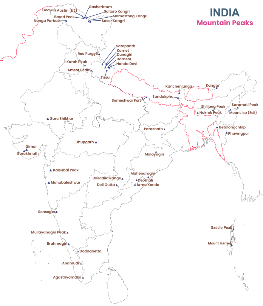
- Mount Harriet on this map has been Mount Manipur since 17 October 2021.
Highest Peaks of the North
Highest Mountain Peaks in India
| Mountain peak | Height (m) | Range and place | World rank | Other names and notes |
|---|---|---|---|---|
| K2 (Godwin Austen) | 8,611 | Karakoram; Pakistan-occupied Kashmir | 2nd | Highest in the Karakoram and in India |
| Kanchenjunga | 8,586 (8,598) | Himalaya; Sikkim–Nepal boundary | 3rd | Kangchenjunga, Khangchendzonga; “five treasures of snow” |
| Nanda Devi | 7,816 (7,817) | Garhwal Himalaya; Chamoli, Uttarakhand | 23rd | Highest wholly within India |
| Kamet | 7,756 | Garhwal Himalaya; Chamoli, Uttarakhand | 29th | Near the Tibetan Plateau |
| Saltoro Kangri | 7,742 | Saltoro Range, Karakoram; Ladakh | 31st | Near Siachen |
| Saser Kangri I | 7,672 | Saser Muztagh, Karakoram; Ladakh | 35th | Easternmost Karakoram subrange |
| Mamostong Kangri | 7,516 | Rimo Muztagh, Karakoram; Ladakh | 47th to 48th | Mamostang Kangri; near Siachen |
| Rimo I | 7,385 | Rimo Muztagh, Great Karakoram; Ladakh | 71st | Highest of the Rimo group |
| Hardeol | 7,151 | Kumaon Himalaya; Chamoli–Pithoragarh | “Temple of God” | |
| Chaukhamba I | 7,138 | Gangotri Group, Garhwal Himalaya; Uttarkashi–Chamoli | Older lists give Badrinath at this height | |
| Trisul I | 7,120 (7,140) | Kumaon Himalaya; Chamoli | Named after Lord Shiva’s trident |
- K2’s position: it stands in Baltistan, in the Pakistan-occupied part of Ladakh, where the Karakoram crest meets Xinjiang.
- Its northern side faces the Shaksgam tract, which Pakistan illegally ceded to China under a 1963 agreement that India has never recognised.
- Nanda Devi ranks 23rd in the world. The nearby Nanda Devi National Park holds some of the best high-altitude flora and fauna in the country.
- Saltoro Kangri ranks 31st among independent peaks, and Saser Kangri I 35th, in the listing used above. Rimo I is 71st.
- Hardeol long had no name of its own and was known as the south peak of Tirsuli. People of the Johar valley worship it, and it was first climbed in 1978.
- Chaukhamba I is the highest of the four summits of a massif at the head of the Gangotri Glacier, first climbed in 1952.
- Trisul I is one of a group of three peaks, which together suggest the trident that gives them their name.
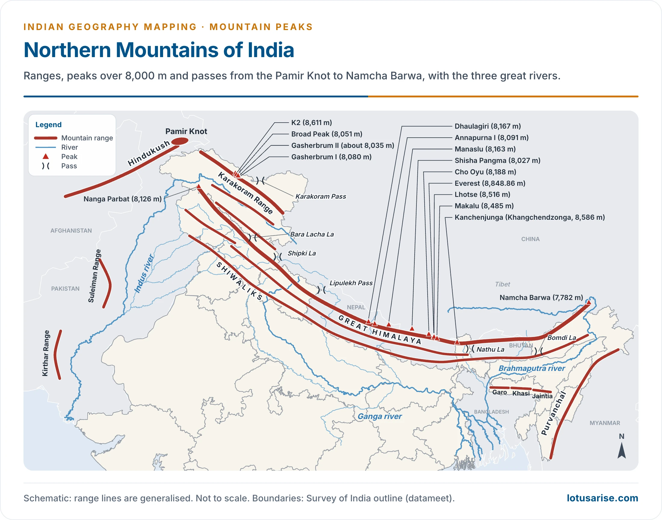
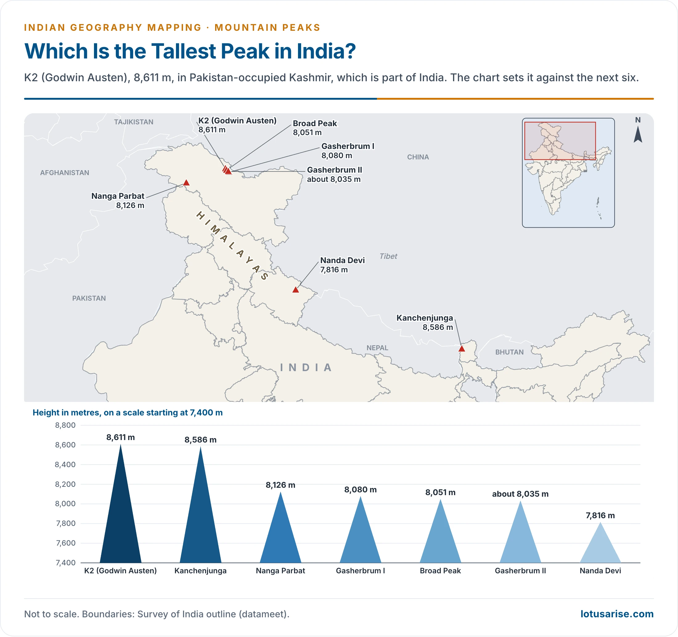
Peaks of the Great Himalaya and Karakoram
- The Great Himalaya is the loftiest and most continuous of the ranges, ending at Nanga Parbat in the north-west and Namcha Barwa in the north-east.
- Mount Everest (8,848.86 m) lies on the Nepal–Tibet boundary, outside India, but gives the scale.
- Nepal and China announced this figure jointly on 8 December 2020. The Survey of India’s 1954 value was 8,848 m, an American GPS survey gave 8,850 m, and China’s 2005 survey gave 8,844.43 m.
- George Everest was Surveyor General of India, and the peak, earlier called Peak XV, was named after him in 1865. Nepal calls it Sagarmatha and Tibet Chomolungma (Qomolangma).
- Over 7,000 m: more than forty named peaks of the Great Himalaya pass this height.
- The table sets out the wider list by section, from west to east.
| Section | Area | Peaks with height (m) |
|---|---|---|
| Karakoram | Pakistan-occupied Kashmir and Ladakh | K2 8,611; Gasherbrum I (Hidden Peak) 8,080 (8,068); Broad Peak 8,051 (8,047); Gasherbrum II 8,035; Masherbrum 7,821; Disteghil Sar 7,884; Rakaposhi 7,788; Kanjut Sar 7,760; Haramosh 7,397 |
| Kashmir and Himachal | Jammu and Kashmir, Ladakh, Himachal Pradesh | Nanga Parbat 8,126; Nun 7,135; Reo Purgyil 6,816 (Leo Pargial 6,773) |
| Garhwal and Kumaon | Uttarakhand | Nanda Devi; Kamet; Abi Gamin 7,355; Mana 7,272; Hardeol; Chaukhamba I; Trisul I; Satopanth 7,075; Dunagiri 7,066; Kedarnath 6,974 (6,968); Shivling 6,547 (6,638); Bandarpunch 6,318 (6,320) |
| Nepal Himalaya | Nepal and its boundaries | Everest; Kanchenjunga; Lhotse 8,516 (8,501); Makalu 8,485 (8,481); Cho Oyu 8,188 (8,153); Dhaulagiri 8,167 (8,172); Manaslu 8,163 (8,156); Annapurna I 8,091 (8,078); Shisha Pangma or Gosainthan 8,027 (8,013) |
| Beyond the crest | Tibet | Gurla Mandhata 7,694 (7,728); Kailas 6,714 |
| Eastern Himalaya | Arunachal Pradesh, Bhutan and Tibet | Namcha Barwa 7,782 (7,756); Kula Kangri 7,538 (7,554); Chomo Lhari 7,327; Nozin Kang Sa 7,252; Gyala Peri 7,151; Kangto 7,060 (7,090) |
| Purvanchal | Nagaland, Mizoram, Manipur | Saramati 3,826; Mount Iso 2,994; Phawngpui 2,157 |
Northern Peaks in Detail
- Nanga Parbat (8,126 m):
- Ninth highest peak of the world, in Pakistan-occupied Kashmir, just near the Indus Gorge.
- It forms the western terminus of the Himalaya, at the western syntaxial bend, where the ranges turn sharply round the river.
- First climbed by the Austrian Hermann Buhl on 3 July 1953, alone for the final push and without bottled oxygen.
- Godwin Austen (K2):
- The world’s second highest peak, in the central Karakoram. The Godwin Austen Glacier drains its slopes and joins the Baltoro.
- It is known as the Savage Mountain for the difficulty of the ascent. Older accounts give it the second highest fatality rate among the highest peaks, after Annapurna.
- First winter ascent: ten Nepali climbers reached the summit on 16 January 2021. It had been the last of the 8,000 m peaks unclimbed in winter.
- Kanchenjunga:
- The third highest summit in the world, on the Sikkim–Nepal boundary, and Sikkim’s highest point.
- The Khangchendzonga National Park below it was inscribed as a World Heritage site in 2016.
- Kamet:
- Second highest peak of Uttarakhand, in Chamoli district, east of the Gangotri Glacier and close to the Tibet boundary.
- It stands near the Mana Pass and was first climbed on 21 June 1931.
- Nanda Devi:
- Highest peak of Uttarakhand, between the Milam Glacier and the Pindar Glacier. First climbed in 1936.
- It lies within the Nanda Devi National Park, a World Heritage site since 1988, extended in 2005 to take in the Valley of Flowers.
- It is the second highest peak of India if the peaks of Pakistan-occupied Kashmir are set aside.
- Satopanth (7,075 m):
- In the Gangotri region of the Garhwal Himalaya in Uttarakhand, inside the Gangotri National Park.
- The Alaknanda begins at the foot of the Satopanth and Bhagirath Kharak glaciers below this peak.
- Dunagiri (7,066 m):
- In Chamoli district of Uttarakhand, at the north-west corner of the ring of peaks that surrounds Nanda Devi.
- Abi Gamin (7,355 m):
- In Chamoli district of Uttarakhand, about 2 km north-north-east of Kamet.
- A high saddle, Meade’s Col (about 7,100 m), separates it from Kamet. The well-known Mana and Niti passes lie in this tract.
- Saltoro Kangri (7,742 m):
- It stands on the Saltoro Ridge, along the Actual Ground Position Line that runs north of point NJ9842, where the Line of Control ends.
- Operation Meghdoot (13 April 1984) brought the Siachen heights under India’s military control.
- Kangto (7,060 m):
- It lies on the Arunachal Pradesh–Tibet boundary in the Eastern Himalaya, and is also known as Kanggardo Rize.
- It is the source of the Pachuk, a tributary of the Kameng.
- Namcha Barwa (7,782 m):
- The eastern anchor of the Himalaya, in Tibet near the Indian boundary, where the Tsangpo–Brahmaputra bends round it.
- The easternmost mountain in the world over 7,600 m.
- Saramati (3,826 m):
- The highest peak of the Naga Hills, in the Purvanchal, near the border with Myanmar.
- It is snow-covered during the winter and is a popular trekking destination.
- Blue Mountain (Phawngpui, 2,157 m; 2,156 m in older accounts):
- The highest peak of Mizoram, in Lawngtlai district near the Myanmar border, within Phawngpui National Park.
- Its name means great meadow. Trees and flowers of many colours and blue-hazed hills give it a fairytale look.
- The area is encircled by matted bamboo groves and other vegetation.
- Nokrek (1,412 m):
- The highest peak of the Garo Hills in Meghalaya, at the centre of a biosphere reserve that joined UNESCO’s world network in May 2009.
State-wise Peaks and the Peninsula
State-wise Highest Mountain Peaks in India
| Peak | Range or region | State or Union Territory | Height (m) |
|---|---|---|---|
| Saddle Peak | North Andaman | Andaman and Nicobar Islands | 732 (737) |
| Arma Konda | Eastern Ghats | Andhra Pradesh | 1,680 |
| Kangto | Eastern Himalaya | Arunachal Pradesh | 7,060 (7,090) |
| Unnamed peak | Dima Hasao hills | Assam | 1,960 |
| Someshwar Fort | West Champaran district, Shiwaliks | Bihar | 880 |
| Bailadila Range (Nandiraj) | Dantewada district | Chhattisgarh | 1,276 |
| Sonsogor | Western Ghats | Goa | 1,166 (1,026) |
| Girnar | Junagadh district | Gujarat | 1,069 (1,117; 1,145) |
| Karoh Peak | Morni Hills, Shiwaliks | Haryana | 1,467 |
| Reo Purgyil | Western Himalaya | Himachal Pradesh | 6,816 |
| Parasnath | Parasnath Hills | Jharkhand | 1,366 (1,370) |
| Mullayanagiri | Western Ghats | Karnataka | 1,930 (1,913) |
| Anai Mudi | Western Ghats | Keralam (Kerala) | 2,695 |
| K2; Saltoro Kangri on ground India holds | Karakoram | Ladakh | 8,611; 7,742 |
| Dhupgarh | Satpura | Madhya Pradesh | 1,350 (1,352) |
| Kalsubai | Western Ghats | Maharashtra | 1,646 |
| Mount Iso (Tempu, Esii) | Senapati district | Manipur and Nagaland border | 2,994 |
| Shillong Peak | Khasi Hills | Meghalaya | 1,965 (1,961) |
| Phawngpui | Lawngtlai district | Mizoram | 2,157 |
| Mount Saramati | Naga Hills | Nagaland | 3,826 |
| Deomali | Eastern Ghats | Odisha | 1,672 |
| Unnamed peak | Naina Devi range, Shiwaliks | Punjab | 1,000 |
| Guru Shikhar | Aravalli Range | Rajasthan | 1,722 |
| Kanchenjunga | Eastern Himalaya | Sikkim | 8,586 |
| Doddabetta | Nilgiri Hills | Tamil Nadu | 2,637 |
| Doli Gutta | Deccan Plateau | Telangana and Chhattisgarh border | 965 |
| Betalongchhip | Jampui Hills | Tripura | 930 |
| Amsot Peak | Shiwalik Hills, Saharanpur | Uttar Pradesh | 945 (957) |
| Nanda Devi | Garhwal Himalaya | Uttarakhand | 7,816 |
| Sandakphu | Eastern Himalaya | West Bengal | 3,636 |
- Jindhagada Peak (1,690 m) in the Araku Valley is usually taken as the highest point of the Eastern Ghats, above Arma Konda.
Peninsular and Island Peaks in Detail
- Guru Shikhar (Gurushikhar):
- Highest peak of the Aravalli and of Rajasthan, in Sirohi district, about 15 km from Mount Abu.
- Home to a temple of Dattatreya, regarded as an incarnation of Lord Vishnu.
- The Mount Abu Observatory stands beside the temple.
- Dhupgarh:
- Highest peak of the Satpura Range, in the Mahadeo Hills near Pachmarhi, and the highest point of Madhya Pradesh.
- The summit is formed of the coarse white Pachmarhi sandstone of Gondwana age. Basalt, slate, schist and granite occur elsewhere in the wider Satpura.
- An important tourist spot, known for its sunset views.
- Malayagiri (Malaygiri, 1,187 m):
- Located in the south-eastern part of the Garhjat Hills, and their highest peak, near Pallahara in Angul district of Odisha.
- It stands between the Brahmani and Baitarani rivers, in a tract rich in metallic minerals.
- Mahendragiri (1,501 m):
- A peak of the Eastern Ghats near Brahmapur (Berhampur), in Gajapati district of Odisha on its Ganjam edge, close to the border with Andhra Pradesh.
- It is often quoted as Odisha’s highest point, though Deomali (1,672 m) in Koraput district stands higher.
- A second Mahendragiri, in Tirunelveli district of Tamil Nadu, houses the ISRO Propulsion Complex.
- Arma Konda (1,680 m):
- A peak of the northern Eastern Ghats in Andhra Pradesh. Gali Konda (1,643 m) and Sinkram Gutta (1,620 m) stand nearby.
- Doddabetta:
- Highest peak of the Nilgiri Hills, in the Nilgiris district of Tamil Nadu, about 9 km from Udagamandalam (Ooty) on the Kotagiri road.
- A popular tourist attraction with road access up to the summit.
- The observatory at the top has two telescopes, open since 1983.
- Shola forests cover the hollows on its slopes.
- Anai Mudi (Anamudi):
- In Keralam (Kerala), the highest peak of the Western Ghats and of South India, and the highest in India outside the Himalaya.
- The name literally means “elephant forehead”.
- It stands at the junction of the Palani, Cardamom and Anaimalai hills, in the southern part of the Eravikulam National Park.
- Kalsubai:
- Highest peak of the Sahyadri in Maharashtra, near Igatpuri, on the edge of Ahilyanagar (Ahmednagar) and Nashik districts.
- Various trekking routes and animal tracks lead to the summit, where a small temple of Kalsubai stands.
- Mahabaleshwar:
- A major hill station of the Sahyadri, in Satara district of Maharashtra, at 1,438 m.
- Its altitude gives it a cool climate, and the Krishna rises near it.
- Saddle Peak:
- Twin peaks with a distinct saddle between them, the highest point of the Andaman and Nicobar Islands, at 732 m (737 m in older accounts).
- It lies in North Andaman, and is part of the Saddle Peak National Park.
- Mount Manipur (Mount Harriet, 383 m) near Sri Vijaya Puram is a lower hill of the same islands.
- Parasnath:
- The highest peak of Jharkhand, in Giridih district, at the eastern end of the Hazaribagh plateau on the Chotanagpur. The Rajmahal Hills, on the plateau’s north-eastern edge, reach only 567 m.
- It holds an important Jain temple devoted to Parasnath.
- It rises from Archaean granites and gneisses, and the wider plateau holds deposits of iron and manganese.
- Agasthya Malai:
- On the border of Tamil Nadu and Keralam, at about 1,868 m.
- The Thamirabarani River rises on the eastern side of the hill, and the Neyyar and Karamana flow west.
- The western side falls in the Neyyar Wildlife Sanctuary. The surrounding region was declared the Agasthyamalai Biosphere Reserve, which joined UNESCO’s world network in March 2016.
- Girnar:
- An igneous plutonic complex in Junagadh district of Gujarat, intruded into the Deccan basalts. Its summit is known as Gorakhnath Peak, and it is a major Jain and Hindu pilgrimage hill. Datar Hill rises close by.
- Indrakiladri (Indrakeeladri):
- A hill at Vijayawada on the Krishna, in Andhra Pradesh, crowned by the temple of the goddess Kanaka Durga.
- Brahmagiri:
- A hill on the Karnataka–Keralam boundary in the Western Ghats, marked on the opening map.
Other Peninsular Peaks
| Range | Peaks with height (m) |
|---|---|
| Northern Sahyadri | Salher 1,567; Harishchandragarh 1,424 |
| Middle Sahyadri | Vavul Mala 2,339; Kudremukh 1,892; Pushpagiri 1,714 |
| Nilgiri | Makurti 2,554 |
| Satpura and Maikala | Astamba Dongar 1,325; Amarkantak 1,127 |
| Chotanagpur | Goru 1,142; Netarhat Pat 1,119 |
- Kudremukh in Karnataka gives its name to a national park and an old iron-ore mining tract.
Previous Year Questions
2025Map item: Datar Hill2020Map item: Gurushikhar2019Map item: Anamudi2017Map item: Doddabetta2016Map item: Kudremukh2015Map item: Namcha Barwa2015Map item: Nokrek2015Map item: Gorakhnath Peak2015Map item: Indrakiladri Peak2015Map item: Anamudi2014Map item: Guru Shikhar2014Map item: Mahendragiri




Best content on google i ever read
Sir itna content to Wikipedia m bhi nhi hoga
Yeah Bro.
———
Lotus Arise Par Sabhi topics ko bahut achche se write kiya gaya hai
No misprint and also , Deep knowledge… ❤️
Exam ma aiya tha nanga parbat also known as killers mountain,you have not mentioned
small correction in nanda devi(kumaon mountains)
Very nice content , nice image