

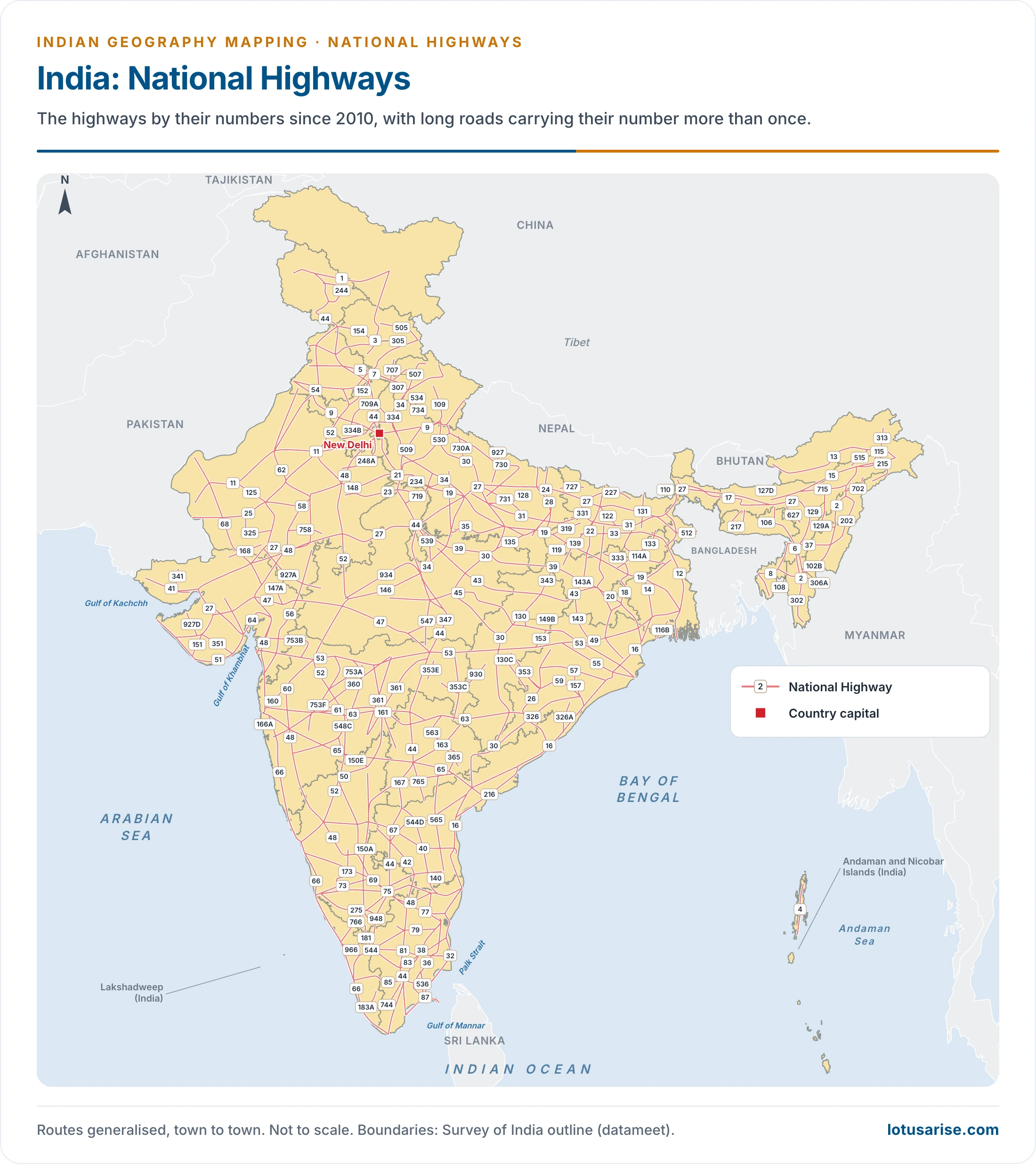
- National Highways are India’s trunk roads, owned by the Ministry of Road Transport and Highways (MoRTH). The ministry has counted 599 National Highways in its published list, and their numbering has been renewed over time.
- They carry inter-state traffic and the movement of defence personnel and material. They join State capitals, big cities, important ports and big railway junctions, and they link up with the border roads.
- Placing one on a map takes three things: the number rule, the present route, and the old number still printed on many maps.
The Network
Length, Share and Who Builds Them
- Construction and management rest with the National Highways Authority of India (NHAI), the National Highways and Infrastructure Development Corporation Limited (NHIDCL), the public works departments (PWDs) of State governments and the Border Roads Organisation.
- NHIDCL, incorporated on 18 July 2014, is a public sector company of the ministry, working in the north-east and on strategic and border-area roads.
- Length over time:
- 19,811 km in 1951, 79,116 km in 2013 and 91,287 km in 2014.
- A figure of 1,51,019 km (93,839 mi) was widely quoted for March 2021. The ministry’s annual report for 2020–21 gives 1,36,440 km.
- The count stood at 1,46,560 km in December 2025, and at about 1.46 lakh km in the ministry’s May 2026 reply in Parliament.
- Not all of the growth is new construction, because many State roads have been declared National Highways.
- Share and load: a share of 2.7% of the road network and about 40% of road traffic was long quoted for 2013.
- The category counts give a share of 4.95% in 1951, about 1.7% in 2013 and about 2.1% in 2019.
- The 2018–19 road statistics put the load nearer one-third.
- Width: a single lane is 3.75 m, and a multi-lane road 3.5 m per lane.
- In 2014 the network was 24% single lane, 52% double lane and 24% four lane or more.
- By December 2025, 43,512 km had four or more lanes, against 18,371 km in 2014. A Lok Sabha reply reported in May 2026 gave a higher count, 48,422 km.
- State lengths in 2014: Uttar Pradesh (5,874 km), Rajasthan (5,585 km), Madhya Pradesh (4,670 km), undivided Andhra Pradesh (4,472 km) and Tamil Nadu (4,462 km) led.
- New highways keep being declared. Those of August 2014 include NH-11 Narnaul–Rewari, NH-54 Dabwali–Hanumangarh–Goluwala, NH-248A Nuh–Gurugram (Gurgaon), NH-344B Sonipat–Jhajjar–Joharu and NH-703 Sirsa to the Haryana–Punjab border.
Longest, Shortest, Highest and First
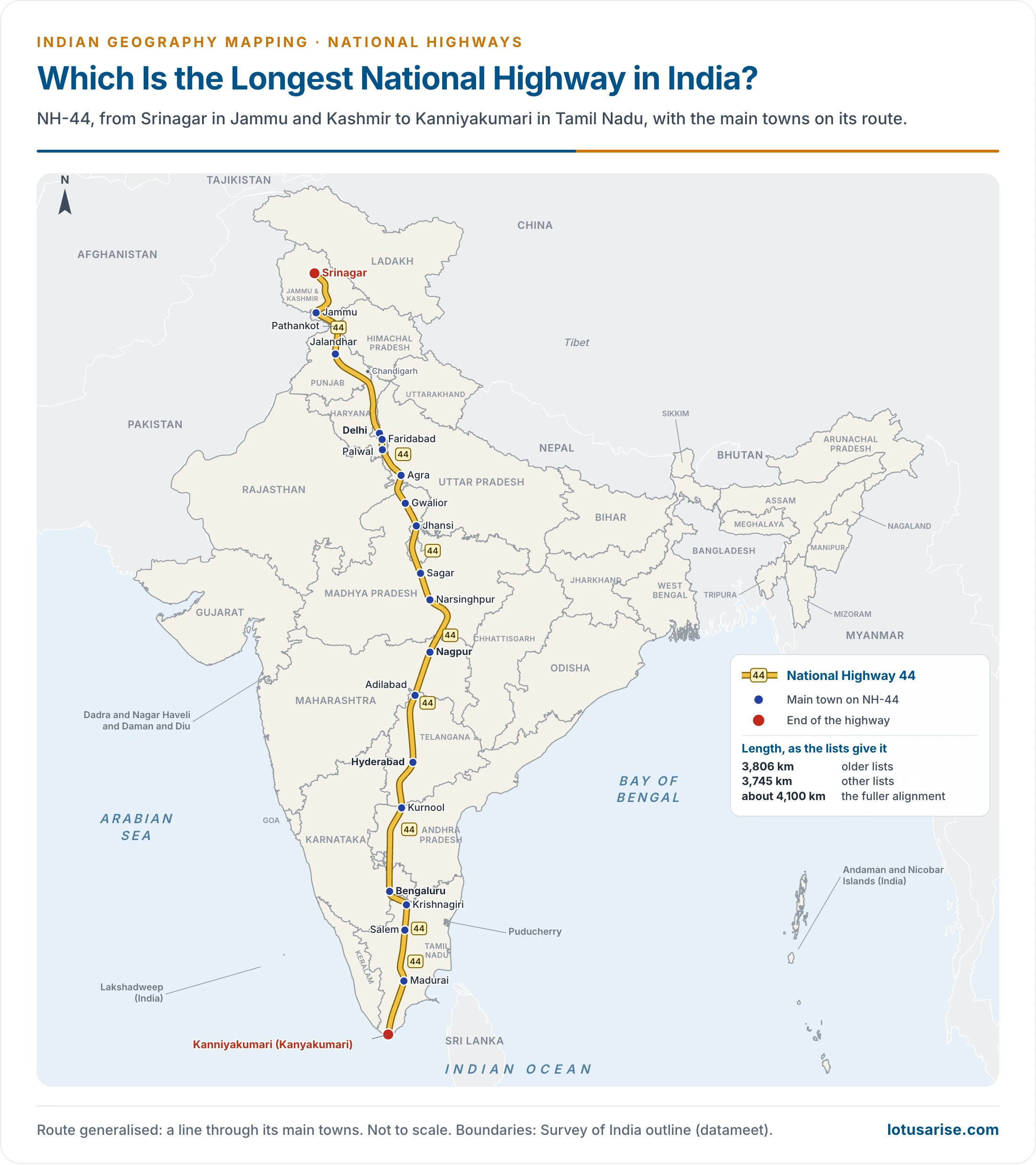
- Longest: NH-44, from Srinagar in Jammu and Kashmir to Kanniyakumari (Kanyakumari) in Tamil Nadu.
- Its length is listed as 3,806 km (2,365 mi) in older lists and as 3,745 km in others. The fuller alignment is given as about 4,100 km.
- It passes through Jammu and Kashmir, Himachal Pradesh, Punjab, Haryana, Delhi, Uttar Pradesh, Rajasthan, Madhya Pradesh, Maharashtra, Telangana, Andhra Pradesh, Karnataka and Tamil Nadu.
- Main towns on it are Jammu, Pathankot, Jalandhar, Delhi, Agra, Gwalior, Jhansi, Nagpur, Hyderabad, Kurnool, Bengaluru, Salem and Madurai.
- Under the old scheme, NH-7, at 2,369 km, held this place.
- Shortest: NH-766EE, 4.27 km (2.65 mi), from Hattikeri (Hettikeri) on NH-66 to Belekeri port in Karnataka.
- Under the old scheme the shortest was NH-47A, at about 5.9 km, into Willingdon Island at Kochi.
- High-altitude road: the Leh–Manali Highway, joining Leh in Ladakh to Manali in Himachal Pradesh, has long been called the world’s second highest motorable highway.
- The stretch now forms part of NH-3, which runs from Attari to Leh and takes the Atal Tunnel under Rohtang.
- Newer works rise above it: the road at Umling La in eastern Ladakh, at 19,024 ft, entered Guinness World Records as the highest motorable road (2021), and the Likaru–Mig La–Fukche road reached about 19,400 ft in October 2025.
- First: the old NH-1, which joined the national capital, Delhi, to Attari in Punjab, near the India–Pakistan (Indo-Pak) border.
- It carried the historic Sher Shah Suri Marg. Its line is now NH-44 to Jalandhar and NH-3 beyond.
- The number now belongs to a different road, in Jammu and Kashmir and Ladakh.
How Highways Are Numbered
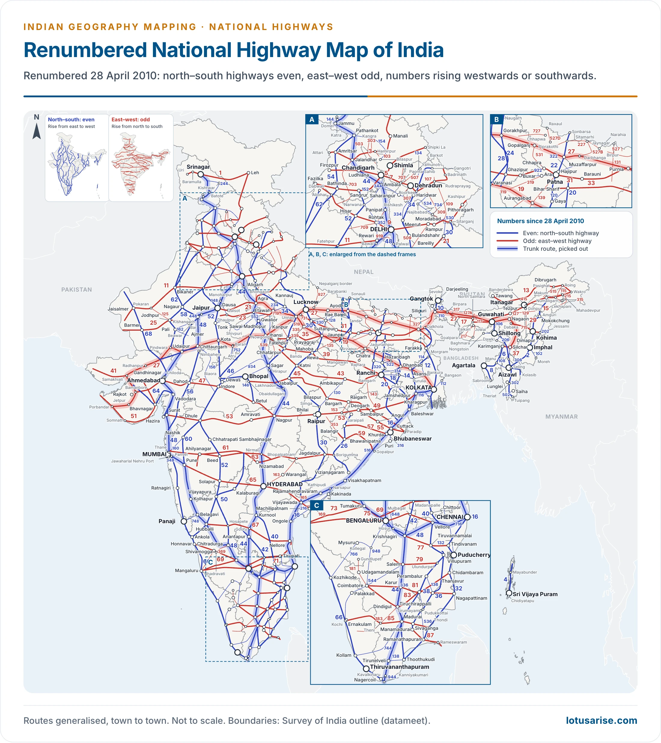
- The ministry published a new numbering system on 28 April 2010, in the Gazette of India. It rests on orientation and position.
- North–south highways carry even numbers, and these rise from east to west.
- A north–south highway in central or western India has a higher number than one in eastern India.
- NH-2 in the north-east is therefore low, and NH-68 in the far west is high.
- East–west highways carry odd numbers, and these rise from north to south.
- Major highways have one or two digits.
- Three-digit numbers are secondary routes, or branches of a main highway.
- NH-144, NH-244 and NH-344 are all branches of NH-44.
- Suffixes A, B, C, D and so on mark very small spin-offs or stretches of the sub-highways, as in NH-966A and NH-527B.
| Number form | Meaning | Example |
|---|---|---|
| Even, one or two digits | Main north–south road, rising east to west | NH-44, NH-48 |
| Odd, one or two digits | Main east–west road, rising north to south | NH-1, NH-27 |
| Three digits | Branch of the main road named by the last two digits | NH-144, NH-244 |
| Three digits with a letter | Very small spin-off of a branch | NH-966A, NH-527B |
National Highways Authority of India
- NHAI was set up under the National Highways Authority of India Act, 1988, and began operating on 10 February 1995. It is an autonomous authority under the administrative control of the Ministry of Road Transport and Highways.
- It was entrusted with the National Highways Development Project (NHDP), along with other minor projects for development, maintenance and management.
- NHDP upgrades, rehabilitates and widens major highways to a higher standard. The project dates from 1998, with its foundation stone laid on 6 January 1999.
- Its Golden Quadrilateral and north–south and east–west corridors shaped today’s trunk network.
- Its stated aim is to keep the network to global standards in a cost-effective way, and so to promote the economic well-being and quality of life of the people.
- What it has built: 3,979 km in 2019–20, 5,614 km in 2024–25 and 5,313 km in 2025–26, against a target of 4,640 km.
Bharatmala Pariyojana
- It is an umbrella programme for the highways sector. It seeks to make freight and passenger movement more efficient by bridging critical gaps in infrastructure.
- Six interventions drive it:
- Economic Corridors, and Inter Corridors and Feeder Routes.
- National Corridor Efficiency Improvement.
- Border and International connectivity roads.
- Coastal and Port connectivity roads.
- Green-field expressways.
- NHAI was mandated to develop about 27,500 km of Phase I. The whole of Phase I was set at 34,800 km.
- Position: of 26,425 km awarded, 22,709 km had been built by May 2026, as reported to Parliament. The ministry expects Phase I to finish by 2027–28.
List of Important National Highways
- Each row gives the old number, the number since 2010 and the present route.
- Where an old highway was split, the table gives the part that went to the new number.
Golden Quadrilateral and Trunk Roads
| Old number | New number | Present route | States and Union Territories |
|---|---|---|---|
| NH 2 | NH 19 (Golden Quadrilateral) | Agra–Prayagraj (Allahabad)–Varanasi–Dankuni, near Kolkata | Uttar Pradesh, Bihar, Jharkhand, West Bengal |
| NH 5, NH 6, NH 60, NH 217 | NH 16 (Golden Quadrilateral) | Kolkata–Bhubaneswar–Visakhapatnam–Chennai | West Bengal, Odisha, Andhra Pradesh, Tamil Nadu |
| NH 8 | NH 48 (Golden Quadrilateral) | Delhi–Jaipur–Ahmedabad–Mumbai–Bengaluru–Chennai | Delhi, Haryana, Rajasthan, Gujarat, Maharashtra, Karnataka, Tamil Nadu |
| NH 17, NH 47 | NH 66 (parallel to the Western Ghats) | Panvel (Navi Mumbai)–Mangaluru–Kochi–Kanniyakumari | Maharashtra, Goa, Karnataka, Keralam (Kerala), Tamil Nadu |
| NH 9 | NH 65 | Pune–Hyderabad–Vijayawada–Machilipatnam | Maharashtra, Karnataka, Telangana, Andhra Pradesh |
- Old NH 2 began at Delhi. Its stretch through Delhi and Haryana to Agra is now NH-44.
- The fourth side of the Golden Quadrilateral therefore runs on NH-19 and NH-44 together.
North and North-West
| Old number | New number | Present route | States and Union Territories |
|---|---|---|---|
| NH 1A, NH 1D | NH 1 | Uri–Srinagar–Kargil–Leh | Jammu and Kashmir, Ladakh |
| NH 1B | NH 244 | Khanabal–Batote | Jammu and Kashmir |
| NH 21, NH 22, NH 95 | NH 5 | Firozpur–Chandigarh–Shimla–Shipki La | Punjab, Chandigarh, Haryana, Himachal Pradesh |
| NH 11 | NH 21 | Jaipur–Bareilly | Rajasthan, Uttar Pradesh |
| NH 11A | NH 148 | Manoharpur–Lalsot | Rajasthan |
| NH 79 | NH 156 | Chittaurgarh–Mandsaur–Ratlam–Manpur | Rajasthan, Madhya Pradesh |
| NH 2A | NH 519 | Sikandra–Ghatampur–Chaudagra | Uttar Pradesh |
| NH 7 | NH 135 | Near Mirzapur–Mangawan | Uttar Pradesh, Madhya Pradesh |
| NH 24 | NH 530 | Rampur–Bareilly, and on towards Pantnagar | Uttar Pradesh |
| NH 56 | NH 731 | Lucknow–Jaunpur | Uttar Pradesh |
| NH 12 | NH 45 | Obaidullaganj–Jabalpur–Bilaspur | Madhya Pradesh, Chhattisgarh |
East and North-East
| Old number | New number | Present route | States and Union Territories |
|---|---|---|---|
| NH 2B | NH 114 | Barddhaman–Bolpur–Mallarpur | West Bengal |
| NH 35 | NH 112 | Barasat–Bangaon–Petrapole border | West Bengal |
| NH 55 | NH 110 | Siliguri–Kurseong–Darjeeling | West Bengal |
| NH 23 | NH 320 | Ormanjhi–Chas | Jharkhand |
| NH 30 | NH 319 | Mohania–Ara | Bihar |
| NH 39 | NH 129 | Numaligarh–Dimapur | Assam, Nagaland |
| NH 152 | NH 127A | Simlaguri–Bhutan border, by Manas National Park | Assam |
| NH 38, NH 153 | NH 315 | Makum–Ledo–Lekhapani–Myanmar border | Assam, Arunachal Pradesh |
West, South and the Islands
| Old number | New number | Present route | States and Union Territories |
|---|---|---|---|
| NH 3, NH 50 | NH 60 | Dhule–Nashik–Pune | Maharashtra |
| NH 4B | NH 348 | Palaspe–Jawaharlal Nehru Port | Maharashtra |
| NH 4A | NH 748 | Belagavi (Belgaum)–Panaji | Karnataka, Goa |
| NH 8A | NH 41 | Samakhiali–Narayan Sarovar | Gujarat |
| NH 8C | NH 147 | Doliya–Chiloda | Gujarat |
| NH 8D | NH 151 | Gadu–Jetpur | Gujarat |
| NH 18, NH 4 | NH 40 | Kurnool–Chittoor–Ranipet | Andhra Pradesh, Tamil Nadu |
| NH 7A | NH 138 | V. O. Chidambaranar (Tuticorin) Port–Tirunelveli | Tamil Nadu |
| NH 47 | NH 544 | Salem–Coimbatore–Kochi | Tamil Nadu, Keralam |
| NH 47A | NH 966B | NH 66–Willingdon Island, Kochi | Keralam |
| NH 47C | NH 966A | Kalamassery–Vallarpadam | Keralam |
| NH 223 | NH 4 | Saddle Peak–Sri Vijaya Puram (Port Blair)–Chidiyatapu | Andaman and Nicobar Islands |
- Aurangabad is now Chhatrapati Sambhajinagar and Ahmednagar is Ahilyanagar.
Other Main Highways of the Present Scheme
| New number | Route | States and Union Territories |
|---|---|---|
| NH 27 | Porbandar–Udaipur–Jhansi–Muzaffarpur–Guwahati–Silchar: the East–West Corridor | Gujarat, Rajasthan, Madhya Pradesh, Uttar Pradesh, Bihar, West Bengal, Assam |
| NH 52 | Sangrur–Jaipur–Indore–Dhule–Ankola | Punjab, Haryana, Rajasthan, Madhya Pradesh, Maharashtra, Karnataka |
| NH 30 | Sitarganj–Bareilly–Prayagraj–Raipur–Vijayawada | Uttarakhand, Uttar Pradesh, Madhya Pradesh, Chhattisgarh, Telangana, Andhra Pradesh |
| NH 53 | Hazira–Dhule–Nagpur–Raipur–Paradip Port | Gujarat, Maharashtra, Chhattisgarh, Odisha |
| NH 34 | Gangotri–Lakhnadon | Uttarakhand, Uttar Pradesh, Madhya Pradesh |
| NH 3 | Attari–Manali–Leh | Punjab, Himachal Pradesh, Ladakh |
| NH 2 | Dibrugarh–Kohima–Imphal–Aizawl–Tuipang | Assam, Nagaland, Manipur, Mizoram |
| NH 9 | Fazilka–Delhi–Rampur–Jauljibi | Punjab, Haryana, Delhi, Uttar Pradesh, Uttarakhand |
NH-1
- National Highway 1 (NH 1) runs between the Union Territories of Jammu and Kashmir and Ladakh.
- It comprises parts of the old NH 1A and NH 1D.
- The number 1 marks it, under the new system, as the northernmost east–west highway in India.
Routes of the Old Numbers
- The numbers in use before 2010 still fill older maps. The routes and lengths below are those of the old scheme, with current place names.
| Old number | Route | Length (km) |
|---|---|---|
| 1 | Delhi–Ambala–Jalandhar–Amritsar | 456 |
| 1A | Jalandhar–Madhopur–Jammu–Srinagar–Baramulla–Uri | 663 |
| 1B | Batote–Doda–Kishtwar | 107 |
| 2 | Delhi–Mathura–Agra–Kanpur–Prayagraj–Varanasi–Mohania–Barhi–Kolkata | 1,490 |
| 3 | Agra–Gwalior–Shivpuri–Indore–Dhule–Nashik–Thane–Mumbai | 1,161 |
| 4 | Thane–Pune–Belagavi–Hubballi–Bengaluru–Ranipet–Chennai | 1,235 |
| 4A | Belagavi–Anmod–Ponda–Panaji | 153 |
| 5 | Baharagora–Cuttack–Bhubaneswar–Visakhapatnam–Vijayawada–Chennai | 1,533 |
| 6 | Dhule–Nagpur–Raipur–Sambalpur–Baharagora–Kolkata | 1,645 |
| 7 | Varanasi–Rewa–Jabalpur–Nagpur–Hyderabad–Bengaluru–Madurai–Kanniyakumari | 2,369 |
| 8 | Delhi–Jaipur–Ajmer–Udaipur–Ahmedabad–Vadodara–Mumbai | 1,428 |
| 9 | Pune–Solapur–Hyderabad–Vijayawada | 791 |
| 10 | Delhi–Fazilka | 403 |
| 11 | Agra–Bharatpur–Jaipur–Bikaner | 582 |
| 12 | Jabalpur–Bhopal–Kota–Bundi–Jaipur | 890 |
| 13 | Solapur–Chitradurga | 491 |
| 14 | Beawar–Sirohi–Radhanpur | 450 |
| 15 | Pathankot–Bathinda–Bikaner–Jaisalmer–Barmer–Samakhiali | 1,526 |
| 16 | Nizamabad–Jagdalpur | 460 |
| 17 | Panvel–Mangaluru–Edappally | 1,269 |
| 18 | Kurnool–Nandyal–Kadapa (Cuddapah)–Chittoor | 369 |
| 20 | Pathankot–Mandi | 220 |
| 21 | Chandigarh–Ropar–Mandi–Kullu–Manali | 323 |
| 22 | Ambala–Kalka–Shimla–Narkanda–Rampur–Chini | 462 |
| 23 | Chas–Ranchi–Rourkela–Talcher | 459 |
| 24 | Delhi–Bareilly–Lucknow | 438 |
| 25 | Lucknow–Kanpur–Jhansi–Shivpuri | 319 |
| 26 | Jhansi–Lakhnadon | 396 |
| 27 | Prayagraj–Mangawan | 93 |
| 28 | Barauni–Muzaffarpur–Gorakhpur–Lucknow | 570 |
| 28A | Pipra–Sagauli–Raxaul | 68 |
| 29 | Gorakhpur–Ghazipur–Varanasi | 198 |
| 30 | Mohania–Patna–Bakhtiyarpur | 230 |
| 31 | Bakhtiyarpur–Siliguri–Nalbari–Amingaon | 1,125 |
| 31A | Sevoke–Gangtok | 92 |
| 32 | Govindpur–Dhanbad–Jamshedpur | 179 |
| 33 | Barhi–Ranchi | 352 |
| 34 | Dalkhola–Barasat–Kolkata | 443 |
| 35 | Barasat–Bangaon | 61 |
| 36 | Nagaon–Dabaka–Dimapur | 170 |
| 37 | Goalpara–Guwahati–Kamargaon–Saikhoaghat | 680 |
| 38 | Makum–Ledo–Lekhapani | 54 |
| 39 | Numaligarh–Imphal–Palel | 436 |
| 40 | Jorhat–Shillong–Dawki | 161 |
| 41 | Kolaghat–Haldia | 51 |
| 42 | Sambalpur–Angul–Cuttack | 261 |
| 43 | Raipur–Vizianagaram | 560 |
| 44 | Shillong–Passi–Badarpur–Agartala | 495 |
| 45 | Chennai–Tiruchirappalli–Dindigul | 387 |
| 46 | Krishnagiri–Ranipet | 132 |
| 47 | Salem–Coimbatore–Thiruvananthapuram–Kanniyakumari | 640 |
| 48 | Bengaluru–Hassan–Mangaluru | 328 |
| 49 | Kochi–Madurai–Dhanushkodi | 440 |
| 50 | Nashik–Pune | 192 |
| 51 | Paikan–Tura–Dalu | 149 |
| 52 | Baihata Chariali–Tezpur–Lakhimpur–Saikhoaghat | 850 |
| 53 | Badarpur–Jirighat–Silchar–Imphal | 320 |
| 54 | Silchar–Aizawl | 560 |
| 55 | Siliguri–Darjeeling | 77 |
| 56 | Lucknow–Varanasi | 285 |
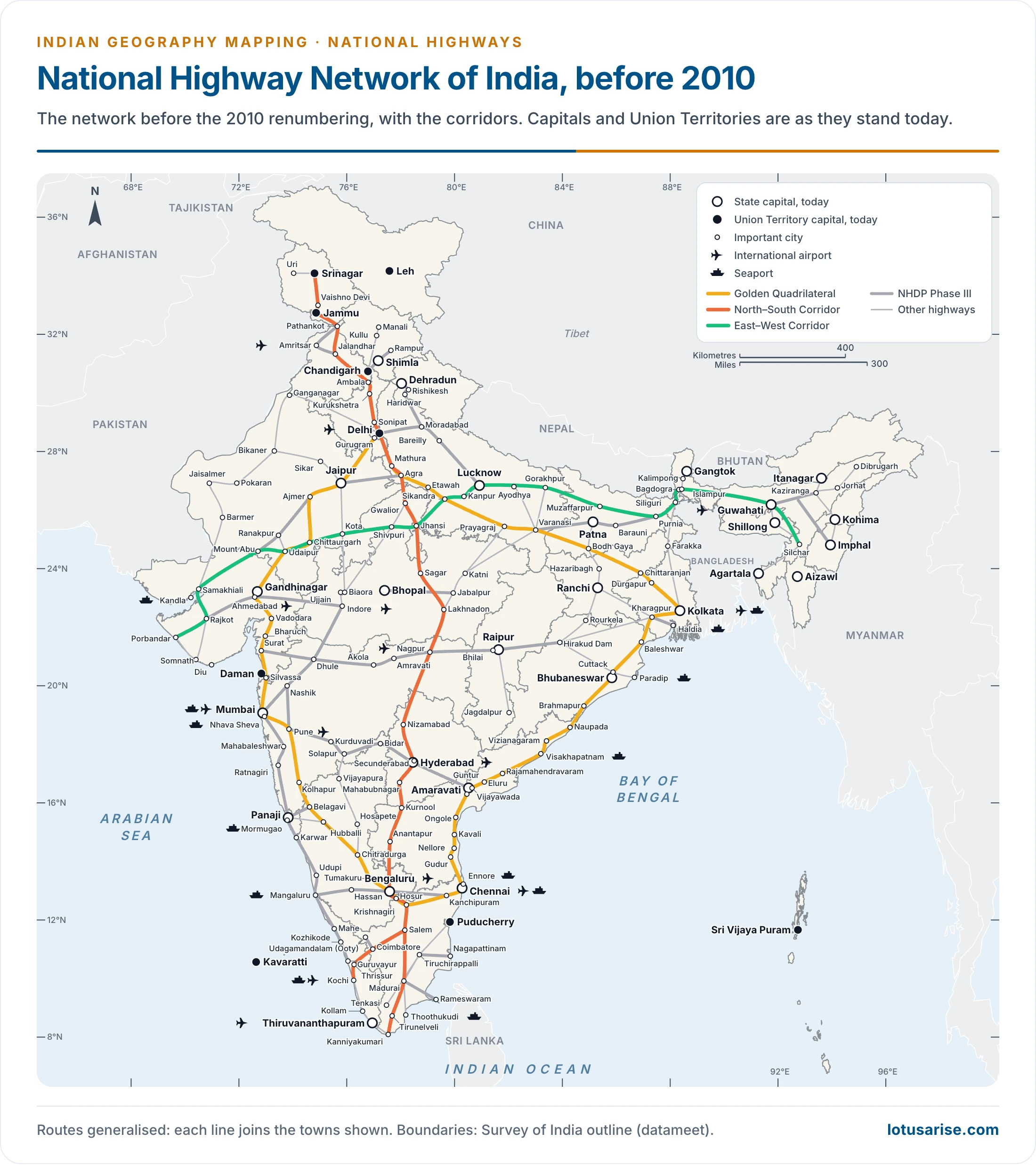
- Daman and Diu and Dadra and Nagar Haveli have formed one Union Territory since January 2020. Ladakh has been a separate Union Territory since October 2019.
Previous Year Questions
2013Map item: National Highway No. 24





Thank You So Much For This
❤️✨
Sir, Is this fully updated
went through roads of india from lotusarise and then this chapter.
very detailed and precise