

- Agriculture is the purposeful tending of crops and livestock. It is the oldest and most widespread economic activity, and the combined outcome of physical, economic, technical, social and cultural factors.
- Because these factors vary from place to place, farming across the world is neither uniform nor equal. Grouping farms that work in similar ways gives agricultural systems and agricultural regions.
- An agricultural typology classifies these systems into types. The most widely used world typology is that of Derwent Whittlesey (1936), who divided the world into 13 agricultural regions using five functional criteria.
Agriculture and Agricultural Regions

World Agriculture Today
- Agriculture uses a little over one-third of the world’s land area, most of it as permanent meadows and pastures and the rest as cropland.
- It employed about 26% of the world’s workers in 2022, down from 40% in 2000. The share is over 50% in many sub-Saharan countries, about 46% in India (PLFS 2023–24) and under 5% in most developed countries.
- Global agricultural value added reached about US$3.8 trillion in 2022 (FAO), close to 4% of world GDP. Its importance for food security, trade, raw materials and rural livelihoods is far greater than this share suggests.
- Agriculture is also a cultural, ecological and geopolitical activity. It shapes diets, landscapes and settlement patterns, and it is central to land degradation, water use and climate change.
Evolution of World Agriculture
- Neolithic Revolution (from about 10,000 BCE): domestication of plants and animals in several hearths: the Fertile Crescent, the Indus valley, China, Mesoamerica and the Andes.
- Agricultural diffusion: rice spread across Asia, wheat from West Asia into Europe, and maize, potato and cassava from the Americas to Europe, Asia and Africa after 1492 (the Columbian Exchange).
- Colonial period: plantation agriculture and cash crops (sugarcane, cotton, coffee, tea, rubber) were tied into world trade.
- Agricultural Revolution in Europe (18th–19th centuries): crop rotation, enclosures, selective breeding and later mechanisation laid the base of commercial mixed and dairy farming.
- Green Revolution (from the mid-1960s): high-yielding varieties, irrigation and chemical fertilisers raised yields sharply in Asia and Latin America, India included.
- 21st century: biotechnology, precision and digital farming, protected cultivation, vertical farming and climate-resilient agriculture; at the same time, global value chains link small farmers to supermarkets.
Factors Shaping Agricultural Characteristics
| Group | Factors | How they act | Examples |
|---|---|---|---|
| Physical | Climate (temperature, length of growing season, amount and season of rainfall), soil, relief, water | Set the limits of what can be grown and how | Rice in the wet tropics; winter wheat in Mediterranean lands; mechanised farming on flat plains; terraces on slopes |
| Demographic | Population density, labour supply | Dense populations favour labour-intensive subsistence farming; sparse ones favour extensive mechanised farming | Monsoon Asia vs the Great Plains, Pampas and Australia |
| Economic | Capital, markets, transport, prices | Decide intensity and market orientation | Dairy and horticulture near large cities; grain farms far inland on railways |
| Technological | Machinery, HYVs, fertilisers, irrigation, refrigeration | Raise productivity and extend farming into new lands | Refrigerated shipping opened New Zealand dairying and Argentine beef to Europe |
| Socio-cultural | Food habits, religion, tradition, land tenure | Affect crop and livestock choices | Cattle kept mainly for draught and milk in India; pig rearing absent in Muslim lands |
| Political | Colonial history, land reforms, subsidies, trade policy | Redirect farming towards particular crops and markets | Rubber in Malaya under British rule; EU Common Agricultural Policy; MSP in India |
- Political and economic history often explains patterns better than climate. The US Cotton Belt expanded on enslaved African labour; Southeast Asian rubber was planted for British and Dutch industry; Australia and New Zealand became pastoral exporters to Britain.
Agricultural Region, System and Typology
- An agricultural region is a continuous area with similar functional attributes of agriculture: crops, livestock, methods, inputs, output and the farmer’s way of life, set apart from surrounding areas.
- An agricultural system is a broader functional term. It may be a single farm or a group of interrelated farms that work in the same way.
- Agricultural typology groups farms or areas into types on chosen criteria. Agricultural regionalisation draws the boundaries of those types on a map.
- Classifying world agriculture is difficult because physical and human factors vary greatly and reliable data are often missing. Every typology simplifies.
Whittlesey’s Classification of Agricultural Regions (1936)
The Five Functioning Forms
- Derwent Whittlesey (1890–1956), an American geographer at Harvard, published Major Agricultural Regions of the Earth in the Annals of the Association of American Geographers (1936). It was the first systematic, global classification of agriculture.
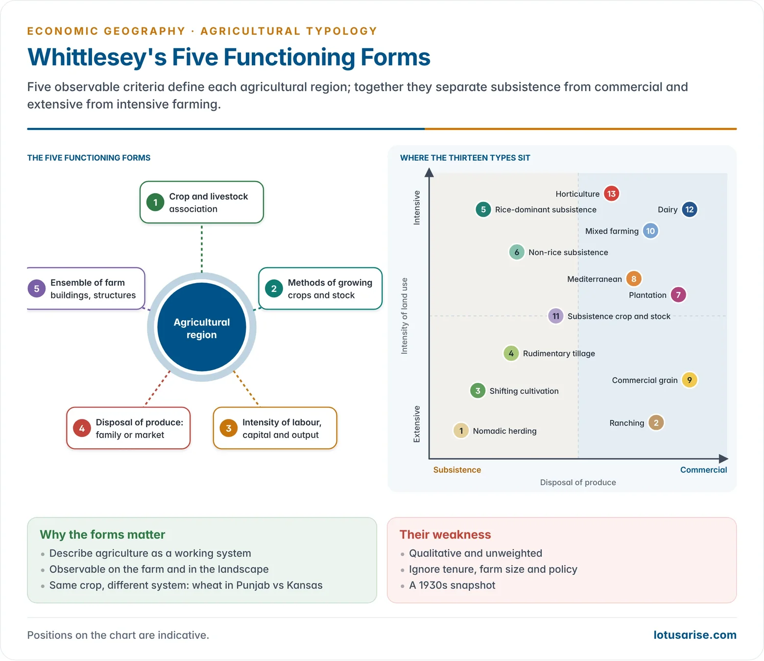
- He used five functional forms (criteria) that can be observed on the farm and in the landscape:
- Crop and livestock association: which crops and animals are combined, and in what proportion.
- Methods used to grow crops and produce stock: hand tools, draught animals, machines; shifting or permanent fields; irrigation.
- Intensity of application of labour, capital and organisation to the land, and the resulting output (productivity).
- Disposal of the products for consumption: for the family (subsistence) or for sale (commercial).
- The ensemble of structures used to house and facilitate farming: dwellings, barns, sheds, silos, fences and their layout.
- Significance of the five forms:
- They describe agriculture as a working system, not just as a crop map. The same crop (wheat) appears in different regions depending on method, intensity and market.
- Each form is observable and partly measurable, so types can be mapped and compared across continents.
- Together they combine physical (crops, livestock) and socio-economic (capital, labour, market) attributes.
- The ensemble of structures links agriculture to settlement and landscape: the scattered farmsteads and silos of the Corn Belt, the compact villages of Monsoon Asia, the estate lines of a tea garden.
- Their weakness is that they are qualitative and unweighted. Whittlesey did not say how much each form counts, so boundaries are judgemental.
The Thirteen Agricultural Regions
| No. | Type | Orientation | Intensity | Main regions |
|---|---|---|---|---|
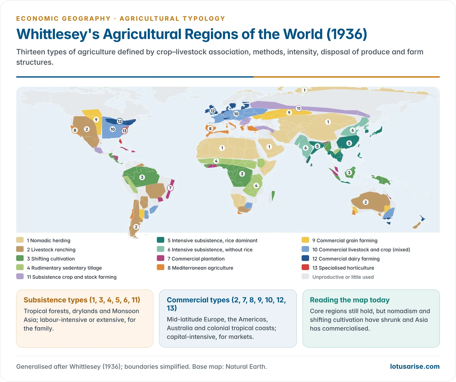
| 1 | Nomadic herding | Subsistence | Extensive | Sahara and Sahel, Arabia, Central Asia, Mongolia, Tibet, Horn of Africa, Arctic tundra |
| 2 | Livestock ranching | Commercial | Extensive | Western US, northern Mexico, Patagonia, interior Australia, New Zealand, South Africa |
| 3 | Shifting cultivation | Subsistence | Extensive | Amazon basin, Congo basin, West Africa, Southeast Asian islands, north-east India |
| 4 | Rudimentary sedentary tillage | Subsistence | Low | Tropical Africa, Central and South America, Southeast Asia |
| 5 | Intensive subsistence tillage, rice dominant | Subsistence | Very intensive | South and South-east China, Bengal, eastern and coastal India, Indochina deltas, Japan, Korea, Java |
| 6 | Intensive subsistence tillage, without rice | Subsistence | Intensive | North China Plain, Manchuria, interior and north-west India, Pakistan |
| 7 | Commercial plantation | Commercial | Intensive (capital) | Tropical coasts of Asia, Africa, Latin America and the Caribbean |
| 8 | Mediterranean agriculture | Commercial | Intensive | Mediterranean basin, California, central Chile, South Africa’s Cape, south-west and south Australia |
| 9 | Commercial grain farming | Commercial | Extensive | Great Plains of the US and Canada, Pampas, Eurasian steppes, Australian wheat belt |
| 10 | Commercial livestock and crop (mixed) farming | Commercial | Intensive | Western and central Europe, eastern US Corn Belt, Pampas, south-east Australia, South Africa |
| 11 | Subsistence crop and stock farming | Subsistence | Moderate | Eastern Europe and Russia (as mapped in 1936), parts of West Asia and highland Mexico |
| 12 | Commercial dairy farming | Commercial | Very intensive | North-western Europe, the US Great Lakes and north-east, south-east Canada, south-east Australia, New Zealand |
| 13 | Specialised horticulture | Commercial | Very intensive | US Atlantic and Gulf coasts, California, north-western Europe; patches near large cities |
1. Nomadic Herding
- An extensive, subsistence system of grazing animals on natural pastures, with herders moving seasonally in search of water and grass.
- Regions: the Sahara and its Sahel margins (Mauritania, Mali, Niger, Chad, Sudan), Arabia, Iran–Afghanistan, Central Asia, Mongolia, the Tibetan Plateau, the Horn of Africa, and the Arctic tundra (reindeer herding by the Sami of northern Scandinavia and herders of northern Russia).
- Characteristics:
- Closely tied to the natural environment; animals supply food, clothing, shelter and transport.
- Mixed herds suit local conditions: camels and goats in deserts, yaks in Tibet, reindeer in the tundra, cattle among the Maasai of East Africa.
- Transhumance in mountains: herds move to high pastures in summer and down to valleys in winter, as the Gujjars and Bakarwals of Jammu and Kashmir and the Gaddis of Himachal Pradesh do.
- Examples: the Bedouin of Arabia, the Tuareg of the Sahara, Mongol herders, Tibetan yak herders.
- Present status: shrinking, as states settle nomads, borders cut migration routes, ranches and irrigation take over grazing lands, and droughts hit the Sahel and Horn of Africa.
2. Livestock Ranching
- Extensive commercial grazing on permanent, fenced ranches in semi-arid grasslands of the New World and the Southern Hemisphere. Cattle, sheep and goats are raised for the market.
- Regions: western US and Canada, northern Mexico, the Pampas and Patagonia (Argentina), Uruguay, interior Brazil, the Australian Outback, New Zealand, the Karoo and Highveld of South Africa.
- Characteristics:
- Settled ranchers working individually, with scientific management: fencing, water bores, veterinary care, selective breeding.
- Specialisation in animal products (beef, wool, mutton, hides); little cropping.
- Ranching opened up new lands and drove the growth of railways, meat-packing towns and refrigerated ports.
- Examples: cattle ranching in the Pampas and the US high plains; sheep stations for Merino wool in Australia.
- Present status: expanding cattle ranching in the Brazilian Amazon and Cerrado is a leading driver of deforestation.
3. Shifting Cultivation
- A land-rotation system, known as slash-and-burn: farmers clear a forest patch by cutting and burning, cultivate it for a few years until fertility falls, then move to a new patch and leave the old one to regrow.
- Regions: the Amazon basin, Central America, the Congo basin and West Africa, Southeast Asian islands (Borneo, Sumatra, New Guinea), the hill tracts of Myanmar and north-east India.
- Regional names:
| Name | Region |
|---|---|
| Jhum | North-east India |
| Ladang | Indonesia and Malaysia |
| Milpa | Mexico and Central America |
| Kaingin | Philippines |
| Conuco | Venezuela |
| Roça | Brazil |
| Masole | Congo basin |
| Ray | Vietnam |
- Characteristics:
- Field rotation, not crop rotation; ash fertilises the soil.
- Short cropping (2–3 years) and, traditionally, a long fallow of 10–20 years. Population pressure has cut the jhum cycle in north-east India to as little as 3–5 years, so soils cannot recover.
- Crops: upland rice, maize, millets, cassava, yams, vegetables; mainly for family use.
- Present status: declining through deforestation, population growth and government programmes for settled farming, terracing and plantations (oil palm, rubber, areca).
4. Rudimentary Sedentary Tillage
- Subsistence farming on permanent fields in the tropics, a step beyond shifting cultivation. Fields are used year after year, with periodic fallowing and crop rotation.
- Regions: savanna and highland tropical Africa, parts of Central and South America, Southeast Asia.
- Characteristics:
- Animals are used for draught, milk and meat.
- Crops: maize, millets, sorghum, upland rice; root crops (cassava, yams, sweet potato); tree crops (bananas, oil palm, rubber).
- Low capital and low yields; small surpluses sold in local markets.
- Present status: being absorbed into commercial smallholder farming as roads, markets and cash crops spread.
5. Intensive Subsistence Tillage with Rice Dominant
- The farming system of Monsoon Asia. It feeds the densest rural populations on earth on very small holdings, because wet rice gives high yields per hectare and absorbs large amounts of labour.
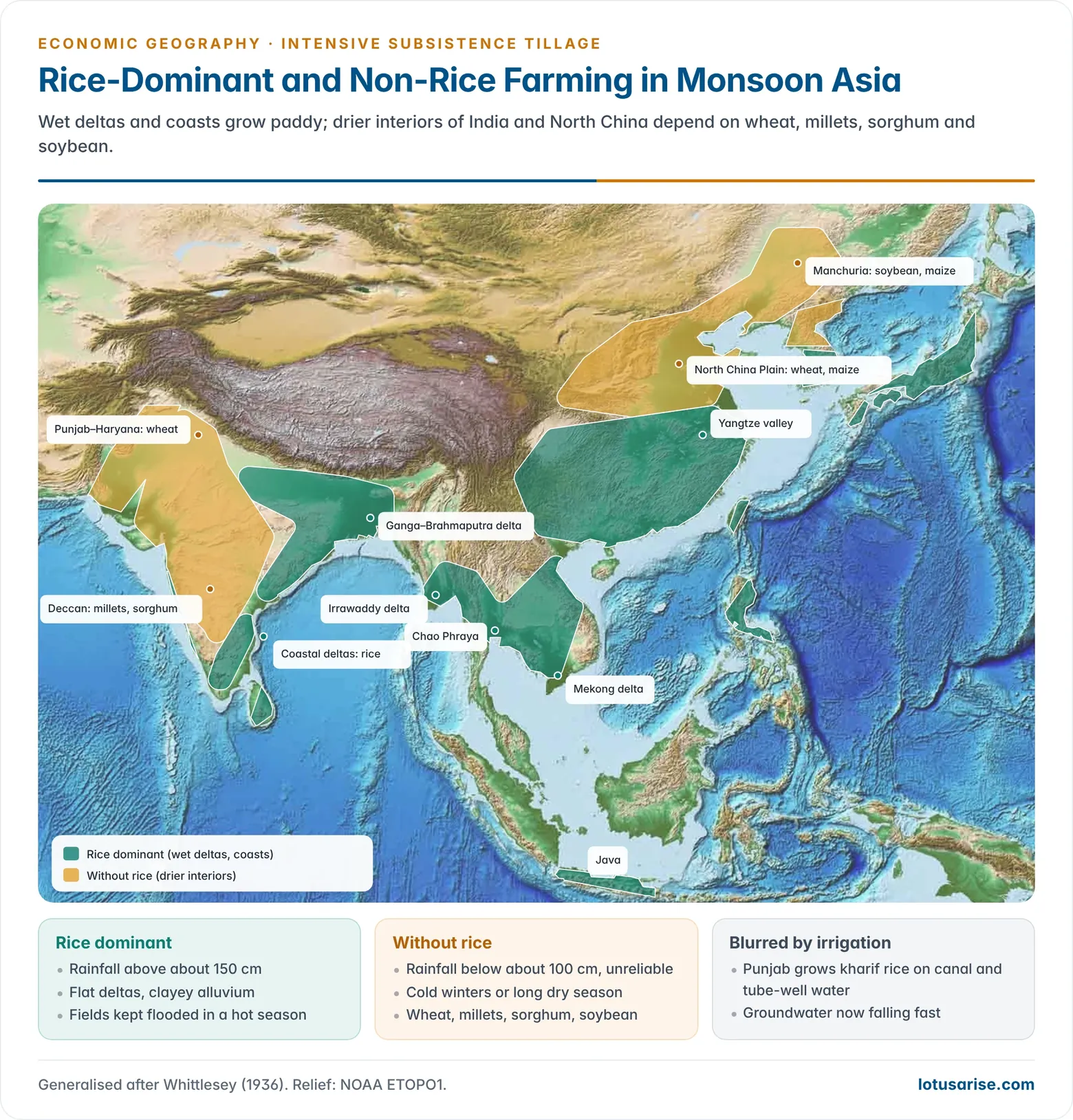
- Regions: South and South-east China (Yangtze valley and southwards), the Ganga–Brahmaputra delta, eastern and coastal India, the deltas of the Mekong, Chao Phraya, Irrawaddy and Red River, Java, the Philippines, Japan, South Korea, Sri Lanka.
- Characteristics:
- Double or triple cropping; rice in the wet season, with pulses, oilseeds, jute, vegetables or sugarcane in the dry season.
- Heavily labour-intensive: transplanting, weeding and harvesting by hand, with buffaloes and oxen for ploughing. Machinery is spreading fast in China, Japan and India.
- Small, fragmented holdings, intensive use of farmyard manure and, since the Green Revolution, HYVs, hybrid rice and fertilisers.
- Terraced fields on slopes (Ifugao terraces of the Philippines, Bali, Yunnan).
- Significance: the backbone of Asian food security. Asia produces about 90% of the world’s rice.
6. Intensive Subsistence Tillage without Rice Dominant
- The drier counterpart of system 5, where rainfall is too low or too seasonal for paddy. Labour-intensive and subsistence-oriented, but based on wheat, millets, barley, sorghum (kaoliang) and soybeans.
- Regions: the North China Plain and Manchuria, the loess plateau, north-west and interior India (Punjab–Haryana, western Uttar Pradesh, the Deccan), Pakistan.
- Characteristics:
- Small, fragmented farms; human and animal labour; manure and crop rotation.
- Vulnerable to erratic rainfall, droughts and crop failure; historically the zone of famines in North China and the Deccan.
- Irrigation (canals, tube wells), HYV wheat and fertilisers have transformed Punjab–Haryana and the North China Plain into surplus regions.
Why rice dominates in one and not the other
| Factor | Rice-dominant region | Region without rice |
|---|---|---|
| Rainfall | Over about 150 cm, concentrated in the monsoon; standing water possible | Under about 100 cm, unreliable; long dry season |
| Temperature | High through the growing season (above about 20–25 °C) | Cold winters (North China, Manchuria) or hot dry summers |
| Relief and soil | Flat deltas and flood plains with clayey, water-retentive alluvium | Loess, black and alluvial soils on higher, better-drained plains and plateaus |
| Water source | Monsoon floods, tanks, canals | Wells, tube wells, canals; often rainfed |
| Crops | Wet rice, jute, sugarcane | Wheat, millets, sorghum, barley, soybean, gram |
| Population | Extremely dense deltas | Dense but somewhat lower |
| Examples | Bengal delta, Yangtze, Mekong | Punjab, Deccan, North China Plain |
- The difference is thus essentially one of water: where rainfall or irrigation can keep fields flooded through a hot growing season, rice gives the highest return to land and labour. Elsewhere, drought-tolerant cereals take its place. Irrigation has blurred this line: Punjab now grows rice in the kharif season, at a heavy cost in groundwater.
7. Commercial Plantation Agriculture
- Large-scale, capital-intensive, export-oriented monoculture of tropical tree and bush crops on estates, developed under European colonial rule to supply industry and consumers in Europe.
- Regions and crops: tea in Assam, Darjeeling, the Nilgiris and Sri Lanka; rubber in Malaysia, Indonesia, Thailand; oil palm in Indonesia and Malaysia; cocoa in Côte d’Ivoire and Ghana; coffee in Brazil, Colombia, Vietnam; bananas in Central America and Ecuador; sugarcane in the Caribbean and Brazil.
- Characteristics:
- Large estates, often with their own processing factory, worker housing, roads and links to a port.
- Monoculture, scientific management and heavy use of fertilisers and pesticides.
- Historically foreign capital and cheap migrant labour: indentured Indian labour in Malaya, Sri Lanka, Fiji and the Caribbean.
- Problems: price volatility, pests and diseases, soil exhaustion, deforestation and labour exploitation.
- Present status: many estates have been nationalised or broken up. Smallholders now produce much of the world’s rubber, cocoa and oil palm, and the regional specialisation of plantation crops has shifted towards Southeast Asia and West Africa.
8. Mediterranean Agriculture
- A specialised commercial system of lands with hot, dry summers and mild, rainy winters, combining winter cereals, drought-resistant tree crops, irrigated horticulture and small livestock.
- Regions: lands around the Mediterranean Sea, California, central Chile, the Western Cape of South Africa, and south-west and south Australia (Perth, Adelaide).
- Characteristics:
- Winter wheat and barley grown on winter rain.
- Tree and vine crops with deep roots and waxy leaves: olives, grapes, figs, almonds, citrus. The region is called the “orchard of the world”.
- Summer irrigation for fruit and vegetables; growing use of greenhouses (Almería in Spain).
- Sheep and goats on rough hill land, with transhumance.
- Viticulture and wine-making: France, Italy and Spain are the leading wine producers.
- Significance: supplies citrus, out-of-season vegetables and wine to Europe and North America; increasingly threatened by drought, heat waves and wildfires linked to climate change.
9. Commercial Grain Farming
- Extensive, highly mechanised cultivation of grain, chiefly wheat, on very large farms in the mid-latitude grasslands, far from markets and with low population densities.
- Regions: the Great Plains and Canadian Prairies, the Pampas of Argentina, the steppes of Ukraine, southern Russia and Kazakhstan, and the wheat belts of New South Wales and Western Australia.
- Characteristics:
- Farms of hundreds to thousands of hectares; ploughing, sowing and harvesting by tractors and combine harvesters. Labour productivity is the highest of any system.
- Yields per hectare are moderate; fertiliser use is lower than in intensive systems and farming depends on rainfall.
- Produce moves by rail and through grain elevators to ports for export.
- Winter wheat belt in Kansas, Oklahoma and Texas (sown in autumn); spring wheat belt in the Dakotas, Montana and the Canadian Prairies (sown in spring because winters are too severe).
- Significance: the “granaries of the world” that supply the international grain trade. Russia has become the world’s leading wheat exporter.
10. Commercial Livestock and Crop Farming (Mixed Farming)
- The integration of crop cultivation and livestock rearing on the same commercial farm, in the humid middle latitudes. It is the characteristic system of Europe and spread with European settlement.
- Regions: Europe from Ireland across central Europe to western Russia; the eastern US and Canada east of about the 98th meridian, with the Corn Belt (Iowa, Illinois, Indiana) as its core; the eastern Pampas; south-east Australia; New Zealand; parts of South Africa.
- Characteristics:
- Crops (maize, wheat, barley, oats, potatoes, sugar beet, fodder) feed animals; manure feeds the soil. In the Corn Belt, maize and soybeans fatten cattle and pigs.
- Market-oriented, capital-intensive and mechanised, run by skilled farmers close to urban markets.
- Risk-spreading: losses in one enterprise are balanced by the other.
- Significance: one of the most productive and scientifically managed systems; its spatial arrangement around cities resembles the rings of Von Thünen’s model.
11. Subsistence Crop and Stock Farming
- Whittlesey’s type for areas where crops and livestock are raised mainly for the family, with little marketing, low capital and traditional techniques.
- Regions (as mapped in 1936): much of eastern Europe and the Soviet Union, parts of West Asia (Anatolia, Iran) and the highlands of Mexico. Similar systems persist in the hill and dry regions of India (Rajasthan, parts of the peninsula).
- Characteristics: rye, wheat, barley, maize, millets; sheep and goats; poor seed and stock; fertility kept up with manure, compost and fallow.
- Present status: Soviet collectivisation (from 1929) was already replacing peasant farms with collective and state farms as the map appeared. This is the clearest case of how political change makes a type out of date.
12. Commercial Dairy Farming
- The most capital- and labour-intensive form of livestock farming: cattle are reared for milk and milk products (butter, cheese, milk powder, condensed milk).
- Regions: north-western Europe (Denmark, the Netherlands, Britain, northern Germany, France, Switzerland, southern Scandinavia), the US Dairy Belt (Wisconsin, Minnesota, New York) and south-east Canada, New Zealand and south-east Australia (Victoria, Tasmania).
- Characteristics:
- Cool, moist climates with good pastures; fodder crops and silage for winter.
- Heavy investment in milking machines, refrigeration, silos and barns (Whittlesey’s “ensemble of structures”).
- Close to large urban markets, with fast transport and cooperatives (the Danish cooperative model, India’s Anand/Amul model).
- High yields from improved breeds such as Holstein-Friesian and Jersey: more than 10,000 kg of milk per cow a year in Denmark, against about 3,500 kg in Romania and Bulgaria (2023).
- Significance: New Zealand is the leading exporter of dairy products; India is the world’s largest milk producer, but from small herds, not commercial dairy farms of the Whittlesey type.
13. Specialised Horticulture
- Intensive commercial cultivation of vegetables, fruits and flowers, usually on small, high-value farms near large urban markets or along fast transport routes.
- Regions: the US Atlantic coast (truck farming), Florida, the Rio Grande valley and California; north-western Europe, especially the Netherlands (flowers, glasshouse vegetables); fruit valleys such as the Rhône, the Rhine and Mendoza; dates in West Asia; spices and tropical fruits in India and Southeast Asia.
- Characteristics:
- High inputs of labour, capital, fertilisers, irrigation and pesticides; growing use of glasshouses, hydroponics and cold chains.
- Strongly market-driven; perishable produce needs fast transport.
- Present status: now a global value chain: Kenyan and Ethiopian cut flowers, Chilean grapes and Indian grapes and mangoes are flown or shipped to distant markets, and the Netherlands is a leading exporter of food and flowers.
Merits of Whittlesey’s Classification
- First systematic world typology of agriculture; still the standard framework in atlases and textbooks.
- Functional basis: the five forms describe how farming works, not only what is grown.
- Observable and mappable: criteria can be checked in the field and partly measured.
- Comparative: allows generalisation across continents and comparison of regions.
- Integrative: combines physical and human factors in one scheme, in the tradition of regional geography.
- Flexible framework: later scholars refined and updated it rather than discarding it.
Limitations
- Qualitative and subjective: the five forms are not weighted or quantified, so boundaries are drawn by judgement.
- Neglect of institutional factors: land tenure, farm size, ownership (estates, collectives, family farms) and state policy are left out, though they decide how farming works.
- Static: it is a snapshot of the 1930s. It could not anticipate collectivisation, decolonisation, the Green Revolution, mechanisation in Asia or globalisation.
- Coarse scale: each world region hides large internal variations, as in India, where several types coexist within one state.
- Euro-American bias: commercial types of the mid-latitudes are subdivided finely, while varied tropical systems are lumped together.
- Unproductive lands (forests, deserts, ice) are left out, although many have since been brought into use.
Relevance Today
- Still valid in its broad pattern: the core areas of rice-based subsistence farming, mid-latitude grain, mixed and dairy farming, ranching and Mediterranean agriculture remain where Whittlesey put them. The five functioning forms remain a sound way to describe any farming system.
- Changes since 1936:
- Subsistence to commercial: the Green Revolution and markets have made Punjab, Haryana and the North China Plain surplus-producing regions.
- Decline of shifting cultivation and nomadism under population pressure, deforestation and state policy.
- Political transformations: collective farms in the USSR and China came and went; China’s Household Responsibility System (1978) restored family farming.
- New frontiers: soybean and maize in the Brazilian Cerrado, oil palm in Indonesia and Malaysia, irrigated agriculture in Saudi Arabia and Egypt’s desert margins.
- New systems that do not fit his scheme: contract farming, organic farming, protected cultivation, vertical farming and peri-urban dairying.
- Climate change is shifting crop belts poleward and upslope and increasing drought risk in the Mediterranean and semi-arid grain lands.
- Whittlesey’s scheme is therefore best used as a base map of agricultural systems, updated with modern data on tenure, technology and markets.
Other Typologies of World Agriculture
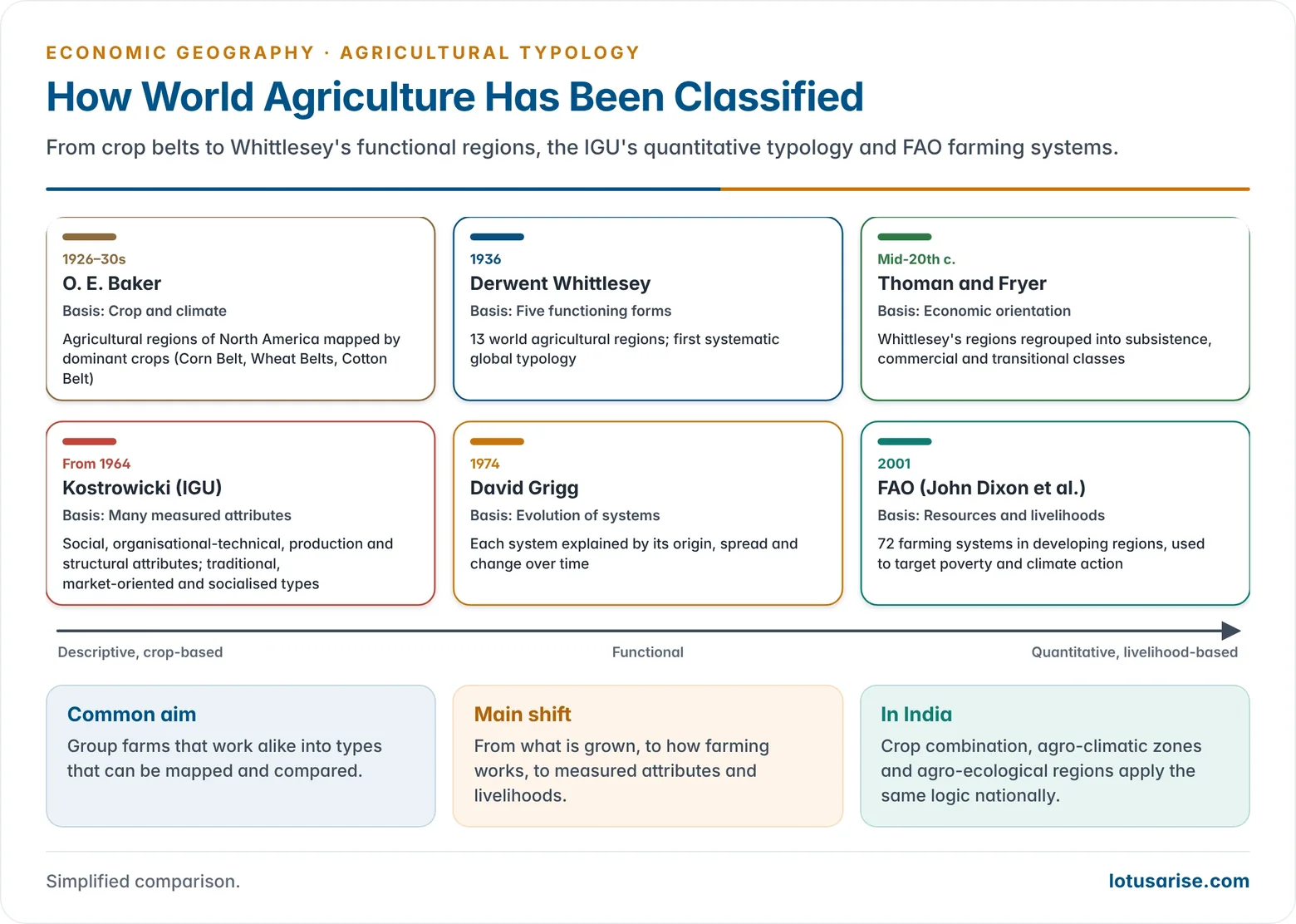
- Oliver Edwin Baker (1926–1930s) delineated the agricultural regions of North America mainly by crops and climate. This crop-based approach preceded Whittlesey’s functional one.
- Richard S. Thoman and Donald W. Fryer modified Whittlesey’s scheme for economic geography, grouping regions into broad classes such as subsistence, commercial and transitional agriculture.
- IGU Commission on Agricultural Typology (from 1964): led by Jerzy Kostrowicki of Poland, it built a typology from many measurable attributes in four groups: social (ownership, tenure, farm size), organisational-technical (labour, mechanisation, irrigation, fertiliser), production (land and labour productivity, commercialisation) and structural (crop and livestock mix). Its first-order types were traditional, market-oriented and socialised agriculture.
- David Grigg (1974), in The Agricultural Systems of the World: An Evolutionary Approach, explained each system historically: how it arose, spread and changed.
- FAO farming systems (2001): a study led by John Dixon identified 72 farming systems in the developing regions, grouped by resource base, dominant livelihood and market access. It is used to target poverty and climate-adaptation programmes.
- Indian studies of agricultural regionalisation by crop combination, agro-climatic zones and agro-ecological regions apply the same logic at the national scale.
Regional Patterns of World Agriculture
| Region | Dominant systems | Key crops and livestock | Distinctive features |
|---|---|---|---|
| South and East Asia | Intensive subsistence (rice and non-rice), plantations | Rice, wheat, tea, jute, rubber, oil palm | Monsoon-dependent, small holdings, Green Revolution gains; Asia grows about 90% of world rice |
| West Asia and North Africa | Irrigated farming, Mediterranean agriculture, nomadic herding | Wheat, barley, dates, cotton, citrus | Aridity; Nile, Tigris–Euphrates irrigation; Israel’s drip-irrigated horticulture |
| Europe | Mixed farming, dairy, Mediterranean, horticulture | Wheat, barley, sugar beet, grapes, olives, milk | Mechanised, subsidy-supported (Common Agricultural Policy); under 5% of workers in farming |
| North America | Commercial grain, mixed (Corn Belt), dairy, ranching, horticulture | Wheat, maize, soybeans, cotton, beef, milk, fruit | Specialised belts; about 2% of workers feed the continent and export a surplus |
| Latin America | Plantations, ranching, commercial grain and soybeans, subsistence farming | Coffee, sugarcane, soybeans, bananas, beef | Large estates beside smallholders; Brazil leads in coffee, sugar, soybeans and beef exports; Amazon deforestation |
| Sub-Saharan Africa | Shifting cultivation, rudimentary tillage, nomadic herding, plantation cash crops | Cassava, maize, millets, cocoa, coffee, tea | Low productivity, drought exposure; dual economy of subsistence and export crops |
| Australia and New Zealand | Ranching, commercial grain, dairy, Mediterranean | Wheat, wool, beef, milk, wine | Export-oriented, limited by aridity in Australia |
- Regional sub-patterns:
- South Asia: rice in the Ganga plains and coastal deltas; wheat in Punjab–Haryana and the Pakistan plains; cotton in the Deccan and Gujarat; jute in Bengal and Bangladesh; tea in Assam and Sri Lanka.
- East Asia: rice in the Yangtze valley and Pearl River delta; wheat and maize on the North China Plain; small-scale intensive farming and horticulture in Japan and Korea.
- Southeast Asia: wet rice in the Mekong, Irrawaddy and Red River deltas; rubber and oil palm in Malaysia and Indonesia; coffee in Vietnam, the world’s second-largest producer.
- Europe: mixed farming with cereals, sugar beet and dairy in the west and centre; the Netherlands leads in glasshouse horticulture and flowers; olives, grapes and citrus in the south; dairying in Scandinavia; wheat, sunflower and barley in Ukraine and southern Russia, the old “granary of Europe”.
- North America: the Corn Belt (maize and soybeans), Wheat Belts of the Great Plains, the old Cotton Belt of the South, the Dairy Belt of the Great Lakes and California’s fruit, vegetables and vineyards; wheat and canola on the Canadian Prairies.
- Latin America: soybeans in Mato Grosso; wheat, maize and beef in the Pampas; terrace farming of potatoes, quinoa and maize in the Andes; sugar, bananas and cocoa in the Caribbean and Central America.
- Africa: irrigated wheat, rice, cotton and sugarcane in the Nile valley; cocoa, oil palm and groundnut in West Africa; coffee, tea and cut flowers in Kenya and Ethiopia; maize and tobacco in Southern Africa; cassava and bananas in the Congo basin.
- Oceania: wheat belts of New South Wales and Western Australia, sheep stations in the interior, dairying in Victoria and Tasmania, vineyards in South Australia; dairy, sheep, kiwifruit and wine in New Zealand; root crops and coconuts on the Pacific islands.
- Common trends: commercialisation of subsistence systems, mechanisation, shrinking farm workforces, rising yields, consolidation of value chains by agribusiness, and growing exposure to climate risk.
- Persistent contrasts: labour-intensive, small-farm agriculture in Asia and Africa versus capital-intensive, large-farm agriculture in the Americas, Europe and Oceania. These reflect differences in population density, capital and history.
Previous Year Questions
2026Critically examine the significance of five functioning forms with regard to agricultural regions of the world proposed by D. Whittlesey.2024Explain the basis of D. Whittlesey’s classification of agricultural regions of the world.2017“Whittlesey’s agricultural regions are relevant even today.” Discuss.2011Mention the agricultural regions as classified by Whittlesey and discuss their relevance.2006Write down main agricultural types and their associated features with special reference to Whittlesey. Show these regions on the World map provided to you.1998Write short note: Types of Farming.1996Examine the bases of classification of agricultural regions as proposed by Whittlesey and explain the causes for the essential difference between intensive subsistence tillage with rice dominant and without rice in the crop association.1993Give an account of the agricultural typology of the world as presented by Whittlesey and critically examine the parameters used in its delineation.





Sir, Commercial Livestock & Crop Farming is wrong. Replace with Commercial Cropping & Livestock Farming.
Good
thank u very much….
Sir I’m not able to find any book for economic geography so your notes is sufficient?
there’s a book by Prithwish Roy
p.s. I’ve no blood relations with him
There are many mistakes in this article specially grammatical mistakes. Please rectify it.
Spelling mistakes are in a way I was unable to predict the correct word..
Updated!
Updated and rewritten the complete article again! Thanks
Amazing
Very well curated notes