

- Petroleum, or mineral oil, takes its name from the Latin petra (rock) and oleum (oil). It is an inflammable liquid drawn from sedimentary rocks, and hydrocarbons make up 90–95% of it.
- India’s estimated crude reserves were 672.07 million tonnes on 1 April 2025, while output in 2025-26 was only 28.0 million tonnes, against consumption of 243.2 million tonnes of petroleum products.
- Import dependence for crude stood at 88.7% in 2025-26, and this gap shapes the country’s refining, pipeline and strategic reserve geography.
Nature, Origin and Occurrence
Composition and Uses
- Crude petroleum is a mix of solid, liquid and gaseous hydrocarbons.
- It contains paraffins, some unsaturated hydrocarbons and a small benzene-group fraction.
- The remainder is chiefly organic compounds of oxygen, nitrogen and sulphur, with traces of organo-metallic compounds.
- Main use: motive power. This compact liquid fuel transformed movement on land, in the air and at sea.
- Easy to move: tankers carry it from producing to consuming regions, though pipelines do so more cheaply and efficiently.
- Advantage over coal: it gives very little smoke and no ash, and burns to the last drop.
- Other uses: it is the main source of lubricants, and a key feedstock for petrochemicals.
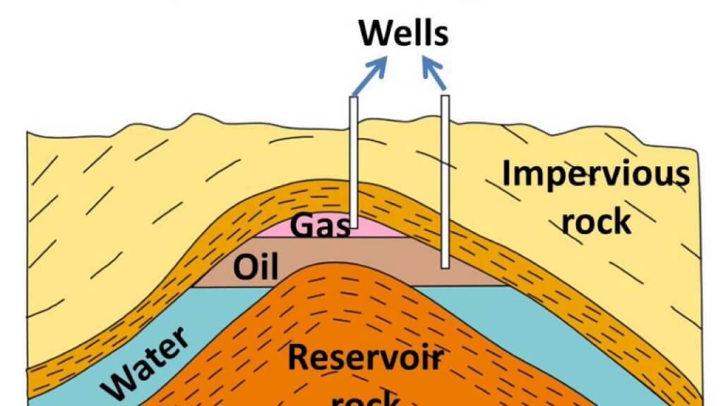
Origin and Occurrence
- Petroleum is of organic origin. Animal and plant remains, especially microscopic forms, settled in shallow marine sands, silts and clays, and decayed under burial.
- It occurs in sedimentary basins, shallow depressions and seas, past and present.
- Conditions were especially good in the lower and middle Tertiary, when dense forests and sea life flourished around gulfs, estuaries and deltas.
- Age in India:
- Most Indian oil sits in anticlines and fault traps of Tertiary rocks, which span 66 to 2.58 million years ago. The figure of about 3 million years often attached to them marks only the end of that span.
- Some recent sediments, under one million years old, show incipient oil.
- Where the world’s oil lies: older lists single out Miocene rocks, as at Mumbai High, and mildly folded rocks, where gentle anticlines keep traps intact.
- Three conditions make a reservoir:
- Porosity, to hold large amounts of oil.
- Permeability, to release oil or gas once a well is drilled.
- An impervious cap over the porous sandstones, conglomerates or fissured limestones, so that oil cannot seep away.
- Layering in a trap: oil is lighter than water, with a specific gravity of 0.8–0.98, and gas is lighter still. A well therefore meets gas first, then oil, then water, although a gas seep alone does not prove a reservoir.
Sedimentary Basins
- India has 26 sedimentary basins covering about 3.36 million sq km, according to the Ministry of Petroleum and Natural Gas.
- Older counts gave 27 basins, and about 14.1 lakh sq km of onshore sedimentary rock, 42% of the country.
- Seven Category I basins already produce commercially. They cover about 30% of the basinal area and hold about 85% of conventional hydrocarbons in place:
- Krishna-Godavari
- Mumbai Offshore
- Assam Shelf
- Rajasthan
- Cauvery
- Assam-Arakan Fold Belt
- Cambay
- Policy: the Hydrocarbon Exploration and Licensing Policy gave one licence for conventional and unconventional resources alike, with blocks offered through open acreage rounds.
- The Oilfields (Regulation and Development) Amendment Act, 2025 received assent on 28 March 2025. It delinks petroleum from mining and creates a single petroleum lease.
Reserves and Production
| Region | Reserves, 1 April 2025 (million tonnes) | Share (%) | Output share, 2011-12 (%) |
|---|---|---|---|
| Western Offshore | 209.30 | 31.14 | Offshore in all: 52.68 |
| Assam | 144.73 | 21.53 | 13.19 |
| Rajasthan | 136.46 | 20.30 | 17.20 |
| Gujarat | 121.20 | 18.03 | 15.16 |
| Eastern Offshore | 37.25 | 5.54 | Included in Offshore |
| Tamil Nadu | 9.11 | 1.36 | 0.65 |
| Andhra Pradesh | 8.41 | 1.25 | 0.81 |
| Arunachal Pradesh | 2.97 | 0.44 | 0.31 |
| Nagaland | 2.38 | 0.35 | – |
| Year | Onshore (million tonnes) | Offshore (million tonnes) | Total (million tonnes) |
|---|---|---|---|
| 1950-51 | 0.3 | – | 0.3 |
| 1970-71 | 6.8 | – | 6.8 |
| 1980-81 | 5.5 | 5.0 | 10.5 |
| 1990-91 | 11.8 | 21.2 | 33.0 |
| 2010-11 | 18.0 | 20.1 | 38.1 |
| 2013-14 | 19.54 | 18.19 | 37.78 |
| 2023-24 | – | – | 29.4 |
| 2024-25 | – | – | 28.7 |
| 2025-26 (provisional) | – | – | 28.0 |
- Three stages of output:
- Until the mid-1970s, all oil came from land, and India produced very little.
- Mumbai High then made offshore the leader, with about two-thirds of output from 1990-91 to 2009-10.
- Barmer then lifted onshore output again. National production has been falling since its peak of about 38 million tonnes.
Oilfields of India
North-East India
- The oil province of the Brahmaputra valley extends into Arunachal Pradesh, Nagaland, Tripura, Manipur, Mizoram and Meghalaya.
- Assam is the oldest producing State. Its main oil-bearing strata extend about 320 km through Upper Assam.
| Field | Location | Key dates | Details |
|---|---|---|---|
| Digboi | North-east of the Tipam hills; older Dibrugarh district | Oil struck 1889 | India’s oldest field; about 13 sq km; depths 400–2,000 m; over 800 wells |
| Naharkatiya | 32 km south-west of Digboi, left bank of the Burhi Dihing | Found 1953, producing 1954 | 60 successful wells: 56 oil, 4 gas |
| Moran-Hugrijan | About 40 km south-west of Naharkatiya | Found 1953, producing 1956 | 20 wells, giving both oil and gas; Barail horizon at 3,355 m |
| Rudrasagar | Upper Assam valley | Struck about 1960–61 | Oil in Barail rocks; credited to ONGC and OIL in older lists |
| Sivasagar area | Brahmaputra valley; old Ahom capital | – | Lakwa, Lakhmani, Rudrasagar, Geleki and Moran |
- Digboi’s oil goes mostly to its own refinery, and it once gave three-fourths of India’s crude. Its main centres are Digboi, Bappapang, Hassapang and Paintola.
- Naharkatiya’s oil travels by pipeline to Noonmati (443 km away, in Assam) and Barauni (724 km, in Bihar).
- Other Assam fields are Badarpur, Barholla and Anguri.
- Remoteness is the region’s handicap, so crude is mostly refined at Digboi, Guwahati, Bongaigaon, Barauni and Numaligarh.
- Arunachal Pradesh: Manabhum, Kharsang and Charali.
- Tripura: Mamunbhanga, Baramura-Deotamura, Subhang, Manu, Ampi Bazar and Amarpur-Dambura.
- Nagaland: some oil-bearing strata.
Western India: Onshore
Gujarat
- Oil occurs around the Gulf of Khambhat, over about 15,360 sq km. The main belt runs from Surat to Amreli.
- Producing districts: Kachchh, Vadodara, Bharuch, Surat, Ahmedabad, Kheda and Mehsana.
- Other fields and strikes: Barkol, Olkad, Dholka, Kadi, Asjol, Sandkhurd, Siswas, Nandesan, Bandrat, Sobhasan and Vadesar.
| Field | Location | Details |
|---|---|---|
| Ankleshwar | About 80 km south of Vadodara, 160 km south of Khambhat | Anticline 20 km by 4 km; oil at 1,000–1,200 m; 170 wells |
| Lunej (Khambhat) | About 60 km west of Vadodara | Oil and gas; reserves 30 million tonnes (3 crore) |
| Kalol | Some 25 km to the north-west of Ahmedabad | Heavy crude in “pools” trapped in coal, at about 1,400 m; producing since 1961 |
| Nawgam | 24 km south of Ahmedabad | Oil and gas |
| Mehsana | North of Ahmedabad | ONGC asset, established 1967 |
| Sanand | 16 km west of Ahmedabad | Oil and gas |
| Kosamba | Between the Narmada and Tapi, Surat district | ONGC field |
| Kathana | Near Khambhat; North Kathana covers 7 sq km | Managed by GSPC |
- Ankleshwar:
- Chronology: ONGC’s first major find came at Lunej (Cambay) in 1958, and Ankleshwar followed in May 1960.
- Its rich yield earned from Jawaharlal Nehru the phrase “fountain of prosperity”.
- Its capacity was put at 2.8 million tonnes a year, with a sustainable 25 lakh tonnes.
- Its crude goes to Trombay and Koyali.
- Lunej:
- Test drilling by ONGC, then still a Commission, began here in 1958.
- Annual output in older counts: oil 15 lakh tonnes; gas 8–10 lakh cubic metres.
- Kalol shares its trapped-crude character with part of the Khambhat basin.
- Mehsana is also known for milk, through Dudhsagar Dairy, and it grew into one of ONGC’s main onshore assets.
- Sanand is known too for its car industry. The Tata Nano plant came up there, and Tata took over Ford’s Sanand plant on 10 January 2023.
Rajasthan
- Barmer district gave one of India’s largest onland discoveries, found with advanced geological modelling. Saraswati and Rajeshwari came first in 2002, with 35 million tonnes in place, 14 million of it at Saraswati.
- Mangala, found in January 2004, was the largest discovery since 1985, with nearly one billion barrels recoverable.
- Output began in 2009.
- The block, RJ-ON-90/1, holds over 16 oil and gas fields. The largest are Mangala, Bhagyam and Aishwariya.
- Operator: Vedanta’s Cairn Oil and Gas, the successor to Cairn India, with a 70% share. ONGC holds 30%.
- A pipeline carries the crude from Barmer to Salaya, about 590 km, for refining on the Gujarat coast.
Western Offshore
- Mumbai High is the largest oilfield of India, and ONGC’s greatest offshore success.
- Location: on the continental shelf off Maharashtra, some 176 km to the north-west of Mumbai.
- Discovery and start: found in 1974, in production from 1976, using the platform Sagar Samrat.
- Reservoir: Miocene rocks across about 2,500 sq km, with oil from depths of over 1,400 m.
- Older reserves: oil 330 million tonnes; gas 37,000 million cubic metres.
- Mumbai High’s decline:
- Once it gave about two-thirds of Indian crude. It peaked at 471,000 barrels a day in March 1985, and fell to about 134,000 barrels a day by April 2024.
- Overexploitation cut output between 1989-90 and 1993-94.
- ONGC appointed bp as technical services provider in January 2025, and bp projects a 44% rise in oil output over ten years.
- Bassein lies south of Mumbai High, with reserves at about 1,900 m. Older accounts expected it to exceed Mumbai High, and it is producing.
- Aliabet lies on an island in the Gulf of Khambhat, some 45 km from Bhavnagar, and large reserves are reported.
- ONGC surveyed the offshore of Kachchh, Khambhat, Konkan, Malabar, Coromandel, Krishna-Godavari and the Sundarbans.
East Coast
- The basins and deltas of the Godavari, Krishna and Cauvery hold oil and gas both on land and offshore.
- Ravva (older spelling Rawa) lies in the shallow Krishna-Godavari offshore.
- ONGC found it in 1987, and first oil came in March 1993. Older estimates expected 1–3 million tonnes a year, with gas as well.
- Developers: Cairn, as operator since 1996 and now part of Vedanta, with ONGC, Videocon and Ravva Oil.
- Krishna-Godavari basin: Ravva, Reliance’s gas fields, and continuing exploration.
- Andhra Pradesh gives under one per cent of national crude, and Tamil Nadu a similar share.
- Narimanam and Kovilappal, in the Cauvery onshore basin, were expected to give about 4 lakh tonnes a year.
- Their oil goes to the Cauvery Basin refinery at Panangudi, near Nagapattinam.
Probable Areas
- About one lakh sq km of sedimentary rock still offers prospects. Older lists name:
- Himachal Pradesh: Jawalamukhi, Nurpur, Dharamsala and Bilaspur.
- Punjab: Ludhiana, Hoshiarpur and Dasua.
- Gulf of Mannar, off the Tirunelveli coast.
- The sea between Point Calimere and the Jaffna peninsula.
- Deep-water Bay of Bengal, between 12°–16°N and 84°–86°E.
- The marine deltas of the Mahanadi, Godavari, Krishna and Cauvery.
- The stretch from South Bengal to the Baleshwar coast.
- Offshore Andaman and Nicobar Islands.
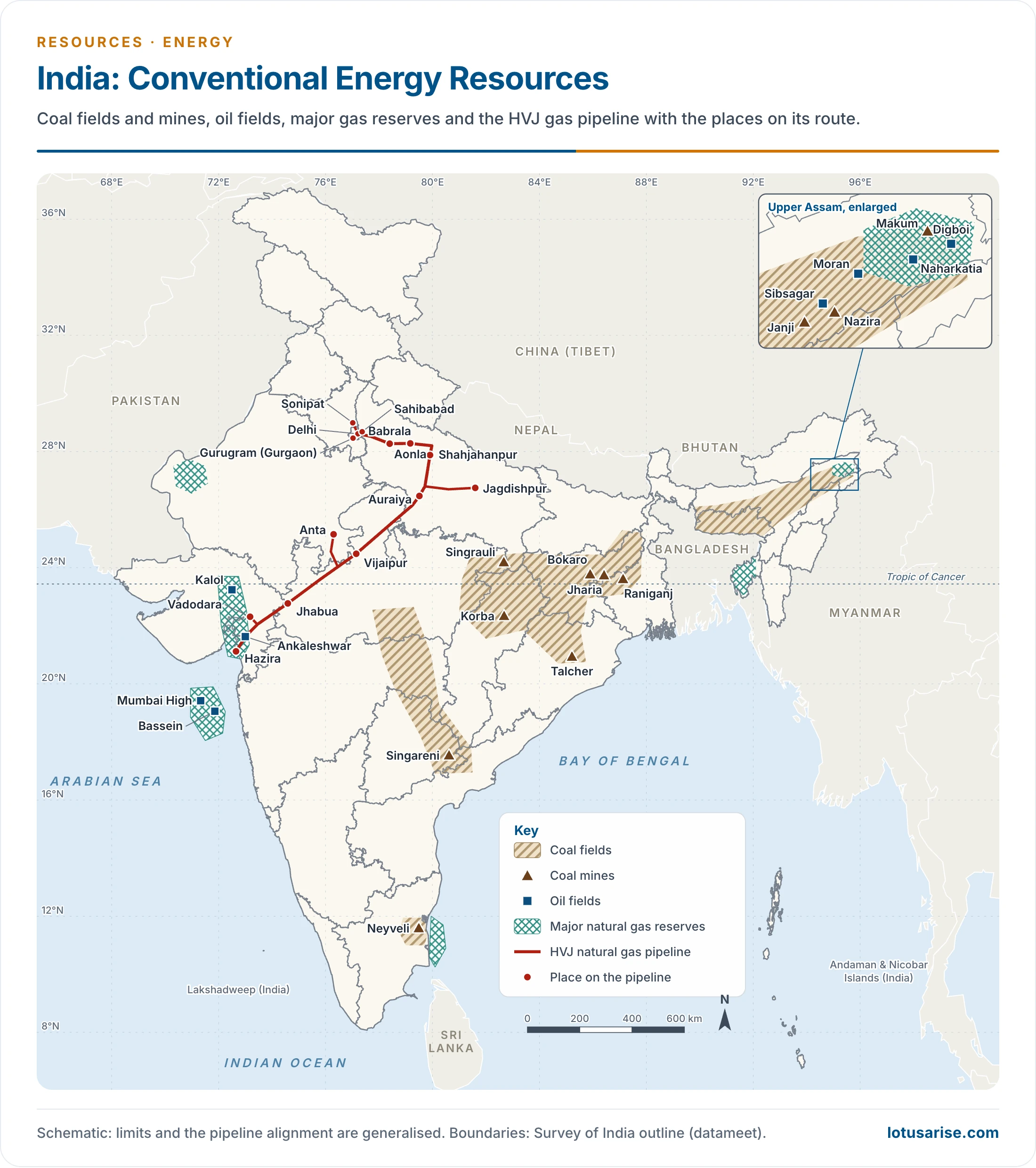
- This map predates the Barmer oilfields, so it does not show them.
Refining, Pipelines and Trade
Petroleum Refining
- Refining turns impure crude into kerosene, diesel, petrol, lubricants, bitumen and other products.
- Early refineries:
- Digboi (1901) was India’s first, and it remained the only one for over half a century.
- Mumbai came next, at Trombay: a refinery in 1954 (now HPCL) and another in 1955 (now BPCL).
- Growth in capacity: 62 million tonnes a year in 1998, 213.66 in 2014, and 267.12 million tonnes a year on 1 April 2026.
- Exports: capacity exceeds domestic demand, so surplus products go abroad. India exported 61.5 million tonnes in 2025-26, making it a refining hub.
| Company | Refineries and capacity, 1 April 2026 (million tonnes a year) |
|---|---|
| Reliance | Jamnagar 33.0; Jamnagar SEZ 35.2 |
| Indian Oil | Panipat 15.0; Paradip 15.0; Koyali 13.7; Haldia 8.0; Mathura 8.0; Barauni 6.0; Bongaigaon 2.7; Guwahati 1.2; Digboi 0.65 |
| Nayara Energy (former Essar) | Vadinar 20.0 |
| Bharat Petroleum | Kochi 15.5; Mumbai 12.0; Bina 7.8 |
| Hindustan Petroleum | Visakhapatnam 15.0; Mumbai 9.5 |
| MRPL | Mangaluru 15.0 |
| HPCL-Mittal | Bathinda 11.3 |
| Chennai Petroleum | Manali 10.5; Cauvery Basin under rebuilding |
| HPCL Rajasthan | Pachpadra 9.0 |
| Numaligarh Refinery | Numaligarh 3.0, being expanded to 9.0 |
| ONGC | Tatipaka 0.066 |
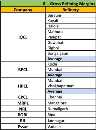
- This table was made for refining margins, and is useful here as a company list. It omits Paradip, Bathinda, Tatipaka, Pachpadra and Nagapattinam, and Vadinar now belongs to Nayara Energy.
Pipelines
- Crude reaches the nearest refinery by pipeline, and products then move to markets the same way.
- The network has grown from about 5,035 km in 1980. On 1 September 2026, it had 10,443 km of crude lines and 24,864 km of product lines. Pipelines also spread refined fuel and industry into the interior.
| Advantages | Disadvantages |
|---|---|
| Ideal for liquids and gases | Inflexible: serves only a few fixed points |
| Can cross difficult terrain and water | Capacity is fixed once laid |
| Very low energy use and little maintenance | Hard to secure |
| Safe, largely accident-free and environmentally friendly | Leaks are hard to detect and repair |
| Type | Pipelines |
|---|---|
| Crude oil | Salaya-Mathura (SMPL); Paradip-Haldia-Barauni (PHBPL), 1,465 km; Mundra-Panipat (MPPL); Naharkatiya-Nunmati-Barauni; Mumbai High-Mumbai-Ankleshwar-Koyali; Barmer-Salaya |
| Petroleum products | Guwahati-Siliguri (GSPL); Koyali-Ahmedabad (KAPL); Barauni-Kanpur (BKPL); Panipat-Delhi (PDPL); Panipat-Rewari (PRPL); Chennai-Trichy-Madurai (CTMPL); Chennai-Bangalore; Visakhapatnam-Secunderabad; Mangalore-Chennai; Vijayawada-Visakhapatnam; Mundra-Delhi |
| LPG | Jamnagar-Loni |
| Natural gas | Hazira-Vijaipur-Jagdishpur (the older “Hajira-Bijapur-Jagdishpur”, HBJ); Kochi-Mangalore-Bangalore |
- Naharkatiya-Nunmati-Barauni is India’s first pipeline, built by 1964 and 1,167 km long. It was later extended towards Kanpur.
- Salaya-Mathura carries imported crude from the Gulf of Kachchh to Koyali and Mathura, with extensions to Panipat and Jalandhar. Its first line ran 1,256 km, and Indian Oil now gives 2,663 km with branches.
- Mumbai High joins the mainland by a 210 km double line, for crude and gas.
- Jamnagar-Loni runs 1,269 km and was completed in two phases, in 2001 and 2003. It was the first cross-country LPG line.
- Chennai-Trichy-Madurai dates from June 2006, and Mundra-Delhi (1,054 km) from February 2009.
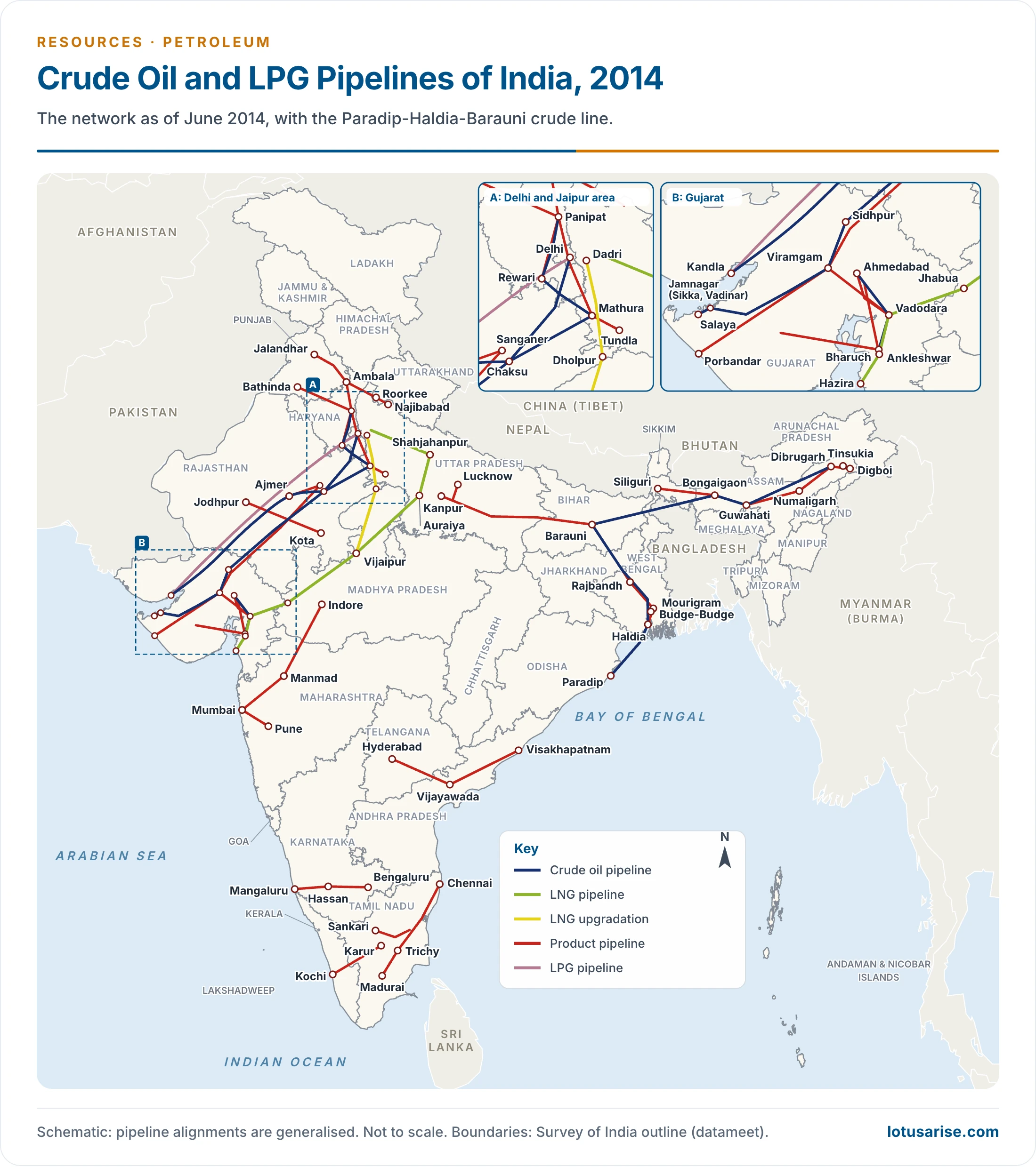
- This map shows the network as of June 2014, plus the Paradip-Haldia-Barauni crude line. Later additions are not drawn.
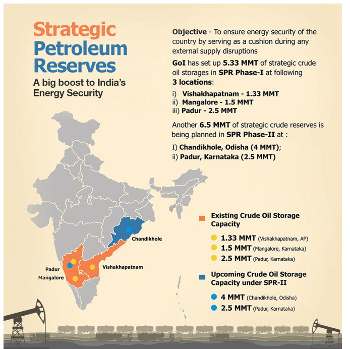
Strategic Petroleum Reserves
- Strategic petroleum reserves are large stocks of crude held against supply shocks from disasters, war or other crises.
- International rule:
- Under the International Energy Programme, each International Energy Agency (IEA) member must hold emergency stocks equal to at least 90 days of net imports.
- Members can release stocks together in a severe disruption.
- India became an associate member in 2017, not a full member.
- Origin: the idea was first proposed in the USA in 1973, after the OPEC oil crisis, a period tied to the rise of the Organisation of the Petroleum Exporting Countries.
- Why underground: caverns are the cheapest way to store crude.
- They need little surface land and reduce evaporation.
- Lying far below sea level, they can be filled easily from ships.
- Management: Indian Strategic Petroleum Reserves Limited (ISPRL) builds and runs them. It is a wholly owned subsidiary of the Oil Industry Development Board (OIDB), under the Ministry of Petroleum and Natural Gas.
| Phase | Site | Capacity (million tonnes) | Status |
|---|---|---|---|
| I | Visakhapatnam, Andhra Pradesh | 1.33 | Built |
| I | Mangaluru, Karnataka | 1.5 | Built |
| I | Padur, Karnataka | 2.5 | Built |
| II | Chandikhol, Odisha | 4.0 | Approved 2021; public-private model |
| II | Padur, Karnataka | 2.5 | Approved 2021; concession signed 1 October 2025 |
- Cover is thin: Phase I’s 5.33 million tonnes gives about 9.5 days of crude needs. Commercial stocks add much more, and total cover is put at about 74 days.
- Next steps: a parliamentary committee report of August 2026 records that sites at Bina and Bikaner are under consideration.
Imports and Geopolitics
- The gap has always existed: in 1950-51 India produced 2.7 lakh tonnes against consumption of 34 lakh tonnes.
- Crude imports: 245.3 million tonnes, costing $121.8 billion, in 2025-26, compared with 243.2 million tonnes and $137.2 billion in 2024-25.
- Share of the import bill:
- Under 9% in the 1960s, about 30% after the 1973-74 oil crisis, and about 75% in the 1980s after the second crisis.
- 31.7% in 2011-12, and 18.4% in 2025-26, when prices fell.
- Changing sources: the Gulf long dominated, as the 2013 chart shows.
- Russia became a major supplier, and its monthly share has swung widely, from 19.3% in January 2026 to above 40% by mid-2026.
- Iraq led in February 2026.
- The 2026 shock: conflict in West Asia disrupted the Strait of Hormuz. Earlier estimates put roughly 40% of India’s crude on this route. The Petroleum Minister told Parliament on 12 March 2026 that it was about 45% before the crisis, and that refiners had raised supplies from outside the strait to about 70%, turning to Russia, Africa and Latin America.
- Wider stakes: oil remains central to energy security and the energy transition.
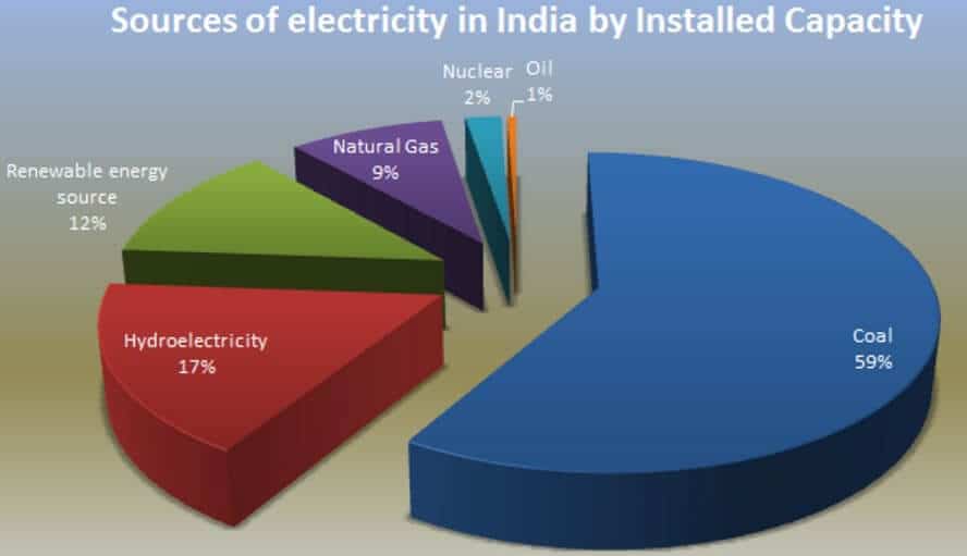
- This chart is older. On 31 March 2026, installed capacity was coal 41.7%, lignite 1.2%, renewables other than large hydro 41.9%, hydro 9.7%, gas 3.8%, nuclear 1.6% and diesel 0.1%.
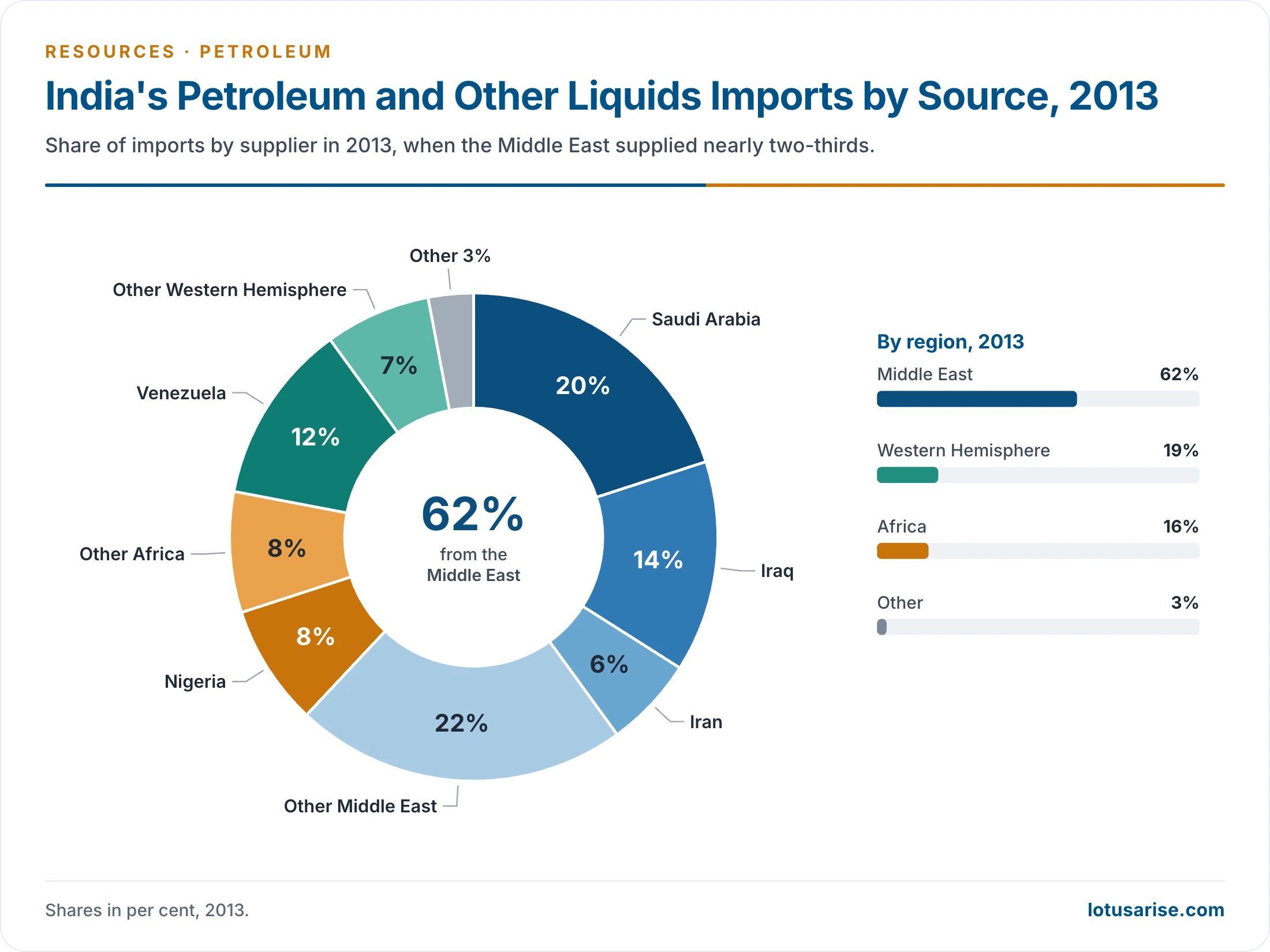
- This chart shows 2013 only. Russia, not named on it, has since become a leading supplier.
Conservation of Petroleum Products
- Transport has been the largest user, at about half of petroleum use, and road transport alone at about 37%.
- Efficient engines, better roads and smoother traffic can save 30–35% of fuel.
- A diesel locomotive is 7–8 times as efficient as a diesel truck, so long-haul freight should shift to rail, as the Dedicated Freight Corridors intend.
- Stronger public transport cuts private fuel use.
- Industry took about 16–20%. Better energy management has already shown savings in steel, petrochemicals, cement and paper.
- Agriculture can save high-speed and light diesel through pump rectification, efficient foot valves and better machinery.
- Fertiliser plants should move from liquid fuels to gas or coal.
- Households: kerosene and LPG are hard to replace, so efficient use matters.
- Petroleum Conservation Research Association (1978) runs awareness campaigns, and works with the Bureau of Energy Efficiency on labelling standards.
- Ethanol blending in petrol reached 20% by March 2026.
Previous Year Questions
2026Describe the role of energy pipelines in the industrial development and in reducing the regional imbalances in India.2025Why is oil important for energy security? What is the role of oil in clean energy transition?2024Map item: Tatipaka2023Critically examine the role of petroleum energy resources in international geopolitics with special reference to India.2018Explain the pipeline network across India and its impact on regional development.2010Write about the Offshore oilfields and coastal ecology.2002Discuss the oil and natural gas pipeline networks in India. Highlight their complementary role in regional development.1995Examine the fossil fuel resources of India with particular reference to the present and future demands for energy.1990Assess the fossil fuel reserves of India in terms of current and future demands for energy. Examine the present and future and prospects of their utilization.





Very Very helpful notes , as in last mains my notes are not organized and not that of good quality, i didn’t qualify mains. But sir in this time , surely your quality notes will help me to get a very good marks. Also it saves my efforts and time to get quality content. Thanks you so much sir .
Thanks, Samrat for your kind words.
did you got good marks
thanks very helpful
Thanks Sir…for such Excellent crispy notes!
Crisp & handy at the same time.