

- Rural settlement type is the degree of nucleation or dispersion of houses and villages over the rural landscape of villages, fields and pastures.
- It measures both social gregariousness and the geo-climatic conditions and land capability of an area. As a rule, the higher the land capability, the greater the nucleation.
- Type is distinct from pattern. Type asks how far dwellings are gathered at one site; pattern asks what geometric shape they make (linear, rectangular, circular and so on).
Identifying Settlement Types

Schemes of Classification
- Geographers have grouped rural settlements into two, three or four types:
| Scheme | Types |
|---|---|
| Vernor C. Finch and Glenn T. Trewartha | Isolated (dispersed) and nucleated |
| D.C. Money | Single large nucleated village; hamlets scattered over the countryside; single homesteads |
| Enayat Ahmad | Compact; cluster and hamlet; fragmented or hamleted; dispersed |
| Ram Lochan Singh | Compact; semi-compact (hamleted cluster); semi-sprinkled (fragmented, hamleted); sprinkled (dispersed) |
| R.B. Singh | Compact; semi-compact; hamleted; dispersed (by the ratio of villages to hamlets) |
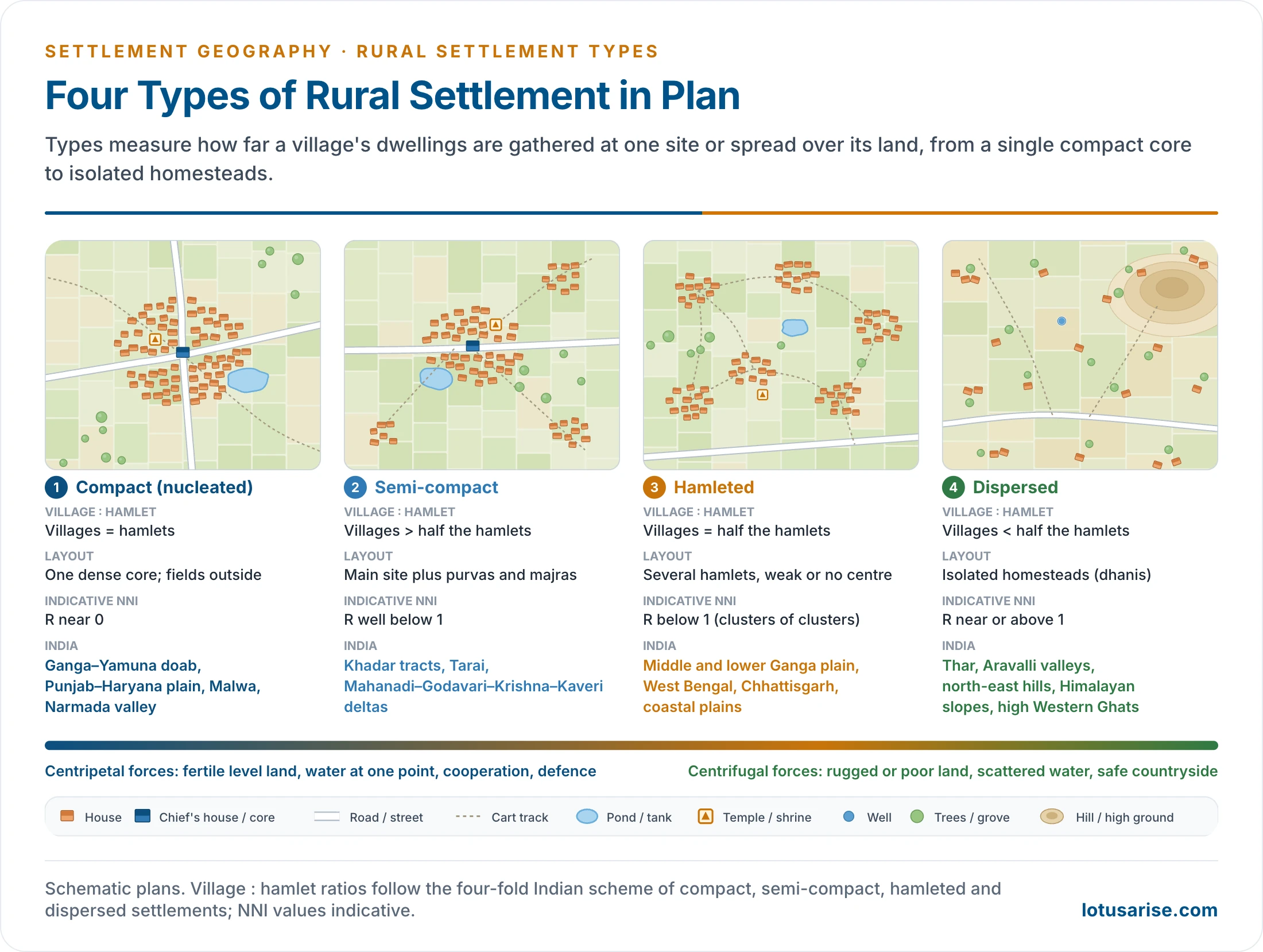
- The four-fold scheme of compact, semi-compact, hamleted and dispersed settlements is the standard frame for India. Many texts merge the middle two as “semi-nucleated”.
Measuring Nucleation
- Types are first read from topographical sheets (1:50,000), satellite images and village maps.
- They are then measured with statistical indices, which give an objective value of dispersion, concentration and shape: the nearest-neighbour index, Demangeon’s coefficient, the village–hamlet ratio, indices of concentration and shape indices.
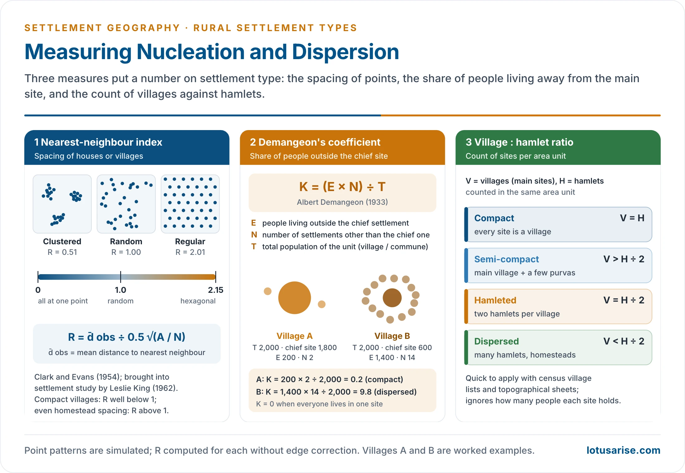
- Nearest-neighbour index (R):
- Developed by Philip Clark and Francis Evans (1954), ecologists studying plant spacing. Leslie King (1962) applied it to the spacing of settlements.
- It compares the observed mean distance from each house or village to its nearest neighbour with the mean distance expected if the same number of points were scattered at random over the same area.
- R = d̄ obs ÷ 0.5√(A/N), where A is the area and N the number of points.
- R = 0: all points at one place, the most compact type.
- R = 1: a random spread.
- R ≈ 2.15: a perfectly even hexagonal spacing.
- Compact villages give values well below 1 when houses are the points. Evenly spaced homesteads give values above 1.
- The same formula is also written Rn = 2d√(n/A).
- Indicative reading by type: compact near 0, semi-compact well below 1, hamleted below 1, dispersed near or above 1.
- Bands sometimes quoted for villages (0 to 1.5 less nucleated, 1.5 to 2.5 semi-nucleated, above 2.5 dispersed) cannot be read literally: the index tops out near 2.15, and a value above 1 means regular spacing, not dispersal.
- Coefficient of dispersion (Albert Demangeon, 1933):
- K = (E × N) ÷ T
- E = population living outside the chief settlement (in hamlets and homesteads);
- N = number of settlements other than the chief one;
- T = total population of the unit (the village or commune).
- K = 0 when everyone lives at the main site. K rises with dispersion, because both the share of people outside the main site and the number of outlying sites grow.
- Example:
- Village A has 2,000 people, 1,800 at the main site and two small hamlets: K = 200 × 2 ÷ 2,000 = 0.2 (compact).
- Village B has 2,000 people, 600 at the main site and 1,400 in 14 hamlets: K = 1,400 × 14 ÷ 2,000 = 9.8 (dispersed).
- Demangeon devised it for the rural habitat maps of France. It needs only census population by site, but it ignores distance and spacing.
- K = (E × N) ÷ T
- Village–hamlet ratio (R.B. Singh): the number of villages (V) compared with the number of hamlets (H) in an area unit.
- Compact: V = H, so every site is a main village.
- Semi-compact: V is more than half of H.
- Hamleted: V is equal to half of H.
- Dispersed: V is less than half of H.
- Other indices:
- The index of concentration measures how far a region’s rural population is held in one or a few large settlements rather than many small ones.
- It reads the dominance of the chief settlement in the system, and so is a measure of spatial inequality among settlements.
- A high value means strong concentration and compact settlement; a low value means dispersion. This runs opposite to Demangeon’s coefficient, where a higher value means more dispersion.
- Shape indices compare the outline of a village with a circle.
- The index of concentration measures how far a region’s rural population is held in one or a few large settlements rather than many small ones.
The Four Types
Compact (Nucleated) Settlements
- Compact settlements are concentrated, fused and closely packed, with little or no open space between houses.
- A community feature such as a temple, mosque, pond, well or the headman’s house forms the nucleus, and the village grows outward from it.
- All dwellings stand on one central site, and the fields lie outside the built-up area.
- Size ranges from about thirty houses to several hundred. Villages have 500–2,500 people in sparsely peopled Rajasthan and more than 10,000 in parts of the Ganga plain.
- Houses of one caste group usually share a quarter, so caste segregation is marked. Markets, shops and shrines cluster at the densely built centre.
- Determinants of nucleation:
- Site: flood-free, fertile ground, such as the bhangar (older alluvium) of the northern plain, river levees, and the rims of ox-bow lakes in the middle Ganga plain.
- High land capability: to use rich land fully, a large population settles at one point, leaving every field for cultivation.
- Hydrology:
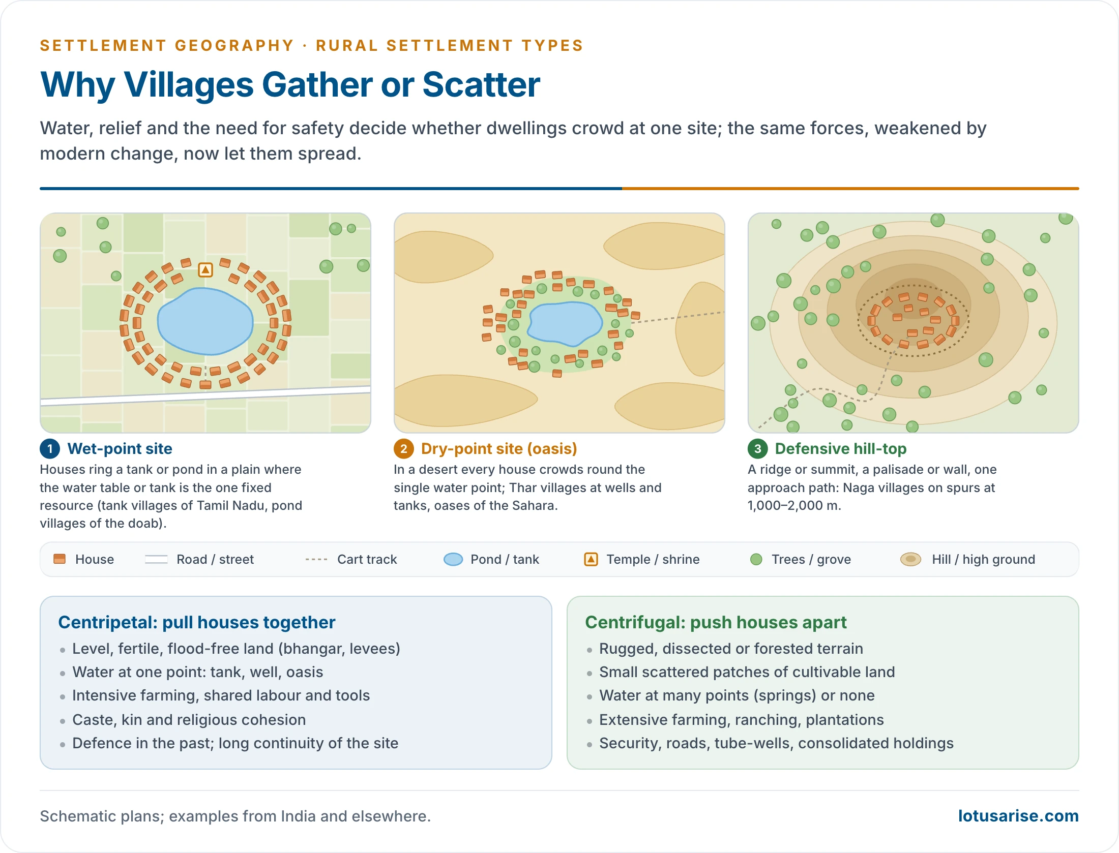
- Wet-point settlements gather round a well, pond, tank or lake, as in the tank villages of the peninsula.
- Dry-point settlements crowd round the only water point in a dry area: an oasis in the Sahara or a well or tank in the Thar.
- Defence: living close together behind a common boundary protects against raiders and wild animals.
- Villages in the forests and valleys of the Shiwaliks, western, central and eastern India, Rajasthan, Punjab and Bundelkhand grew compact for security in unstable times.
- Some tribal communities fence their settlements against wild animals.
- Naga villages sit on hill-tops and ridges at about 1,000–2,000 m, once for protection against head-hunting raids.
- Cooperation: intensive farming, tilling, irrigation and the sharing of implements and labour bring farming families together.
- Uniform relief brings similar ways of life and a sense of brotherhood, strengthened by bonds of class and kinship.
- Historical continuity: a long-occupied site gathers more households over generations.
- Social cohesion: people of the same caste, clan, religion or ethnic group prefer to live together and follow shared customs.
- In towns the same force makes ethnic quarters, such as Chinatown in Kolkata.
- Distribution:
- World: productive alluvial plains and river valleys, the most widespread rural type.
- Examples are the North China Plain and the Huang He valley, the Nile valley and delta of Egypt, the Indo-Gangetic plain of India and Pakistan, Bangladesh, the cultivated tracts of eastern China, Mexico, the North European Plain and parts of Kenya.
- Fishing and hunting communities need shared effort in building and handling boats and nets. Examples are fishing villages along the Brahmaputra and Hooghly, and Native American villages.
- Scarce resources: where water or good land is scanty, compactness makes the most of it, as at oases in the Sahara and Rajasthan.
- India:
- Punjab, Haryana, western Uttar Pradesh and the Ganga–Yamuna doab: large, evenly spaced compact villages.
- Malwa plateau, the Narmada valley and the Nimar upland.
- The Deccan lava plateau, where villages gather near water.
- The Vindhyan plateau and the paddy lands of Bihar and Uttar Pradesh.
- The raised deltas of the Krishna, Godavari and Kaveri.
- Planned canal-colony villages of Ferozepur in Punjab and Ganganagar in Rajasthan.
- The purvas and majras of the Ganga plain also show how intensive cultivation keeps settlement compact.
- World: productive alluvial plains and river valleys, the most widespread rural type.
Semi-compact Settlements
- A semi-compact settlement has one early, easily recognised main site with one or more small hamlets at its edge.
- The hamlets are linked to the main village by footpaths, cart tracks or roads.
- The dwellings are less closely knit, and the settlement covers more ground than a compact one.
- The hamlets (purvas, majras, nanglas) grow as the main site fills up. Landless labourers, artisan castes and poorer households move out first but stay close, because of social links and economic dependence on the main village.
- Causes:
- Population pressure on the main site.
- Physical breaks such as streams, ravines, flood channels and uneven ground.
- Caste segregation, as groups keep both proximity and social distance.
- Fragmentation of holdings, which makes it convenient to live nearer distant fields.
- Poor land capability: large areas must be worked to support small groups, so people spread out to save travel, time and energy.
- It is often a transitional stage: dispersed settlements become semi-compact as population grows and new technology spreads, and compact villages become semi-compact as they overflow.
- Regions:
- The khadar (new alluvium) of the Ganga, Yamuna, Brahmaputra and their tributaries, and the bet lands of Punjab.
- The Tarai of Uttar Pradesh and Uttarakhand.
- The deltas of the Mahanadi, Godavari, Krishna and Kaveri.
- The Gujarat plain and parts of Rajasthan east of the Aravallis.
- The plateau tracts of Malwa, Bundelkhand, Telangana and the drier Deccan.
- Hilly tracts of Madhya Pradesh, Arunachal Pradesh, Meghalaya, Manipur, Mizoram and Tripura, and the Brahmaputra valley.
Hamleted (Fragmented) Settlements
- The settlement is split into several physically separate hamlets of similar size, scattered over the village land with fields between them.
- The main site is absent or has little pull over the others, and the original site is often hard to identify.
- The hamlets share one name and one revenue boundary, but each has its own name, such as a tola in Bihar or a para in Bengal.
- Causes:
- Social segregation by caste, as each caste or clan builds its own tola.
- Floods and swampy or uneven ground that leave only scattered dry sites.
- Clearing of forest by separate groups.
- Regions:
- The middle and lower Ganga plain (eastern Uttar Pradesh, Bihar, West Bengal).
- The Chhattisgarh plain, Madhya Pradesh and the coastal plains.
- The lower Himalayan valleys.
Dispersed (Scattered) Settlements
- In dispersed settlements isolated houses or farmsteads are spread over a wide area, usually standing on their own fields.
- The number of houses per unit area is very low, with wide gaps between them.
- A dispersed village usually has 2–5 or up to 10 huts in each cluster; true isolated single homesteads are rare in India.
- Causes:
- Poor land capability and poor hydrology. Small, scattered patches of cultivable land and water at many points (springs) or none.
- Rugged, dissected or forested terrain, and natural hazards such as floods.
- Extensive farming, ranching and plantations, where farmers must live on their land rather than in a distant village.
- Security under settled government, so defensive clustering is no longer needed.
- Individualism and the wish to live freely.
- Age: many dispersed settlements are recent.
- People move out of crowded villages in search of land, and new technology (tube-wells, roads, electricity) makes isolated living possible, even in deserts.
- Land consolidation and tube-wells have taken many farmhouses out into the fields in the wheat and sugarcane belt of Punjab, Haryana and western Uttar Pradesh.
- When people take up marshy land, khadar tracts or marginal uplands, they need large areas for a living and settle on isolated farms.
- Some dispersed settlements occur even on good land, for historical or social reasons. An overflow group may found a scattered new settlement between two large compact villages in the northern plain.
- World:
- The farmsteads of the Prairies (USA, Canada), the Pampas (Argentina) and the Downs (Australia).
- The steppe east of the Urals in Kazakhstan and Russia, colonised from the late 19th century.
- Thinly peopled northern Canada, central Australia, Scandinavia and the western USA.
- India:
- Himalayan slopes of Jammu and Kashmir, Himachal Pradesh, Uttarakhand and Sikkim, and Leh–Ladakh.
- The forested hills of the north-east (Meghalaya, Mizoram, Manipur, Arunachal Pradesh, Tripura) and the Shiwaliks.
- The Thar (Barmer, Jaisalmer, Bikaner) and Kachchh, where isolated dhanis dot the sand.
- The Aravalli valleys of Mewar, Alwar and Udaipur.
- Flood-prone tracts of Uttar Pradesh and Bihar, the western Malwa plateau, the rims of small water bodies in West Bengal and the hilly parts of Odisha.
- The higher Western Ghats from Satara to Keralam (Kerala), their rain-shadow tract, and tribal tracts of central India such as Bastar.
- In Keralam, houses stand dispersed in homestead gardens along roads, yet each census village is very large.
| Feature | Compact settlements | Dispersed settlements |
|---|---|---|
| Typical land | Fertile plains, river valleys | Hills, plateaus, forests, arid tracts |
| Main occupation | Intensive agriculture | Grazing, lumbering, extensive farming |
| Houses | Close together, small living space | Isolated, more living space |
| Fields | Small, fragmented, outside the village | Large, round the house |
| Sanitation | Lanes crowded, poor drainage | Cleaner surroundings |
| Social life | Collective work and defence | Isolated living |
Factors Influencing Types
- Physical factors:
- Relief: level plains favour compact villages, while dissected hills and plateaus scatter them.
- Water: a single water point concentrates people; abundant or widely spread water lets them spread.
- Soil and land capability: rich soils support dense, compact villages; poor soils need large holdings and scattered farmsteads.
- Climate and hazards: flood-prone khadar and deltaic land breaks settlements into raised fragments; severe cold or aridity leaves isolated homesteads.
- Economic factors:
- Intensive subsistence farming favours compact villages.
- Extensive farming, ranching, shifting cultivation and plantations favour dispersion.
- Kuki cultivators of Manipur build temporary huts in their jhum fields.
- Social factors: caste and clan segregation produces hamlets; shared religion and kinship hold villages together.
- Historical factors: past insecurity produced defensive nucleation, and long continuity of a site adds to it. Planned colonisation (canal colonies, resettlement villages) imposes compact or grid forms.
- Modern change: roads, rural electrification, tube-wells, consolidation of holdings and law and order loosen compact villages, so new houses spread along roads and into the fields.
- In short, centripetal forces (water at one point, fertile level land, cooperation, defence) gather houses, while centrifugal forces (rugged or poor land, scattered resources, security) spread them.
Types in India: Regional Pattern
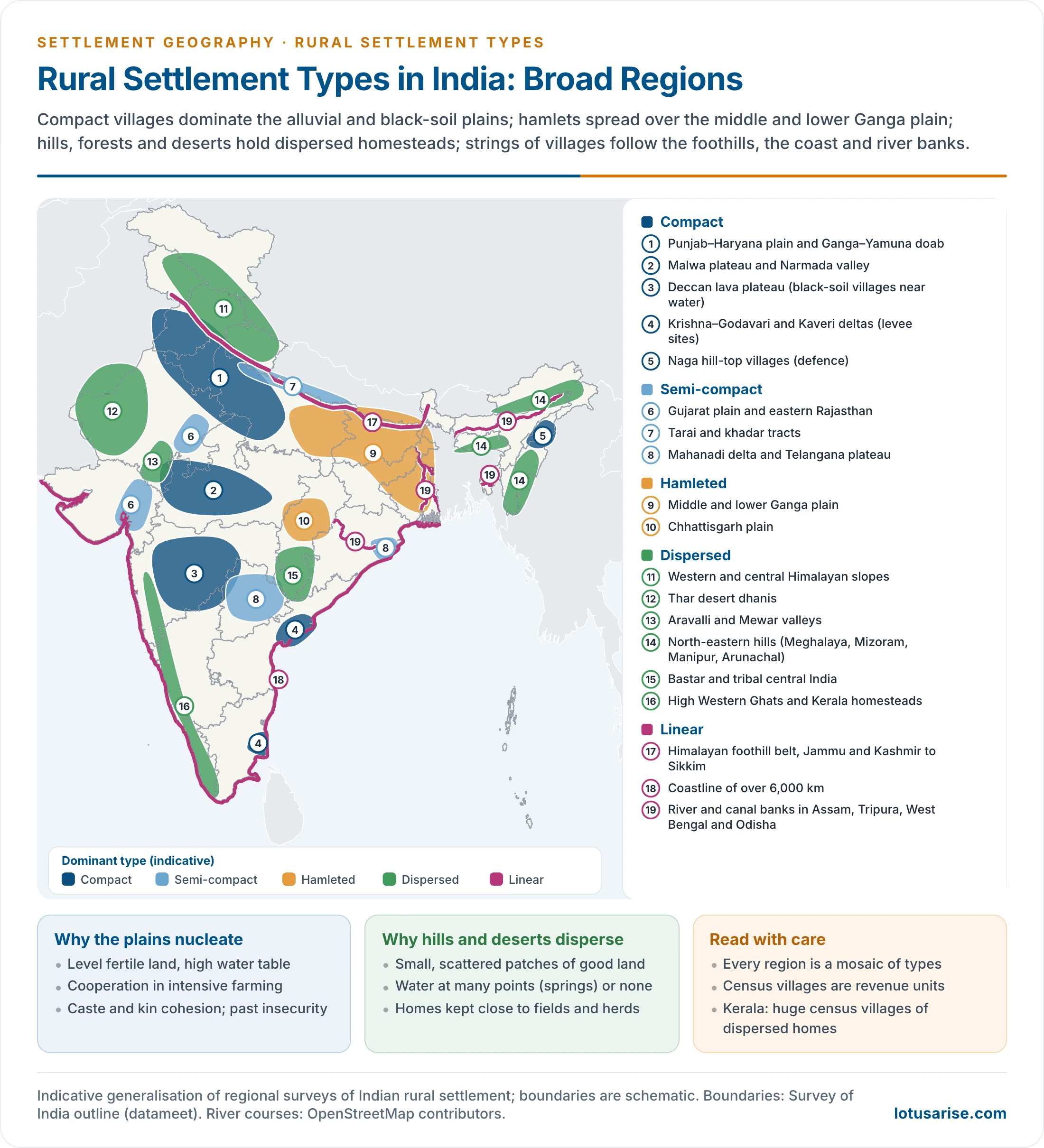
- For an all-India view, rural settlements are often sorted into three broad zones:
- Nucleated: most of India, above all the northern plain (Punjab, Haryana, Uttar Pradesh, Bihar, West Bengal) and the Brahmaputra valley.
- Dispersed: the Himalayan ridges and spurs, north-eastern forests, the Thar, the higher Western Ghats and other broken or flood-prone tracts.
- Linear: the Himalayan foothill belt from Jammu and Kashmir to Sikkim, the coastline of over 6,000 km, and river and canal banks in Assam, Tripura, West Bengal and Odisha. The patterns give the detail.
- Himalayas:
- Inter-montane valleys such as Kashmir, Kullu and the Dun have compact or semi-compact villages.
- Higher slopes have dispersed homesteads, because of cold, steep relief and scarce farmland.
- Transhumant groups such as the Gujjars and Bakarwals of Kashmir the Bhotias of Himachal Pradesh and Uttarakhand and the Lepchas of Sikkim keep permanent winter homes in the valleys and temporary summer huts on alpine pastures.
- North-east:
- Small, widely dispersed settlements reflect rugged terrain, heavy rain, dense forest and many tribes.
- Hill-top villages are common in Nagaland, linear villages along ridges and roads in Mizoram, and homesteads to semi-compact villages on the Khasi and Jaintia hills.
- In the Brahmaputra valley, small villages line the levees, with houses raised on stilts (machan) against floods.
- Northern plain:
- Punjab, Haryana and western Uttar Pradesh have large, compact, evenly spaced villages on the bhangar.
- The khadar and bet lands, flooded almost every year, have semi-compact or scattered settlements.
- The middle Ganga plain has small, closely spaced semi-compact and hamleted settlements.
- The lower Ganga plain varies with drainage; scattered settlements are common in the Duars and the Sundarbans.
- Rajasthan:
- East of the Aravallis (around Jaipur) villages are compact or semi-compact.
- West of the Aravallis (Jaisalmer, Barmer), dunes and scarce water give large villages far apart (about 10 km apart in Jaisalmer) with dhanis between them.
- Peninsula:
- Malwa has large compact villages of 500–5,000 people; Sehore, Indore and Betul have some of 5,000–10,000.
- Chhattisgarh has small villages; about two-thirds have fewer than 500 people.
- Chota Nagpur has clustered and semi-clustered villages; Baghelkhand has compact ones.
- Bundelkhand has larger nucleated villages, mostly near towns.
- In Mayurbhanj, Kendujhar and Sundargarh (Odisha) and the Mahanadi basin, nucleated villages stand on the valley slopes.
- The black-soil plateau of Maharashtra has compact villages near water, but the tract between Pune and Solapur is semi-compact and dispersed.
- The Karnataka Maidan has widely spaced compact villages, and the Malnad hills semi-compact ones.
- Malnad villages are small, on poor soil under teak, sal and sandal forest. The northern Karnataka plain has villages of 2,000–10,000 people.
- Coastal Andhra and Rayalaseema are compact, and Telangana compact to semi-compact.
- The crest of the Sahyadri, from the Tapi to Kanniyakumari, is dotted with isolated houses.
- Coasts:
- East coast deltas have compact villages on raised levees.
- Kachchh has small semi-compact and scattered settlements, and the Konkan compact and semi-compact ones.
- The Malabar coast has very large villages of dispersed homesteads amid coconut and cashew gardens.
- Fishing villages line the whole coastline.
- Spacing and size:
- Villages are less than 2 km apart in the Ganga plain but up to 5 km in the hills.
- High spacing with low density marks the mountains; low spacing with high density marks the plains.
- The density of villages in 2011 was highest in Bihar (about 48 per 100 km²) and lowest in Jammu and Kashmir and Keralam (about 3). India averaged 19.
- High: Bihar (48), Uttar Pradesh and West Bengal (45), Jharkhand (41), then Himachal Pradesh (37), Assam (34), Odisha (33) and Uttarakhand (31).
- Low, at 10 or below: Jammu and Kashmir and Keralam (3), Mizoram (4), Sikkim (6), Arunachal Pradesh (7), Tripura (8), Nagaland, Gujarat and Goa (9), undivided Andhra Pradesh (10).
- Among Union Territories, Lakshadweep is highest (65) and Chandigarh lowest (4).
- Number of villages (Census 2011): about 6.4 lakh, with 597,608 inhabited.
- Uttar Pradesh has the most (106,704, about 16.6%). Madhya Pradesh and Odisha have over 50,000 each.
- Keralam has only 1,018, but they are very large. Goa has the fewest of any State (334). Among Union Territories, Chandigarh has 5 and Andaman and Nicobar 555.
- Size of villages (Census 2011): the commonest slab is 500–999 people, about a quarter of all inhabited villages, and numbers fall away on both sides.
| Population | Inhabited villages | Share (%) |
|---|---|---|
| 10,000 and above | 4,681 | 0.8 |
| 5,000–9,999 | about 18,640 | 3.1 |
| 2,000–4,999 | about 96,390 | 16.1 |
| 1,000–1,999 | about 139,130 | 23.3 |
| 500–999 | about 141,760 | 23.7 |
| 200–499 | about 114,730 | 19.2 |
| Under 200 | 82,151 | 13.7 |
- Hill areas have small villages, most under 1,000 people. Sikkim, Arunachal Pradesh, Mizoram, Meghalaya, Daman and Diu, Lakshadweep and Andaman and Nicobar have none above 10,000; Himachal Pradesh, Nagaland, Dadra and Nagar Haveli and Goa have one each.
- Keralam is the exception: 797 of its 1,017 inhabited villages (78%) exceed 10,000 people, and they hold 92% of its rural population. Nationally such villages hold under 9%.
- Bihar has the most villages of this size (1,129).
Forms and Names of Rural Settlements
- By size of the cluster:
- Farmstead: two or three houses on the farm. Typical of extensive agriculture: the Prairies, Downs and temperate grasslands.
- Hamlet: a small cluster of 7 to 9 houses, signifying poor land capability and low density. Found in Rajasthan, and in Britain and Scotland.
- Village: a larger cluster of more than 10 houses.
- By local name: the place names of the northern plain carry the history and status of a settlement.
| Name | Meaning |
|---|---|
| Pura | An old habitation site that became the nucleus of nearby settlements; shows long continuity |
| Khas (sadar) | The main or parent village, often a medieval revenue centre, from which others grew |
| Kalan | Suffix for a large village of many castes and classes (Bound Kalan) |
| Khurd | Suffix for a small village, from the word for “small” or “young” (Dumarkha Khurd) |
| Khera | Small colony or the high ground of a village; site of fairs, Ramlila and Nautanki, and sometimes of old fort ruins |
| Nangla | A group of small villages, with one village ringed by satellite hamlets |
- Types are not static.
- Changes in occupation, farming systems, technology and social structure rework them: hamlets fuse into villages as population grows, and compact villages loosen as roads and tube-wells pull houses outward.
- These changes also reshape the internal morphology of rural settlements and their caste-based social morphology.
Previous Year Questions
1992Citing suitable examples from India, explain the role of site and other physical factors in determining the types and patterns of rural settlements.2005Discuss briefly the principle types of rural settlements in India.2012Give an account of geographical conditions responsible for the development of different types of rural settlements in India.2016Discuss the role of site in determining the types and patterns of rural settlements.2016Present a comparative analysis of geographical factors responsible for distribution of human settlements in the Rajasthan desert and North-Eastern regions of India.2023“Rural settlements are expressions of the basic relationships between human beings and their physical and social environment.” Discuss.2025“The rural settlements in India are highly diversified due to both physical and cultural factors.” Justify the statement with examples.





Excellent notes for geography optional….thank you sir
Forever grateful for your selfless service. 🙏🏻
So kind of you, thanks and Keep Reading
thank you sir for these notes, really grateful to you. sir, i think definition of dry point settlements is not correct , as they tend to nucleate around drier areas in wetlands to avoid flooding.
wet point settlement – these are sites close to a supply of water.
dry point settlement – these are sites for avoiding the risk of flooding.
Hamen sare notes Hindi mein chahie