

- A monsoon is a seasonal reversal of the prevailing wind, bringing moist, onshore air and heavy rain in summer and dry, offshore air in winter. The word comes from the Arabic mausim (“season”), used by Arab sailors for the winds of the Arabian Sea that blow from the south-west for about six months and from the north-east for the rest of the year.
- The ideal monsoon is that of South and South-East Asia, where the wind turns through almost 180°; the Indian monsoon supplies about three-quarters of India’s annual rainfall (June–September normal: 868.6 mm).
- No single cause explains it. Explanations have moved from land–sea heating (thermal) to the seasonal shift of planetary belts and the ITCZ (dynamic), then to the upper air (jet streams, Tibetan Plateau) and ocean–atmosphere teleconnections (ENSO, IOD, MJO). Today the monsoon is seen as one regional face of a global monsoon tied to the annual migration of the tropical rain belt.
Defining the Monsoon

Criteria and the Global Monsoon
- Wind-based definition: Colin Ramage (1971). A region is monsoonal if:
- the prevailing wind shifts by at least 120° between January and July
- the prevailing direction is steady, occurring at least 40% of the time in each month
- the mean wind exceeds 3 m/s in at least one of the months
- fewer than one cyclone–anticyclone alternation occurs every two years in either month
- Only parts of Asia, Africa and northern Australia qualify, roughly between 35°N and 25°S and from 30°W to 170°E.
- Rain-based definition: Bin Wang and Qinghua Ding (2008). The global monsoon domain is where the local-summer minus local-winter rainfall is large (the IPCC (2021) uses more than 2.5 mm/day) and most of the year’s rain falls in summer. This brings the American monsoons into the family.
- The IPCC Sixth Assessment Report (2021) recognises six regional monsoons: South and South-East Asian, East Asian, West African, North American, South American and Australian–Maritime Continent. All are linked to the seasonal swing of the ITCZ and the Hadley circulation.
| Monsoon | Summer flow | Winter flow | Distinctive feature |
|---|---|---|---|
| South Asian | South-west, cross-equatorial | North-east, dry | Strongest; Himalaya–Tibet barrier and heat source |
| East Asian | Southerly to south-westerly; Meiyu–Baiu front | Cold north-westerly from Siberian High | Strong, cold winter monsoon |
| West African | South-westerly from Gulf of Guinea | Dry north-easterly Harmattan | Sahel rainfall highly variable |
| Australian | North-westerly | South-east trades | Northern Australia only |
| North American | Gulf of California moisture | Westerly, dry | Mexico, Arizona; weak wind reversal |
Pseudo-Monsoon
- A pseudo-monsoon (monsoon tendency) is a region with some seasonal reversal or summer rain peak caused by unequal heating of land and sea, but without the full monsoon: the reversal is partial, the summer flow shallow and short, and summer rain is not dominant. Typical areas:
- West Africa (Guinea coast) and East Africa with Madagascar
- Northern Australia
- Eastern and south-eastern USA, with summer southerlies from the Gulf of Mexico
- Western and central Europe, where cool, moist westerlies return in early summer (the “European monsoon”)
- Why weaker than Asia: smaller or narrower land masses, no high plateau acting as an elevated heat source, no east–west mountain wall to block polar air, cold currents offshore, and desert or ocean on the poleward side.
- Evaluation: the label is a classical, wind-based one. By the rain-based definition, the West African, Australian and North American systems are true monsoons; the IPCC treats them as such and keeps no pseudo-monsoon class.
Classical Theories
Thermal Concept: Edmond Halley (1686)
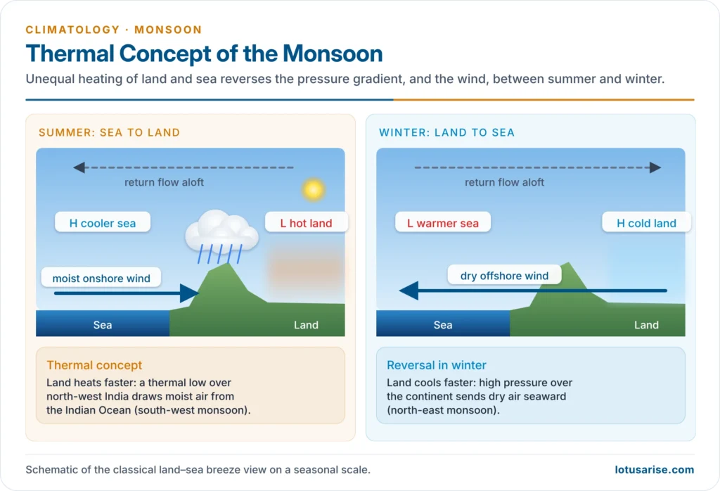
- Proponent: Edmond Halley (1686), supported later by Julius Hann and others, who saw the monsoon as a land and sea breeze on a seasonal scale.
- Assumption: land heats and cools faster than sea, so pressure over land swings more between seasons.
- Summer: Asia heats strongly and develops a thermal low (over north-west India and Pakistan); the cooler Indian Ocean holds high pressure (the Mascarene High). Moist air flows from sea to land, the south-east trades cross the equator, turn right by Ferrel’s law, and arrive as the south-west monsoon.
- Winter: the cold continent carries high pressure; dry air flows from land to sea as the north-east monsoon, which rains only where it crosses water (Tamil Nadu, eastern Philippines, western Japan).
- Criticism:
- The thermal low over north-west India is shallow (below about 700 hPa) and the winter high too shallow to reverse the wind.
- It cannot explain the sudden burst, the breaks, or the year-to-year swings in rainfall.
- Land is hottest in May, yet the monsoon sets in during June; the hottest area, the Thar, is among the driest.
- Onshore winds alone do not make rain: rain needs uplift by mountains, monsoon depressions and convergence. During the strongest monsoon flow, rain is often scarce away from mountain slopes.
- Current view: land–sea heating contrast remains a necessary condition, but heating of the whole troposphere over land and the moist energy of the air matter more than surface temperature alone.
Air-Mass (ITCZ) Theory
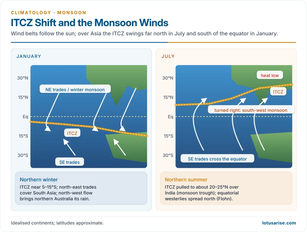
- The monsoon is explained by the seasonal migration of the Inter-Tropical Convergence Zone and the air masses on either side of it.
- Summer: the ITCZ moves to about 20–25°N over India as the monsoon trough, drawing equatorial maritime air from the southern hemisphere across the equator. Rain falls along the convergence and in the disturbances it spawns.
- Winter: the ITCZ moves south of the equator; India comes under dry continental air and the north-east trades.
- Criticism: the monsoon trough is a thermal trough, not a classic meeting of two trade systems, and the theory does not explain the abrupt onset or the upper-air reversal.
Dynamic Concept: Hermann Flohn (1951)
- Hermann Flohn (1951) held that the monsoon is simply the normal seasonal migration of the planetary wind and pressure belts following the overhead sun, magnified over continents.
- The mean axis of the equatorial westerlies lies near 10°N in July and 5°S in January.
- Regions between two belts fall under opposite regimes in the two seasons.
- Summer monsoon = the equatorial westerlies displaced north, not a prolonged south-east trade.
- Winter monsoon = the north-east trades re-established, not an outflow from a thermal high.
- Continental versus oceanic tropics: over land, the annual temperature range is large and the belts shift by many degrees (Africa, India–Australia); over the open Pacific they shift only a little, so no monsoon forms there.
- Criticism: it neglects the upper-air circulation and the role of the Tibetan Plateau, which Flohn himself later stressed, and the “equatorial westerlies” over India are deeper and stronger than a simple shift would give. It remains the framework that the global-monsoon view builds on.
Upper-Air Theories
Jet Stream Theory: Maung Tun Yin (1949)
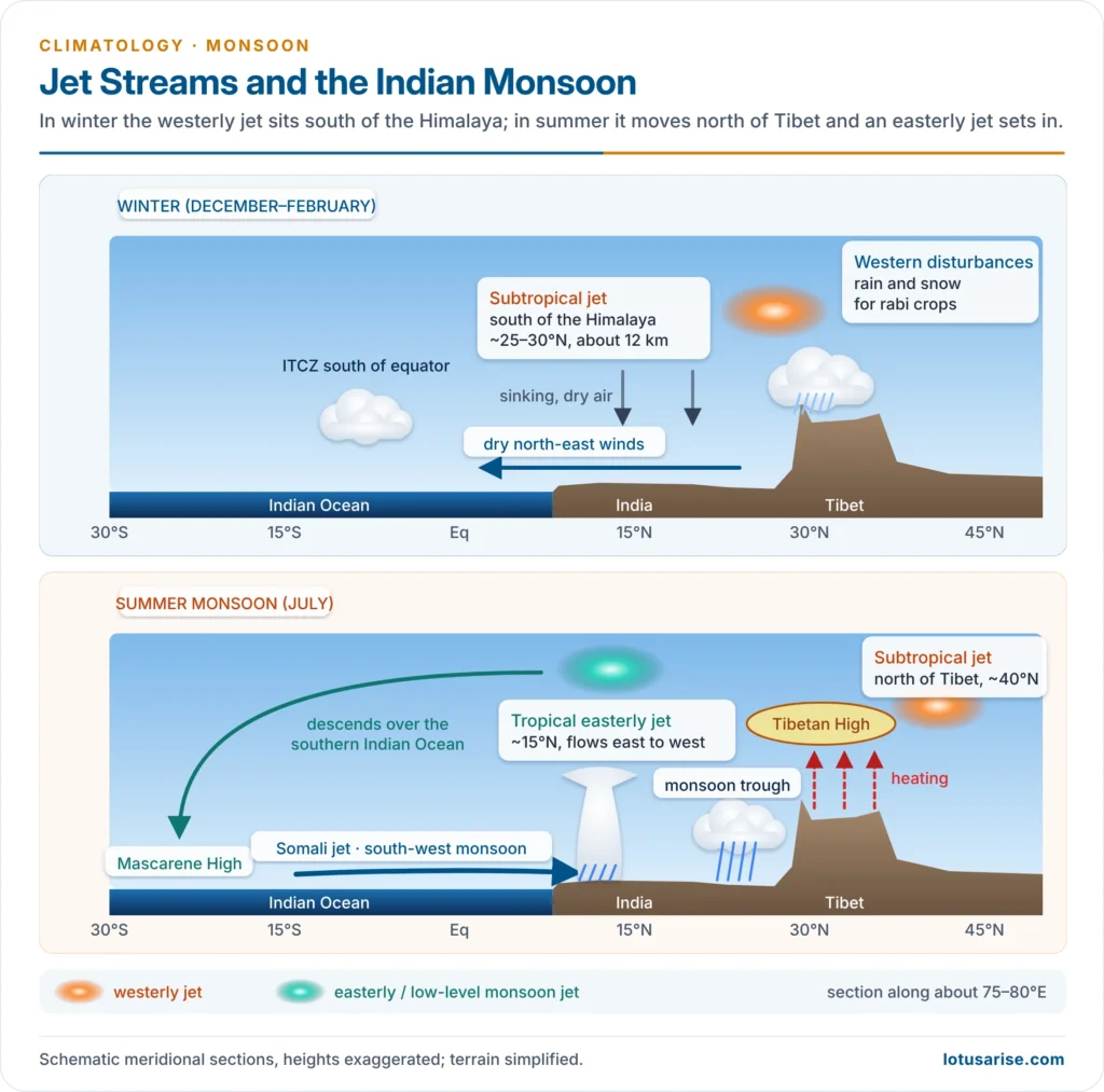
- Maung Tun Yin (1949) linked the onset to the subtropical westerly jet (STJ):
- In winter and spring the STJ blows south of the Himalaya; its westerly, subsiding flow blocks the monsoon current.
- In early June the jet leaves the south side of the plateau and re-forms north of Tibet (about 40°N). The monsoon then bursts over India within days.
- In mid-October the jet returns south of the Himalaya and the monsoon withdraws.
- He saw the Himalaya–Tibet massif as a mechanical barrier whose hydrodynamic effect, not the thermal low, times the onset.
- Criticism: some observations show the monsoon arriving before the jet’s northward jump, and the theory says little about rainfall amount.
Tibetan Plateau as Heat Source: P. Koteswaram (1958)
- P. Koteswaram (1958) identified the tropical easterly jet (TEJ) and traced it to summer heating of the Tibetan Plateau, about 2.5 million km² at an average height above 4,000 m.
- Mechanism:
- In summer the plateau surface heats the air directly at mid-tropospheric height, making it an elevated heat source.
- A warm-core anticyclone forms over it in the upper troposphere (about 200–100 hPa): the Tibetan (South Asian) High.
- On its southern flank an easterly jet develops near 15°N at about 100–150 hPa and extends west to Africa.
- The TEJ descends over the southern Indian Ocean, strengthening the Mascarene High; air from there flows north, crosses the equator as the Somali jet, and feeds the south-west monsoon.
- Latent heat released by monsoon rain strengthens the upper anticyclone, a positive feedback.
- In October the plateau cools, the anticyclone and TEJ collapse, the STJ returns and the monsoon retreats.
- Field evidence: the Indo-Soviet Monsoon Experiment (ISMEX, 1973) and the international MONEX (1979) confirmed the plateau’s role and the cross-equatorial low-level jet.
- Evaluation: William Boos and Zhiming Kuang (2010) argued from models that the Himalaya, by insulating warm, moist tropical air from cold, dry air to the north, matters more than plateau heating. The barrier versus heat-source debate continues.
Burst, Breaks and the Rain-Makers
- Burst: the onset is abrupt, with thunderstorms, a sharp fall in day temperature and a rise in humidity. Its normal date over Kerala is 1 June (about ±7 days); the monsoon covers the whole country by about 8 July.
- The 2025 monsoon reached Kerala on 24 May, its earliest since 2009; in 2026 it arrived on 4 June.
- Breaks: spells of a week or more with little rain over central India, when the monsoon trough shifts to the Himalayan foothills; the foothills and the north-east then get heavy rain.
- Rain-makers: the south-west current is a necessary but not sufficient condition. Rain comes from monsoon depressions and lows from the Bay of Bengal, the monsoon trough, offshore troughs and vortices on the west coast, and orographic uplift.
- The monsoon’s chief role is to fill the lower atmosphere with moisture; the disturbances supply the lift.
Teleconnections: Ocean–Atmosphere Theories
El Niño–Southern Oscillation (ENSO)
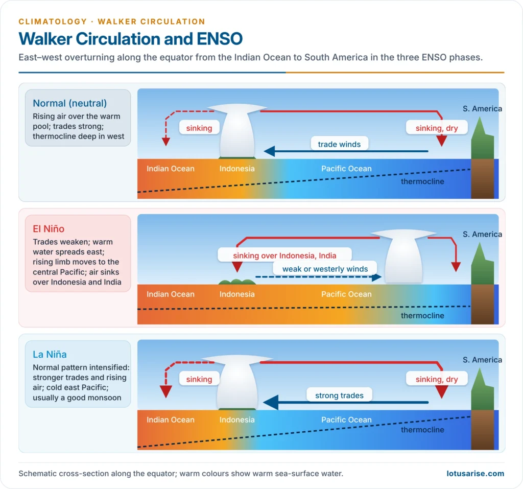
- Gilbert Walker, searching in the 1920s for predictors of the monsoon after the famines of the late nineteenth century, found the Southern Oscillation, the see-saw of pressure between the Indian Ocean and the South Pacific.
- Mechanism: in an El Niño, the rising limb of the Walker circulation shifts east into the central Pacific and air sinks over the Indian region. This weakens convection, the Tibetan High and the TEJ, so the monsoon is weaker. La Niña generally strengthens it.
- Evidence: 2002, 2009, 2015 and 2023 were El Niño years with deficient or below-normal monsoons; August 2023 was India’s driest August since 1901. The 2026 monsoon, under a developing El Niño, ended at about 87% of the long-period average, the lowest since 2015.
- Evaluation: the link is probabilistic, not fixed.
- K. Krishna Kumar, Balaji Rajagopalan and Mark Cane (1999) found it weakening after the 1980s; the strong El Niño of 1997 brought a near-normal monsoon.
- Central-Pacific (“Modoki”) El Niños tend to hurt the monsoon more than eastern ones, and the warming Indian Ocean and the IOD modulate the effect. Recent studies disagree on whether warming is weakening or strengthening the link.
Indian Ocean Dipole (IOD) and EQUINOO
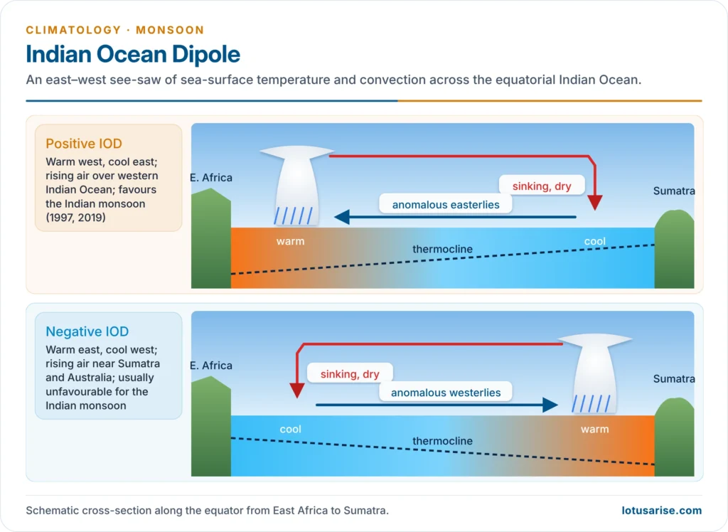
- The IOD, described by N. H. Saji, B. N. Goswami, P. N. Vinayachandran and Toshio Yamagata (1999), is the difference in sea-surface temperature between the western Arabian Sea and the eastern Indian Ocean off Sumatra.
- Positive IOD: warm west, cool east; rising air over the western Indian Ocean favours the Indian monsoon and can offset El Niño (1997; 2019, when the monsoon ended at 110% of normal).
- Negative IOD: warm east, cool west; generally unfavourable.
- The Equatorial Indian Ocean Oscillation (EQUINOO), the see-saw of convection between the western and eastern equatorial Indian Ocean, identified by Sulochana Gadgil and colleagues (2004), is its atmospheric partner and also helps explain monsoons that defy ENSO.
Madden–Julian Oscillation (MJO)
- The MJO, found by Roland Madden and Paul Julian (1971–72), is an eastward-moving pulse of tropical convection that circles the globe in about 30–60 days.
- Its northward-moving summer counterpart, the boreal summer intraseasonal oscillation, sets the active–break rhythm of the Indian monsoon and can advance or delay the onset.
Synthesis and the Changing Monsoon
| Theory | Proponent | Core idea | Main gap |
|---|---|---|---|
| Thermal | Edmond Halley (1686) | Seasonal land–sea pressure contrast | Burst, breaks, variability |
| Air-mass / ITCZ | — | Seasonal ITCZ migration draws equatorial air | Upper air; abrupt onset |
| Dynamic | Hermann Flohn (1951) | Shift of planetary belts; equatorial westerlies | Upper air; Tibet |
| Jet stream | Maung Tun Yin (1949) | STJ jumps north of Tibet, releasing monsoon | Rainfall amount; timing debated |
| Tibetan heat source | P. Koteswaram (1958) | Tibetan High, TEJ, Mascarene High chain | Barrier versus heating debate |
| Teleconnections | Gilbert Walker; later work | ENSO, IOD, MJO modulate strength and timing | Links shift over decades |
- Present understanding: the monsoon is a coupled land–ocean–atmosphere system. Its existence comes from the seasonal migration of the tropical rain belt over a large continent, its form from the Himalaya–Tibet massif, its rain from synoptic disturbances, and its year-to-year swings from ENSO, IOD and intraseasonal oscillations.
- Monsoon and warming:
- The IPCC (2021) attributes the decline of South Asian monsoon rain in the second half of the twentieth century mainly to aerosols, and projects monsoon rainfall to increase over South Asia in the long term as greenhouse warming dominates.
- Roxy Mathew Koll and colleagues (2017) found a threefold rise in widespread extreme rain events over central India between 1950 and 2015, even as moderate rain declined: fewer rainy days, heavier bursts.
Previous Year Questions
2026Define ‘pseudo monsoon’ and explain its spatial distribution.2026The relationship between El Niño and the Indian monsoon is becoming complex under the conditions of global warming. Critically examine.2020Explain how various factors influence the origin and development of the Indian monsoon system.2014Discuss the nature and origin of Indian monsoon and recent techniques of its prediction.2013Discuss the mechanism of Indian Monsoon.2008Discuss the mechanism and origin of Monsoon winds & explain the role of El Nino on Monsoon circulation.2006Give a critical account of the recent theories of origin of Indian monsoon with special reference to Jet Stream Theory.2002Explain the origin, mechanism and characteristics of Summer Monsoon in India.1999Elucidate the mechanism of the Indian Monsoon.1994Discuss the recent theories put forward to explain the origin and mechanism of the Indian Monsoon.




