

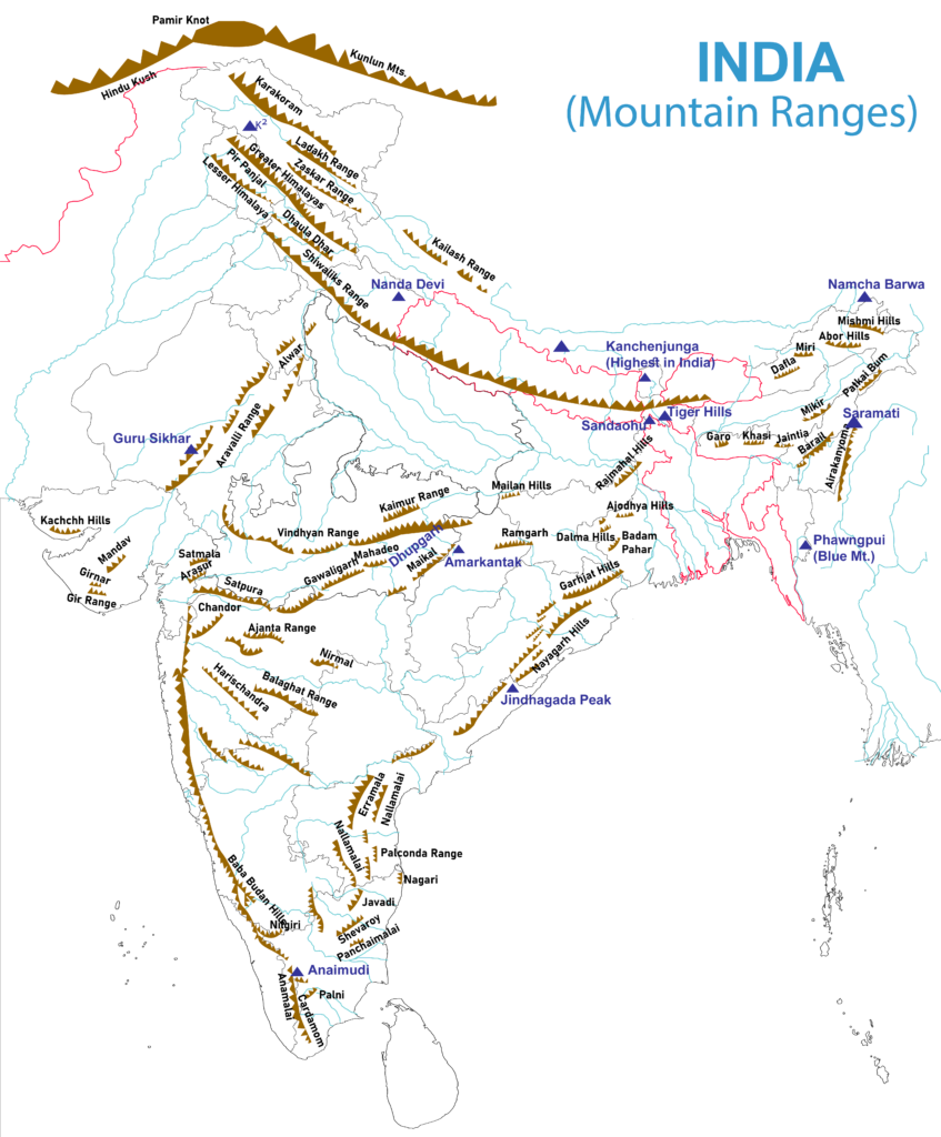
- This map marks Kanchenjunga as the highest in India, which holds only for the Himalaya proper. K2 (8,611 m) is the highest peak in India.
- The hill ranges of the Peninsula are far lower than the Himalaya. Most are relict, the eroded remains of higher land, and a few are true horsts raised between faults. The full list of ranges runs much longer than the five treated first here.
Important Hill Ranges of India
- Aravalli hills
- Vindhyan range
- Satpura range
- Western Ghat
- Eastern Ghat
- The last two are the Western and Eastern Ghats.
| Range | Length | Usual height | Origin | Highest point |
|---|---|---|---|---|
| Aravalli | About 700–800 km | 400–600 m | Ancient fold belt, now relict | Guru Shikhar, 1,722 m |
| Vindhya | Over 1,200 km | 300–650 m | Scarp above a rift; old sediments | Sadbhawna Shikhar |
| Satpura | About 900 km | 900–1,000 m on its high hills | Horst | Dhupgarh, 1,350 m |
| Western Ghats | About 1,600 km | 1,000–1,200 m and rising south | Faulted edge of the plateau | Anai Mudi, 2,695 m |
| Eastern Ghats | Broken chain | 900–1,200 m in the north | Detached, mixed hills | Arma Konda, 1,680 m |
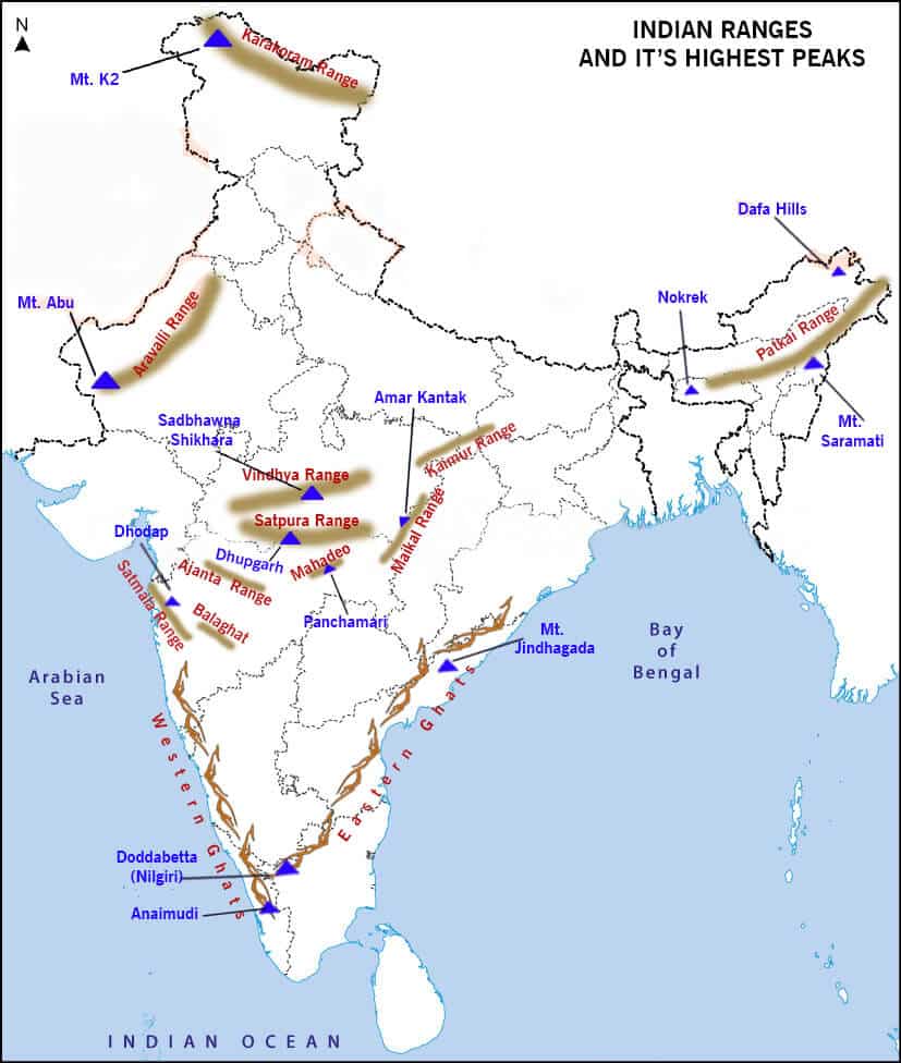
- On this map Mt. Abu marks the massif, whose summit is Guru Shikhar. “Dafa Hills” and “Panchamari” are Dapha Bum in the Mishmi Hills and Pachmarhi. The map shows a rough outline only, not official boundaries.
Aravalli Hills
- Extent: they begin in Gujarat at Palanpur and run through Rajasthan to Haryana, ending at the Delhi Ridge.
- They may continue under the alluvium as far as Haridwar.
- Maximum extent is 800 km. Reviews also give about 700 km for the fold belt.
- Old fold mountains, among the oldest tectonic mountains in the world. Their rocks are more than 2 billion years old.
- Average elevation is only 400–600 m, unlike other fold mountains, because of long weathering and erosion through their geological history.
- Few peaks pass 1,000 m.
- Mt. Gurushikhar (1,722 m) is the highest point.
- Mt. Abu (1,158 m) is part of a small plateau, cut off from the main range by the Banas valley.
- Along the range: a chain of detached ridges from Delhi to Ajmer, then a continuous range at about 900 m south of Ajmer.
- Geology: older accounts call them mainly Dharwar igneous and metamorphic rock. The current account has Palaeoproterozoic Aravalli and Mesoproterozoic Delhi supergroups resting on an older gneissic basement.
- Their past is argued:
- Darashaw Nosherwan Wadia held that they ran as a continuous lofty chain from the Deccan to beyond Garhwal, of which today’s hills are the stumps.
- Maharajapuram Sitaram Krishnan saw one branch reaching the Lakshadweep through the Gulf of Khambhat and another into Andhra Pradesh and Karnataka.
- Shiba Prasad Chatterjee placed the first folding on the site of an old geosyncline at 600–700 million years ago. That age is far too young against current dating. He also saw the range as India’s old watershed, with glaciers on its summits.
- The worn-down range was raised again about 100 million years ago, on the same account: at least 1,200 m around Udaipur, tapering to 200 m at the Delhi and Ahmedabad ends.
- Minerals: the largest marble deposits in India.
- Rivers:
- The Banas, Luni and Sabarmati rise here.
- The Banas joins the Chambal.
- The Luni is an ephemeral river that ends in the Rann of Kutch.
- Passes cut through them, especially between Udaipur and Ajmer: Barr, Piplighat, Dewair and Desuri.
- Lakes:
- Sambhar, the largest inland saline water body in India.
- Dhebar, south of the Aravalli, in the Jaisamand Wildlife Sanctuary. Dhebar and Jaisamand are the same lake, not two, as older lists suggest.
- Protection and law:
- In November 2025 the Supreme Court accepted a definition of an Aravalli hill as a landform 100 m or more above local relief.
- By an order of 29 December 2025 it kept that judgment in abeyance and barred fresh mining permissions without its leave. The stay has continued since. In June 2026 the Court set up a high-powered expert committee to review the definition, and it has refused to extend the panel’s time beyond 30 November 2026.
- The Union Environment Ministry told the States in December 2025 to stop granting new mining leases across the range.
Vindhyan Range
- Non-tectonic mountains, in the sense that they did not rise from plate collision. They stand as a scarp because the Narmada Rift Valley to their south faulted down.
- Extent: about 1,200 km to Sasaram in Bihar. The western end is given as Bharuch in Gujarat in older accounts and Jobat, near the Gujarat border, in other accounts.
- Geologically younger than the Aravalli and Satpura hills.
- Average height 300–650 m, rarely above 700 m.
- Rocks: older Proterozoic rocks in almost horizontal beds, with lava covering the western part.
- Kimberlite pipes (diamond deposits) cut across them, as at Majhgawan near Panna.
- Local names: Panna, Kaimur, Rewa and others. It continues east as the Bhanrer and Kaimur hills.
- Form: they rise from the rift in steep, sharp escarpments, well developed in the Kaimur and Panna regions. The northern slope is gentle.
- Divide: it separates Ganga-bound drainage from the rivers of the south, and edges the Deccan on the north. The heads of the Chambal, Betwa and Ken lie no more than 30 km from the Narmada.
Satpura Range
- A combination of the Satpura, Mahadeo and Maikala hills, beginning at the Rajpipla Hills. The name is read as “seven mountains”.
- Tectonic mountains, formed about 1.6 billion years ago by folding and structural uplift. They are a horst landform.
- They run for about 900 km, between the Narmada and Tapi.
- Mahadeo Hills lie east of the Satpura hills.
- Pachmarhi is the highest part of the range, and Dhupgarh (1,350 m) its highest peak. Astamba Dongar (1,325 m) comes next.
- Maikala Hills lie east of the Mahadeo Hills, and include the Amarkantak plateau at about 1,127 m.
- That plateau feeds both the Narmada and the Son, and so drains to both the Arabian Sea and the Bay of Bengal.
- States: mostly Madhya Pradesh and Chhattisgarh.
- Bauxite: these hills are rich in it. Older accounts tie this to Gondwana rocks, though the ore on the Maikala comes from laterite weathering of the plateau surface.
- Dhuandhar Falls on the Narmada lie in Madhya Pradesh.
Other Named Hills and Series
| Hill or series | Location | Notes |
|---|---|---|
| Maikal Range | MP | Eastern part of the Satpura |
| Kaimur Range | MP, UP, Bihar | Eastern Vindhya, parallel to the Son |
| Mahadeo Range | MP | Central Satpura; highest peak Dhupgarh |
| Ajanta Range | Maharashtra, south of the Tapi | Caves with paintings of the Gupta age |
| Rajmahal Hills | Jharkhand | Basaltic lava; the Ganga turns here before it divides (Ganges) |
| Garo, Khasi, Jaintia Hills | Meghalaya | Continuous hill belt |
| Mikir Hills | Assam, south of Kaziranga National Park | Part of the Karbi Anglong Plateau |
| Abor Hills | Arunachal Pradesh, near China | Next to the Mishmi and Miri Hills; Dibang, a Brahmaputra tributary |
| Mishmi Hills | Arunachal Pradesh, touching China on north and east | Junction of the north-eastern Himalaya and Indo-Burma ranges |
| Patkai Range | Myanmar border | See below |
| Koubru Hill | Manipur | Also Mount Koupalu; see below |
| Mizo (Lushai) Hills | Mizoram, partly Tripura | Part of the Patkai system |
| Dalma Hills | Near Jamshedpur | Dalma sanctuary; iron ore, manganese |
| Dhanjori Hills | Jharkhand | |
| Girnar Hills | Gujarat | |
| Baba Budan Giri | Karnataka | |
| Harishchandra | Near Pune | Water divide, Godavari and Krishna; lava |
| Balaghat range | See below | Manganese belongs to another Balaghat |
| Chilpi series | MP | A rock series |
| Talcher series | Odisha | See below |
| Champion series | Karnataka | Dharwar age; gold, Kolar mines |
| Nilgiri Hills | Western Tamil Nadu | Called the Blue Mountains; see below |
| Palani Hills | Tamil Nadu | Eastward extension of the Western Ghats |
| Anamalai Hills | Tamil Nadu, Keralam (Kerala) | Elephant Hills; highest peak Anamudi |
| Cardamom Hills | South-east Keralam, south-west Tamil Nadu | Southern Western Ghats |
| Pachamalai Hills | Tamil Nadu | The Pachais, in the Eastern Ghats |
| Parasnath Hill | Giridih, Jharkhand | Peak of the Parasnath Range, 1,366 m |
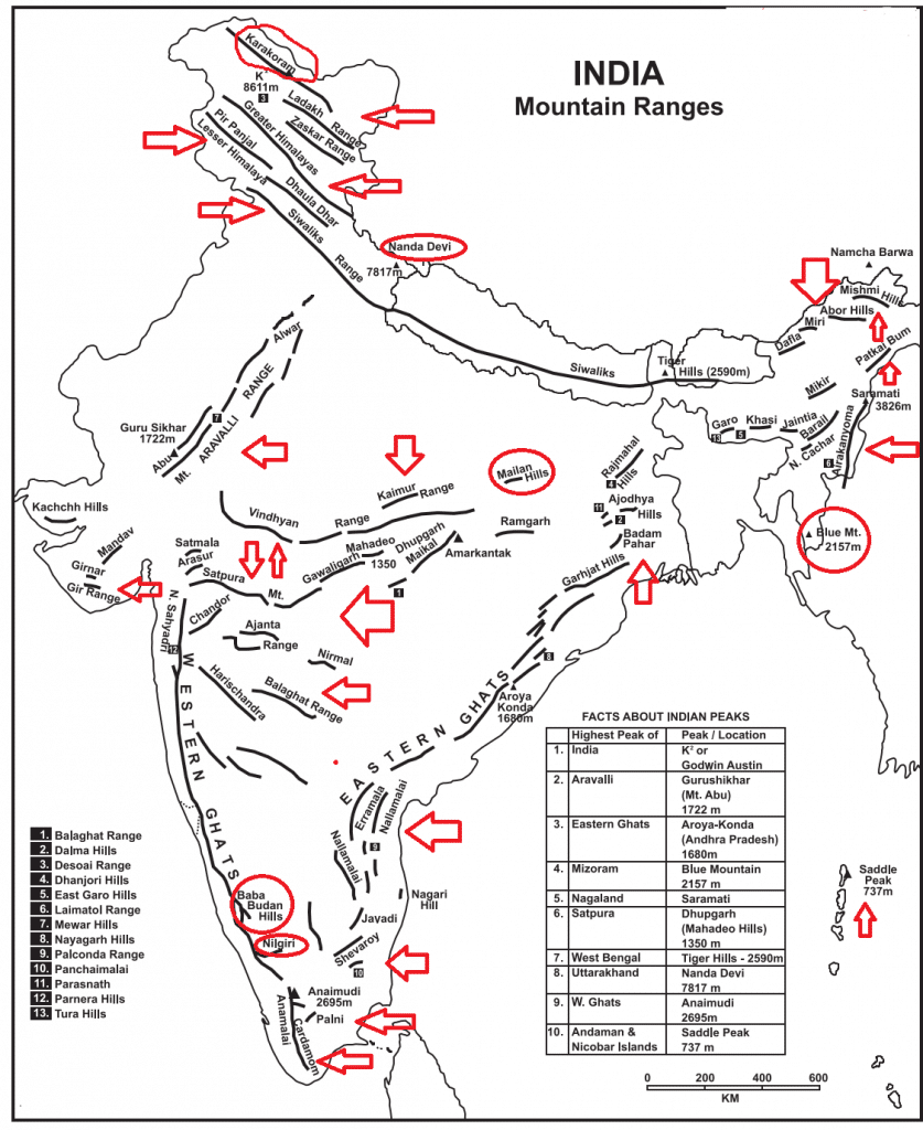
- On this map Tiger Hills is not West Bengal’s highest point: Sandakphu (3,636 m) is. “Aroya Konda” is Arma Konda.
- Notes on the table:
- Patkai Range: often called the Purvanchal Range, on India’s north-eastern border with Burma (Myanmar). It has been listed with the Patkai Bum, the Garo–Khasi–Jaintia and the Lushai Hills. The Meghalaya hills are in fact a block of the Peninsula, set apart by the Garo–Rajmahal gap, so they do not belong to it structurally.
- Koubru Hill: one of the highest mountains in Manipur, and in Manipuri mythology the abode of the god Lainingthou Koubru and the goddess Kounu.
- Balaghat: the Balaghat Range is a Western Ghats spur in Maharashtra. The manganese famous under that name lies in Balaghat district of Madhya Pradesh, on the MP–Maharashtra side. Older lists merged the two.
- Talcher: the Talchir series itself is a glacial boulder bed at the base of the Gondwana. Talcher’s bituminous coal in Odisha comes from the beds above it.
- Champion series: the Kolar field closed in 2001.
- Ajanta: the paintings span a long period, and the main phase is contemporary with the Gupta age.
- Nilgiri Hills: at the junction with Karnataka and Keralam. The Moyar River separates them from the Karnataka plateau, and the Palghat Gap from the Anaimalai and Palani Hills to the south.
- Palani Hills: they adjoin the high Anamalai range on the west and run east into the plains of Tamil Nadu.
- Parasnath lies towards the eastern end of the Chota Nagpur Plateau.
Previous Year Questions
1987Give the salient features of the Aravalli with respect to geologic structure, relief and impact on human settlements.





 History Optional PYQ Master Pack: Topic-wise Model Answers (1985–2025) by LotusArise IAS
 History Optional Mains Master Kit 2027 Complete Self-Study System — Notes, Mapping & Premium Articles by LotusArise IAS
Dear Sir agr aapke ye topic wise notes cover kre to Enough h kya Optional ke liye ??
Dear Mohit, You have to read the basics of NCERT, GC Leong, and other standard books. but If you have less time then you can read our articles, and do value addition from current affairs/magazine.
good content very beneficial
Dhupgarh and panchamari hills are marked incorrectly
eastern ghat highest peak is “Jindhagada Peak(1690 mt) not arma konda
Arma konda is the highest peak on R Godavari catchment area
Jindhagada Peak, the highest peak in the Eastern Ghats, is also known as Arma Konda or Sitamma Konda
Excellent
Geologically, they are younger than Aravallis and Satpura hills.Is this correct please explain
Regarding Vindhya