

- The Brahmaputra, whose name means son of Brahma, is a trans-boundary river of Tibet (China), India and Bangladesh, and in the Indian part of its basin it is the country’s largest river by volume, carrying about 527 BCM a year.
- Its upper course is the Tsangpo of Tibet, its middle course the Dihang (Siang) of Arunachal Pradesh, and its lower course the Jamuna of Bangladesh.
- Arunachal Pradesh is an integral part of India, and the river’s Indian stretch begins there.
The Main River
Source and Length
- Source: the Chemayungdung glacier in south-western Tibet, in the Kailas Range, at about 30°31’N, 82°10’E and 5,150 m. It lies close to the sources of the Indus (about 150 km away) and the Satluj (about 35 km).
- Mariam La separates this source from Lake Manasarovar.
- In 2011, a Chinese Academy of Sciences study placed the longest headstream on the Angsi glacier.
- Length: classically 2,900 km, with about 1,625–1,800 km in Tibet, about 916–918 km in India and about 337 km in Bangladesh. The 2011 study gives 3,848 km.
- Basin: about 5.8 lakh sq km in older accounts, and 7,12,035 sq km in the 2011 study.
- In India: older figure 2,58,008 sq km (7.8%), including the Barak side. CWC 2019 gives 1,93,252 sq km for the Brahmaputra proper, and 86,335 sq km for the Barak and others.
- States: mainly Assam, Arunachal Pradesh and Sikkim, with northern Nagaland and Meghalaya.
Course in Tibet
- In Tibet it passes along the Indus–Tsangpo Structure Zone, a depression between the Great Himalaya to the south and the Kailas Range to the north, for about 1,800 km.
- A sluggish river at great height: despite the altitude, it has a gentle slope and a wide channel navigable for about 640 km below Lhatse Dzong, one of the world’s highest waterways. Its bed is about 3,525 m at Tradom and 3,300 m at Shigatse.
- Tibetan tributaries:
- The first major one is the Raga Tsangpo, meeting it near Lhatse Dzong.
- The Ngangchu flows past Gyantse, and the Kyichu past Lhasa, joining near Chushul Dzong. The Gyamda joins from the north.
- In the south-east it runs through rapids between Namcha Barwa (7,782 m; 7,756 m in older lists) and Gyala Peri (7,151 m), then swings round in the Great Bend.
Course in India
- It breaks through the Himalaya in great gorges into Arunachal Pradesh, known first as the Siong (Siang) and then the Dihang.
- The gorge narrows to about 50 m in places and lies about 5,485 m below the summit of Namcha Barwa. Between a point north of the peak and Sadiya, the bed drops from about 2,450 m to about 135 m.
- Just west of Sadiya, the Dihang turns south-west and takes two mountain rivers, the Lohit and the Dibang. Seen on a map, the three look like a “delta in reverse”.
- Below this confluence it is called the Brahmaputra. It runs through the Assam Valley for about 640–720 km.
- Channel:
- Braided for most of Assam, with constantly shifting channels and sand shoals, a heavy silt load and meandering.
- About 16 km wide at Dibrugarh.
- The channel has been moving south across the Assam plains in recent decades.
- It rounds the Garo Hills, turns south, and enters Bangladesh near Dhubri.
Course in Bangladesh
- It flows as the Jamuna for about 270–337 km to meet the Ganga at Goalundo, and the combined stream is the Padma.
- About 105 km on, the Meghna joins on the left bank. The combined river keeps the Meghna name and reaches the sea through a wide estuary.
- Together with the Ganga, it builds the vast delta whose seaward part is the Sundarbans (Sunderbans).
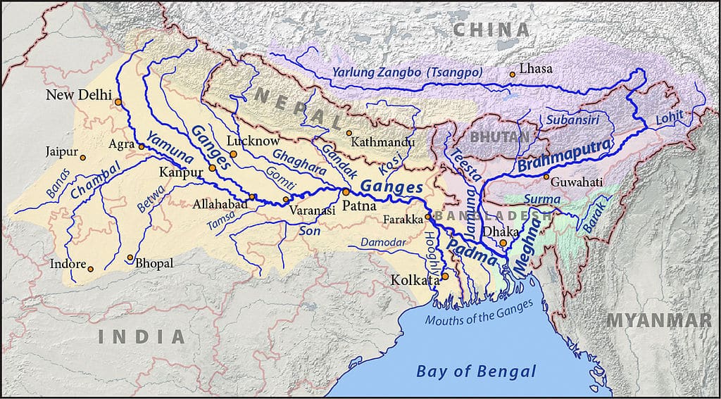
Names of the River
| Region | Name |
|---|---|
| Tibet | Tsangpo (meaning “The Purifier”) |
| China | Yarlung Zangbo Jiang |
| Arunachal Pradesh | Siong (Siang) or Dihang |
| Assam Valley, below Sadiya | Brahmaputra |
| Bangladesh | Jamuna |
| Bangladesh | Padma: combined waters of the Ganga and Brahmaputra |
| Bangladesh | Meghna: from the confluence of the Padma and Meghna |
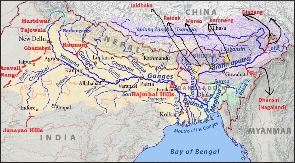
- On this map, “Kamneng” is the Kameng, “Diabang” is the Dibang and “Rajmhal” is the Rajmahal hills.
Islands and Urban Centres
- The world’s biggest and smallest inhabited river islands are held to lie on the river in Assam: Majuli and Umananda.
- Majuli: often given as 1,250 sq km, 90 km long and 20 km wide at its widest, with 144 villages. Current official work, excluding other land in the district, puts the main island at 524.29 sq km in 2016, against 734 sq km in 1914 and a low of 502.21 sq km in 2004.
- Erosion grew severe after the 1950 earthquake. Protection work has since allowed a small gain in land.
- Important urban centres on the river are Dibrugarh, Pasighat, Neamati, Tezpur and Guwahati.
Floods and Navigation
- Monsoon concentration of rain sends huge volumes of water and silt into the valley, and has earned the river the title “River of Sorrow”.
- Older accounts claim an average of 8–10 lakh sq km flooded each year. That is impossible, since Assam itself covers only about 78,523 sq km. The right figure is 9.31 lakh hectares, about 9,310 sq km, from a flood-prone area of 31.05 lakh hectares, nearly 40% of the State.
- Navigation: the river is navigable for about 1,384 km from its mouth to Dibrugarh, and remains a useful inland water route.
Water Issues with China
- China’s Medog (Motuo) project:
- China began the Yarlung Tsangpo hydropower project on 19 July 2025, near the Great Bend, with five cascade stations, a planned capacity of about 60 GW and a cost of about 1.2 trillion yuan.
- India fears sudden releases and changed seasonal flows. An Assam government estimate puts China’s share of the river’s total flow at only 30–35%, the rest being generated in India.
- India’s Siang Upper Multipurpose Project: a proposed 11,200 MW storage dam in Arunachal Pradesh, intended partly as a buffer. As of October 2026 it is still at preliminary feasibility stage, unapproved, and opposed locally over displacement.
- Data sharing: a 2002 memorandum arranged for China to give flood-season data from 1 June to 15 October.
Major Tributaries of the Brahmaputra River
- Left bank: Dhansiri, Lohit, Dibang, along with the Burhi Dihing, Dibru, Noa Dihing, Dikhu, Kalang, Kolong and Kopili.
- Right bank: Subansiri, Kameng, Manas, Sankosh, along with the Belsiri, Dhansiri (north), Beki, Raidak, Jaldhaka and Teesta.
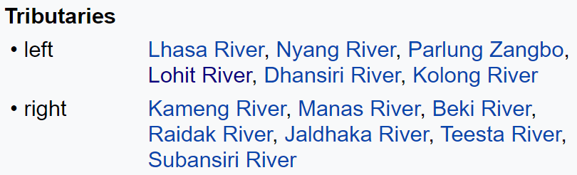
- In Tibet, the left-bank list also has the Lhasa, Nyang and Parlung Zangbo.
Subansiri River
- Also called the Gold River, famous for its gold dust.
- It flows through Lower Subansiri district in Arunachal Pradesh, and runs for about 160 km across the upper Assam plain.
- It is a swift river with excellent kayaking opportunities.
- Subansiri Lower Project (2,000 MW): on the Arunachal–Assam border at Gerukamukh. By 24 October 2026, five of its eight 250 MW units, 1,250 MW in all, were in commercial operation, and the rest are scheduled by December 2026.
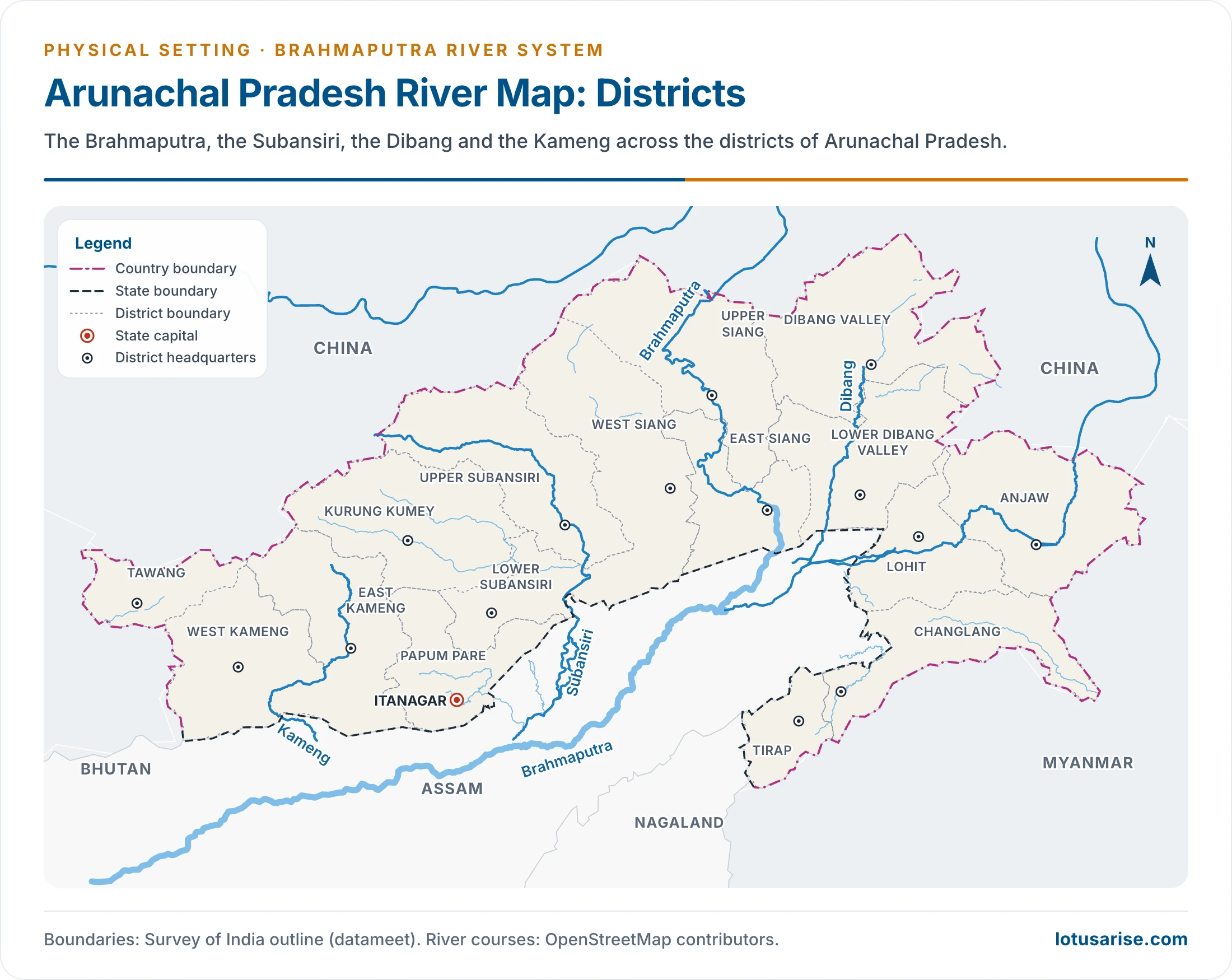
Kameng River
- It rises in Tawang district, in the eastern Himalaya.
- It flows through West Kameng district of Arunachal Pradesh and Sonitpur district of Assam, where it is known as the Jia Bharali.
- It forms the boundary between East and West Kameng districts.
- Pakhui (Pakke) Wildlife Sanctuary and Kaziranga National Park lie near it.
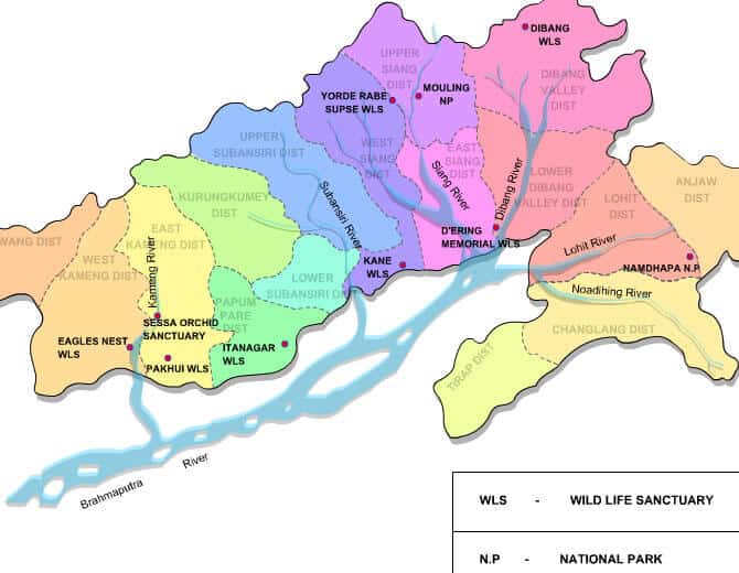
Manas River
- A trans-boundary Himalayan foothill river between southern Bhutan and India.
- It runs 376 km: 272 km through Bhutan and 104 km through Assam, and joins the Brahmaputra at Jogighopa.
- Older accounts treat it as antecedent, with its head in Tibet.
- The valley holds two major protected forests: Royal Manas National Park in Bhutan and the contiguous Manas Wildlife Sanctuary in India.
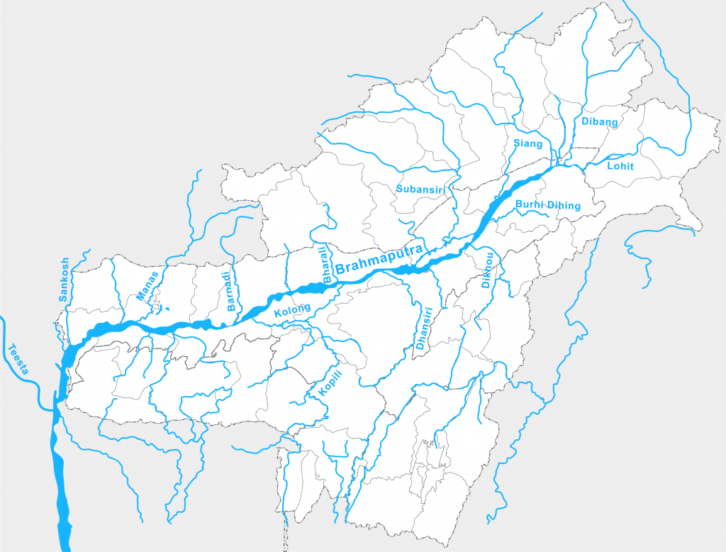
Sankosh River
- It rises in northern Bhutan and enters the Brahmaputra in Assam.
- Its upper catchment is glaciated. Its middle and lower courses flow along V-shaped valleys cut by running water.
- The entire catchment is forested.
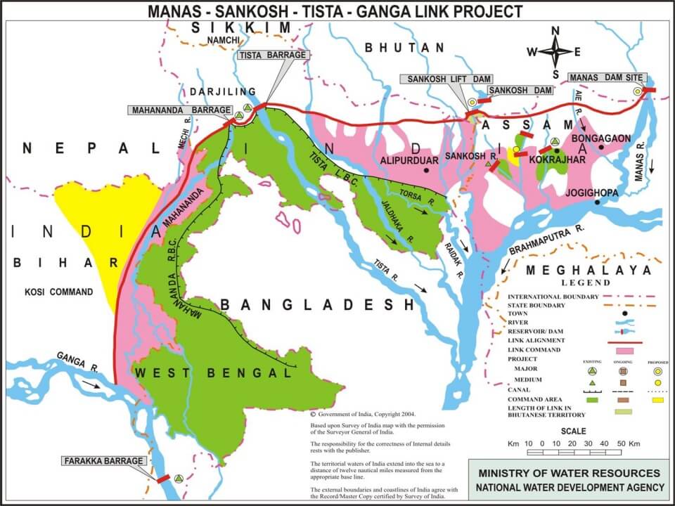
- The Manas–Sankosh–Tista–Ganga link is a proposed Himalayan-component project of the national plan, shown on the map below, to carry surplus north-eastern water to Farakka.
Teesta River
- It rises at Tso Lhamo lake in North Sikkim, at about 5,330 m.
- The Rangeet is its main tributary and joins it at Tribeni. Older accounts call the Rangeet Sikkim’s largest river, but that is the Teesta itself.
- It then passes Rangpo and forms the Sikkim–West Bengal border to Teesta Bazaar.
- It flows through Jalpaiguri and on to Rangpur district of Bangladesh, before merging with the Brahmaputra.
- Change of course: it was a tributary of the Ganga until the great floods of 1787 turned it east.
- Current issues:
- The India–Bangladesh sharing deal has been stalled since 2011.
- Glacial lake flood of 3–4 October 2023: the outburst of South Lhonak Lake swept down the valley and destroyed a hydroelectric dam at Chungthang.
- Teesta-VI (500 MW) is under construction, scheduled for September 2029.
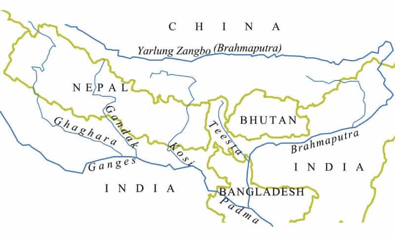
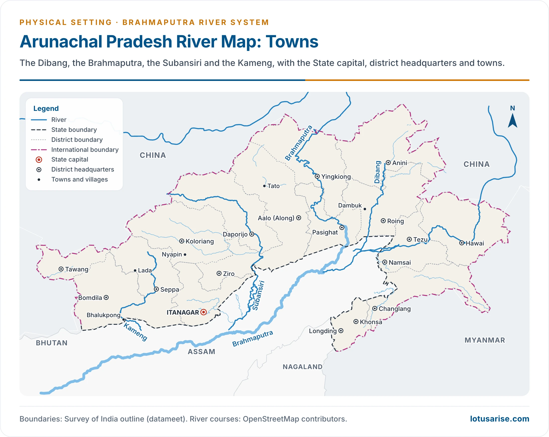
Dibang River
- One of the principal tributaries of the Brahmaputra, also called the Sikang.
- It starts on the snow-covered southern flank of the Himalaya near the Tibet border, above 5,000 m.
- It enters the plain near Nizamghat in Lower Dibang Valley district of Arunachal Pradesh.
- The Mishmi hills line its upper course.
- Dibang Multipurpose Project (2,880 MW) is under construction, scheduled for February 2032.
Lohit River
- It rises in eastern Tibet.
- It crosses the Mishmi hills to meet the Siang at the head of the Brahmaputra valley.
- Its valley is thickly forested, with alpine and sub-tropical vegetation.
- It also has many medicinal plants.
Dhansiri River
- The main river of Golaghat district in Assam and Dimapur district in Nagaland.
- It rises in Nagaland, and runs for about 300 km through Assam to the Brahmaputra.
- Its course has many perennially waterlogged swamps.
Kopili River
- An inter-State river of Meghalaya and Assam, and the largest south-bank tributary of the Brahmaputra in Assam.
- Carissa kopilii, a plant species, grows sparsely along its bed. The plant is threatened by a hydroelectric project and by water turned acidic through coal mining upstream in Meghalaya.
- Headward erosion by the Kopili is thought to have captured upper waters that once fed the Meghna.
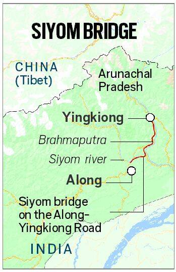
Siyom River
- A right tributary of the Brahmaputra.
- It rises south of the main Assam Himalaya ridge, not far from the Tibet border.
- Mouling National Park lies on its east bank.
- It flows first south, then east and south, through West Siang district. The Saje is its most prominent tributary.
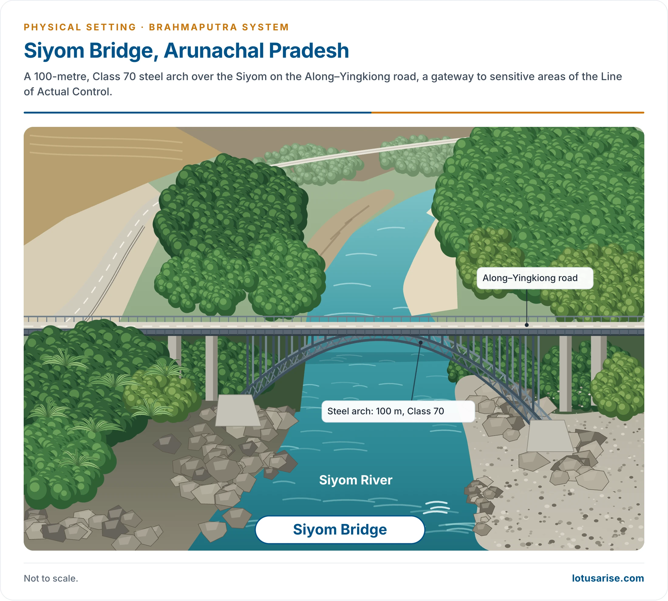
- Siyom Bridge:
- A modern 100-metre, Class 70 steel arch over the Siyom in Arunachal Pradesh, on the Along–Yingkiong road.
- It has great strategic significance, as a gateway to sensitive areas of the Line of Actual Control.
Important Cities on Brahmaputra
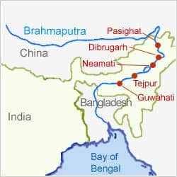
- “Tejpur” on this map is Tezpur.
Major River Valley Projects, Dams and Barrages in the Brahmaputra Region
| State | Projects |
|---|---|
| Arunachal Pradesh | Tawang, Subansiri Lower, Ranganadi, Paki, Papumpap, Dhinkrong, Upper Lohit, Damway, Kameng |
| Sikkim | Rangit, Teesta |
| Assam | Kopili |
| Meghalaya | New Umtru |
| Nagaland | Doyang |
| Manipur | Loktak, Tipaimukh |
| Mizoram | Tuibai, Tuirial, Dhaleshwari |
- The projects listed for Manipur and Mizoram lie outside the Brahmaputra proper: Tipaimukh and the Mizoram streams belong to the Barak side, and the Loktak drains towards the Chindwin through the Manipur River.
- Other Arunachal projects are being taken up. Etalin (3,097 MW) and Subansiri Upper (1,605 MW) are at the clearance stage.
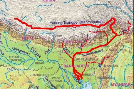
- On this map, “Gangak” is the Gandak and “Swarnarekha” is the Subarnarekha.
Previous Year Questions
2026Map item: Lohit River





Very very helpful 😍😍😍😍😍🥰🥰🥰 amazing superb content . I have no words to appreciate it. 🤗🤗🤗🤗🤗🤗😍😍😍🥰🥰🥰
Outstanding work done by you sir…as usual.
Thank you so much for providing these for free.🙏🙏
Most helpful site organised by lotusarise,it is more beneficial for NCERT understanding and upsc advance classes if you have done this , you are able to solve the 60-70percent questions of geography.
nailed it , the whole illustration both pictorial and theory written.. it is good in content moreover, amused while reading