

- Local winds are small-scale (meso- and microscale) winds confined to a limited area and the lowest few kilometres of the troposphere. Together they form the tertiary circulation, nested within the planetary and seasonal types of wind.
- They arise in three ways:
- local temperature contrasts between land and sea or slope and valley, which give diurnal breezes
- relief, which makes air descend and warm (föhn) or drain downhill when cold (katabatic and fall winds)
- advection of air from a hot or cold source region, drawn by a passing depression or pushed by an anticyclone
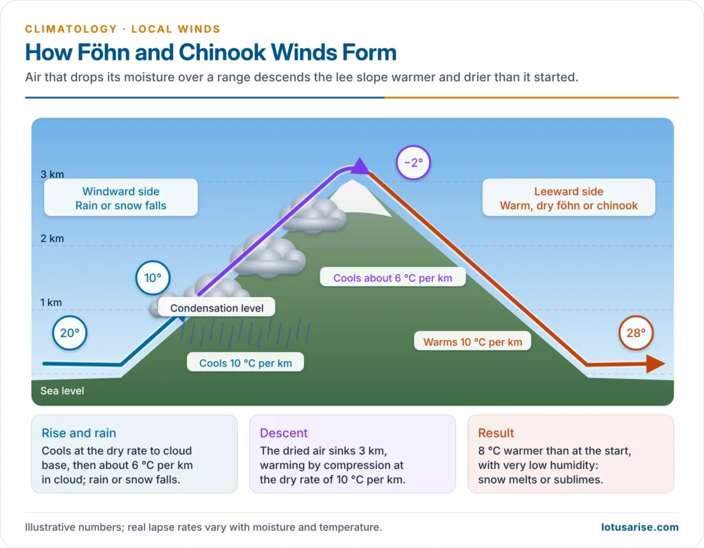
- Each has a local name; they are grouped as diurnal breezes, hot winds and cold winds.
Diurnal Breezes

Land and Sea Breezes
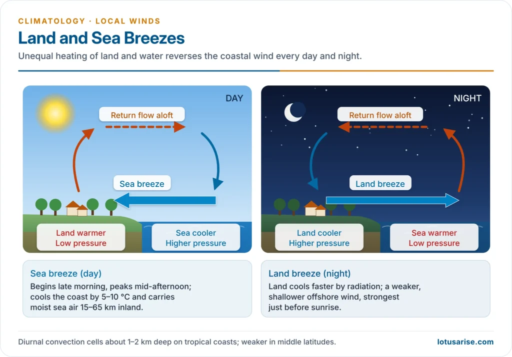
- Cause: the daily differential heating of land and water; because they reverse every day, they are called a diurnal monsoon.
- Sea breeze (day):
- The land warms faster, air over it rises and pressure falls; cooler air flows from sea to land, with a return flow aloft.
- It begins about 10–11 a.m., peaks in the mid-afternoon at about 10–20 km/h, and is 1–2 km deep in the tropics.
- It penetrates 15–50 km inland in middle latitudes and 50–65 km in the tropics, and can cool coasts by 5–10 °C. The sea-breeze front often sets off afternoon thunderstorms.
- Land breeze (night): the land cools faster, so air flows from land to sea. It is weaker and shallower, strongest just before sunrise.
- Where strongest: tropical coasts and islands, especially beside cold currents, where daily atoll clouds form. Lake breezes cool cities such as Chicago; Perth’s relieving sea breeze is the Fremantle Doctor.
- Indian examples: fishermen of the Kerala and Konkan coasts traditionally sail out on the land breeze before dawn and return on the sea breeze; a late sea breeze makes Chennai afternoons oppressive.
Mountain and Valley Breezes
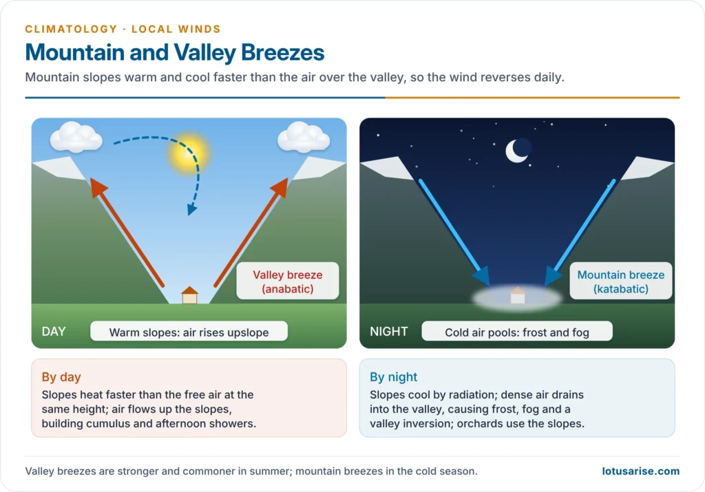
- Cause: the slopes are heated and cooled faster than the free air at the same height over the valley.
- Valley breeze (anabatic wind), day:
- Sun-warmed slopes heat the air in contact; it rises up the slopes and air flows up the valley.
- It builds cumulus over peaks and ridges and afternoon showers, and is stronger and more common in summer.
- Mountain breeze (katabatic wind), night:
- Slopes cool by radiation; dense, cold air drains downslope into the valley floor.
- It collects as a cold pool, producing frost, fog and a valley inversion; it prefers the cold season.
- Indian example: Himalayan valleys such as Kullu and Kashmir have strong afternoon up-valley winds with cloud on the ridges, and cold night drainage that fills valley floors with frost and fog. Orchards are therefore planted on the warmer slopes.
Large Katabatic (Fall) Winds
- Very cold, dense air collected over a plateau or ice sheet can pour downhill as a strong gravity, drainage or fall wind: persistent gales off Antarctica and Greenland, the bora and mistral, and the williwaw of the Strait of Magellan and Alaska.
- It warms by compression on descent but still arrives colder than the air it replaces.
Hot Local Winds
- Hot local winds are of two kinds:
- Föhn-type: air warmed dynamically by descending a mountain slope
- Advective: hot, dry, often dusty air drawn out of deserts, usually ahead of a depression
Föhn and Chinook
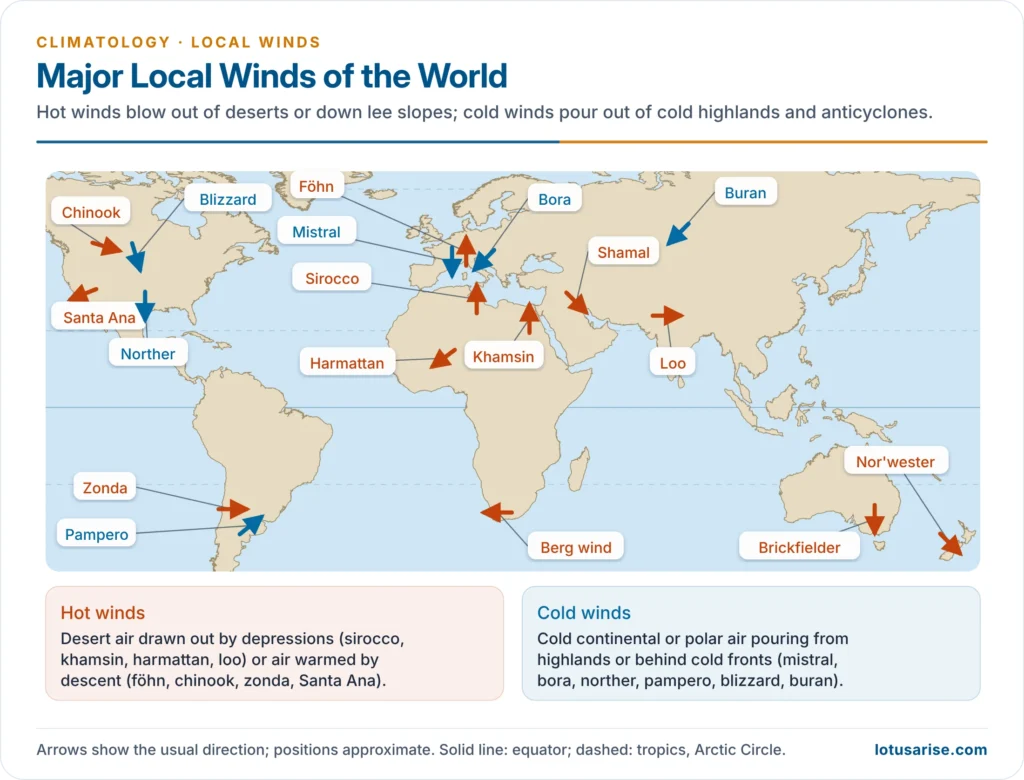
- Mechanism: moist air forced over a range cools at the saturated adiabatic rate (about 5–6 °C per km) once cloud forms and drops its moisture on the windward side. The dry air then descends the lee slope and warms at the dry adiabatic rate (about 10 °C per km), arriving much warmer and drier than at the same height on the windward side.
- A depression on the lee side usually draws the air across, so föhn winds are commonest in winter and spring.
- Föhn: a warm, dry, gusty wind of the Alps, best known on their northern side in Switzerland and Austria.
- Temperature rises sharply and humidity drops; it melts snow, opens pastures early, helps ripen grapes, and raises avalanche and fire risk.
- Chinook (“snow eater“): the föhn of the eastern slopes of the Rockies (Alberta, Montana, Wyoming).
- Snow can vanish by sublimation, keeping winter grasslands open for ranchers, at the cost of soil moisture.
- At Spearfish, South Dakota (22 January 1943) the temperature jumped from −20 °C to +7 °C in two minutes; at Loma, Montana (14–15 January 1972) it rose about 57 °C in 24 hours, a US record.
- Other föhn-type winds: the zonda (eastern Andes, Argentina), the nor’wester (Canterbury Plains, New Zealand) and the berg wind (South Africa).
- Santa Ana (southern California): hot, very dry air from the Great Basin high, warmed by compression as it descends to the coast.
- It drives wildfires: the Palisades and Eaton fires of January 2025 killed 31 people and destroyed over 16,000 structures around Los Angeles.
- Indian example: monsoon air sheds its moisture on the Western Ghats and descends drier and warmer over the Deccan rain-shadow, a föhn effect.
Sirocco and Other Desert Winds
- Sirocco: a hot, dry, dusty southerly wind from the Sahara, drawn north over the central Mediterranean on the front (eastern side) of depressions moving east along the sea.
- In Libya and Tunisia it is scorching and dust-laden; after crossing the sea it reaches Sicily and southern Italy warm and humid, sometimes with “blood rain” coloured by red dust.
- It withers vines and olives, causes respiratory distress, and is commonest in spring and autumn.
- It is called leveche in Spain, leste in Madeira and the Canaries, and ghibli in Libya.
- On 23 April 2024, southerly winds carried a Saharan dust plume over Athens, turning the sky orange.
- Khamsin: a hot, sand-laden southerly of Egypt in spring; simoom: a suffocating dusty wind of the Arabian and Saharan deserts.
- Harmattan: a dry, dusty north-easterly blowing from the Sahara to the Guinea coast in winter (about November to March).
- Its dryness gives relief from humid heat, so it is called “the doctor”.
- Brickfielder: a hot, dry, dusty northerly of south-eastern Australia in summer.
- Shamal: a strong north-westerly over Iraq and the Persian Gulf, raising sandstorms.
- Haboob: a wall of dust driven by the cold downdraft of a thunderstorm, typical of Sudan and also of Arizona.
Cold Local Winds
- Cold local winds bring cold continental or polar air into warmer lowlands. They occur behind cold fronts, out of winter anticyclones, or as fall winds from cold plateaus.
Mistral
- Mistral: a cold, dry, strong northerly or north-westerly wind blowing down the Rhône valley to the Gulf of Lion and the coast of Provence.
- Mechanism:
- A high over the Bay of Biscay or western Europe and a low over the Gulf of Genoa pull cold air south.
- The air is funnelled between the Alps and the Massif Central, which accelerates it.
- Features:
- It averages about 50 km/h, often exceeding 90 km/h in the Rhône valley, in spells of a day to over a week, mostly in winter and spring.
- It brings clear, sunny, bitterly cold weather, damages crops and fans wildfires; farmers plant cypress windbreaks.
| Feature | Sirocco | Mistral |
|---|---|---|
| Temperature | Hot | Cold |
| Source | Sahara (continental tropical air) | Continental or polar air from the north |
| Direction | South or south-east | North or north-west |
| Cause | Drawn ahead of eastward-moving Mediterranean depressions | High over western Europe, low over the Gulf of Genoa; funnelled by relief |
| Humidity | Dry and dusty in Africa; humid in Italy | Dry |
| Weather | Dusty, sultry, oppressive | Clear, sunny, gusty |
| Effects | Withers crops, respiratory distress | Frost damage, wildfires, windbreak landscape |
Bora and Other Cold Winds
- Bora: a cold, dry, gusty north-easterly fall wind of the eastern Adriatic coast (Croatia, Slovenia, Trieste).
- Cold air piled up over the snowy plateau behind the Dinaric Alps pours down to the warmer sea.
- Gusts often exceed 150 km/h; the record is 248 km/h at the Maslenica Bridge (21 December 1998).
- The clear-sky “light bora” blows under an anticyclone; the cloudy “dark bora” comes with a cyclone, bringing rain or snow.
- Similar winds blow at Novorossiysk on the Black Sea.
- Blizzard: a violent, intensely cold wind laden with dry snow, on the Great Plains of North America and in Antarctica; the buran and purga are its Siberian counterparts.
- Other cold winds:
- Bise: Switzerland and France
- Norther: Texas to the Gulf of Mexico, behind cold fronts
- Pampero: a cold south-westerly squall of the Argentine Pampas
- Papagayo and tehuantepecer: gap winds of Costa Rica and southern Mexico
- Friagem: cold outbreaks into the western Amazon
Local Winds of India
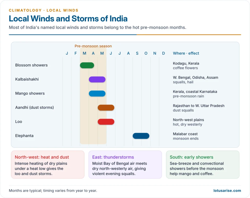
- Loo: a hot, dry, dusty westerly of the north-west plains, from Punjab and Rajasthan to Bihar, on May–June afternoons.
- At 45–50 °C it causes heatstroke; Churu recorded 50.5 °C on 28 May 2024. Since 2016, National Disaster Management Authority guidelines have shaped city and state heat action plans.
- Aandhi (dust storms): pre-monsoon squalls from thunderstorm downdrafts over Rajasthan, Punjab, Haryana and Uttar Pradesh; the storms of 2–3 May 2018, worst around Agra, killed over 120 people.
- Kalbaishakhi (nor’westers): evening thundersqualls from the north-west over West Bengal, Odisha, Assam (Bardoli chheerha) and Bangladesh.
- Hail and gusts cause damage, but the rain helps tea, jute and aus rice. Such storms spawned the Daulatpur–Saturia tornado (Bangladesh, 1989), which killed about 1,300 people.
- Mango showers (Kerala, coastal Karnataka) help mangoes ripen; blossom showers (Kodagu) bring coffee into flower.
- Elephanta: a strong southerly to south-easterly of the Malabar coast in September–October, marking the end of the south-west monsoon.
| Wind | Region | Season | Nature | Effect |
|---|---|---|---|---|
| Loo | North-west plains | May–June | Hot, dry westerly | Heatstroke, crop stress |
| Aandhi | Rajasthan to western Uttar Pradesh | May–June | Dust storm, squall | Damage, deaths, haze |
| Kalbaishakhi | West Bengal, Odisha, Assam | April–May | Thunderstorms with hail | Tea, jute, aus rice; damage |
| Mango showers | Kerala, coastal Karnataka | April–May | Pre-monsoon rain | Ripening of mangoes |
| Blossom showers | Kodagu, Kerala | March–April | Pre-monsoon rain | Coffee flowering |
Significance of Local Winds
- Air masses: many local winds are the local expression of air-mass movement:
- Sirocco, khamsin, harmattan and loo carry continental tropical (cT) air out of hot deserts.
- Mistral, bora, norther, pampero and blizzard bring continental polar (cP) or arctic air behind cold fronts or out of anticyclones.
- Föhn and chinook are maritime air transformed by passage over mountains.
- Weather and climate: sea breezes moderate coasts; föhn winds shorten winters; valley and sea breezes trigger daily showers; fall winds bring sudden cold.
- Agriculture: föhn and chinook open pastures; harmattan and loo desiccate crops; frost pockets decide orchard sites; pre-monsoon showers aid mango, coffee and tea.
- Hazards: heatstroke (loo), wildfires (Santa Ana, mistral), dust (sirocco, aandhi, harmattan) and wind damage (bora, kalbaishakhi).
- Local winds also carry or trap pollutants, affect aviation and small craft, and are tapped for wind energy.
Previous Year Questions
2025Explain the relationship between air masses and local winds.2023What are the causes of origin of local winds? Discuss their significance on prevailing weather and climate in various regions, with suitable examples.2014Discuss the salient features of ‘sirocco’ and ‘mistral’.2013With suitable examples, bring out the impact of local winds on the climate of an area.2007Discuss the development of local winds, and their influence on local weather, giving three examples of the well-known local winds in the world.




