

- The biogeography of climate change studies how a changing climate alters the distribution of species and ecosystems across geographic space.
- Every climate-driven range shift ends up as a practical problem for conservation: a reserve boundary drawn around yesterday’s habitat no longer contains today’s species.
- The altered distributions create specific conservation implications. These call for adaptive conservation strategies that differ from classical, place-based protection.
Conservation Implications of Climate-Induced Range Shifts

- Species are moving toward the poles or upslope as they track their preferred temperatures. The IPCC Sixth Assessment Report, Working Group II (2022), found that approximately half of the species assessed globally have already shifted.
- Range shifting is not new, but the speed and magnitude of the present shift are. This pace turns a natural process into a first-order conservation problem.
- Protected areas are losing their climates: only about 8% of the world’s protected areas are expected to keep their present climate within their boundaries for a century (Scott Loarie and colleagues, 2009).
- Three consequences follow.
Disruption of ecological networks
- An ecological network is the web of interactions between species (predation, competition, mutualism) that structures a functioning ecosystem.
- When species move into new territory faster than their historical neighbours, these networks are disrupted. At the extreme the existing ecosystem breaks down and a novel ecosystem takes its place: an assemblage of species that have never coexisted before.
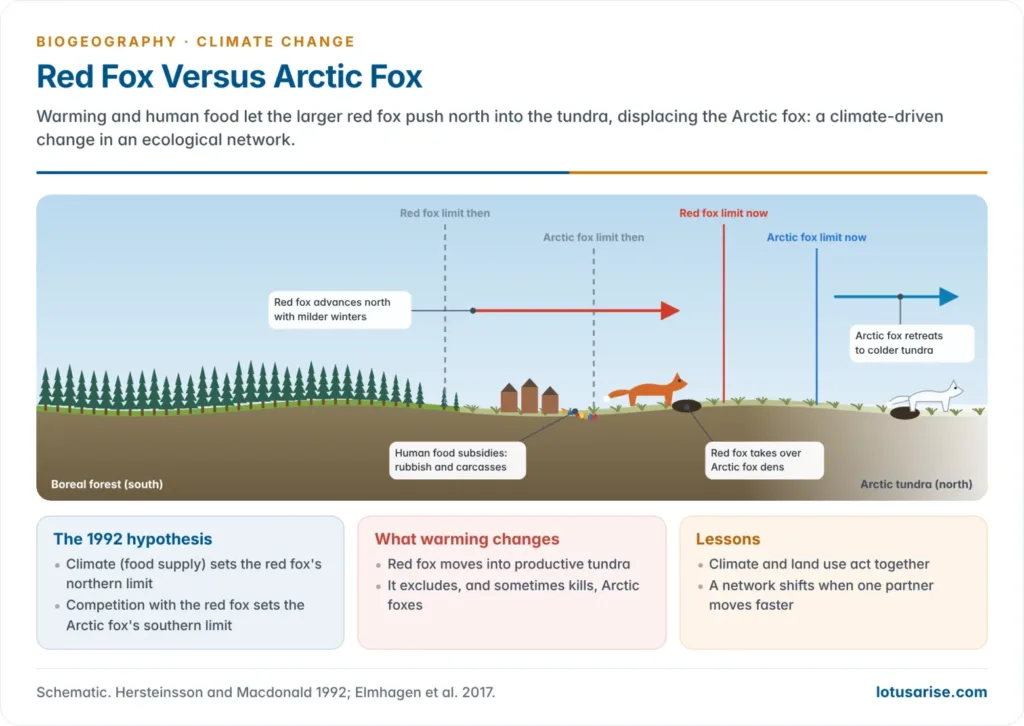
- Red fox and Arctic fox: Pall Hersteinsson and David Macdonald (1992) argued that climate sets the red fox’s northern limit, while competition with the red fox sets the Arctic fox’s southern limit.
- With warming, the larger red fox is advancing into productive tundra. It takes over Arctic fox dens and food and sometimes kills Arctic foxes, causing local declines and range contraction.
- Human food subsidies (rubbish, carcasses) let red foxes settle even north of their climatic limit, so climate and land use act together.
Loss of biodiversity
- Species that cannot move or adapt quickly enough face rising extinction risk, especially those with:
- narrow ecological niches;
- limited dispersal ability;
- ranges confined to isolated habitats such as mountaintops, islands and sky islands, with the least room left to retreat.
- The scale of risk (IPCC AR6, 2022):
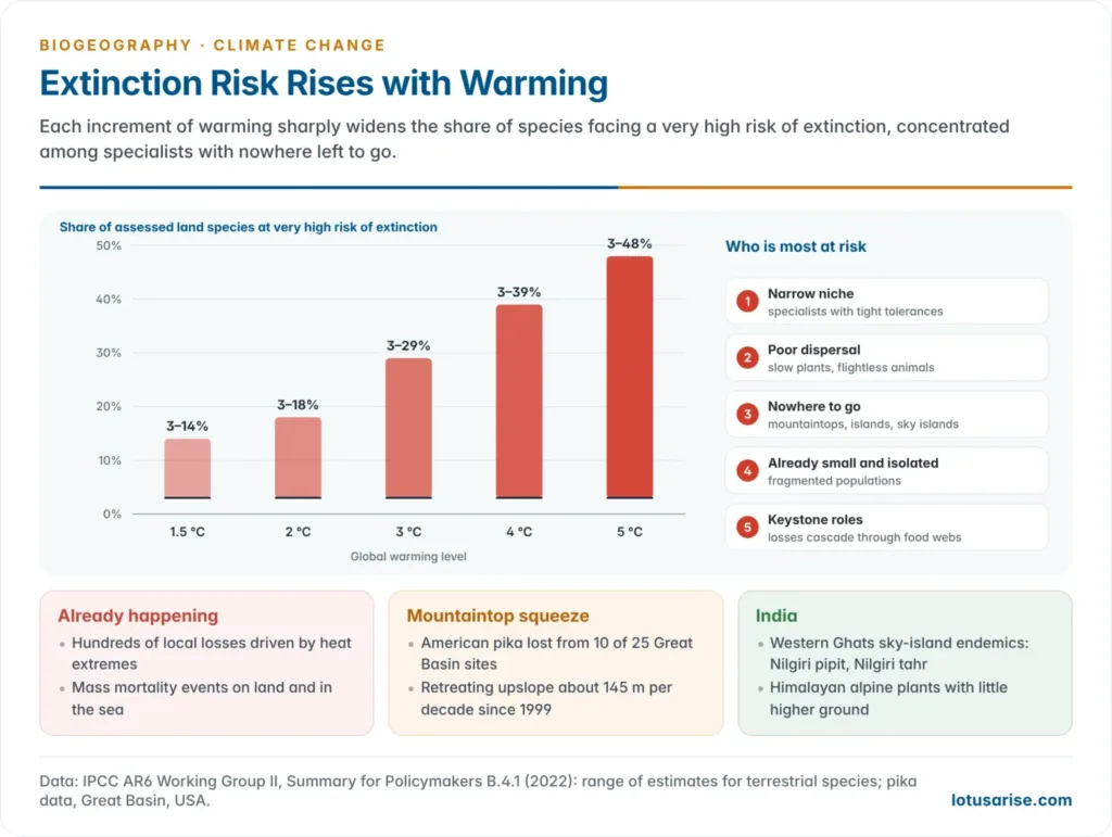
- “Hundreds of local losses of species” have already been driven by more intense heat extremes, with mass mortality events on land and in the sea.
- The share of assessed terrestrial species likely to face a very high risk of extinction rises with warming: 3–14% at 1.5 °C, 3–18% at 2 °C, 3–29% at 3 °C, 3–39% at 4 °C and 3–48% at 5 °C.
- The American pika of western North America shows the mountaintop squeeze:
- In the Great Basin, 10 of 25 sites with 20th-century records have lost their pikas.
- Since 1999 the species has retreated upslope about 145 m per decade.
- The first mammal extinction attributed to climate change, of the Bramble Cay melomys, shows the same end point of range contraction on a low island.
- Indian sky islands: the shola–grassland summits of the Western Ghats hold endemics such as the Nilgiri pipit and the Nilgiri tahr. Like Himalayan alpine plants, they have little higher ground to move to.
- Cascading effects: where a lost species plays a keystone role, its disappearance spreads through the ecosystem, altering vegetation structure, prey abundance or nutrient cycling.
Fragmentation and habitat loss
- Climate change does not act alone; it interacts with and worsens existing habitat fragmentation.
- As species try to move, they meet human barriers: roads, cities, farmland, dams and canals. These block passage to otherwise suitable habitat.
- Fragmentation reduces genetic diversity, limits adaptive capacity and raises the risk of local extinction (Nicole Heller and Erika Zavaleta, 2009).
- This is why habitat fragmentation, a classical theme of conservation biogeography linked to the species–area relationship and island biogeography theory, has become inseparable from climate biogeography.
- A fragmented landscape not only shrinks the area available today. It also blocks the route a species would use to reach its future range.
Adaptation Strategies for Conservation
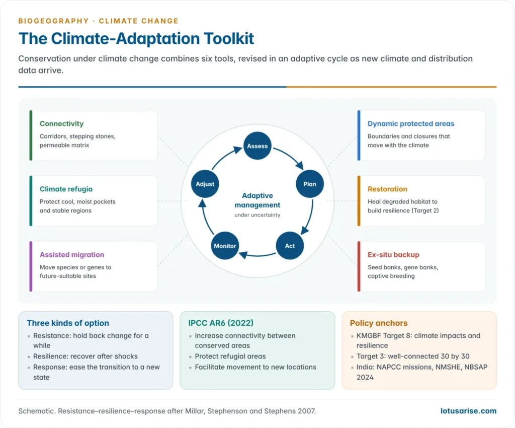
- Conservationists now pursue three goals: enhancing the resilience of ecosystems, facilitating species movement, and planning for future climates rather than present ones only.
- Constance Millar, Nathan Stephenson and Scott Stephens (2007) grouped the options into three kinds:
- resistance, which holds back change for a while;
- resilience, which helps systems recover after a shock;
- response (transition), which eases the change toward a new state.
- The IPCC AR6 lists the main ecological options:
- increasing connectivity between conserved areas;
- protecting refugial areas where species can survive locally;
- facilitating the movement of species to new, ecologically appropriate locations.
Enhancing ecological connectivity
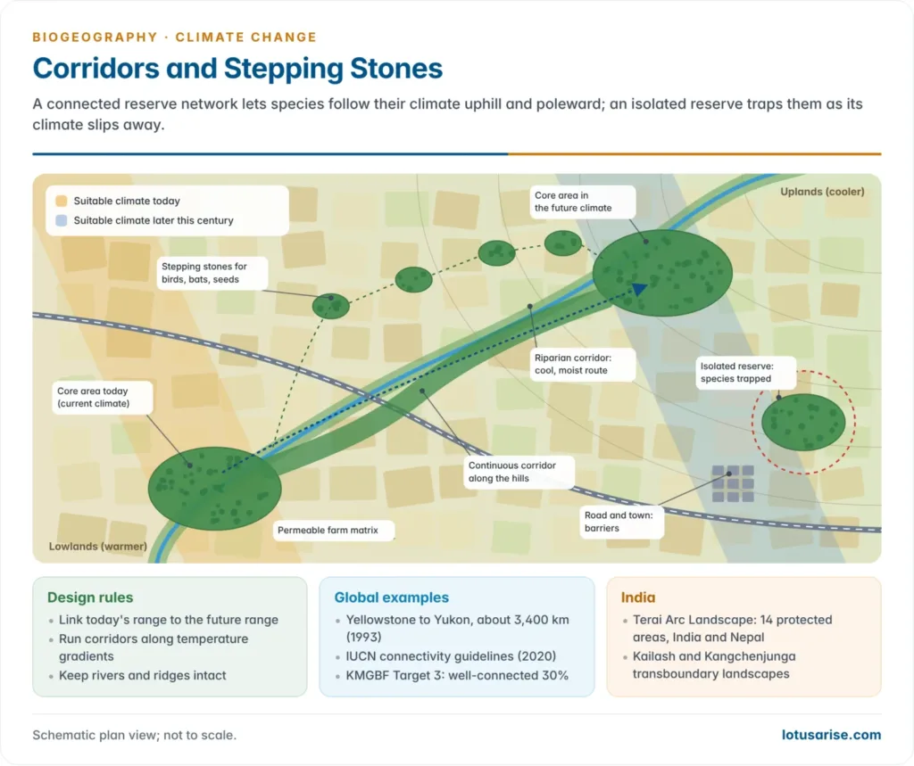
- Ecological connectivity is the ability of species to move across a landscape to track suitable habitat. It is achieved through ecological corridors and networks of protected areas that link fragmented patches.
- Forms of linkage:
- continuous corridors, such as river belts, forest strips and mountain ridges;
- stepping stones, small habitat patches that birds, bats and wind-dispersed plants can hop between;
- a permeable matrix of farmland, agroforestry and plantations that animals can cross.
- Climate-wise corridors run along temperature gradients, from lowland to highland or toward the pole, so they lead species to their future range. Riparian corridors add cool, moist routes.
- The IUCN guidelines on ecological networks and corridors (Jodi Hilty and colleagues, 2020) set the global standard. Target 3 of the Kunming–Montreal Global Biodiversity Framework asks that the 30% of land and sea to be conserved by 2030 be well connected.
- Examples:
- The Yellowstone to Yukon Conservation Initiative (1993) links protected areas along about 3,400 km of the Rocky Mountains.
- The Terai Arc Landscape joins 14 protected areas of India and Nepal between the Yamuna and the Bagmati rivers. Its corridors let tigers, elephants and rhinos cross the border.
- Transboundary Himalayan landscapes, such as the Kailash Sacred Landscape (India, China and Nepal) and the Kangchenjunga Landscape, keep long elevational gradients intact for upslope shifts.
Protecting climate refugia
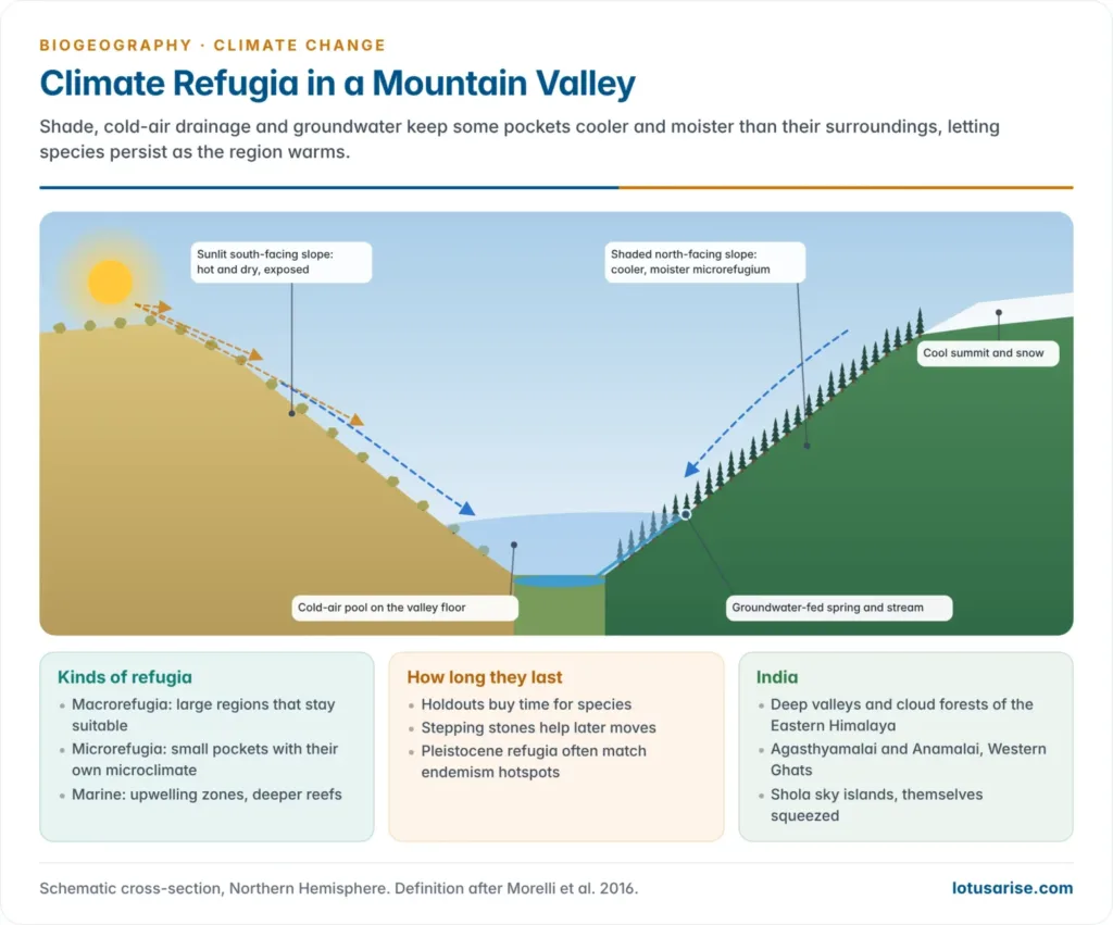
- Climate refugia are areas relatively buffered from contemporary climate change over time, which let valued physical, ecological and socio-cultural resources persist (Toni Lyn Morelli and colleagues, 2016). Protecting them is now a stand-alone adaptation strategy.
- Macrorefugia are large regions that stay suitable. Microrefugia are small pockets with their own microclimate.
- What creates refugia:
- topographic shade: north-facing slopes in the Northern Hemisphere, deep gorges and ravines;
- cold-air pooling in valley bottoms and frost hollows;
- groundwater-fed springs, streams and wetlands;
- the buffering effect of large lakes and the sea;
- cool upwelling water and deeper reefs in the ocean.
- The Pleistocene refugia of the glacial cold often coincide with today’s centres of endemism and genetic diversity.
- Indian examples:
- the cool, moist deep valleys of the Eastern Himalaya and its cloud forests;
- the high, wet southern blocks of the Western Ghats (Agasthyamalai and Anamalai);
- the sky islands of the Western Ghats, which are cool refuges today but may themselves be squeezed.
- Refugia are not permanent. Some act as holdouts, buying time for species, while others serve as stepping stones for later moves.
Assisted migration
- Where barriers block natural migration, or where climate change outpaces a species’ own dispersal, conservationists consider assisted migration. It is the deliberate, human-mediated relocation of a species to a new area where the future climate is projected to suit it.
- Related terms:
- The IUCN Guidelines for Reintroductions and Other Conservation Translocations (2013) call a move outside the native range assisted colonisation; the term managed relocation is also used.
- Assisted gene flow moves heat-adapted individuals or seed within a species’ range.
- Examples:
- Torreya taxifolia, an endangered conifer of the Apalachicola ravines (Florida, Georgia): in July 2008 a citizen group, the Torreya Guardians, planted 31 seedlings in North Carolina. Critics note that a fungal disease, not climate, caused its decline; the case anchors the debate reviewed by Mark Schwartz and colleagues (2012).
- Marbled white and small skipper butterflies were moved in 2000 to sites in northern England beyond their range. They thrived, showing that species lag behind climate and that translocation can work.
- Western swamp tortoise: in 2016, 24 captive-bred animals were released south of its native swamps near Perth. It was the first vertebrate moved outside its historic range because of climate projections.
- The debate:
- For: it offers a genuine lifeline to species that cannot disperse fast enough on their own, and humans arguably owe help to species threatened by human-caused change.
- Against: the newcomer may turn invasive, carry disease or hybridise with residents, and our ability to predict outcomes is limited.
- Middle path: Ove Hoegh-Guldberg and colleagues (2008) proposed a decision framework. It weighs extinction risk, the feasibility of moving the species and the risk to the recipient ecosystem, and calls for long-term monitoring.
Dynamic conservation planning
- Because both future climate and species responses are uncertain, practice is shifting to dynamic conservation planning: a flexible approach adjusted as new information arrives, rather than a one-time, fixed reserve design.
- In practice, climate models and species distribution models identify areas likely to stay suitable under a range of future scenarios. Planners then prioritise exactly those areas, so today’s investment keeps paying off as the climate shifts (Edward Game and colleagues, 2011).
- Adaptive management closes the loop: assess, plan, act, monitor, then adjust priorities as new climate and distribution data arrive.
- Dynamic protected areas move or change in time:
- dynamic ocean management, such as NOAA’s TurtleWatch maps, which steer fishing away from the moving band of water temperature that loggerhead turtles follow;
- buffer zones and future-range sites can be added to a reserve network as species move.
- Conserving nature’s stage: species move but landforms and soils endure, so planners protect the full variety of geophysical settings (elevation, aspect, rock type) on which future communities will assemble.
Ex-situ backup
- When habitats may vanish faster than species can move, ex-situ conservation keeps living material as insurance:
- seed banks, such as the Svalbard Global Seed Vault (2008) and India’s National Genebank at the ICAR–National Bureau of Plant Genetic Resources;
- botanical gardens, zoos and captive breeding, such as the Perth Zoo tortoises above;
- cryopreserved tissue, pollen and gametes.
- India’s Chang La seed vault in Ladakh (2010), at about 5,300 m, uses natural cold to back up the national gene banks.
| Strategy | Core mechanism | Representative example |
|---|---|---|
| Ecological connectivity | Corridors and linked protected-area networks enabling movement between habitat patches | Yellowstone to Yukon Initiative; Terai Arc Landscape (India and Nepal) |
| Climate refugia protection | Identifying and shielding climatically stable pockets from development | Mountain microhabitats; Himalayan cloud forests; Western Ghats sky islands |
| Assisted migration | Deliberate relocation beyond the current range to a future-suitable site | Torreya taxifolia in North Carolina (2008); western swamp tortoise (2016) |
| Dynamic conservation planning | Flexible, model-driven priorities revised as new data arrive | Multi-scenario protected-area prioritisation (Game et al., 2011); dynamic ocean management |
| Ex-situ backup | Seeds, tissues and captive populations held off-site | Svalbard Global Seed Vault; Chang La vault, Ladakh |
Policy Frameworks
IPCC AR6 Working Group II (2022)
- Because extinction risk climbs with each increment of warming, mitigation is itself a conservation measure.
- Maintaining the resilience of biodiversity depends on effectively and equitably conserving about 30–50% of Earth’s land, freshwater and ocean areas.
Kunming–Montreal Global Biodiversity Framework (2022)
- Target 8: “Minimize the impact of climate change and ocean acidification on biodiversity and increase its resilience through mitigation, adaptation, and disaster risk reduction actions, including through nature-based solutions and/or ecosystem-based approaches, while minimizing negative and fostering positive impacts of climate action on biodiversity.”
- Target 3 (30 by 30) asks for well-connected protected areas, and Target 2 for restoring 30% of degraded ecosystems. Both widen the space species need to move.
- COP17, in Yerevan, Armenia (19–30 October 2026), is holding the first global review of progress. Its draft report finds implementation too slow to meet the targets by 2030.
India’s response
- The National Action Plan on Climate Change (2008) set up eight national missions. Two bear directly on biogeography:
- The National Mission for Sustaining the Himalayan Ecosystem (NMSHE), launched in 2014 under the Department of Science and Technology. It assesses the health of the Himalayan ecosystem (glaciers, biodiversity, climate) and supports State Climate Change Cells in 13 Himalayan states and Union territories.
- The Green India Mission (2014), which restores and expands forest cover.
- India’s updated National Biodiversity Strategy and Action Plan, released at COP16 in October 2024, adopts 23 national targets mirroring the global framework, including protecting 30% of land and sea.
- Many of India’s biodiversity conservation measures now carry a climate lens.
Challenges and Future Directions
- These strategies are promising, but none is a complete solution. Three constraints recur:
- Uncertainty in climate projections: models show the broad direction of change but rarely pin down local outcomes.
- Limited resources and competing land use: corridors, refugia and monitoring compete for money and land with agriculture, infrastructure and cities.
- The pace of climate change itself: at worst it may outstrip what species and ecosystems can adapt to, causing irreversible biodiversity loss whatever strategy is used.
- The way forward needs sustained investment in refining climate models, continuously monitoring species distributions and developing new conservation techniques. These must rest on close collaboration between scientists, policymakers and local communities, without which even sound strategies fail in implementation.




