UPSC Geography Optional Question Paper 2025

Exam Date: Both Geography Optional Papers (Paper I & II) were conducted on 31 August 2025 —Paper I in the morning (9:00–12:00) and Paper II in the afternoon (2:30–5:30)
Marks & Duration: Each paper carries 250 marks with a duration of 3 hours, totalling 500 marks for the optional subject.
Every question on this page, already answered
Reading a past paper tells you what UPSC asked. It does not tell you what a 300-plus answer to it looks like — and that is the part that decides your marks. The Geography Optional 300+ Score Pack carries a written model answer for every question the Commission has set since 2013, including every question on this 2025 paper.
- 820 solved PYQ model answers (2013–2026) — topic-wise across all 20 units, Paper I and Paper II
- 20 PYQ pattern & strategy reports — one per unit: what repeats, what is due, what UPSC rewards
- Diagrams and maps drawn inside the answers, at the exact point where you would draw them in the exam hall
- 500 days of access from your enrolment date — covered right through Mains 2027
₹1,770 (regular ₹2,500) — about ₹2.16 per model answer. One-time payment, no subscription.
Geography Optional Question Paper-1 (2025)
Section: A
1.
निम्नलिखित में से प्रत्येक का उत्तर लगभग 150 शब्दों में दीजिए :
Answer the following in about 150 words each : 10×5=50
(a) हिमानी झील विस्फोट के बाद के बाढ़ की व्याख्या कीजिए।
Explain the causes of glacial lake outburst flood.
(b) सोलिफ्लक्शन क्या है? इसके प्रभाव क्या हैं?
What is solifluction? What are its impacts?
(c) नप्पेस पट्टियों में भूगर्भीय तथा ओरोजेनिक पट्टियों में अपक्षय भूगर्भीय तथा विवर्तनिक प्रक्रियाएँ क्या हैं?
What geological and tectonic processes lead to the formation of nappes in orogenic belts?
(d) वायुस्त्रोतों एवं स्थानीय पवनों का संबंध समझाइए।
Explain the relationship between air masses and local winds.
(e) समुद्र तरंग, समुद्र धाराएँ एवं ज्वार-भाटा में मौलिक अंतर क्या है?
What are the fundamental differences among ocean wave, ocean current and tide?
2. (a) अपक्षय एवं स्वाभाविकी की क्रमिक घटनाओं को समझने में अपक्षय एवं स्वाभाविकी विज्ञान का क्या महत्व है? यह स्पष्ट कीजिए।
How does denudation chronology help in understanding the sequential development of landscapes and landforms? Elucidate. 20
(b) गहरे समुद्र की खनन क्या है? इसके संबंधित लाभ तथा जोखिम क्या हैं?
What is deep-sea mining? What are the potential benefits and risks associated with it? 20
(c) मनुष्य एवं वन्यजीव संघर्ष निरंतर बढ़ रहे हैं। इसके कारण, परिणाम एवं निवारण पर चर्चा कीजिए।
Man and wildlife conflicts are ever increasing. Discuss its causes, consequences and remedial measures. 10
3. (a) वायुमंडलीय त्रिवलयी परिसंचरण प्रणाली के निर्माण की विवेचना कीजिए। यह कैसे पृथ्वी के गोलाकार आकार के कारण उत्पन्न होती है?
Examine the formation of atmospheric tricellular circulation system. Describe how this system has been created considering the Earth a living planet. 20
(b) ‘संयुक्त राष्ट्र पारिस्थितिकी तंत्र दशक’ की समीक्षा कीजिए। यह उभरते सामाजिक-आर्थिक मुद्दों जैसे खाद्य सुरक्षा और विकास की आवश्यकता को कैसे संतुलित करता है?
What is the ‘UN Decade on Ecosystem Restoration’? How does it balance ecological goals with emerging socio-economic needs like food security and development? 15
(c) ‘हिमालय अभी भी ऊपर उठ रहा है।’ उपयुक्त चित्रों एवं आरेखों के माध्यम से इस कथन का विस्तार कीजिए तथा इसमें सम्मिलित प्रमुख प्रक्रियाओं का वर्णन कीजिए।
“The Himalaya is still rising.” Expand this statement and describe the processes involved in it with suitable sketches and diagrams. 15
4. (a) अमेज़न एवं कॉंगो बेसिन में कृषि वनों की कटाई के पारिस्थितिक परिणामों की विवेचना कीजिए, विशेष रूप से जैव विविधता एवं जलवायु नियंत्रण प्रणाली को ध्यान में रखते हुए।
What are the ecological consequences of agricultural deforestation in the Amazon and Congo Basins, particularly concerning biodiversity and climate regulation? 20
(b) पृथ्वी की वायुमंडल प्रणाली में ऊर्जा के वितरण एवं संतुलन का परीक्षण कीजिए।
Examine the distribution and balance of energy in the Earth’s atmosphere system. 15
(c) अवरोध द्वीपों की निर्माण प्रक्रिया का वर्णन कीजिए, तथा इनके महत्व का व्याख्यान कीजिए।
Describe the process of formation of barrier islands and explain their significance. 15
Section: B
5. निम्नलिखित में से प्रत्येक का उत्तर लगभग 150 शब्दों में दीजिए :
Answer the following in about 150 words each : 10×5=50
(a) मानव भूगोल में कल्याणकारी दृष्टिकोण 1970 के दशक में एक महत्वपूर्ण दृष्टिकोण के रूप में क्यों उभरा?
Why did the Welfare Approach in Human Geography emerge as a significant perspective in 1970s?
(b) खनिजीय (क्रिटिकल) खनिजों की निकासी एवं प्रसंस्करण से जुड़ी प्रमुख पर्यावरणीय एवं आर्थिक चुनौतियाँ क्या हैं?
What are the key environmental and economic challenges linked to the extraction and processing of critical minerals?
(c) आंतरिक प्रवासन के कारक अक्सर ‘वास्तविकता की अपेक्षा धारणाओं’ पर आधारित होते हैं। स्पष्ट कीजिए।
Factors in internal migration are often based on perceptions rather than reality. Explain.
(d) ‘क्षेत्रीय असमानताएँ विभिन्न क्षेत्रों के सामाजिक-आर्थिक कारकों का परिणाम हैं।’ स्पष्ट कीजिए।
‘Regional imbalances are the product of socio-economic factors.’ Elucidate with examples.
(e) शहरी नियोजन में प्रणाली विश्लेषण दृष्टिकोण का महत्व समझाइए।
Why is systems analysis important in urban planning and what are its limitations?
6. (a) विभाजनवाद एवं द्वैतवाद ने भूगोल के पद्धतिगत विकास को कैसे प्रभावित किया? वर्णन कीजिए।
How have dichotomy and dualism affected the methodological development of Geography? Describe. 20
(b) भाषा एवं धर्म मुख्य सांस्कृतिक प्रदेशों के परिसीमन में भाषा एवं धर्म की भूमिका का विवेचन कीजिए।
Analyze the role of language and religion in delineating major cultural regions of the world. 15
(c) उष्णकटिबंधीय एवं उपोष्णकटिबंधीय क्षेत्रों में वाणिज्यिक फसलों के स्थानिक प्रतिरूप एवं प्रादेशिक विशेषता का विवेचन कीजिए।
Analyze the spatial patterns and regional specialization of plantation crops across tropical and subtropical regions. 15
7. (a) तेल, ऊर्जा सुरक्षा के लिए क्यों महत्वपूर्ण है? स्वच्छ ऊर्जा संक्रमण में तेल की क्या भूमिका है?
Why is oil important for energy security? What is the role of oil in clean energy transition? 20
(b)विकासशील देशों में प्राइमेट शहरों के शहरी क्षेत्र (प्राइमेट सिटी) के वर्चस्व का समाजशास्त्रीय मूल्यांकन कीजिए।
Critically evaluate the role of primate cities in dominating the urban spheres of influence in developing countries. 15
(c) “वैश्विक जनसांख्यिकीय परिदृश्य कुछ स्थानों पर तीव्र जनसंख्या वृद्धि और अन्य स्थानों पर तीव्र वृद्धावस्था के साथ विकसित हो रहा है।” उदाहरण सहित स्पष्ट कीजिए।
“The global demographic landscape is evolving with rapid population growth in some places and rapid ageing in others.” Elucidate with examples. 15
8. (a) पेरूक्स की विकास ध्रुव सिद्धान्त एक क्षेत्र के विकास का मॉडल रहा है परन्तु इस सिद्धान्त की आलोचना क्यों हुई? उदाहरणों के साथ स्पष्ट कीजिए।
Why has P. Perroux’s theory of growth pole as a model of regional growth been criticized? Explain with examples. 20
(b) जनांकिकीय संक्रमण सिद्धान्त की व्याख्या कीजिए तथा जनसंख्या विविधताओं को समझने में इसकी भूमिका का विवेचन कीजिए।
Analyze the role of demographic transition theory in explaining variations in fertility and mortality rates globally. 15
(c) प्रादेशिक घटक क्षेत्रीय संश्लेषण को स्थानिक व्यवस्था में कैसे उत्पन्न करते हैं? व्याख्या कीजिए।
How do regional components make the (regional synthesis) in spatial arrangement? Explain. 15
Could you actually write these answers — in 20 minutes each?
That is the honest test of a past paper, and it is where Paper I marks are lost. Not in knowing plate tectonics or the tricellular circulation, but in structuring the answer, placing the right labelled diagram at the right point, and finishing inside the time available. The 300+ Score Pack gives you the written form of each of these 2025 answers, so you are studying a structure instead of inventing one under pressure.
Paper II is reproduced below. Before you scroll on, mark the three questions above you could not attempt today — those are the ones to read the model answers for first.
Geography Optional Question Paper-2 (2025)
Section: A
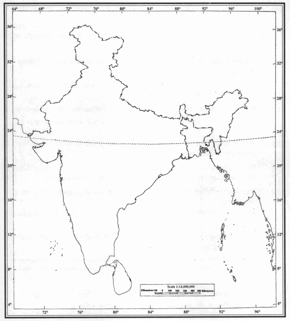
1.(a) आपको दिए गए भारत के मानचित्र पर, निम्नलिखित सभी स्थलों की स्थिति को अंकित कीजिए।
अपने QCA पुस्तिका में इन स्थानों में से प्रत्येक का भौतिक / वाणिज्यिक / आर्थिक / पारिस्थितिकीय / पर्यावरणीय / सांस्कृतिक महत्व अधिकतम 30 शब्दों में लिखिए।
On the outline map of India provided to you, mark the location of all of the following. Write in your QCA Booklet the significance of these locations, whether physical / commercial / economic / ecological / environmental / cultural, in not more than 30 words for each entry : 2×10=20
(i) रुशिकुल्या नदी
Rushikulya River
(ii) दातार हिल
Datar Hill
(iii) किकरुमा
Kikruma
(iv) चोरतनद तिल्लाया
Chortanid Tillaya
(v) ब्यालालु
Byalalu
(vi) नेय्यर
Neyyar
(vii) उत्तरलाई
Uttarlai
(viii) श्री विजयपुरम्
Sri Vijayapuram
(ix) धारवास
Dharwas
(x) गीताबिटान
Gitabitan
1.(b) केरेवों के स्थान और भौतिक निर्माण का उल्लेख करते हुए, उनके आर्थिक महत्व को रेखांकित कीजिए।
Referring to the location and physical formation of karewas, highlight their economic significance. 10
1.(c) हिमालयी पारिस्थितिकी तंत्र भारत के हिमालयी क्षेत्र में फसल प्रणाली और कृषि गतिविधियों को कैसे नियंत्रित करता है? चर्चा कीजिए।
How does Himalayan ecosystem regulate the cropping pattern and agricultural activities in Himalayan region of India? Discuss. 10
1.(d)
भारत में नौकायन पर्यटन और इसके बुनियादी ढांचे पर एक आलोचनात्मक तर्कसंगत निबंध लिखिए।
Write a critically argued essay on nautical tourism and its infrastructure in India. 10
2.(a) भारत के औषधीय उद्योग के विकास में योगदान करने वाले कारकों की व्याख्या कीजिए: भारत के पश्चिम क्षेत्र में इसके संकेन्द्रण के संदर्भ में टिप्पणी कीजिए।
Explain the factors which contribute to the growth of India’s pharmaceutical industry with specific reference to its concentration in western region of India. 20
2.(b) भारत में प्रवाल भित्तियां अपने पारिस्थितिकीय तंत्र के संदर्भ में सबसे महत्वपूर्ण क्यों हैं? अन्वेषण कीजिए।
Why are coral reefs in India most important with respect to its dynamic ecosystem? Explore. 15
2.(c) भारत का कृषि क्षेत्र किस प्रकार से देश के विभिन्न क्षेत्रों में समकालीन भौतिक और राजनीतिक-आर्थिक परिवर्तनों का सामना करता है? स्पष्ट कीजिए।
How does the agricultural sector of India confront with the contemporary physical and politico-economic changes in the different regions of the country? Elucidate. 15
3.(a) भारत में अनुसूचित जातियों व अनुसूचित जनजातियों के जनसंख्या वितरण का प्रतिरूप भिन्न क्यों है? उनके सामाजिक-आर्थिक समस्याओं को उदाहरण सहित स्पष्ट कीजिए।
Why is the pattern of population distribution of scheduled castes and scheduled tribes different in India? Compare their socio-economic problems with examples. 15
3.(b) भारत के पूर्वी घाट की भौ-उपयोग की विशेषताओं को विवेचित कीजिए। क्षेत्र में भौ-उपयोग की समस्याओं का विवेचन कीजिए।
Highlight the characteristics of land utilization in Eastern Ghats region of India. What are the land utilization problems in the region? 15
3.(c) भारत में डेयरी क्षेत्र की चुनौतियां क्या हैं? गौवंशीय उत्पादकता के योगदान का वर्णन कीजिए।
What are the challenges of dairy sector in India? Describe the contribution of bovine population. 15
4.(a)
“भारत का सामाजिक-राजनीतिक परिदृश्य क्षेत्रीय चेतना का परिणाम है जो अंतर-राज्य विवाद पैदा करता है।” क्षेत्र विशेष उदाहरणों के साथ चर्चा कीजिए।
“Socio-political landscape in India is a result of regional consciousness creating inter-state disputes.” Discuss with region specific examples.
20
4.(b) भारत में कुटीर उद्योग भारतीय सामाजिक-आर्थिक संरचना का अभिन्न अंग क्यों हैं? ग्रामीण भारत में विभिन्न प्रकार के कुटीर उद्योगों के संदर्भ में इसका आकलन कीजिए।
Why cottage industries in India are an integral part of Indian socio-economic structure? Assess this with reference to different types of cottage industries in rural India. 15
4.(c) “भारत के ग्रामीण बस्तियां भौतिक और सांस्कृतिक दोनों कारकों के कारण अत्यधिक विविधता लिए हैं।” उदाहरण सहित कथन की पुष्टि कीजिए।
“The rural settlements in India are highly diversified due to both physical and cultural factors.” Justify the statement with examples. 15
Section: B
5.(a) ग्रामीण-नगरीय उपान्त को कैसे निरूपित किया जा सकता है? भारत के उपयुक्त उदाहरणों सहित व्याख्या कीजिए।
How can rural-urban fringe be delineated? Explain with suitable examples from India.
10
5.(b)
“भारत में धार्मिक समूहों का स्थानिक वितरण कोई विशिष्ट प्रतिरूप नहीं दर्शाता है।” तर्कपूर्ण उदाहरण सहित व्याख्या कीजिए।
“Spatial distribution of religious groups in India does not show any specific pattern.” Illustrate with arguments. 10
5.(c)
जलागम के लिए जलविभाजक रेखा (वाटरशेड) सबसे उपयुक्त स्थानिक इकाई है। टिप्पणी कीजिए।
“Watershed is the most appropriate spatial unit for planning.” Comment. 10
5.(d) क्या पूर्वोत्तर भारत एक भू-राजनीतिक या भू-सांस्कृतिक क्षेत्र है? अपने उत्तर की पुष्टि कीजिए।
Is North East India a geo-political or geo-cultural region? Justify your answer. 10
5.(e) सजाना की खेती के लिए आवश्यक परिस्थितियों की चर्चा कीजिए तथा भारत में इसके उत्पादन क्षेत्रों का वर्णन कीजिए।
Discuss the necessary conditions for the cultivation of fox nuts and describe the areas of its production in India. 10
6.(a) ‘अर्बन हीट आइलैंड’ की परिघटना के कारणों का वर्णन कीजिए। भारत में इस परिघटना से निपटने के लिए प्रभावी उपाय क्या हैं?
Describe the causes of the phenomenon of ‘urban heat island’. What are the effective measures to deal with this phenomenon in India? 20
6.(b) भारत की परिवहन और संचार तंत्र प्रणाली के संदर्भ में सागरमाला परियोजना की समीक्षात्मक विवेचना कीजिए।
With reference to the transport and communication network of India, critically discuss the ‘Sagarmala project’. 15
6.(c) भारत में जनसंख्या के लिंग-अनुपात की प्रमुख विशेषताएं क्या हैं? देश में सामान्य लिंग अनुपात पर बाल-लिंग अनुपात के प्रभावों का मूल्यांकन कीजिए।
What are the key features of sex-ratio of population in India? Evaluate the impacts of child sex-ratio on general sex-ratio in the country. 15
7.(a) खाद्य उत्पादन, वितरण और उपलब्धता के विशेष सन्दर्भ में भारत के सूखे में योगदान करने वाले कारकों की व्याख्या कीजिए। क्या भारतीय कृषि नीतियाँ इस मुद्दे को सुलझा सकती हैं?
Explain the factors that contribute to droughts in India with specific reference to food production, distribution and availability. Can Indian agricultural policies resolve the issue? 20
7.(b) भारत में मरुस्थलीकरण होने तथा भूमि-क्षरण के क्या कारण और प्रभाव हैं? विभिन्न क्षेत्रीय मुद्दों के सन्दर्भ में जांच कीजिए।
What are the causes and consequences of land degradation due to desertification in India? Examine with reference to various regional issues. 15
7.(c) भारत के नीली अर्थव्यवस्था में कदम बढ़ाने के पहल की वैधता की जांच कीजिए। देश के विकास में इस अर्थव्यवस्था के प्रभावों की विस्तार से व्याख्या कीजिए।
Examine the validity of Blue Economy initiatives of India. Elaborate the impacts of this economy on country’s development. 15
8.(a) ‘ग्रीन आर्किटेक्चर’ को परिभाषित करते हुए, भारत में जलवायु परिवर्तन के प्रत्युत्तर में इसके सिद्धान्तों और चुनौतियों को स्पष्ट कीजिए।
While defining the ‘Green architecture’, discuss its principles and challenges in response to climate change in India. 20
8.(b) विशेष उदाहरणों सहित, यह आकलन कीजिए कि भारत में प्रादेशिक नियोजन द्वीपीय प्रदेशों के सतत विकास के लिए क्यों महत्वपूर्ण है।
With reference to typical examples, assess why regional planning in India is important for island territories for their sustainable development. 15
8.(c) भारत की अंतर्राष्ट्रीय सीमाओं के सन्दर्भ में, संबंधित मुद्दों पर चर्चा करते हुए उपयुक्त उदाहरण दीजिए।
With reference to international boundaries of India, discuss the related issues, giving suitable examples. 15
UPSC Geography Optional Question Paper 2025 – Analysis & Perspective
The UPSC Geography Optional Question Paper 2025 once again highlighted the commission’s evolving trend of testing conceptual clarity, application orientation, and contemporary linkages. Both Paper I (Physical Geography) and Paper II (Human & Indian Geography) were balanced but demanded multi-dimensional answers with diagrams, maps, and case studies.
Paper I – Physical Geography (Analysis)
- Balanced Coverage
- Questions spanned across Geomorphology, Climatology, Oceanography, Biogeography, and Models & Theories.
- Equal weightage to fundamental concepts (landform development, atmospheric circulation) and analytical applications (impact of climate change, role of human agency in geomorphic processes).
- Trend Observed
- Shift toward interlinking natural processes with human impact.
- Emphasis on contemporary scientific issues like glacial retreat, ocean currents & El Niño, biodiversity loss.
- Difficulty Level
- Moderate to difficult: Direct questions on landform theories were manageable, but applied questions (e.g., disaster-related geomorphology, urban climatology) tested depth.
- Answering Strategy Needed
- Diagrams: Block diagrams, climatic charts, ocean current maps were essential.
- Integration of Current Affairs: Linking IPCC reports, UN biodiversity reports, or Indian monsoon studies would add value.
Paper II – Human & Indian Geography (Analysis)
- Contemporary Orientation
- Questions focused heavily on urbanization, regional planning, agriculture, resource geography, and environmental issues.
- Integration of policy perspective (e.g., Smart Cities Mission, NITI Aayog on sustainable development, National Disaster Management Authority).
- Map-Based Questions
- Consistent weightage (~20–30%). Required identification of places, resources, and contemporary developments.
- Trend Observed
- Increasing focus on disaster geography & environment: floods, droughts, urban heat islands.
- Demand for case study-based answers: Aspirants had to cite Indian examples (e.g., Mumbai floods, Joshimath subsidence, India’s renewable energy hubs).
- Difficulty Level
- Paper II was relatively more analytical, requiring linkages between theories & real-world examples.
- Questions tested clarity of concepts + ability to write policy-relevant, India-specific answers.
Overall Perspective
- Paper Balance:
- Paper I leaned toward scientific fundamentals + environment issues.
- Paper II emphasized policy application + Indian case studies.
- Recurring Themes: Climate change, resource sustainability, regional planning, urbanization, disaster management.
- Answer Writing Expectation:
- Maps/diagrams in at least 70–80% of answers.
- Application of theories + contemporary case studies.
- Multi-dimensional approach: physical, social, economic, and policy perspectives.
Comparison with Previous Years
- More Analytical: Compared to 2023–24, 2025 papers had fewer rote-memory questions, more “think & apply” questions.
- Current Affairs Integration: Geography is increasingly overlapping with GS topics—climate policy, SDGs, urban issues.
- High Scoring Potential: Students who practiced diagrammatic representation + PYQ trend analysis were at an advantage.
Key Takeaways for Aspirants
- Paper I Preparation
- Master fundamentals (geomorphology, climatology) but prepare to link with climate change, disasters, human impact.
- Practice diagrams daily.
- Paper II Preparation
- Focus on Indian case studies & government reports (NITI Aayog, MoEFCC, IPCC, UN-Habitat).
- Prepare map-based notes for regions, resources, disasters.
- General Strategy
- Don’t study Geography in isolation—integrate with current affairs & GS topics.
- Prioritize answer writing practice with PYQs under time-bound conditions.
- Use a holistic, interlinked approach—as UPSC is testing geography as an applied discipline.
✨ Perspective for Future Aspirants
The 2025 Geography Optional Papers reaffirm a clear message from UPSC:
- Geography is no longer just about “descriptive knowledge.”
- It’s about concept clarity + application + contemporary awareness.
- Those who treat it as a living subject—with maps, diagrams, case studies, and report-based analysis—will continue to score 300+ marks.
Two ways to prepare for the papers above
Past papers are the syllabus UPSC actually examines. What you do next with them decides the marks. Two LotusArise systems are built for the two different gaps aspirants have at this stage.
| 300+ Score Pack | Mains Master Kit 2027 | |
| Best for | You already have notes and your gap is answer writing | You are starting Geography Optional and want one complete system |
| Core content | 820 solved PYQ model answers (2013–2026), topic-wise across all 20 units | Complete Notes PDF for Paper I & II — 3,000+ pages covering the full syllabus |
| Also inside | 20 unit-wise PYQ pattern & strategy reports; diagrams and maps inside the answers | Topic-wise test series questions for both papers; 12 months premium article access; 500+ mapped locations |
| Access | 500 days from enrolment | 12 months, all devices, offline |
| Price | ₹1,770 (regular ₹2,500) | ₹1,770 (regular ₹5,000) |
Both are one-time payments with instant access and no subscription. If you are unsure, start with the 300+ Score Pack — answer writing is the constraint for most aspirants who have already read the syllabus once.
Geography Optional Question Paper 2025 — FAQs
Geography Optional question papers — other years
- UPSC Geography Optional Question Paper 2013
- UPSC Geography Optional Question Paper 2014
- UPSC Geography Optional Question Paper 2015
- UPSC Geography Optional Question Paper 2016
- UPSC Geography Optional Question Paper 2017
- UPSC Geography Optional Question Paper 2018
- UPSC Geography Optional Question Paper 2019
- UPSC Geography Optional Question Paper 2020
- UPSC Geography Optional Question Paper 2021
- UPSC Geography Optional Question Paper 2022
- UPSC Geography Optional Question Paper 2023
- UPSC Geography Optional Question Paper 2024
- UPSC Geography Optional Question Paper 2026
- Geography Optional question papers — topic-wise PYQ hub
- Geography Optional 300+ Score Pack — solved PYQ model answers (2013–2026)