The Geography Optional Question Paper 2024 was set for UPSC Civil Services Mains 2024. Paper I and Paper II carry 250 marks each, three hours each, 500 marks together. Both papers are reproduced below exactly as UPSC asked them, followed by a unit-wise breakdown of what the paper tested, what the 2024 pattern tells you about how the Commission frames questions, and how to work through these questions instead of only reading them.
| Examination | UPSC Civil Services Mains 2024 — Geography Optional |
| Papers | Paper I (Physical & Human Geography) and Paper II (Geography of India) |
| Marks | 250 per paper — 500 total |
| Duration | 3 hours per paper |
| Structure | Section A and Section B, four questions each. Q1 and Q5 are compulsory; one question from the remaining three in each section. |
| Language | English and Hindi |
Every question on this page, already answered
Reading a past paper tells you what UPSC asked. It does not tell you what a 300-plus answer to it looks like — and that is the part that decides your marks. The Geography Optional 300+ Score Pack carries a written model answer for every question the Commission has set since 2013, including every question on this 2024 paper.
- 820 solved PYQ model answers (2013–2026) — topic-wise across all 20 units, Paper I and Paper II
- 20 PYQ pattern & strategy reports — one per unit: what repeats, what is due, what UPSC rewards
- Diagrams and maps drawn inside the answers, at the exact point where you would draw them in the exam hall
- 500 days of access from your enrolment date — covered right through Mains 2027
₹1,770 (regular ₹2,500) — about ₹2.16 per model answer. One-time payment, no subscription.
Geography Optional Question Paper-1 (2024)

Paper I covers Physical Geography in Section A — Geomorphology, Climatology, Oceanography, Biogeography and Environmental Geography — and Human Geography in Section B, including Perspectives, Economic Geography, Population and Settlement Geography, Regional Planning, and Models, Theories and Laws. Q1 and Q5 are compulsory.
Paper I — Section A
Q1. Answer the following in about 150 words each (10 × 5 = 50)
- (a) What are ‘truncated spurs’? Where and how are they formed?
- (b) Formation of a temperate cyclone depends on the condition of the axis of dilation. Elucidate.
- (c) With suitable examples, explain the factors causing sea level changes.
- (d) Examine the impacts of social forestry on the socio-economic transformation of rural areas.
- (e) Mountain regions are more fragile to ecological changes. Elucidate.
Q2. (20 + 15 + 15 = 50)
- (a) Examine the recent views on the mountain building process and divide the world’s mountains on the basis of their genesis.
- (b) Describe the latitudinal distribution of Köppen’s classification of world climate.
- (c) With suitable sketches, elaborate the bottom topography of the Indian Ocean.
Q3. (20 + 15 + 15 = 50)
- (a) Explain air masses and associated weather dynamics. How do air masses influence the weather conditions of the Northern Hemisphere?
- (b) “Soil erosion is creeping death.” Explaining the statement, suggest various soil conservation measures.
- (c) Perception, Attitude, Value and Emotion (PAVE) are important components for biodiversity and sustainable environmental conservation. Elaborate.
Q4. (20 + 15 + 15 = 50)
- (a) How is carbon neutrality essential for future environmental conservation? Describe the various efforts taken by nations in this regard.
- (b) What is a Yazoo stream? Why are Yazoo basins areas of repeated flooding? Give examples of Yazoo streams and areas from various parts of the world.
- (c) “The latitudinal gradient in species richness is an important geographic trend in biodiversity.” Examine the statement.
Paper I — Section B
Q5. Answer the following in about 150 words each (10 × 5 = 50)
- (a) Critically examine the significance of the behavioural approach in the development of human geography.
- (b) “While scarcity of water resources is felt locally, its causes are increasingly global.” Comment.
- (c) Central Business Districts (CBDs) are in decline as the economic core of metropolitan cities. Critically examine.
- (d) There is a need for gender-sensitive regional development. Elaborate.
- (e) Explain the theoretical framework and stages of economic growth proposed by Rostow’s model.
Q6. (20 + 15 + 15 = 50)
- (a) The urbanisation process is particularly pronounced in Asia and Africa, where too many urban residents grapple with extreme poverty, exclusion, vulnerability and marginalisation. Discuss.
- (b) Explain how the physical view of geographical space has impacted the forms of spatial analysis.
- (c) Explain the Heartland theory with reference to the contemporary geopolitical scenario of the world.
Q7. (20 + 15 + 15 = 50)
- (a) Explain the basis of D. Whittlesey’s classification of agricultural regions of the world.
- (b) What is transnationalism? Why has the scale and scope of transnational linkages of the diaspora multiplied in recent times?
- (c) Assess the criteria required for selecting regions for developmental planning.
Q8. (20 + 15 + 15 = 50)
- (a) What is a complementary region? With reference to the hierarchy of settlements, describe the different types of complementary regions as proposed by Christaller.
- (b) Analyse the spatial changes and emerging patterns of semiconductor manufacturing in the world.
- (c) “In developed countries, migration rather than fertility will be the main driver of population dynamics over the next few decades.” Examine the statement.
Could you actually write these answers — in 20 minutes each?
That is the honest test of a past paper, and it is where Paper I marks are lost. Not in knowing plate tectonics or the tricellular circulation, but in structuring the answer, placing the right labelled diagram at the right point, and finishing inside the time available. The 300+ Score Pack gives you the written form of each of these 2024 answers, so you are studying a structure instead of inventing one under pressure.
Paper II is reproduced below. Before you scroll on, mark the three questions above you could not attempt today — those are the ones to read the model answers for first.
Geography Optional Question Paper-2 (2024)
Paper II is the Geography of India paper. Section A covers the physical setting, resources, agriculture and industry; Section B covers transport and trade, cultural setting, settlements, regional development and contemporary issues. Q1(a) is the compulsory map question, worth 20 marks on its own.
Paper II — Section A
Q1(a). On the outline map of India provided to you, mark the location of all of the following. Write in your QCA Booklet the significance of these locations, whether physical / commercial / economic / ecological / environmental / cultural, in not more than 30 words for each entry (2 × 10 = 20)
- Lunkaransar
- Gua
- Raidak River
- Ekta Nagar
- Chandanwari
- Babina
- Tatipaka
- Along Airport
- Karaikal
- Panna
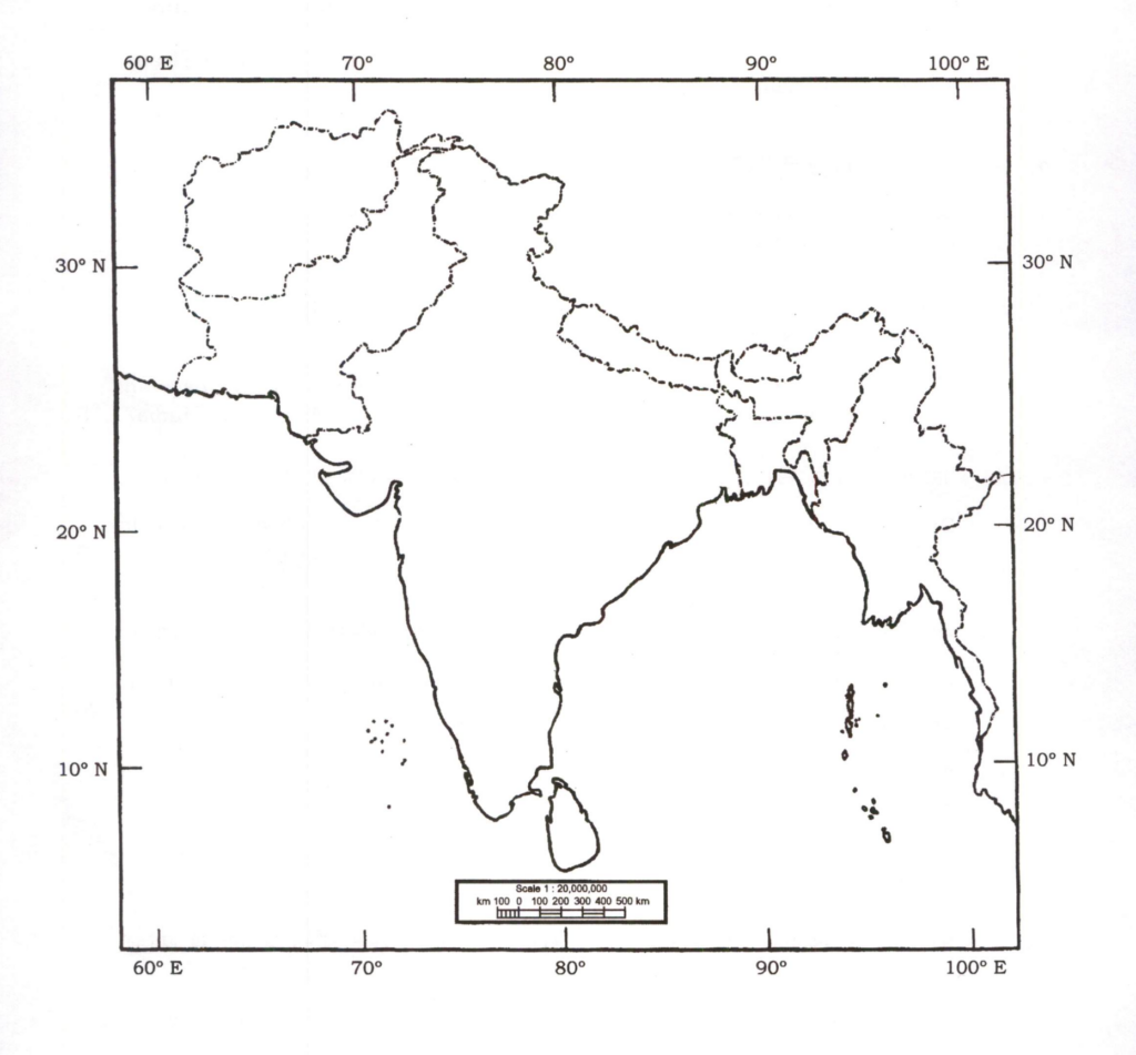
Q1(b) to Q1(d). Answer in about 150 words each (10 × 3 = 30)
- (b) Discuss the basis of the various explanations for the formation of the Shiwalik.
- (c) Conservation and breeding centres are an important component of the Action Plan for Vulture Conservation 2020–2025. Why?
- (d) North-Eastern States in India are geopolitically sensitive and strategically significant. Explain.
Q2. (20 + 15 + 15 = 50)
- (a) Institutional factors are playing a dominant role in controlling agricultural prosperity in India. Justify with evidence.
- (b) The Indian Space Policy, 2023 supports commercial presence in space. In what ways will it benefit the socio-economic development and security of India?
- (c) Discuss the process of formation of conurbations in India and describe their problems.
Q3. (20 + 15 + 15 = 50)
- (a) India has wide-ranging regional disparities in economic development. Explain the patterns, implications and challenges.
- (b) Discuss the variations in the nature of glaciers in India and the emerging issues due to climate change.
- (c) Domestic tourism in India has immense local resource potential. Discuss the reasons and its various dimensions.
Q4. (20 + 15 + 15 = 50)
- (a) Migration is the reflection of regional disparities. What socio-economic and demographic consequences are experienced at the place of origin and destination?
- (b) In spite of various tribal area development programmes in India, tribal areas still lag behind. Discuss critically with examples.
- (c) Water scarcity is an important cause of disputes and conflicts in India. Suggest innovative methods for location-based solutions.
Paper II — Section B
Q5. Answer the following questions in about 150 words each (10 × 5 = 50)
- (a) How are geographic factors influencing the distribution of high annual rainfall in certain parts of India?
- (b) The Indian population belongs to a large number of races. Discuss the spatial distribution of major races.
- (c) Examine the transitional role of technology in the Indian agriculture sector.
- (d) Describe the area-specific strategies for the development of drought-prone areas in India.
- (e) Examine the relationship between seaports and regional development in India.
Q6. (20 + 15 + 15 = 50)
- (a) Industrial waste is diversified. Discuss the potentials and challenges associated with it.
- (b) How is the cultural background of States of India reflected in the attributes of sex and age structure?
- (c) Discuss the targets of focused interventions of the Jal Shakti Abhiyan: Catch the Rain, 2024 in rural and urban areas.
Q7. (20 + 15 + 15 = 50)
- (a) India is playing a very significant role in world affairs. Examine the stands taken by India in important global and regional summits.
- (b) The 73rd Constitutional Amendment Act devolved functions, finances and functionaries for the planning of rural areas in India. Discuss the major achievements with examples.
- (c) How do small and fragmented landholdings affect the agro-ecological system in rural India? What are the resilient steps needed to overcome this issue?
Q8. (20 + 15 + 15 = 50)
- (a) How can the morphology of Indian towns be described historically? Discuss the major features of the first planned city in India after independence.
- (b) Health is the outcome of interaction between physical setting, cultural traits and ecological connection. Explain.
- (c) What are the major regional rapid transit systems developed in India? How are urban problems being addressed by them?
What the 2024 Geography Optional paper actually tested
Twenty-seven questions per paper look like a lot until you map them onto the syllabus. Then the shape of the paper becomes obvious — and so does the reason most aspirants leave marks on the table in the same three or four units every year.
Paper I — unit-wise spread (2024)
| Syllabus unit | Questions | Count |
| Geomorphology | Q1(a), Q2(a), Q4(b) | 3 |
| Climatology | Q1(b), Q2(b), Q3(a) | 3 |
| Oceanography | Q1(c), Q2(c) | 2 |
| Biogeography and soils | Q1(d), Q3(b), Q4(c) | 3 |
| Environmental Geography | Q1(e), Q3(c), Q4(a) | 3 |
| Perspectives in Human Geography | Q5(a), Q6(b) | 2 |
| Economic Geography | Q5(b), Q8(b) | 2 |
| Population and Settlement Geography | Q5(c), Q6(a), Q7(b), Q8(c) | 4 |
| Regional Planning | Q5(d), Q7(c) | 2 |
| Models, Theories and Laws | Q5(e), Q6(c), Q7(a), Q8(a) | 4 |
Paper II — unit-wise spread (2024)
| Syllabus area | Questions | Count |
| Map question | Q1(a) | 1 (20 marks) |
| Physical setting and climate | Q1(b), Q3(b), Q5(a) | 3 |
| Environment, water and hazards | Q1(c), Q4(c), Q5(d), Q6(a), Q6(c) | 5 |
| Agriculture | Q2(a), Q5(c), Q7(c) | 3 |
| Industry, technology and tourism | Q2(b), Q3(c) | 2 |
| Transport, settlements and urban systems | Q2(c), Q5(e), Q8(a), Q8(c) | 4 |
| Population, health and cultural setting | Q4(a), Q5(b), Q6(b), Q8(b) | 4 |
| Regional development and political aspects | Q1(d), Q3(a), Q4(b), Q7(a), Q7(b) | 5 |
Five things the 2024 paper tells you about UPSC’s pattern
- Models and theories took four slots in Section B. Rostow, Mackinder’s Heartland, Whittlesey’s agricultural regions and Christaller’s complementary regions appeared in four separate questions. That is the heaviest theory load of the recent set, and it favours aspirants who can reproduce a model’s structure with a diagram rather than only describe it.
- The compulsory question went narrow and technical. Truncated spurs, the axis of dilation in temperate cyclone formation, Yazoo streams, PAVE — 2024 opened on terms that a general reading of Geomorphology and Climatology does not necessarily surface. Terminology lists are not optional preparation.
- Environmental Geography is now permanently weighted. Social forestry, fragile mountain ecosystems, PAVE, carbon neutrality and the latitudinal gradient in species richness gave environment and biogeography six of the fourteen Section A slots between them. The physical paper is increasingly an environment paper.
- Paper II 2024 was written around policy instruments. The Action Plan for Vulture Conservation, the Indian Space Policy 2023, the Jal Shakti Abhiyan: Catch the Rain 2024 and the 73rd Amendment all appeared by name. Knowing the geography without the scheme name costs marks; naming the scheme without the geography costs more.
- Semiconductors arrived in a Geography paper. Q8(b) of Paper I asked for the spatial changes and emerging patterns of semiconductor manufacturing worldwide — a question that did not exist in this syllabus five years ago. Economic Geography now tracks global industrial restructuring in near real time.
How to use this paper (rather than just read it)
- Write Q1 and Q5 first, under a clock. Ten questions, 150 words each, 100 marks. Give yourself 90 minutes for the ten and see how many you can finish. This single exercise tells you more about your readiness than a week of reading.
- Build a terminology list as you revise. Truncated spurs, Yazoo streams, axis of dilation, PAVE — the 2024 compulsory question is a terminology test in disguise. Keep a running list of every named term in each unit and review it weekly.
- Mark every question you could not start. Not the ones you answered badly — the ones where you had nothing. Those are syllabus gaps, and they are far cheaper to fix than weak answers.
- Practise the four models with diagrams. Rostow, Heartland, Whittlesey and Christaller each have a standard visual. If you can draw all four from memory in under two minutes each, Section B of a 2024-style paper becomes a scoring section rather than a risk.
- Compare your answer against a model answer, not against the syllabus. The gap you need to close is a writing gap. Reading more notes does not close it; seeing the finished shape of a 300-plus answer does.
Two ways to prepare for the papers above
Past papers are the syllabus UPSC actually examines. What you do next with them decides the marks. Two LotusArise systems are built for the two different gaps aspirants have at this stage.
| 300+ Score Pack | Mains Master Kit 2027 | |
| Best for | You already have notes and your gap is answer writing | You are starting Geography Optional and want one complete system |
| Core content | 820 solved PYQ model answers (2013–2026), topic-wise across all 20 units | Complete Notes PDF for Paper I & II — 3,000+ pages covering the full syllabus |
| Also inside | 20 unit-wise PYQ pattern & strategy reports; diagrams and maps inside the answers | Topic-wise test series questions for both papers; 12 months premium article access; 500+ mapped locations |
| Access | 500 days from enrolment | 12 months, all devices, offline |
| Price | ₹1,770 (regular ₹2,500) | ₹1,770 (regular ₹5,000) |
Both are one-time payments with instant access and no subscription. If you are unsure, start with the 300+ Score Pack — answer writing is the constraint for most aspirants who have already read the syllabus once.
Geography Optional Question Paper 2024 — FAQs
Geography Optional question papers — other years
- UPSC Geography Optional Question Paper 2013
- UPSC Geography Optional Question Paper 2014
- UPSC Geography Optional Question Paper 2015
- UPSC Geography Optional Question Paper 2016
- UPSC Geography Optional Question Paper 2017
- UPSC Geography Optional Question Paper 2018
- UPSC Geography Optional Question Paper 2019
- UPSC Geography Optional Question Paper 2020
- UPSC Geography Optional Question Paper 2021
- UPSC Geography Optional Question Paper 2022
- UPSC Geography Optional Question Paper 2023
- UPSC Geography Optional Question Paper 2025
- UPSC Geography Optional Question Paper 2026
- Geography Optional question papers — topic-wise PYQ hub
- Geography Optional 300+ Score Pack — solved PYQ model answers (2013–2026)