

- A geosyncline is a long, narrow and relatively shallow marine depression in which sediments piled up for millions of years while its floor kept subsiding, between rigid masses (forelands) that supplied the sediment and later squeezed it.
- The classical view held that “out of geosynclines have come the mountains”: the thick sediment prism is later compressed, folded and uplifted into fold mountains, as in the Tethys (Himalaya, Alps) and Appalachian troughs.
- The idea ruled mountain-building thought for about a century, until plate tectonics recast geosynclines as sediment wedges of continental margins and ocean basins.
Concept of Geosyncline
Meaning and Characteristics
- Rigid masses and mobile zones: the early globe is pictured as stable continental nuclei ringed by mobile, water-covered belts of heavy sedimentation, the geosynclines.
- Characteristics:
- Length far exceeds width, often by ten times or more.
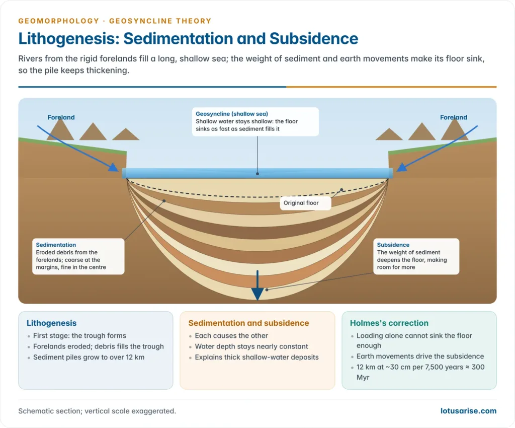
- Sedimentation and subsidence go together: the floor sinks as sediment accumulates, so the water stays shallow.
- Mobile: location, shape and extent changed through geological time with earth movements.
- Bordered by two rigid forelands, which are eroded to fill them.
Evidence from Fold Mountains
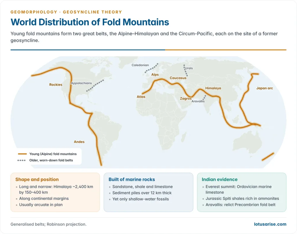
- Marine sedimentary rocks: fold mountains are built mainly of sandstone, shale and limestone that carry marine fossils.
- Great thickness but shallow-water fossils: sediment piles exceed 12 km, yet the fossils are of shallow-sea organisms, which is possible only if the floor sank steadily as it filled.
- Shape and position: fold belts are long and narrow (the Himalaya runs about 2,400 km but is only 150–400 km wide), lie along continental margins and are usually arcuate.
- Indian example: the summit of Mount Everest is Middle Ordovician marine limestone, about 450 million years old, with brachiopod and crinoid fossils laid down in a shallow Tethyan sea.
Evolution of the Concept
James Hall (1859) and James Dwight Dana (1873)
- James Hall, working on the northern Appalachians, found the folded Palaeozoic strata to be shallow-water marine sediments about 12 km thick, ten to twenty times thicker than unfolded strata of the same age in the interior lowlands.
- The floor, he argued, subsided as sediment accumulated, and mountain building followed this long down-warping.
- James Dwight Dana found such thickening in most ranges and in 1873 named the long, narrow, shallow and sinking trough a “geosynclinal”, later shortened to geosyncline.
Émile Haug (1900)
- Émile Haug defined geosynclines as relatively deep-water belts, much longer than wide, and drew palaeogeographic maps placing present fold ranges on the sites of former geosynclines between Mesozoic rigid masses:
| Rigid masses (5) | Geosynclines between them (4) |
|---|---|
| North Atlantic | Rockies |
| Sino-Siberian | Ural |
| Africa–Brazil | Tethys |
| Australia–India–Madagascar | Circum-Pacific |
| Pacific |
- Sedimentation is systematic, coarse at the margins and fine in the centre; folding is by compression from the margins, though some geosynclines never yield mountains.
- Criticism: his map shows far more land than sea, with no account of where those landmasses went after the Mesozoic, and deep-water geosynclines clash with the shallow-water fossils of fold mountains.
J. W. Evans
- J. W. Evans held that geosynclines vary too much to fit one model, though all share sedimentation, subsidence and folding. They may lie:
- between two landmasses: Tethys between Laurasia and Gondwanaland;
- in front of a mountain or plateau: the trough south of the rising Himalaya, later filled to form the Indo-Gangetic plains;
- along continental margins or off a river mouth.
Charles Schuchert (1923)
- Charles Schuchert classified geosynclines by size, location and evolutionary history:
| Type | Form | History | Example |
|---|---|---|---|
| Monogeosyncline | Very long, narrow, shallow; within or along a continent | One cycle of sedimentation and folding | Appalachian |
| Polygeosyncline | Longer and wider | Several orogenic phases; internal geanticlines | Rockies, Ural |
| Mesogeosyncline | Long, deep, mobile, enclosed by continents | Long, complex, repeated phases | Tethys (Alps, Himalaya); Mediterranean is a remnant |
Arthur Holmes
- Arthur Holmes argued that sediment weight alone cannot sink the floor far enough, so earth movements must drive the subsidence, which is gradual.
- He gave four modes of origin, most of them driven by his mantle convection currents:
| Mode | Mechanism | Examples cited |
|---|---|---|
| Magma migration | Magma moves out of the middle crustal layer; the crust above sags | Coral and Tasman seas |
| Metamorphism | Converging currents turn the lower crust into denser eclogite; the crust sinks | Caribbean, Banda Sea |
| Compression | Converging currents press the outer layer down | Persian Gulf, Indo-Gangetic trough |
| Thinning of sial | Diverging currents stretch the sial, or split the continent | Tethys (stretching); Ural (splitting) |
- The last two modes are the most durable part of his scheme, since they foreshadow subsidence at convergent and divergent plate margins.
Hans Stille and Marshall Kay
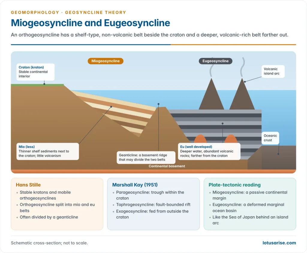
- Hans Stille divided the crust into stable kratons (his 1936 shortening of Kober’s kratogen), either hochkraton (continental) or tiefkraton (oceanic), and mobile orthogeosynclines.
- Within an orthogeosyncline he separated two belts, often divided by a geanticline:
- Eugeosyncline (eu, well developed): abundant volcanic rocks, deeper water, farther from the craton.
- Miogeosyncline (mio, less): little volcanism, thinner sediment, next to the craton.
- Marshall Kay (1951), in North American Geosynclines, extended the scheme to troughs within or beside cratons:
| Type | Nature |
|---|---|
| Orthogeosyncline | Linear belt between craton and ocean, made of a eugeosyncline and a miogeosyncline; deformed into a fold chain |
| Parageosyncline | Trough lying within the craton |
| Zeugogeosyncline | Parageosyncline with adjoining uplifts supplying sediment |
| Autogeosyncline | Parageosyncline without marginal uplifts |
| Exogeosyncline | Trough filled from an uplift outside the craton |
| Taphrogeosyncline | Fault-bounded trough (graben, rift valley) |
| Epieugeosyncline | Trough lying on a deformed eugeosyncline |
| Paraliageosyncline | Sediment wedge along a coast, such as the Gulf Coast of the United States |
- A structural grouping is also used: inter-continental (between two landmasses; Ural), circum-continental (along continental margins; Appalachian) and circum-oceanic (where continental and oceanic margins meet; Stille’s marginal geosyncline).
Kober’s Geosynclinal Orogen Theory
Base and Driving Force
- Leopold Kober, Austrian geologist, set out the theory in Der Bau der Erde (1921) to trace the history of mountains from the mobile zones between ancient rigid masses.
- Orogen and kratogen: the mobile water belts on the sites of today’s mountains are orogens (places of mountain building); the rigid masses around them are kratogens.
- Kratogens include the Canadian, Baltic and African shields and Peninsular India; continents grew outwards from these nuclei.
- Driving force: contraction of a cooling Earth pushes the forelands towards each other, squeezing and folding the geosynclinal fill.
Stages of Geosynclinal Evolution
Lithogenesis
- Creation, sedimentation and subsidence: contraction forms the geosyncline; the forelands are eroded and their debris spreads over its floor.
- The load deepens the floor, making room for more sediment, and the pile thickens over millions of years.
Orogenesis
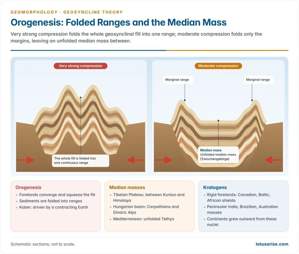
- Squeezing and folding: the forelands converge, and the compressed sediment is folded into ranges.
- Two outcomes:
- Very strong compression folds the whole fill into one continuous range.
- Moderate compression folds only the edges into two marginal ranges, leaving an unfolded median mass (Zwischengebirge) between them.
- Kober’s median masses: the Tibetan Plateau (between Kunlun and Himalaya), the Hungarian basin (between Carpathians and Dinaric Alps) and the Mediterranean (unfolded Tethys).
Gliptogenesis
- Gradual rise and denudation: the new ranges keep rising while weathering and erosion lower their height.
- As erosion unloads the range, the crust rebounds isostatically.
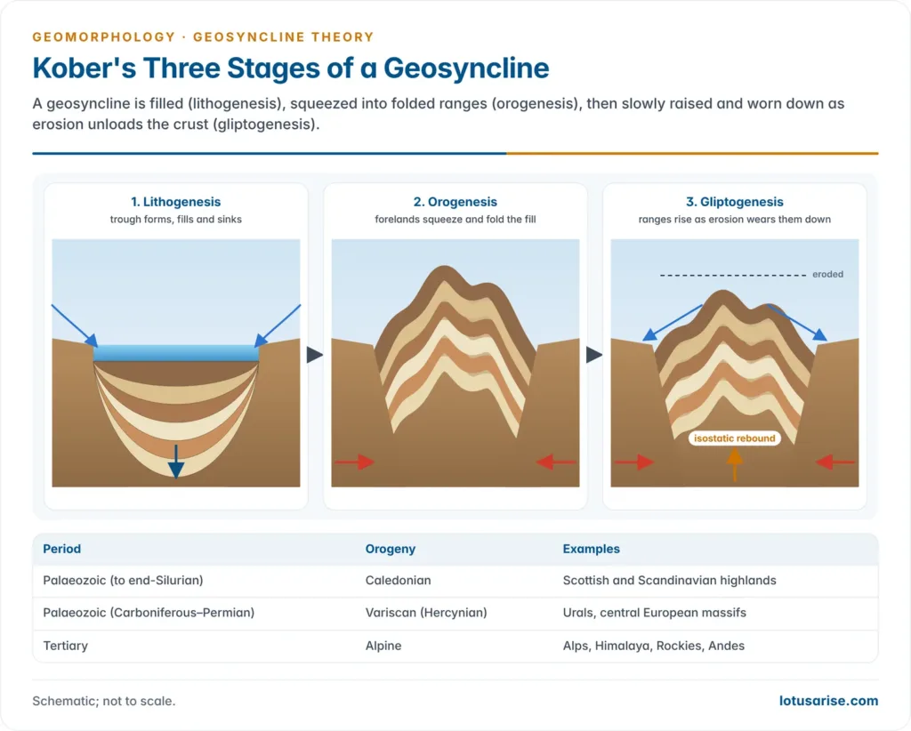
Periods of Mountain Building
| Period | Orogeny | Examples |
|---|---|---|
| Precambrian | Three little-known orogenies | Ancient shield belts |
| Palaeozoic (to end-Silurian) | Caledonian | Scottish and Scandinavian highlands |
| Palaeozoic (Carboniferous–Permian) | Variscan (Hercynian) | Urals, central European massifs |
| Tertiary | Alpine | Alps, Himalaya, Rockies, Andes |
- Indian example: the Aravallis, among the world’s oldest fold belts, are a worn-down Precambrian range; the Himalaya is the young Alpine chain.
Evaluation
- Merits:
- Ties the thick marine sediments, their folding and the long, narrow shape of fold belts into one sequence.
- The median mass usefully explains plateaus and basins enclosed by ranges.
- Recognises mountain building as episodic, grouped into distinct orogenic periods.
- Criticism:
- Thermal contraction is far too weak to shorten the crust by hundreds of kilometres, and radioactive heat undercuts the cooling-Earth premise.
- It cannot explain the one-sided movement shown by nappes, or why rigid forelands should move at all.
- The Tibetan Plateau is not an unfolded median mass but thickened, uplifted crust.
Plate Tectonic Reinterpretation
Why the Classical Concept Failed
- Geosynclinal theory had no mechanism for moving forelands; sea-floor spreading and plate motion supplied one in the 1960s.
- Robert S. Dietz (1963) read ancient geosynclines as collapsed continental rises, like the sediment prisms of today’s Atlantic margin; John F. Dewey and John M. Bird (1970) mapped geosynclinal belts onto plate margins, explaining mountains by subduction and collision.
- A margin on a plate boundary is active; one carried away from a spreading ridge, like the east coast of North America, is passive.
Geoclines of Passive Margins
- As a passive margin drifts from the ridge, the lithosphere cools, becomes denser and subsides, and sediment keeps accumulating on the shelf, slope and rise.
- The body is a one-sided wedge parallel to the continent and open towards the ocean, unlike a trough fed from mountains on both sides, so Dietz and Holden (1966) coined miogeocline, and geocline replaced geosyncline.
| Feature | Miogeocline | Eugeocline |
|---|---|---|
| Position | Continental shelf | Foot of continental slope, continental rise |
| Basement | Thinned continental crust | Oceanic crust |
| Sediment | Shallow-water marine wedge | Deep-sea turbidites and muds |
| Example | Northern Gulf of Mexico, US Atlantic shelf | Atlantic continental rise |
- Miogeoclines host major petroleum reserves, as in the northern Gulf of Mexico, where the wedge is over 10 km thick, and at Mumbai High on India’s western passive margin.
- The Bengal Fan, fed by the Ganga and Brahmaputra, is the largest submarine fan on Earth, with sediment up to 16.5 km thick: a present-day “geosyncline” in the making.
Classical Terms in Plate Settings
| Classical idea | Plate-tectonic equivalent | Indian example |
|---|---|---|
| Miogeosyncline | Passive-margin shelf wedge | Western continental shelf (Mumbai offshore) |
| Eugeosyncline | Continental rise, accretionary wedge, arc volcanics, marginal-sea basin (Sea of Japan) | Andaman–Nicobar accretionary prism |
| Mesogeosyncline (Tethys) | Closed ocean; ophiolites along the suture | Indus–Tsangpo suture ophiolites, Ladakh |
| Exogeosyncline / trough before a range | Foreland basin from lithospheric flexure | Indo-Gangetic plains |
| Taphrogeosyncline | Continental rift basin | Gondwana grabens of Damodar and Godavari |
| Orogenesis by contraction | Subduction and continent collision | India–Asia collision, about 55–50 million years ago |
- Current view: the geosyncline is obsolete as a theory but survives as a descriptive term for thick linear sediment belts; mountains are now explained by the Wilson cycle of ocean opening and closing.
Previous Year Questions
2018Evaluate how far Kober’s geosyncline theory explains the mountain building process.2002Write short note: Geosyncline.





Its perfect Sir ji… Good 😚
Unbelievable notes thanks a lot
Best notes
Did india have volcano ..near Andhra Pradesh??
very well explained .
sir can you also add criticism of Kober’s theory
Sir aise hi notes provide karaye hamare liye help ho jati hai