

Evaluate how far Kober’s geosynclinal theory explains the mountain building process. (2018)
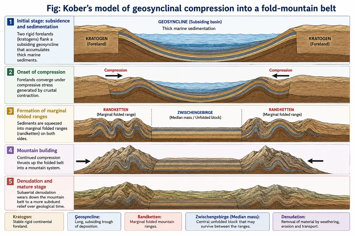
- Leopold Kober, an Austrian geologist, combined the geosyncline concept of James Hall and James Dwight Dana, as developed by Émile Haug, with his own view of orogenesis: mountains grow out of geosynclines squeezed between rigid landmasses.
- He belongs to the contraction school with Harold Jeffreys — a cooling, shrinking Earth supplies the compressive force. As James Alfred Steers put it:
- “Kober is definitely a contractionist, contraction providing the motive force for the compressive stress.” — James Alfred Steers
- An evaluation must therefore separate what the theory describes well from what it explains — its mechanism.
The theory in outline
- Orogen and kratogen: long, mobile water-filled troughs (geosynclines, which Kober called the orogen) lay between stable rigid blocks, the kratogens or forelands — the Canadian, Baltic, Siberian, African, Brazilian and Australian shields and Peninsular India. Hans Stille later shortened kratogen to kraton.
- Three stages:
- Lithogenesis — forelands are eroded; sediment fills the geosyncline, whose floor subsides under the load, so very thick marine sequences build up;
- Orogenesis — contraction drives the two forelands towards each other; the squeezed sediments rise as two marginal ranges, the Randketten. If compression is moderate, the middle stays unfolded as a median mass (Zwischengebirge); if intense, the whole fill is folded into recumbent folds and nappes;
- Gliptogenesis — the ranges rise and are gradually worn down by denudation.
- Time: six orogenic periods — three little-known Precambrian ones, the Caledonian, the Variscan and the Tertiary Alpine.
How far it explains — the strengths
- Sediment source and thickness: the marine, fossil-bearing strata now high in the Himalaya and Alps, far thicker than strata of the same age on the shields, show that fold belts really do grow from thick basin fills — James Hall’s Appalachian evidence still holds.
- Opposite vergence on two sides of one belt: Kober explained why the Mediterranean ranges fold in opposite directions.
- The African foreland moving north produced the Betic Cordillera, Pyrenees, Alps proper, Carpathians, Balkans and Caucasus;
- the European foreland moving south produced the Atlas, Apennines, Dinarides, Hellenides and Taurides.
- North-directed Carpathians facing south-directed Dinarides across Hungary is a real structural fact.
- Median masses fit real intermontane plateaus and basins:
- Tibetan Plateau between the Kunlun and the Himalaya;
- Iranian Plateau between the Elburz and Zagros;
- Anatolian Plateau between the Pontic and Taurus ranges;
- Hungarian Plain between the Carpathians and Dinarides;
- the Mediterranean Sea between the Alps and the Atlas.
- Intensity controls style: his rule that moderate squeezing leaves a median mass while intense squeezing folds the whole fill into recumbent folds and nappes matches the stacked Helvetic, Penninic and Austroalpine nappes of the Alps.
- Both forelands move: Eduard Suess held that only one side (the backland) advanced against a fixed foreland; palaeomagnetism and sea-floor spreading show both India and Eurasia in motion, closer to Kober’s picture; GPS today records India still closing on Eurasia at roughly 4–5 cm a year.
Where it fails — the mechanism and the map
- Inadequate force: cooling contraction cannot produce shortening of hundreds of kilometres in the Alps, let alone the thousands of kilometres of India–Asia convergence; and once radiogenic heat was discovered, a steadily cooling, shrinking Earth itself became doubtful.
- Geographical limit: it handles east–west belts between two shields but not the north–south Andes and Rockies, which face an ocean, not a second foreland — they are products of ocean–continent subduction.
- Missing phenomena: no explanation for volcanic arcs, Benioff zones with deep earthquakes, ophiolites marking sutures, or sea-floor spreading — all central to modern orogeny.
- Median masses reinterpreted:
- Tibet is not an unfolded block. Lin Ding, Paul Kapp and colleagues (2022) show it was assembled from microcontinents; India began colliding with Asian rocks 65–60 million years ago; high east–west mountain belts stood in southern and central Tibet by ~55 and ~45 million years ago; and later uplift was driven mainly by delamination and break-off of subducted lithosphere.
- The Hungarian (Pannonian) Basin and the Tyrrhenian Sea are young extensional back-arc basins, and the Basin and Range is stretched crust — products of extension, not of passive survival between two squeezing forelands.
- The geosyncline itself: plate tectonics splits it into passive-margin sediment wedges and deep-ocean and trench deposits on different plates, often thousands of kilometres apart before collision — not one trough between two shields.
The plate-tectonic reinterpretation
- Kratogen → continental plate with its craton; geosyncline → ocean basin plus its margin sediments; orogenesis → subduction, then continent–continent collision; gliptogenesis → isostatic rebound and denudation of the thickened belt.
- The Tethys that Kober compressed between Angaraland and Gondwana is now read as an ocean closed by subduction before India struck Asia; the Himalaya remains the type example under both theories, for different reasons.
- Judgement: Kober’s theory explains the architecture of Alpine-type fold belts — thick marine source sediments, bilateral marginal ranges with opposite vergence, intermontane plateaus — reasonably well, but fails on the driving force, on Pacific-type ranges and on the true nature of its median masses; its lasting value is as a descriptive framework later re-explained, not as a causal theory of mountain building.