

India is home to a diverse range of mountain ranges, including the Himalayas, Karakoram, Aravalli, Western Ghats, Eastern Ghats, Vindhya, and Satpura. The Himalayas are the most prominent, forming a northern boundary and encompassing several sub-ranges. Other significant ranges include the Karakoram, Aravalli, Western and Eastern Ghats, and the Vindhya and Satpura ranges.
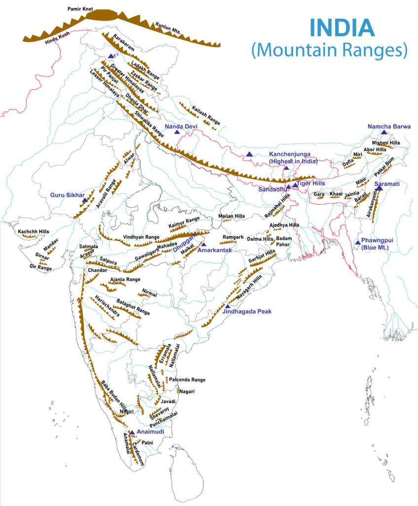
Major Mountain Ranges in India
1. The Himalayas
- The Himalayas are one of the major mountain ranges of the world.
- They are young fold mountains formed by the collision of the Indian Tectonic Plate with the Eurasian Plate, millions of years ago.
- They are bordered on the northwest by the Karakoram and the Hindu Kush ranges, on the north by the Tibetan Plateau, and on the south by the Indo-Gangetic Plain.
- The approximate length of the Himalayas is 2,500 km from east to west, and their width varies between 160-400 km from north to south.
- They are spread across 5 countries: India, Nepal, Bhutan, China, and Pakistan.
- The Himalayas are further divided into three sub-ranges (North to South):
- Greater Himalayas
- Middle Himalayas
- Outer Himalayas
i. The Greater Himalayas
- Also known as Himadri or the Inner Himalayas.
- They are the northernmost and the highest mountain range of the Himalayas.
- The average elevation of this range is 6000 m.
- They host several of the world’s highest peaks, including Mount Everest (8,849 m) [highest peak in the world, located in Nepal], Kangchenjunga, and Nanga Parbat.
- The highest peak in the Indian part of the Himalayas is Kangchenjunga (8,598 m)**. [K2 (8,611 m) is the overall highest peak in India. However, it lies in the Karakoram Range, not the Himalayas.]
- The Gangotri Glacier and the Satopanth Glacier lie within this range.
- The Yamuna and the Ganga rivers originate from this part of the Himalayas.
ii. The Middle Himalayas
- Also known as the Lower Himalayas or Lesser Himalayas or Himachal.
- It lies to the south of Himadri and has an average elevation of 3700-4500 m.
- The Pir Panjal (Jammu & Kashmir), Dhauladhar (Himachal Pradesh), and Nag Tibba (Uttarakhand) are some major ranges of the Middle Himalayas.
- Nainital, Shimla, Ranikhet, Dharamshala, and Mussoorie are some famous hill stations of this range.
iii. The Outer Himalayas
- Also known as Shivalik Hills.
- This is the outermost and southernmost range of the Himalayas.
- It stretches over about 2400 km from the Indus Gorge in the northwest to the Brahmaputra in Assam.
- It is 10–50 km wide with an average elevation of 1,500–2,000 m.
- The Shivalik Hills are known by several names locally:
- Dafla Hills in Assam and Arunachal Pradesh
- Miri, Abor, and Mishmi Hills in Arunachal Pradesh
- Dundwa Range in northern Uttar Pradesh
- Churia Range in Nepal.
- The formation of Doons and Duars valleys is an important feature of the Shivaliks. These are alluvial floodplains, called Doons in northwestern India and Duars in northeastern India. (e.g. Dehradun)
2. Purvanchal Range
- Also known as the Eastern Mountains, it is a sub-mountain range of the Himalayas in northeast India.
- It is an eastern extension of the Himalayan Range System and lies south of the Brahmaputra valley.
- It bends sharply to the south beyond the Dihang River gorge and spreads along the eastern boundary of India with Myanmar.
- Patkai Hills, Naga Hills, Mizo Hills, and Manipur Hills are part of this range.
3. The Trans-Himalayas
- Trans-Himalayas lies immediately to the north of the Great Himalayan Ranges.
- It extends in a west–east direction parallel to the main Himalayan range.
- It is located north of the Yarlung Tsangpo (Brahmaputra) River.
- There are three major ranges of the Trans-Himalayas in India. They are (North to South):
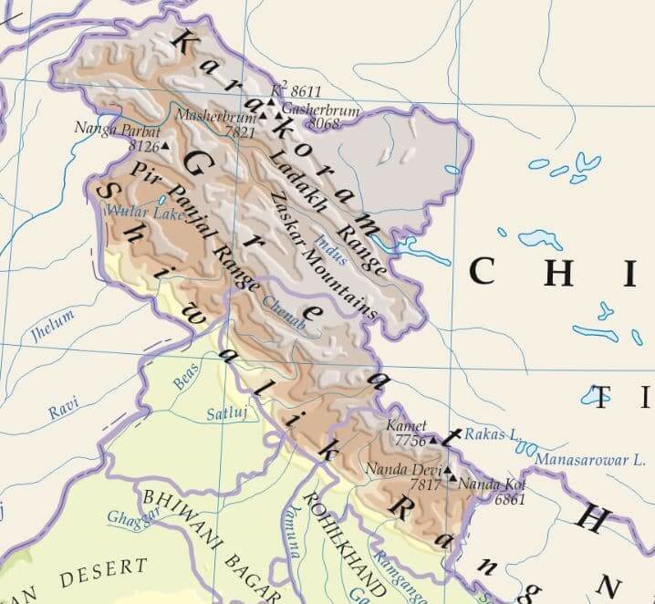
- Karakoram Range
- Ladakh Range
- Zanskar Range
- The Kailash Range located in Tibet is also part of the Trans-Himalayan Range.
- K2 (8,611 m), the highest peak in India (second-highest in the world) lies in the Karakoram Range. It is also known as Mount Godwin-Austen
- Several important mountain passes in India, such as Khardung La, Zoji La, Chang La, and Umling La are located on these mountain ranges.
4. Aravalli Range
- The Aravalli is a residual mountain (a mountain that has been subjected to weathering and erosion for millions of years).
- It is a very old fold mountain range.
- It extends for about 700 km, starting near Delhi, passing through southern Haryana, Rajasthan, and ending in Ahmedabad, Gujarat.
- it hosts the famous hill station of Mount Abu.
- Guru Shikhar (1,722 m) in Rajasthan is the highest peak of this range.
5. Vindhya Range
- It is a complex, discontinuous chain of mountain ridges, hill ranges, highlands, and plateau escarpments.
- The Vindhyas has mythological significance as most ancient Hindu texts consider it as the southern boundary of Aryavarta (regions settled by Indo-Aryan tribes)
- Presently, it is considered to be the traditional boundary between north and south India.
- Several tributaries of the Ganga-Yamuna system, including Chambal, Betwa, Ken, and Parbati originate from the Vindhya Range.
- It acts as a watershed between the Ganges river system and the river systems of south India.
- It is located north of the Narmada River and runs almost parallel to the Narmada Valley.
6. Satpura Range
- The Satpura range rises in eastern Gujarat, runs east through the border of Maharashtra and Madhya Pradesh, and ends in Chhattisgarh.
- It is formed by a series of scarped plateaus and has a general elevation of 600-900 m.
- It is a classic example of relict mountains, which are highly denuded and form discontinuous ranges.
- It lies to the south of the Vindhya Range.
- It runs parallel to the Vindhyas and lies between the Narmada and the Tapi rivers.
- The Narmada River originates near Amarkantak in the Satpura Range.
7. Western Ghats
- It is an almost continuous chain of mountains stretching for 1,600 km along the western coast of the Indian peninsula.
- The average elevation is about 1500 m with height increasing from north to south.
- it traverses six Indian states: Gujarat, Maharashtra, Goa, Karnataka, Kerala, and Tamil Nadu.
- Western Ghats are locally known by different names such as:
- Sahyadri in Maharashtra
- Nilgiri Hills in Karnataka and Tamil Nadu
- Anaimalai Hills and Cardamom Hills in Kerala
- It is one of the Natural UNESCO World Heritage Sites in India.
- It hosts numerous hill stations like Ooty, Munnar, and Mahabaleshwar.
- Anai Mudi (2,695 m) in Kerala is the highest peak in the Western Ghats and South India. It lies on the Anaimalai Hills.
- Doda Betta (2,637 m) in Tamil Nadu is the highest peak of the Nilgiri Hills.
- The Nilgiri Hills are located at the trijunction of three states – Karnataka, Kerala, and Tamil Nadu.
- The Western and the Eastern Ghats meet each other at the Nilgiri Hills.
8. Eastern Ghats
- These are a discontinuous range of mountains along India’s eastern coast and are less prominent than the Western Ghats.
- They mostly comprise low hills and are highly eroded by the rivers such as the Mahanadi, Godavari, Krishna, and Kaveri.
- The Eastern Ghats pass through five Indian states: Odisha, Andhra Pradesh, Telangana, Karnataka, and Tamil Nadu.
- Some important ranges of the Eastern Ghats:
- Javadi Hills in Tamil Nadu
- Palkonda Hills and Seshachalam Hills in Andhra Pradesh
- Nallamala Hills in Andhra Pradesh and Telangana
- Mahendragiri Hills in Odisha
- Jindhagada Peak (1690 m) and Arma Konda or Sitamma Konda (1,680 m) in Andhra Pradesh and Mahendragiri (1,501 m) in Odisha are some important peaks in this range.
List of Mountain Ranges in India
Mountain Ranges in North India – North to South
| Mountain Ranges | States | Highest Peak | Remarks |
|---|---|---|---|
| Saltoro Mountains | Ladakh | Saltoro Kangri | Sub-range of the Karakoram |
| Karakoram | PoK, Ladakh | Godwin-Austen or K2 8,611 m | Highest peak in India |
| Deosai Mountain | J&K | ||
| Ladakh Range | J&K | ||
| Zanskar Range | J&K | Kamet Peak 7,756 m | |
| Pir Panjal Range | J&K, Himachal Pradesh | Indrasan 6,221 m | |
| Zabarwan Range | J&K | Part of Pir Panjal | |
| Dhauladhar Range | J&K | ||
| Kishtwar Himalaya | J&K | Bharanzar | |
| Garhwal Himalaya | Uttarakhand | ||
| Dundwa Range | Northern UP | Part of Sivalik Hills |
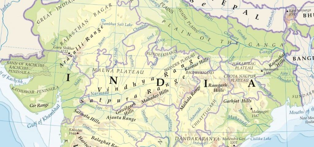
Mountain Ranges in Central India – West to East
| Mountain Ranges | States | Highest Peak | Remarks |
|---|---|---|---|
| Girnar Range | Gujrat | ||
| Aravalli Range | Gujrat Rajasthan Haryana Delhi | Guru Shikhar | oldest fold mountains in India |
| Malwa Plateau | MP Rajasthan | ||
| Rajpipla Hills | Gujrat | Part of Satpura | |
| Gawilgarh Hills | Maharashtra MP | Part of Satpura | |
| Mahadeo Hills | MP | Mount Dhupgarh | Part of Satpura |
| Bhanrer Range | MP | Part of Vindhya | |
| Bhander Plateau | MP | ||
| Maikal Hills | Chhattisgarh | Part of Satpura | |
| Kaimur Range | Jabalpur, MP | Part of Vindhya | |
| Baghelkhand Plateau | UP | ||
| Sonpar Hills | MP | ||
| Vindhya Range | Gujrat MP UP Bihar Chhattisgarh | Sad-bhawna Shikhar or Kalumar peak | |
| Satpura Range | Gujarat Maharashtra MP Chhattisgarh | Mount Dhupgarh |
Chota Nagpur Plateau – North to South
| Mountain Ranges | States |
|---|---|
| Rajmahal Hills | Jharkhand |
| Hazaribagh Plateau | Jharkhand |
| Mailan Hills | Chhattisgarh |
| Ranchi Plateau | Jharkhand |
| Hazaribagh Hills | Jharkhand Chhattisgarh |
| Ramgarh Hills | Chhattisgarh |
| Garhjat Hills | Jharkhand Chhattisgarh Odisha |
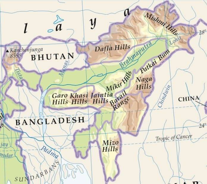
Mountain Ranges in North East India
| Mountain Ranges | States | Highest Peak | Remarks |
|---|---|---|---|
| West to East & South to North | |||
| Dafla Hills | Arunachal Pradesh | Part of Purvanchal | |
| Miri Hills | Arunachal Pradesh | ||
| Abor Hills | Arunachal Pradesh | ||
| Mishmi Hills | Arunachal Pradesh | ||
| Kangchenjunga | Nepal Sikkim | 3rd highest mountain in the world 2nd in India | Part of eastern Himalayas |
| West to East | |||
| Garo Hills | Meghalaya | ||
| Khasi Hills | Meghalaya | Shyllong 1,968 m | Shillong city situated on it |
| Jaintis Hills | Meghalaya | ||
| Mikir Hills | Assam | ||
| Rengma Hills | Assam | ||
| North to South | |||
| Patkai Bum | Arunachal Pradesh | ||
| Naga Hills | Nagaland | Mount Saramati | |
| Langpangkong Range | Nagaland | ||
| Barail Range | Assam Nagaland | Part of Purvanchal | |
| Laimatol Range | Manipur | ||
| Bhuban Hills | Assam Mizoram | ||
| Atharamura Range | Tripura | Part of Siwalik Hills | |
| Lushai Hills or Mizo Hills | Mizoram | Phawngpui | Blue Mountain |
Western Ghats Mountains – North to South
| Mountain Ranges | States | Highest Peak | Remarks |
|---|---|---|---|
| Satmala Hills | Maharashtra | Dhodap | |
| Ajanta Hills | Maharashtra | ||
| Harishchandra Range | Maharashtra | Harischandragarh | |
| Balaghat Range | Maharashtra | ||
| Kudremukh | Chikkamagaluru, Karnataka | Kudremukha | |
| Baba Budan Hills | Karnataka | Mullayanagiri 1930 m | kurinji blooms |
| Nilgiri Mountains | Tamil Nadu | Doddabetta 2,637 m | Eastern & Western Ghats meet |
| Akamala Machad Hills | Thrissur, Kerala | Vazhani sanctuary Vazhani Dam | |
| Anaimalai Hills | Tamil Nadu Kerala | Anamudi 2,695 m | Anamudi is the highest peak in south India World Heritage Site |
| Palani Hills | Tamil Nadu Kerala | Vandaravu | |
| Cardamom Hills | Tamil Nadu Kerala | cardamom spice cultivation | |
| Varushnad Hills | Tamil Nadu | Part of Cardamom |
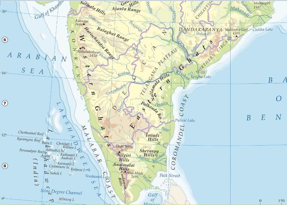
Eastern Ghats Mountains – North to South
| Mountain Ranges | States | Remarks |
|---|---|---|
| Nayagarh Hills | Orissa | |
| Bastar Plateau | Chhattisgarh | |
| Nallamala Hills | AP Telangana | |
| Erramala Hills | Andhra Pradesh | |
| Velikonda Range | Andhra Pradesh | |
| Palkonda Range | Andhra Pradesh | |
| Seshachalam Hills | Andhra Pradesh | Tirupati City |
| Nagari Hills | Andhra Pradesh | |
| Javedi Hills | Tamil Nadu | |
| Melagiri Range | Tamil Nadu | |
| Shevaroy Hills | Tamil Nadu | |
| Pachaimalai Hills | Tamil Nadu | |
| Sirumalai Hills | Tamil Nadu |
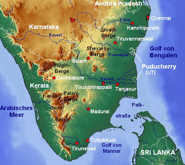
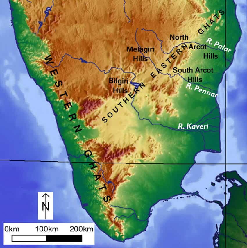
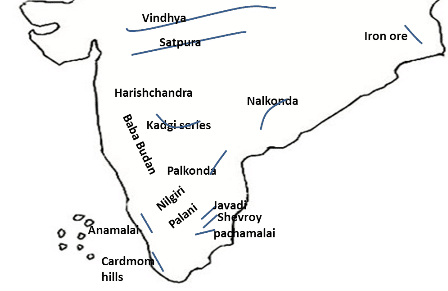
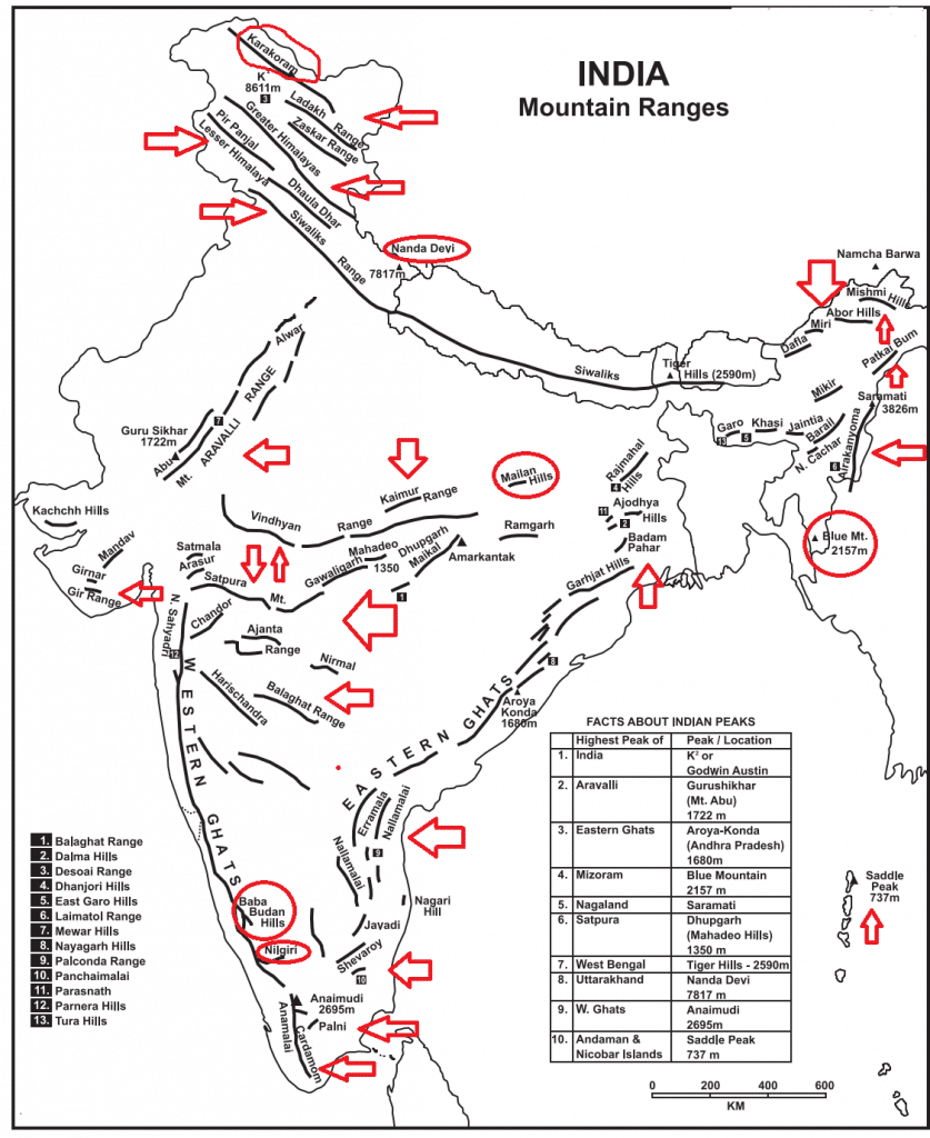

Major Mountain Ranges in India (with few Details)
CARDAMOM HILLS :
- Southernmost part of the Western Ghats, in Kerala and Tamil Nadu
- Named after the cardamoms which are grown here, beside pepper and coffee
- Has the Shencottah Gap
- Climatic barrier, source of many rivers
- So many forest reserves for ecological conservation, source of HEPs
PALANI HILLS :
- Mountains of Tamil Nadu east of the Anaimudi Peak
- North of Vaigai River
- Mostly within Dindigul district
- Hill station of Kodaikanal
- Wildlife Sanctuary and National Park
ANAIMALAI HILLS :
- Anaimalai means ‘Elephant Hills’
- Located between Kerala and Tamil Nadu, south of the Palghat Gap
- Highest peak -Anaimudi (Idukki district, Kerala )
- Many sanctuaries and parks
- Trekking destination
- Tea, coffee, rubber and teak forests
NILGIRI HILLS :
- Trijunction of Tamil Nadu, Kerala and Karnataka, north of the Palghat
- Meeting point of the Eastern and Western ghats
- Nilgiri Biosphere Reserve and other conservation areas
- Highest peak – Doddabetta, 4 km from Otty
- So many falls Pykara, Catherine, Kotagiri
BABA BUDAN HILLS :
- Part of the Western Ghats in the Chikamangaluru District of Karnataka
- Highest peak- Mullayangiri
- Baba Budan was a 17th century sufi, who is believed to have introduced coffee in India
- Known for coffee cultivation
VARUSHNAD HILLS :
- South of the Vaigai River and southwest of Madurai, up to the Cardamom Hills
- Eastern offshoot of the Western Ghats
- Cumbum Valley (Vaigai) divides it from the Western Ghats
- Source of Arjuna and Gunnar rivers
SIRUMALAI HILLS :
- Between Vaigai (S) and Kaveri in Tamil Nadu
- Source of Valiyar and Manimuttar rivers
- Dindigul is the main city nearby it
- Hill station: Sirumalai
PANCHAIMALAI HILLS :
- Panchai mean ‘green’ and malai means ‘hills’
- Between Kaveri and Vellar rivers in Tamil Nadu
- Haven of tribals
- Average elevation : 500m to 1000m
- Good for trekking and enjoying nature
- Namakkal is the main city
SHEVROY HILLS :
- Between Vellar and Ponnaiyar rivers in Tamil Nadu
- Around Salem city
- Sanatorium and several old coffee plantations
- Tourist attraction
- Source of Turunanimuttai, Vellar, Gomukha and Manimukta rivers
JAVADI HILLS :
- Northern Tamil Nadu in Vellar district
- Between Ponnaiyar and Palar rivers
- Bisected into eastern and western sections by Cheyyar and Agaram, tributaries of the Palar
- Sparsely populated
- Grains, legumes, oilseeds are chief crops
NAGARI HILLS :
- Southernmost part of Andhra Pradesh, west of the Pulicat Lake in Chittur District
- Main city – Nagari
- ‘Nag’ means nose in Telugu
- Beautiful picnic spot
- Highest cliff: Nagari Nose
PALKONDA RANGE :
- Arc-shaped mountain between Penneru and Palar rivers
- Relict of mountains formed during the Cambrian Period
- Main crops- Jowar,peanuts
- Formed of quartzites, slates and lavas
- Source of rivers
- Densely forested
VELIKONDA RANGE :
- Part of the Eastern Ghats
- Southeast of Andhra Pradesh, east of the Nallmalla Hills
- Strongly folded and faulted
- Assumed to be elevated during the Cambrian Period, now a relict range
- Sparsely wooded
- Chenchu tribal people live here
MELAGIRI RANGE :
- Smaller hill located south of Bangalore in Karnataka and Tamil Nadu
- Range of hills, part of the Eastern Ghats
- Melagiri Sanctuary is located here
- Arkaveti River flows through the range
- Hosur city, Bennerghatta NP and Kolar gold fields are near to it
VELIKONDA :
- Located in the southeastern part of Andhra Pradesh
- Forms part of the Eastern Ghats
- Parallel to the Coromandel Coast
- Crossed by the Penneru River
NALLAMALLA RANGE :
- Between Penneru and Krishna
- Parallel to the Coromandel Coast
- Part of the Eastern Ghats
- Old mountain extensively weathered and eroded
- Largest stretch of undisturbed forests in SouthernIndia excluding the Western Ghats
- Srisailam Tiger Reserve
ERRAMALA RANGE :
- A range of low hills in southern India, in Kurnool district of Andhra Pradesh
- Between Krishna and Penneru rivers
- West of Nallamalla Range
HARISHCHANDRA RANGE :
- Eastward spur of the Western Ghats, in Maharashtra
- Average elevation -600m.
- Elevation gradually decreases towards the southeast
- Flat topped, consisting of basaltic lava
- Slops are eroded into terraces
- Named after Harishchandragarh, its highest peak
- Ahmednagar is the chief city in the region
BALAGHAT RANGE :
- Series of hills in western Maharashtra originates from the Western Ghats
- Extends for 200 miles to form border between Maharashtra and Karnataka
- Flat topped hills with lava covers
- Source of Manjra River
- Rainier west has dense vegetation but the eastern part is barren and stony
AJANTA RANGE :
- A mountain of Maharashtra entirely within the state
- Forms the watershed between the Godavari and the Tapi river systems
- Source of Purna and Penganga
- Ajanta Caves are located
SATMALA RANGE :
- Branch the northern Western Ghats in the northwest Maharashtra
NIRMAL RANGE :
- A low hill of Maharashtra located between Penganga and Godavari rivers
- Nanded city is located on it
GARHJAT HILLS :
- Hill on the northern Orissa and adjoining Jharkhand
- Mayurbhanj and Keonjhar come under it
- Famous for iron ores
- Several Gond tribes live here
- Highest peak-Malaygiri (1187m)
RAMGARH HILLS :
- Hills of the northeastern Chhattisgarh, adjoining Jharkhand
- Source of Rihand, Sankh and Mand and Ib rivers
- Main city is Ambikapur
RAJPIPLA HILLS :
- The westernmost part of the Satpura Range, mainly in eastern Gujarat, around the city ofRajpipla
- Separated from the Gawilgarh Hills by the Khandwa Gap
GAWILGARH HILLS :
- Part of the Satpura Range located between the Rajpipla Hills (West) and the Mahadeo Hills(East)
- Spreaded over Maharashtra and Madhya Pradesh
- Located between Tapi and Purna rivers
- Main city- Burhanpur
MAHADEO HILLS :
- Central part of the Satpura Range in southern Madhya Pradesh
- Watershed between Narmada and Godavari
- Highest Peak – Dhupgarh
- Origin of the Tapi River
MAIKAL HILLS :
- Eastern part of the Satpura Range, located between Madhya Pradesh and Chhattisgarh
- Source of many tributaries of Narmada, Mahanadi and Godavari
- Inhabited by the tribal peoples like Baiga and Gond
- Kanha National Park, Achanakmar-Amarkantak Biosphere Reserve.
KAIMUR RANGE :
- Eastern range of the Vindhyas located between the Son and the Tons rivers in northeastern Madhya Pradesh
- Its northern edge forms escarpments
- Prehistoric rock paintings have been discovered
GIR HILLS :
- Low hills of the Kathiawar Peninsula to the southeast of the Girnar Hills
- Highest Peak – Sarkala (643m)
- The Gir National Park is located in the region
GIRNAR HILLS :
- A collection of mountains in the Junagarh district, in the Kathiawad
- Girnar Peak (945m) is highest peak of Gujarat
- The Gir National Park is located in the region
- Holy place for both Hindus and Jains
MANDAV HILLS :
- Hills of the central Kathiawar
- Forms a radial drainage pattern
- Main city-Rajkot
- Covered with the basaltic lava
ABU HILLS :
- The southwestern part of the Aravalli Range, between the Sabarmati and the Banas Rivers
- Mount Abu is located on it
ARAVALLI RANGE :
- Old dissected mountains of northwestern India, from Gujarat to Haryana
- Source of Banas, Luni and Sabarmati rivers
- Rich in non- ferrous minerals
- Highest peak – Guru Shikhar
KARAKORAM RANGE :
- A Trans- Himalayan mountain starts from the Pamir Knot
- Heavily glaciated part of the world outside the polar regions
- K2-Second highest peak of the world
- Glaciers – Siachen, Biafo, Batloro, Batura
LADAKH RANGE :
- Trans-Himalayan mountain located between Shyok and Indus rivers
- Leh is located at its southern edge
- Runs parallel to the Indus River from the Shyok River in the west to the Tibet border in the east
- Khardung La Pass is located on it
ZASKAR RANGE :
- Trans-Himalayan or Tibetan Himalayan range located between the Great Himalayas and the Ladakh Range
- Branches off from the Great Himalayas near 80º E longitude runs parallel to the latter
- Nanga Parbat forms its culmination in the northwest
- Coldest place of India, Dras is located here
PIR PANJAL :
- Westernmost range of the Lesser Himalayas which separates Jammu from Kashmir
- Extends from the Jhelam River to the upper Beas River for 300-400km.
- Pir Panjal and Banihal passes are located in it
- Jawahar Tunnel passes through the Banihal Pass.
DHAULADHAR RANGE :
- Range of the Lesser Himalayas in Jammu and Kashmir and Himachal Pradesh
- Hill Stations -Dalhousie,Chamba, Kullu, Manali, Botata, Dharmshala, Shimla
- Southern slope is steeper than the northern slope
- The southernmost range of the Lessar Himalayas
NAG TIBBA :
- Part of the Lesser Himalaya in the southwestern Uttarakhand
- Nag Tibba (3022m) is its highest peak
- Most easterly of the ranges of the Lesser Himalayas in India
- Hill Station– Mussoorie
KUMAON RANGE :
- Part of the Lesser Himalayas in the south-eastern part of Uttrakhand
GARO :
- Westernmost part of the Meghalaya Plateau
- Inhabited by the Garo tribes
- Nokrek Biosphere Reserve
- Tura is the main city in the region
- Highest peak- Nokrek
KHASI :
- Middle part of the Meghalaya Plateau
- Highest point of the Meghalaya Plateau
- Cherrapunjee and Mawsynram are located in it
- Shillong is located in the hill
- Inhabited by the matrilineal Khasi tribes
JAYANTIYA :
- Eastern part of the Meghalaya Plateau
- Inhabited by the Jatantiya tribes
- Jhuming cultivation is practised
- High rainfall region
- Presence of the laterite soils
BARAIL RANGE :
- Lies along the border of Assam and Manipur
- Links the Meghalaya Plateau with the Purvanchal Hills
- Covered with bamboo and pine trees
- Degraded due to the Jhuming
- Water divide between the Brahmaputra and the Barak rivers
- The Barak rises in its southern slopes
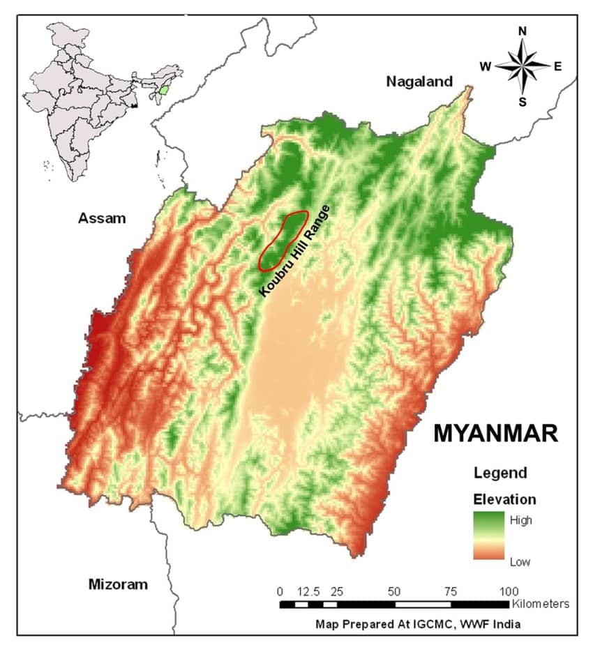
Koubru Hill Range:
- Koubru Hill also known as Mount Koupalu is one of the highest mountains in Manipur, and the abode of the god Lainingthou Koubru and the goddess Kounu in Manipuri mythology.
MIZO HILLS :
- Southernmost part of the Purvanchal, also known as the Lusai Hills
- Lies in Mizoram
- Highest peak – Blue Mountain
- Crossed by the Tropic of Cancer
MANIPUR HILLS :
- Part of the Purvanchal in Manipur
- Loktak Lake is located in it
- Manipur River originates here
- Forms boundary between India and Myanmar
NAGA HILLS :
- Part of the Purvanchal, located between the Patkai Bum and the Manipur Hills in Nagaland
- Highest peak- Saramati (3826m)
- Forms boundary between India and Myanmar
PATKAI BUM :
- Northernmost range of the Purvanchal, located in Arunachal Pradesh
- Forms boundary between India and Myanmar
- Source of Burhi Dihing and Disang rivers
MIKIR :
- Part of the Meghalaya Plateau located in Assam, just south of the Brahmaputra River
- Mikir tribes live here who practise Jhuming cultivation
- Hills consist of the Archaean rocks
RENGMA :
- Part of the Meghalaya Plateau in Assam located to the east of the Mikir Hills
- Full of bamboos and Rengma tribes live here.
DAFLA :
- Part of the Siwalik located in Arunachal Pradesh between the Subansiri River and the Kameng River, that to the south of the Kamla River
- Tribes living here practice Jhuming
- Covered with dense bamboo, pine and deodar trees.
MIRI :
- Part of the Outer Himalayas (Siwalik) in Arunachal Pradesh located between the Subansiri River and the Kameng River that to the north of the Kamla River which separates it forms the Dafla Hills.
- Inhabited by tribes.
- Terraces are built for the cultivation.
ABOR :
- Part of the Siwalik,located in Arunachal Pradesh between the Dibang and the Subansiri river
- Covered with deciduous and evergreen forests
- Inhabited by the tribal peoples
- Highest peak is 3992 m above sea leve
MISHMI :
- Easternmost part of the Siwalik in northeast Arunachal Pradesh from the Dibang River (West) to the Myanmar border in the east
- Dibang River flows through it
NAG PAHAR :
- Located between Pushkar Lake and the city of Ajmer.
- Famous for Panchkund and saint Agastaya’s Cave, and it is believed that Kalidas, the 4th century poet and playright composed Abhigyanam Shakuntalam here itself







Kanchanjungha is the highest mountain in india…but your website shows kanchanjungha is second highest mountain..how is it possible
The highest peak in India – K2
The highest peak in India of Himalaya – Kangchenjunga
Thank you so much Sir ❤️
But at present k2 in POK then how it’s possible to count in india
I’m still confused
In some books K2 in POK and India’s Highest peak kangchenjunga
Officially, POK is part of India, and K2 is officially under the Indian territory that’s why the Highest peak in India – K2.
K2 is highest “peak of India”
Kanchenjunga is highest “peak in India”
k2 is disputed
kanchenjunga is undisputed
K2
k2 or gadvin astien is the highest peak of india
Balaghat Range is in North than Harishchandra Range please correct it !
no that balaghat is of mp maharashtra has balaghat range south to harishchandra
Plz sir upload history notes
I want this in pdf format how to download
beautiful sir
thanku so much
Sir pdf please