

- After Independence India invested heavily in large dams, reservoirs and canal networks. By the early 1970s a policy gap was plain: irrigation potential was being created but not used at the farm level. Water reached the canal, but often not every field, in the right quantity, at the right time and reliably.
- The Command Area Development Programme (CADP) was launched in December 1974 as a centrally sponsored scheme to close this last-mile gap. Its idea: irrigation development does not end with the dam and the canal; it must continue to the farm gate through field channels, drains, land levelling, rotational water supply, crop planning and farmer participation.
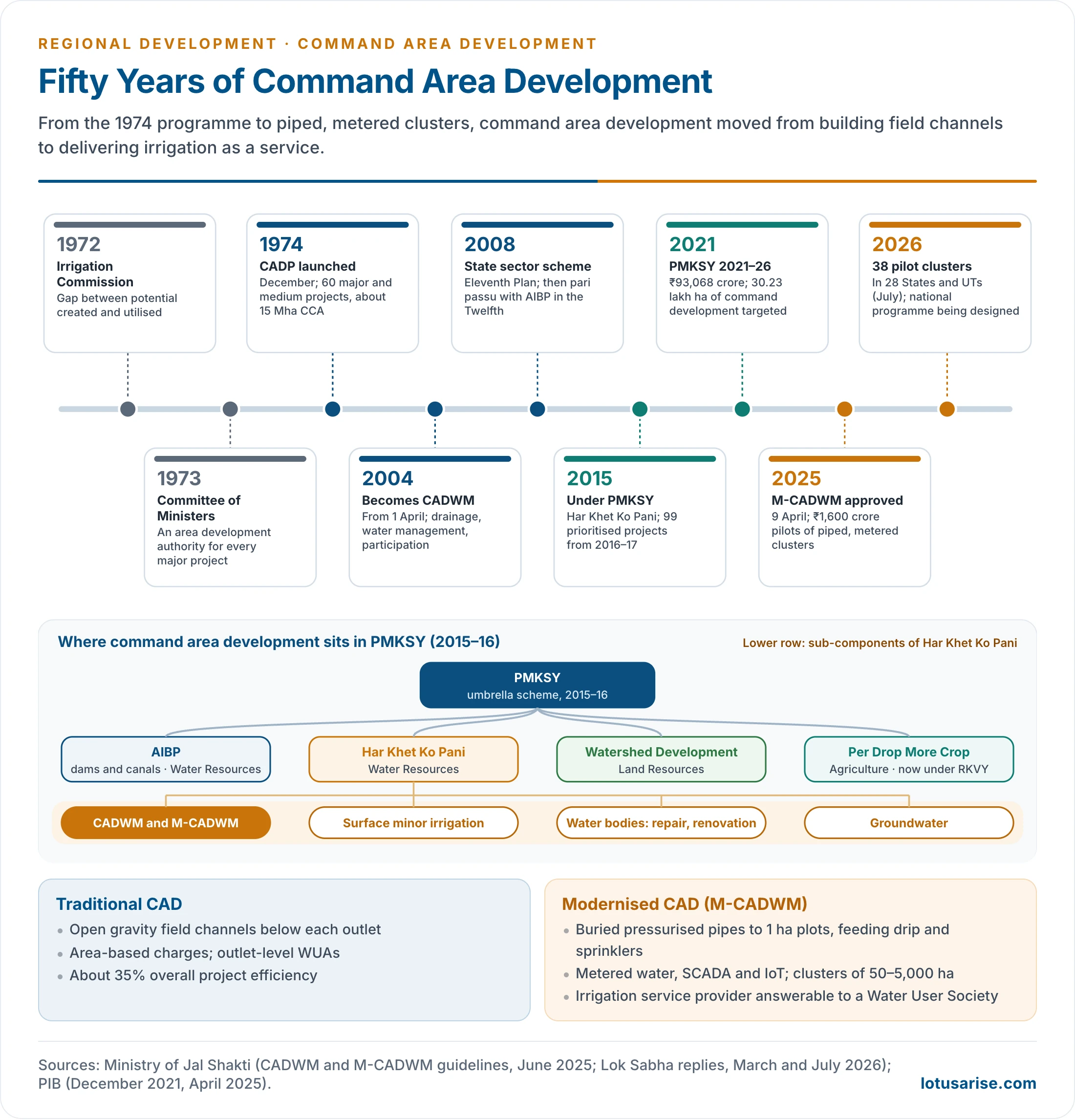
- It was restructured as Command Area Development and Water Management (CADWM) in 2004, brought under the Pradhan Mantri Krishi Sinchayee Yojana (PMKSY) in 2015–16, and modernised as M-CADWM in April 2025.
- It is an integrated area development programme for the command, not merely an engineering scheme. The Indira Gandhi Canal command in western Rajasthan shows both its gains and its ecological costs.
Command Area Development: Concept

Meaning
- A command area is the area that an irrigation project, canal system or other source can irrigate.
- Gross command area (GCA): the whole area that can be served by gravity from the system.
- Culturable command area (CCA): the part of the GCA that can be cultivated, excluding settlements, roads, rock, water bodies and shifting dunes.
- Irrigation potential created (IPC): the area that the completed works can irrigate. Irrigation potential utilised (IPU): the area actually irrigated.
- Command area development is the systematic development of the command so that the potential created by major and medium projects is actually used to raise farm output.
- CAD is the bridge between irrigation infrastructure and agricultural outcome.
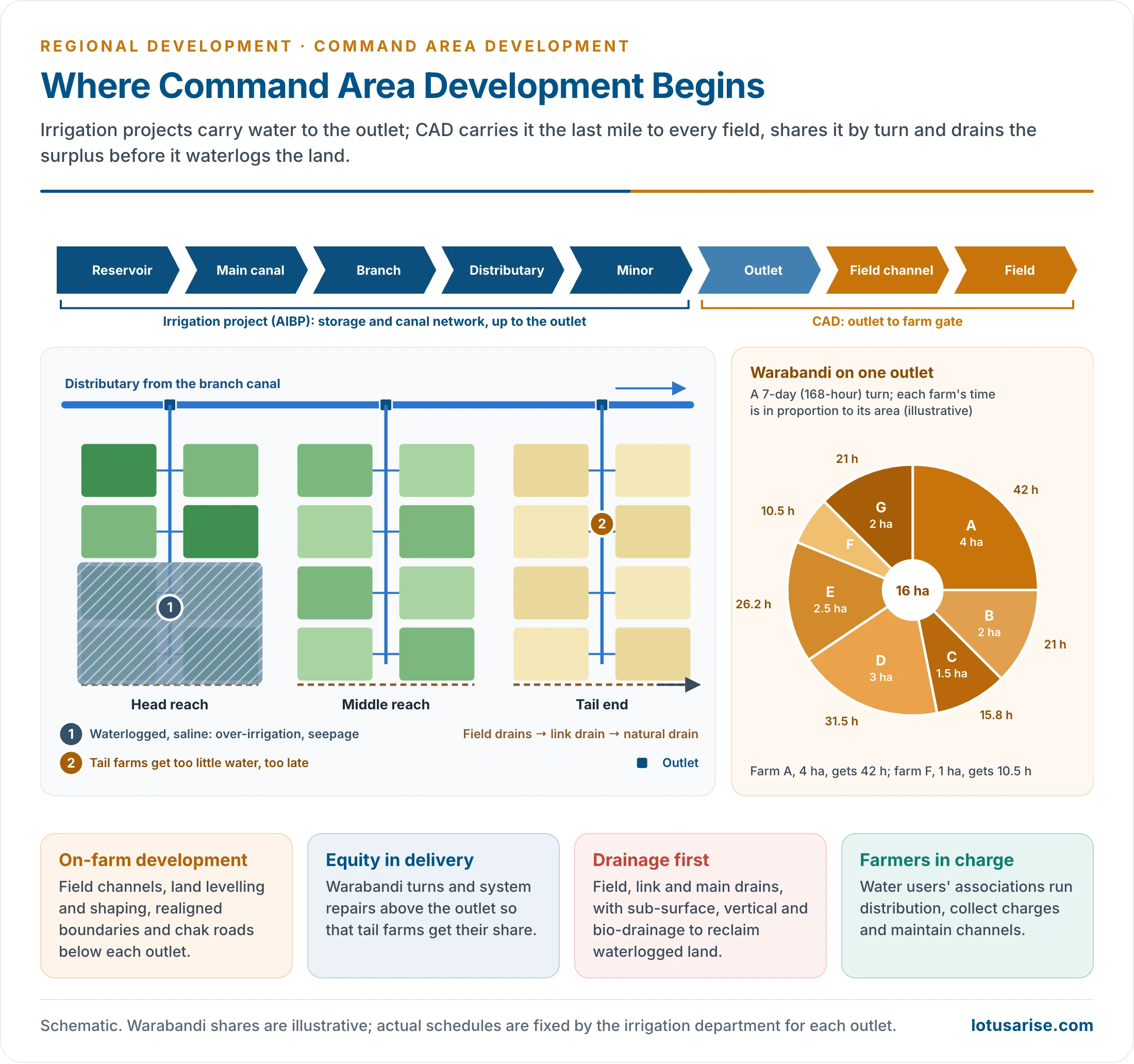
- Dams, storages and main canals are built under irrigation projects (now the Accelerated Irrigation Benefit Programme, AIBP). CAD takes over below the outlet, and corrects system deficiencies above it up to the distributary.
The Utilisation Gap
- The Irrigation Commission (1972) found a growing gap between IPC and IPU and asked that the commands of irrigation projects be developed systematically.
- A Committee of Ministers set up by the Ministry of Irrigation and Power recommended in 1973 a broad-based Area Development Authority for every major project. CADP followed in December 1974.
- Why created potential stays unused:
- No field channels and drains to carry water from the outlet to each holding and to remove the surplus;
- unlevelled, irregular fields, so water spreads unevenly;
- over-irrigation at the head of the canal, causing waterlogging, salinity and alkalinity, and scarcity at the tail;
- cropping not suited to water supply, soil and climate;
- poor maintenance of canals and seepage losses;
- lack of awareness, extension and inputs among farmers;
- unreliable supply at the outlet because of defects in the system upstream.
River Basin and Command Area
- A river basin is a natural, hydrological region: all the land drained by a river and its tributaries, from the water divide to the mouth.
- A command area is an artificial, engineering region: the land a canal system can serve. It often lies outside the basin that supplies its water.
- The Indira Gandhi Canal carries Ravi–Beas water from the Indus basin into the Thar, an area of inland drainage.
- River basin as a planning region:
- Advantages: one unit for water, soil, forest and flood planning; upstream–downstream links are internal; multipurpose development of power, irrigation, navigation and flood control. The Damodar Valley Corporation (1948) applied this, after the Tennessee Valley Authority.
- Disadvantages: basins cut across State boundaries, which causes inter-State disputes (Kaveri, Krishna); they are too large and diverse for detailed planning; and administrative data come by district, not by basin.
| Basis | River basin | Command area |
|---|---|---|
| Nature | Natural, hydrological unit | Artificial, engineering unit |
| Boundary | Water divide | Reach of the canal network |
| Size | Very large (Ganga basin over 8 lakh sq km) | Thousands to lakhs of hectares |
| Planning focus | Multipurpose: water, power, flood, forest, soil | Irrigated agriculture, drainage, water management |
| Main problems | Inter-State sharing, siltation, floods | Head–tail inequity, waterlogging, salinity |
| Indian examples | Damodar, Narmada, Mahanadi | Indira Gandhi Canal, Chambal, Tungabhadra, Nagarjuna Sagar |
| Agency | River boards, DVC, inter-State tribunals | Command Area Development Authorities, water users’ associations |
Catchment and Command in Multipurpose Projects
- A multipurpose project has two development regions: the catchment above the dam, which yields water and silt, and the command below it, which uses the water.
- Catchment problems: deforestation, overgrazing and shifting cultivation speed up soil erosion, so reservoirs silt up faster than designed and lose storage. Floods and landslides damage works, and displaced and tribal people from the submergence zone lose livelihoods.
- A centrally sponsored scheme of soil conservation in the catchments of river valley projects began in 1962, to treat priority sub-watersheds above major reservoirs.
- Command problems: under-use of created potential, head–tail inequity, waterlogging and salinity, and poor drainage.
- Prospects: treat the two as one system.
- Catchment area treatment through watershed management, afforestation and check dams extends reservoir life.
- Command area development turns stored water into crops and incomes.
- Rehabilitation of the displaced and benefit-sharing link the two regions socially.
- The Bhakra–Nangal, Hirakud, Nagarjuna Sagar and Sardar Sarovar projects each pair a Himalayan or plateau catchment with a plains command. Command development was added to each only after its canals were built.
Measuring Command Performance
- Irrigation intensity: gross irrigated area as a percentage of the CCA. Above 100% means more than one irrigated crop a year.
- Utilisation ratio: IPU as a share of IPC; the gap is the target of CAD.
- Water use efficiency: the product of conveyance, distribution and field-application efficiencies.
- Overall efficiency of Indian canal projects is only about 35%. The rest is lost to seepage, evaporation and over-application.
- Equity: water received per hectare at the head, middle and tail of a distributary.
- Water productivity: crop output per cubic metre of water.
- Depth to water table: a water table rising towards the root zone (within about 2 m) signals waterlogging; a falling one signals over-pumping.
Command Area Development Programme (1974)
Launch and Coverage
- CADP began with 60 major and medium irrigation projects covering a CCA of about 15 million hectares. The Indira Gandhi Canal command was among the first.
- In the Fifth Plan, Command Area Development Authorities (CADAs) were set up for these projects, spread over about 110 districts in 13 States. One count gives 38 authorities for 50 projects, serving 12.4 million ha in 108 districts.
- By the end of the Ninth Plan, field channels had been built in about 16 million ha and warabandi enforced in about 11 million ha.
- Coverage later grew to 310 projects with a CCA of about 28.45 million ha (332 projects and nearly 29 million ha on another count).
- Under CADWM there were 145 projects with a CCA of 16.02 million ha.
- About 18.06 million ha had been covered by March 2007, and another 1.62 million ha by March 2011.
- From 2016–17 it was confined to the 99 prioritised AIBP projects, with CAD works in 88 of them.
Objectives
- Bridge the gap between irrigation potential created and utilised through micro-level infrastructure.
- Raise agricultural production and productivity through timely, adequate and equitable water.
- Improve the socio-economic condition of farmers, small and tail-end farmers above all.
- Use water efficiently, protect soil from waterlogging and salinity, and secure participatory irrigation management.
Components
Physical (on-farm development)
- Field channels and field drains: carry water from the outlet to each holding, and drain the surplus. Without them, canal irrigation stays incomplete.
- Land levelling and shaping, realignment of field boundaries and consolidation of holdings with chak roads, so that water spreads evenly.
- Warabandi: a rotational schedule under which each farm on an outlet gets the whole flow for a fixed time, in proportion to its area, on a fixed day of a 7-day cycle.
- It is meant to give equity between head and tail farmers, irrespective of holding size. It is long practised in Punjab, Haryana and Rajasthan.
- Drainage: field, intermediate and link drains to the main drains.
- Reclamation of waterlogged, saline and alkaline land: surface, sub-surface and vertical drainage, and bio-drainage with fast-transpiring trees such as eucalyptus.
- Correction of system deficiencies above the outlet, up to distributaries of specified capacity: desilting, lining, repairs and control structures.
- Conjunctive use of surface water and groundwater, to lower the water table where it is rising and to supplement tail-end supply.
Institutional and agronomic
- Water Users’ Associations (WUAs): farmers plan, distribute water, collect charges and maintain field channels and drains. The National Water Policy 2002 pressed this participatory approach.
- Andhra Pradesh passed the first comprehensive participatory irrigation law, the Farmers’ Management of Irrigation Systems Act, in 1997. It held elections to thousands of WUAs at one stroke.
- Odisha’s Pani Panchayats (Pani Panchayat Act, 2002) and Maharashtra’s Management of Irrigation Systems by Farmers Act (2005) followed.
- In practice many WUAs exist on paper: they lack funds, technical staff and authority over water releases.
- Adaptive trials and demonstrations: border, furrow and check-basin methods, irrigation intervals and crop-water schedules.
- Training and extension for officials and farmers. The Water and Land Management Institutes (WALMIs) in the States build capacity.
- Crop planning suited to the water and soil: oilseeds, pulses and green manure crops beside cereals.
- Inputs and allied activities: seeds, fertiliser, credit, marketing, animal husbandry and forestry. Updating of land records.
Administration and Finance
- Centre: the Ministry of Jal Shakti (Department of Water Resources, River Development and Ganga Rejuvenation) frames policy and funds the scheme. The Central Water Commission monitors projects.
- State: Command Area Development Authorities, multidisciplinary bodies headed by a CAD commissioner or secretary, with engineers, agronomists and soil scientists, implement the works.
- Command and village: WUAs take over operation and maintenance after the works are handed over.
- Funding under CADWM:
- generally 60:40 (Centre:State), and 90:10 for the North-Eastern and Himalayan States and the UTs of Jammu and Kashmir and Ladakh;
- for prioritised projects, 50:50 on structural works such as field channels;
- a larger central share on non-structural work such as training, demonstrations and monitoring: 60:40, and 75:25 for North-Eastern and Himalayan States (75:25 for all States in the 2004 scheme);
- a one-time functional grant to WUAs of about ₹1,000–1,200 per hectare, shared 45:45:10 by Centre, State and farmers;
- central money released in two instalments: 60% on annual targets and a checklist, and 40% once utilisation certificates show that at least half of the first has been spent.
- Since 2016–17 the central share for prioritised projects has also been routed through NABARD’s Long Term Irrigation Fund.
- Monitoring: progress is reported monthly on an online management information system.
- There are three tiers: field checks by CWC CAD Cells, the Project Monitoring Organisation, and a zonal Project Implementation Review Committee. CWC also appraises Detailed Project Reports.
- WUAs get annual third-party audits, and accounts are audited by the Comptroller and Auditor General or the State Auditor General.
Restructuring and Modernisation
From CADP to CADWM under PMKSY
- 1 April 2004: restructured and renamed CADWM, with more weight on water management, drainage, participation and correction of system deficiencies.
- Eleventh Plan (2008–12): run as a State sector scheme. Twelfth Plan: implemented pari passu with AIBP, so that command development kept pace with canal construction.
- 2015–16: placed in the Pradhan Mantri Krishi Sinchayee Yojana under Har Khet Ko Pani. From 2016–17 it was limited to the prioritised AIBP projects.
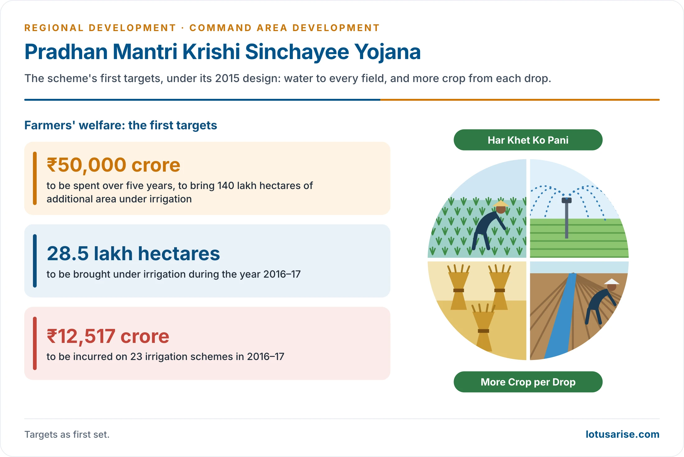
- PMKSY design (2015): motto “Har Khet Ko Pani” (water to every field) and “More Crop per Drop“.
- It joins water sources, distribution networks and farm-level application into one end-to-end chain, planned bottom-up through District Irrigation Plans and State Irrigation Plans.
- It runs in project mode with decentralised State-level planning. The State agriculture department is nodal. A State Level Project Screening Committee scrutinises projects, the State Level Sanctioning Committee under the Rashtriya Krishi Vikas Yojana sanctions them, and an inter-ministerial National Steering Committee reviews them.
- A State qualifies only with District and State Irrigation Plans and a rising trend of irrigation spending in its plan.
- Labour for water works is drawn through convergence with the rural employment programme.
- Need at launch: about 65% of the 142 million ha of farmland lacked irrigation; net irrigated area was about 56.4% of net sown area in 2023–24.
- Funding at launch: 75:25 (Centre:State) and 90:10 for North-Eastern and hilly States; 60:40 and 90:10 now.
- First targets: ₹50,000 crore over five years for 140 lakh ha of new irrigation; 28.5 lakh ha in 2016–17, with ₹12,517 crore for 23 schemes that year.
- It also envisaged interlinking perennial rivers against drought and flood, and stronger Krishi Vigyan Kendras to carry irrigation technology to farmers.
- PMKSY 2021–26 (outlay ₹93,068 crore) targeted 30.23 lakh ha of command area development with the completion of ongoing projects.
- An evaluation by the Planning Commission’s Programme Evaluation Organisation (2015) found that most farming households in sampled commands had benefited. The benefits came through better irrigation, more reliable water, more crops and higher yields.
| PMKSY component (2015–16) | Ministry or department | What it does |
|---|---|---|
| Accelerated Irrigation Benefit Programme | Water Resources (Jal Shakti) | Completes major and medium projects, dams and canals |
| Har Khet Ko Pani: CADWM | Water Resources | Command area development, now with M-CADWM pilots |
| Har Khet Ko Pani: surface minor irrigation, repair and restoration of water bodies, groundwater | Water Resources | New minor irrigation; revival of tanks and ponds |
| Watershed Development Component | Land Resources (Rural Development) | Rainfed and degraded land treatment on a ridge-to-valley plan |
| Per Drop More Crop | Agriculture and Farmers Welfare | Drip and sprinkler subsidy; now run under the Rashtriya Krishi Vikas Yojana |
Modernisation of Command Area Development and Water Management (M-CADWM)
- Approval: the Union Cabinet approved M-CADWM on 9 April 2025 as a sub-scheme of PMKSY for 2025–26, with an initial outlay of ₹1,600 crore (central ₹1,100 crore, States ₹500 crore).
- The shift: called “Irrigation 4.0”, it moves from supply-side engineering to demand-side management.
- Why modernise: gravity flow in open field channels has failed in several ways:
- farmers are reluctant to give land for channels;
- unauthorised withdrawals starve the tail;
- uplands cannot be served;
- channels are poorly maintained;
- surface water cannot feed drip and sprinkler systems, so farmers pump groundwater even inside canal commands.
- Three reforms:
- Infrastructure: underground pressurised piped irrigation from the canal or other source to the farm gate, for plots of about 1 ha. Pipes cut evaporation and percolation losses, typically 20–30%, and serve undulating land without a pump for each farmer. It aims at on-farm water use efficiency of up to 75% with drip and sprinklers, and overall project efficiency rising from about 35% to 50%.
- Water accounting: volumetric measurement by digital meter, water audits, SCADA and Internet of Things sensors for soil moisture, pressure and flow, and daily satellite data on evapotranspiration, so that supply matches the crop’s need.
- Management: the command is divided into clusters of 50 to 5,000 ha. All water sources in a cluster (canal, groundwater, reused water) are managed as one resource.
- Each cluster has a legally registered Water User Society (WUS), to which irrigation management is transferred. It handles local distribution and collects charges.
- Construction contractors become Irrigation Service Providers under contracts of at least five years after construction (“irrigation as a service“), accountable to the WUS.
- Farmer Relationship Agencies give WUSs five years of handholding and link them to FPOs or primary agricultural credit societies.
- Phases of a pilot:
- preparatory: States propose clusters, selected in challenge mode; an executive order demarcates the cluster and farmers form a WUS;
- design: a detailed design report covering technical, social and agro-economic aspects;
- implementation: the piped network is built, in about a year, by the Irrigation Service Provider;
- operation: irrigation management passes to the WUS, with five years of handholding and maintenance support (to March 2031 for the pilots);
- exit: the WUS runs and upgrades the system from its own revenue.
- Governance:
- an Empowered Committee under the Secretary (Water Resources) at the Centre;
- State Level Steering Committees under Chief Secretaries;
- District MCAD Committees under Collectors.
- Funding: 60:40, and 90:10 for the Himalayan and North-Eastern States.
- Expected benefits of the pilot phase: about 150 million cubic metres of water saved, about 80,000 farmers benefiting directly, less pumping energy (about 0.64 million kg of CO2 saved) and a “Make in India” market for irrigation automation.
- Clusters are meant to become agri-growth engines, and modern irrigation to draw young people back to farming.
- Performance-linked incentives reward States and WUSs for early completion and high micro-irrigation use.
- Status (July 2026): 38 pilot clusters in 28 States and UTs sanctioned, among them the Bisalpur Right Main Canal cluster in Rajasthan. ₹550 crore is provided in the 2026–27 budget estimates. A National Programme for the 16th Finance Commission period is being designed from the pilots’ lessons.
| Basis | Traditional CAD and CADWM | M-CADWM (2025) |
|---|---|---|
| Conveyance below outlet | Open, gravity field channels | Underground pressurised pipes to 1 ha plots |
| Water use efficiency | About 35% project efficiency | Up to 75% on farm, 50% overall |
| Water pricing | By area irrigated | Volumetric, metered |
| Unit of management | Outlet-level WUA | Cluster-level Water User Society, 50–5,000 ha |
| Operation and maintenance | Irrigation department, weak WUAs | Irrigation Service Provider accountable to the WUS |
| Water sources | Canal only | Canal, groundwater and reused water integrated |
| Monitoring | Periodic reports | SCADA, IoT, satellite data, online portal |
Indira Gandhi Canal Command Area
The Project
- The Indira Gandhi Nahar Pariyojana (IGNP), formerly the Rajasthan Canal, is one of the largest canal systems in the world. It turns part of the Thar Desert into farmland.
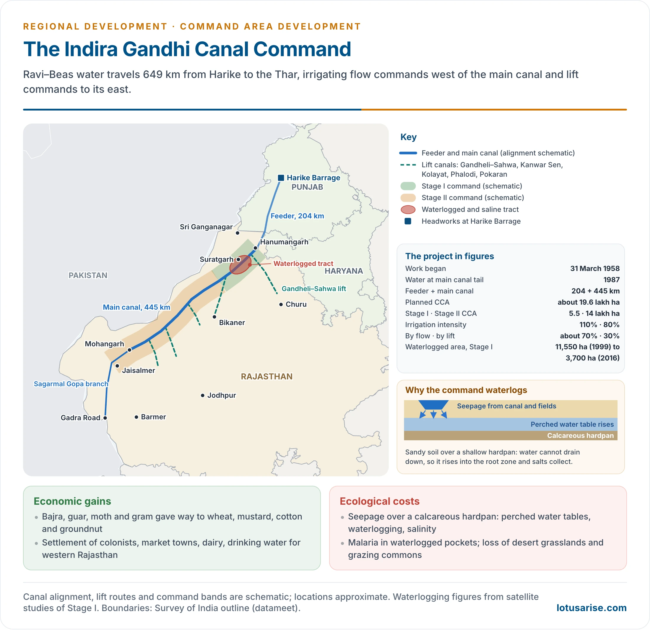
- Work began on 31 March 1958. It takes Ravi–Beas water from the Harike Barrage, below the Satluj–Beas confluence in Punjab.
- The 204 km Indira Gandhi Feeder runs through Punjab and Haryana and irrigates nothing on the way.
- The 445 km Main Canal begins at Masitawali in Hanumangarh district and ends near Mohangarh in Jaisalmer district.
- The Sagarmal Gopa branch carries water towards Gadra Road in Barmer district.
- The main canal is 40 m wide at the bed and 6.4 m deep, carrying 18,500 cusecs at its head.
- Under a proposal of 1981 Rajasthan was allotted 8.6 million acre feet of surplus Ravi–Beas water, of which the project plans to use about 7.6.
- The older reckoning of the command is about 23,725 sq km, a strip about 525 km long and 45 km wide along the border.
- It serves Sri Ganganagar, Hanumangarh, Bikaner, Jaisalmer, Barmer, Jodhpur and Churu districts (several since divided).
- Branches to the west are flow channels, because the land slopes gently towards the border.
- Flow systems include Rawatsar, Suratgarh, Anupgarh, Pugal, Dattor, Barsalpur, Charanwala, Shaheed Birbal and Sagarmal Gopa.
- Most branches to the east are lift schemes: Kanwar Sen (Bikaner), Gandheli–Sahwa (Churu), Gajner, Bangarsar, Kolayat, Phalodi and Pokaran. Rawatsar, taken off near the head of the main canal, is the flow exception on the left bank.
- Two stages:
| Basis | Stage I | Stage II |
|---|---|---|
| Area | Sri Ganganagar, Hanumangarh, north Bikaner | Bikaner, Jaisalmer, Barmer, Jodhpur, Churu |
| Main canal | 189 km (with the 204 km feeder) | 256 km |
| Culturable command area | About 5.5 lakh ha (older plan 5.25: flow 4.79, lift 0.46) | About 14 lakh ha planned (older plan 10.12: flow 7.00, lift 3.12) |
| Terrain | Gently undulating, easier to level | Shifting dunes, higher land needing lift |
| Irrigation intensity planned | 110% (intensive) | 80% (extensive, to spread water and limit waterlogging) |
| Water reached | 1960s | From the mid-1980s; main canal reached its tail in 1987 |
| Distribution system (older plan) | 2,960 km | 4,800 km |
| Irrigation potential (older plan) | 5.78 lakh ha | 8.10 lakh ha |
| Water need (older plan) | 3.59 million acre feet | 4 million acre feet |
| Drinking and industrial use (older plan) | 300 cusecs | 900 cusecs |
| Cost (older plan) | ₹246 crore | ₹1,420 crore |
| Annual food output (older plan) | 14.50 lakh tonnes | 22.50 lakh tonnes |
- The planned CCA is about 19.6 lakh ha (a revised reckoning gives 15.37 lakh ha). About seven-tenths is by flow and three-tenths by lift. The canal also supplies drinking water to towns and villages across western Rajasthan.
CAD in the Indira Gandhi Canal Command
- CAD was introduced in the IGNP command in 1974, with tasks fitted to a newly settled desert:
- Check seepage and pilferage: in sandy soil, conveyance losses below the outlet ran at 30–50%, which wastes water and brings waterlogging and salinity. Lining of the canal and watercourses was essential.
- On-farm development: survey and planning, watercourse lining, land levelling and shaping, and reclamation of degraded land.
- Control of wind erosion: blowing sand silts the canal and distributaries.
- Afforestation and pasture: shelterbelts along the canal, roads and new settlements; sand-dune stabilisation; pasture on culturable waste.
- Migrating dunes damage farmland, pastures and orchards and bury settlements.
- Settlement and amenities: roads, markets, storage, drinking water and civic services for colonists.
- Modern inputs: high-yielding seeds, fertiliser, plant protection, extension and training.
Economic Impact
- Area and intensity: the net sown and double-cropped areas rose sharply. Before irrigation, land was sown only in the kharif and much lay fallow or as culturable waste.
- Cropping pattern: drought-hardy bajra and other millets, guar, moong, moth and gram once occupied about 95% of the cropped area.
- Wheat, mustard, cotton and groundnut now dominate Stage I, on nearly two-thirds of the cropped area, with wheat alone about a quarter. Barley, green manure crops, kinnow orchards, vegetables and fodder join them.
- Yields of cotton, groundnut, paddy and wheat have kept rising. Those of guar, gram and mustard fluctuate, because these crops are not fully irrigated.
- Incomes and settlement: colonisation by landless and small farmers, growing market towns such as Suratgarh, Anupgarh and Rawatsar, dairy and agro-processing.
- Drought-proofing: drinking water and fodder for people and livestock in a famine-prone region, and a buffer against the frequent droughts of the Thar.
Ecological Impact
- Waterlogging and secondary salinity: heavy seepage over a hardpan of calcium carbonate and clay a few metres down produced perched water tables.
- The worst-hit tracts are in Stage I, between the Suratgarh branch and the main canal and in the Ghaggar depression.
- The water table rose by about 0.8 m a year over most of Stage I. About 25% of the command near the Ghaggar basin became critical, with water within 6 m of the surface. Farm and pasture land was left useless in places.
- Satellite studies show the waterlogged area in Stage I falling from about 11,550 ha in 1999 to about 3,700 ha in 2016, after drainage, lining and controlled water allowances. Saline patches persist.
- Health: waterlogged pockets became breeding grounds for mosquitoes, and malaria spread in a region where it had been rare.
- Ecosystem change: loss of desert grasslands and of species of the arid ecosystem; and the spread of Prosopis juliflora and water-loving weeds.
- Social strains: pastoral and nomadic communities lost grazing commons; tail-end and Stage II farmers get unreliable supply; and large holdings captured disproportionate benefits.
- Water insecurity: dependence on Ravi–Beas flows, inter-State sharing disputes and canal closures for repair.
- Remedies:
- extensive irrigation in Stage II, with about 3.66 lakh ha of irrigated pasture proposed for nomadic communities and animal husbandry;
- sprinkler and drip irrigation in sandy soils, now taken further by M-CADWM’s piped clusters;
- vertical and bio-drainage;
- salt-tolerant crops;
- shelterbelts;
- conjunctive use of groundwater;
- warabandi enforcement.
Lessons from the Indira Gandhi Canal
- Water allowance must fit the soil: intensive irrigation on light, permeable sand over a hardpan was a recipe for waterlogging. Stage II’s lower intensity and pressurised application are the corrections.
- Drainage must come with the canal, not decades later.
- Settlement planning matters: allotment of land to the landless, ex-servicemen and displaced families created a new rural society. Amenities, markets and credit lagged behind the water.
- Ecology is part of the command: shelterbelts, dune stabilisation and irrigated pastures for the pastoral economy are as much CAD works as field channels.
- The command depends on the catchment and on inter-State agreements: a desert command fed by Himalayan rivers is only as secure as the Ravi–Beas flows and their sharing.
Evaluation of Command Area Development
Other Major Commands
| Command | States | CAD experience |
|---|---|---|
| Chambal | Rajasthan, Madhya Pradesh | An early CADA (1974); waterlogging and salinity around Kota met by drainage and reclamation |
| Tungabhadra | Karnataka, Andhra Pradesh | Head-reach paddy and sugarcane, tail shortages, waterlogged and saline patches |
| Nagarjuna Sagar | Andhra Pradesh, Telangana | Turned a drought-prone plateau into a rice bowl; inequity between right- and left-bank commands |
| Sharda Sahayak | Uttar Pradesh | Large command on flat terrain; drainage congestion and waterlogging |
| Kosi and Gandak | Bihar | Flood-prone, drainage-congested commands; low utilisation of created potential |
| Sardar Sarovar | Gujarat, Rajasthan | Long canal network to Saurashtra and Kutch; pipelines used for distribution in parts of the command |
Achievements
- Micro-level irrigation infrastructure in millions of hectares: field channels, drains and lined watercourses.
- Warabandi and WUAs spread, and awareness of participatory irrigation management grew.
- Policy moved from building projects to using created potential efficiently: a conceptual shift in Indian irrigation planning.
- Higher cropping intensity and yields in many commands: the Indira Gandhi, Chambal, Tungabhadra and Nagarjuna Sagar commands are among the transformed regions.
Problems and Weaknesses
- Unreliable supply at the outlet: if water does not arrive predictably, field channels and warabandi alone cannot help.
- Narrow focus: in many States CAD shrank to building field channels. Crop diversification, drainage, participation and integrated water management got little attention.
- Weak coordination among irrigation, agriculture, revenue, credit and extension departments. CADAs have little authority over water releases and inputs.
- Poor maintenance of canals and field channels, and weak farmer participation in many projects.
- Head–tail conflict: head-reach farmers grow water-hungry crops; the tail stays short.
- Slow land levelling because holdings are small and fragmented and the work is costly.
- Inadequate drainage, which spreads waterlogging and salinity. Chambal, Tungabhadra, Sharda Sahayak and the north-western canal tracts are well-known examples.
- Weak monitoring: little reliable field data on water use, yields and incomes.
- The challenge is therefore institutional as much as technical.
Waterlogging and Salinity in Canal Commands
- Causes:
- seepage from unlined canals and watercourses;
- over-irrigation at the head;
- flat terrain and blocked natural drainage (roads, railways and canal embankments across drainage lines);
- impervious subsoil layers;
- and the rise of the water table into the root zone, where evaporation leaves salts at the surface.
- Effects: lower yields, abandoned fields, reh and kallar (saline and alkaline crusts) in the north-western plains, damage to buildings and roads, and vector-borne disease.
- Remedies:
- lining and controlled water allowances;
- surface and sub-surface drainage;
- vertical drainage by tube-wells, which also gives conjunctive use;
- bio-drainage plantations;
- gypsum for alkaline soils;
- salt-tolerant crops;
- and a shift to piped and micro-irrigation.
- Scale of reclamation (older count): 579 schemes in nine States (Bihar, Gujarat, Madhya Pradesh, Jammu and Kashmir, Karnataka, Keralam (Kerala), Odisha, Maharashtra, Uttar Pradesh) were approved for 78.81 thousand ha of waterlogged land. About 52.11 thousand ha had been reclaimed.
Command Area Development and Regional Inequality
- Narrowing gaps: CAD extended assured irrigation into arid western Rajasthan and drought-prone tracts of the Deccan, such as the Tungabhadra and Nagarjuna Sagar commands. It raised incomes and stabilised output in regions that had depended on the monsoon.
- Widening gaps: benefits concentrated in canal-irrigated regions, while rainfed uplands and tribal plateaus, outside any command, gained little.
- Within commands, large and head-reach farmers gained more than small and tail-end farmers.
- Waterlogged and saline tracts became new problem areas.
- The net effect is mixed: CAD reduced inter-regional disparity where it reached dry regions, but sharpened the divide between irrigated and rainfed India. Rainfed areas need watershed management and drought-prone area programmes instead.
Need for a Holistic Approach
- Manage irrigation from the headworks to the farm gate as one system. Completing on-farm works should be the start of better water management, not the end of the programme.
- A strong CAD strategy needs:
- assured, measured water delivery;
- functional WUAs and water user societies;
- conjunctive use of surface water and groundwater;
- drainage before waterlogging, not after;
- crop planning matched to water availability;
- volumetric pricing and regular maintenance;
- satellite and sensor-based monitoring;
- convergence with agriculture, credit, markets, micro-irrigation and rural infrastructure.
- Climate change, groundwater depletion and the push for “more crop per drop” make this more urgent. M-CADWM is the attempt to move from canal-command construction to technology-enabled, farmer-managed irrigation service.
Previous Year Questions
2023Critically examine the ecological and economic impact of Indira Gandhi Canal Command Area development.2021Discuss the Command Area Development Programme and its impact on eliminating regional inequalities in India.2014Discuss the concept of Command Area Development and evaluate its success with reference to Indira Gandhi Canal.2008Discuss the problems and prospects of development of catchment and command areas.2003Explain the concept of Command Area development in respect of Multi-Purpose projects of India.1988Differentiate between River Basin and Command Area. Discuss the advantages and disadvantages of River Basins as Planning regions in India. Give concrete examples.





Excellent. Matter provided with powerful insights and knowledge.
Thanks Samvid
You people have put the information So perfectly and simply….to the point and exact! Great 👌