Q. Variations in the length of daytime and nighttime from season to season are due to
(a) The earth’s rotation on its axis
(b) The earth’s revolution round the sun in an elliptical manner
(c) Latitudinal position of the place
(d) Revolution of the earth on a titled axis
Answer: (d) Revolution of the earth on a titled axis
Notes:
- The number of hours of daylight, i.e. day length, on any particular day of the year differs from place to place.
- If we take two locations on the Earth, Earth’s equator and North Pole, then we can find that equator only receives about 12 hours of light each day, whereas the north pole receives 24 hours of daylight for a few months in the summer and then total darkness in the winter months.
- As we know, day and night are the consequence of the earth’s rotation on its axis. But, the axis is tilted 23.5 degrees.
- Due to this reason, during the earth’s revolution around the sun, polar regions spend long periods pointed towards the sun in the summers and long periods pointed away from the sun during winters.
- Days of constant darkness or light occurs at latitudes greater than 66.5 degrees, the regions above the Arctic and the Antarctic.
- The summer solstice or the longest day of the year in the Northern Hemisphere is the day when earth’s north pole is tilting 23.5 degrees towards the sun.
- Similarly, the winter solstice, or the shortest day of the year in the Northern Hemisphere is the day when the earth’s north pole is tilting 23.5 degrees away from the sun and the south pole is tilted towards the sun.
- The spring equinox and the autumn equinox are the only two times of the year when the earth’s axis is neither towards nor away from the sun. This results in equal duration of the day and night.
- Thus, we find that variations in the length of daytime and nighttime from season to season are due to the revolution of the earth on a tilted axis.
Q. On the planet earth, most of the freshwater exists as ice caps and glaciers. Out of the remaining freshwater, the largest proportion:
(a) Is found in atmosphere as moisture and clouds
(b) Is found in freshwater lakes and rivers
(c) Exists as groundwater
(d) Exists as soil moisture
Answer: (c) Exists as groundwater
Notes:
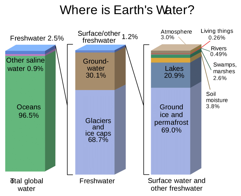
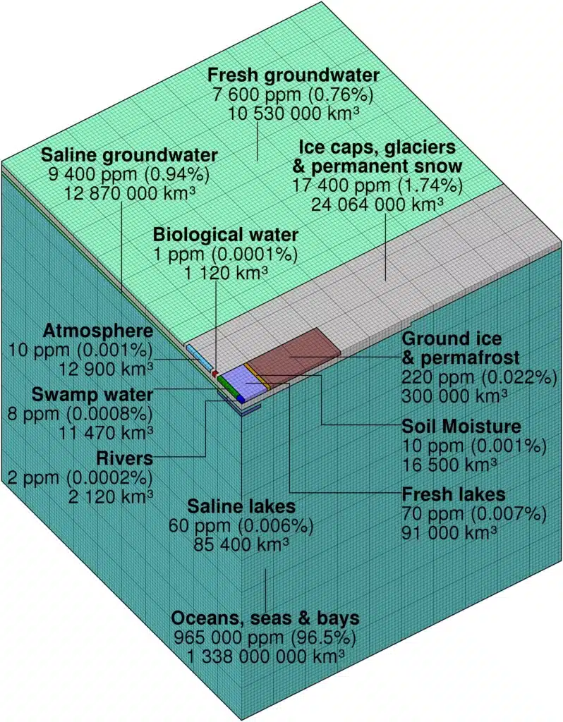
- Out of the total water present on the planet earth, the majority is in the form of seas and oceans (more than 97.5 %) and is termed as a saline water. The remaining water (2.5%) is termed as freshwater. Of the fresh water, only 0.3% is in liquid form on the surface.
- The decreasing order of proportion of freshwater in different forms is as follows:
- snow caps, icebergs, and glaciers > groundwater > freshwater lakes > atmosphere > rivers
| Continent or region | River runoff (km³/year) | Percent of world total |
|---|---|---|
| Asia (excluding Middle East) | 13,300 | 30.6 |
| South America | 12,000 | 27.6 |
| North America | 7,800 | 17.9 |
| Oceania | 6,500 | 14.9 |
| Sub-Saharan Africa | 4,000 | 9.2 |
| Europe | 2,900 | 6.7 |
| Australia | 440 | 1.0 |
| Middle East and North Africa | 140 | 0.3 |
Q. Consider the following
- Electromagnetic radiation
- Geothermal energy
- Gravitational force
- Plate movements
- Rotation of the earth
- Revolution of the earth
Which of the above are responsible for bringing dynamic changes on the surface of the earth?
(a) 1, 2, 3 and 4 only
(b) 1, 3, 5 and 6 only
(c) 2, 4, 5 and 6 only
(d) 1, 2, 3, 4, 5 and 6
Answer: (d) 1, 2, 3, 4, 5 and 6
Notes:
- Electromagnetic Radiation:
- Radiation has both electric and magnetic fields and travels in waves. Electromagnetic radiation can vary in strength from low energy to high energy. It includes radio waves, microwaves, infrared light, visible light, ultraviolet light, x-rays, and gamma rays. Also called EMR.
- Electromagnetic radiation causes temperature change, Evaporation of water results in Precipitation, Formation of Metamorphic Rocks. It means Electromagnetic radiations bring dynamic changes to the surface of Earth.
- Geothermal Energy:
- The energy emanating from within the earth is the main force behind endogenic geomorphic processes.
- This energy is mostly generated by radioactivity, rotational and tidal friction and primordial heat from the origin of the earth.
- This energy due to geothermal gradients and heat flow from within induces diastrophism and volcanism in the lithosphere.
- Due to variations in geothermal gradients and heat flow from within, crustal thickness and strength, the action of endogenic forces are not uniform and hence the tectonically controlled original crustal surface is uneven.
- Gravitational Force:
- Gravity besides being a directional force activating all downslope movements of matter also causes stresses on the earth’s materials.
- eg. Mass movement, Avalanche.
- Plate Movements:
- Plate movement results in continent building, Earthquake.
- Rotation of the Earth:
- Rotation of earth about the axis results in the uneven heating of earth surface causes Pressure difference and forms the Winds.
- Winds are associated with a phenomenon like Rainfall, Heat budget, Ocean currents etc.
- Revolution of the Earth:
- Earth rotates around the sun in an elliptical manner. When the distance between the sun and Earth is Highest is called Aphelion and when the distance is smallest then is called Perihelion, which creates the difference in the intensity of sunlight that reaches Earth.
- Earth is bound by the Gravitational force of the sun causing the Tides in the ocean.
Q. Contour bunding is a method of soil conservation used in
(a) Desert margins, liable to strong wind action
(b) Low flat plains, close to stream courses, liable to flooding
(c) Scrublands, liable to spread of weed growth
(d) None of the above
Answer: (d) None of the above
Contour Bunding
- Contour bunding is a land management practice for marginal, sloping, and hilly land where the soil productivity is very low.
- It involves the placement of lines of stones along the natural rises of a landscape. This technique helps to capture and hold rainfall before it can become runoff.
- It also inhibits wind erosion by keeping the soil heavy and moist.
- This method of soil and water conservation is employed in hilly areas.
- Earthen embankments are built across the slope of the land, following the contour as close as possible.

Some common methods of preventing soil erosion are:
- Shelterbelts – in this, trees and shrubs are planted in the areas liable to strong wind action, to shield the fields against winds.
- Terracing – this is also practiced in the sloppy areas.
- Perimeter runoff control – it helps in preventing soil erosion by impeding surface flows.
- Mixed cropping and crop rotation also help in soil conservation by preventing the nutrients from getting eroded.
Q. The annual range of temperature in the interior of the continents is high as compared to coastal areas. What is/are the reason(s)?
- Thermal difference between land and water
- Variation in altitude between continents and oceans
- Presence of strong winds in the interior
- Heavy rains in the interior as compared to coasts
Select the correct answer using the codes given below.
(a) 1 only
(b) 1 and 2 only
(c) 2 and 3 only
(d) 1, 2, 3 and 4
Answer: (a) 1 only
Notes:
- One major factor affecting the distribution of the temperature of Earth is the distribution of Land and Oceans.
- Since there is more land in Northern Hemisphere and more water in the Southern hemisphere and there is a big difference between the specific heat of land and water; the loss of heat from the continents is bigger than the oceans.
- The continents get heated faster and get cooled faster in comparison to the Oceans.
- This is the reason that the temperatures of the Oceans are moderate while that of continents is extreme.
- The moderating effect on the temperature of the land due to the proximity of the seas is called Maritime influence.
- The increasing effect on the temperature of the land at the interior of the continents is called Continental Influence.
Q. During the thunderstorm, the thunder in the skies is produced by the
- meeting of cumulonimbus clouds in the sky
- lightning that separates the nimbus clouds
- violent upward movement of air and water particles
Select the correct answer using the codes given below.
(a) 1 only
(b) 2 and 3
(c) 1 and 3
(d) None of the above
Answer: (d) None of the above
Notes:
- Lightning is the most spectacular element of a thunderstorm. Lightning is a discharge of electricity. A single stroke of lightning can heat the air around it to 30,000°C (54,000°F). This extreme heating causes the air to expand explosively fast. The expansion creates a shock wave that turns into a booming sound wave, known as thunder.
- Thunderstorms result from the rapid upward movement of warm, and moist air.
- They can occur inside warm, moist air masses and at fronts.
- As the warm, moist air moves upward, it cools, condenses, and forms cumulonimbus clouds that can reach heights of over 20 km (12.45 miles).
- The thunderstorms are associated with the cumulonimbus clouds.
- These clouds normally form on warm sunny days but they can also be found on the cold front.
- From above it is clear that thunder in the sky is not produced by the meeting of cumulonimbus clouds in the sky.
Q. Which of the following statements regarding laterite soils of India are correct?
- They are generally red in colour,
- They are rich in nitrogen and potash.
- They are well-developed in Rajasthan and UP.
- Tapioca and cashew nuts grow well on these soils
Select the correct answer using the codes given below.
(a) 1, 2 and 3
(b) 2, 3 and 4
(c) 1 and 4
(d) 2 and 3 only
Answer: (c) 1 and 4
Lateritic Soils
- Laterite soils are mostly the end products of weathering.
- They are formed under conditions of high temperature and heavy rainfall with alternate wet and dry periods.
- Heavy rainfall promotes leaching (nutrients gets washed away by water) of soil whereby lime and silica are leached away and a soil rich in oxides of iron and aluminium compounds is left behind.
- ‘Laterite’ means brick in Latin. They harden greatly on losing moisture.
- Laterite soils are red in colour due to little clay and more gravel of red sand-stones.
- Chemical composition of Laterite – Lateritic Soils
- Laterite soils are rich in bauxite or ferric oxides.
- They are very poor in lime, magnesia, potash and nitrogen.
- Sometimes, the phosphate content may be high in the form of iron phosphate.
- In wetter places, there may be a higher content of humus.
- Distribution of Laterite – Lateritic Soils
- Laterite soils cover an area of 2.48 lakh sq km.
- A continuous stretch of laterite soil is found on the summits of Western Ghats at 1000 to 1500 m above mean sea level, Eastern Ghats, the Rajmahal Hills, Vindhyan, Satpuras and Malwa Plateau.
- They also occur at lower levels and in valleys in several other parts of the country.
- They are well developed in south Maharashtra, parts of Karnataka etc. and are widely scattered in other regions.
- Crops in Laterite – Lateritic Soils
- Laterite soils lack fertility due to intensive leaching.
- When manured and irrigated, some laterites are suitable for growing plantation crops like tea, coffee, rubber, cinchona, coconut, arecanut, etc.
- In some areas, these soils support grazing grounds and scrub forests.
Red Soils
- Red soils along with their minor groups form the largest soil group of India.
- The main parent rocks are crystalline and metamorphic rocks like acid granites, gneisses and quartzites.
- Characteristics of Red Soils
- The texture of these soils can vary from sand to clay, the majority being loams.
- On the uplands, the red soils are poor, gravelly, and porous. But in the lower areas, they are rich, deep dark and fertile.
Must Read: Soil types in India
Q. Consider the following crops:
- Cotton
- Groundnut
- Rice
- Wheat
Which of these are Kharif crops?
(a) 1 and 4
(b) 2 and 3 only
(c) 1, 2 and 3
(d) 2, 3 and 4
Answer: (c) 1, 2 and 3
Notes:
- Kharif Crops: Paddy, Jowar, Bajra, Maize, Ragi, Arhar(Tur), Moong, Urad, Cotton, Groundnut, Sunflower Seed, Soybean Black, Sesamum, Nigerseed
- Rabi crops: Wheat, Barley, Gram, Masur (Lentil), Rapeseed/Mustard, Safflower, Toria,
- Other Crops: Copra, De-Husked Coconut, Jute, Sugarcane
- Wheat
- Second most important staple food for the Indian population.
- It is a rich source of calcium, thiamine, riboflavin and iron.
- The preferred staple food in northern and north-western parts of the country.
- Climatic conditions for wheat
- Wheat is a temperate crop that requires a cool climate with moderate rainfall.
- It shows great adaptability & can be grown in tropics as well (yields are low in tropics).
- It is a rabi crop (winter crop – requires cool and less moist climate).
- Groundnut
- Groundnut is the most important oilseed in India.
- It accounts for nearly half of the major oilseeds produced in India.
- Groundnut kernels are rich in proteins and vitamins and have high calorific value.
- It contains 40-50% oil which is used as edible oil or hydrogenated vanaspati.
- The oil is used for manufacturing margarine, medical emulsions, soap etc.
- Its oil cake is used as an important rich cattle feed.
Also read: Cropping Patterns in India
Q. With reference to the usefulness of the by-products of sugar industry which of the following statements is/are correct?
- Bagasse can be used as biomass fuel for the generation of energy.
- Molasses can be used as one of the feedstocks for the production of synthetic chemical fertilizers.
- Molasses can be used for the production of ethanol.
Select the correct answer using the codes given below
(a) 1 only
(b) 2 and 3 only
(c) 1 and 3 only
(d) 1, 2 and 3
Answer: (c) 1 and 3 only
Bagasse :
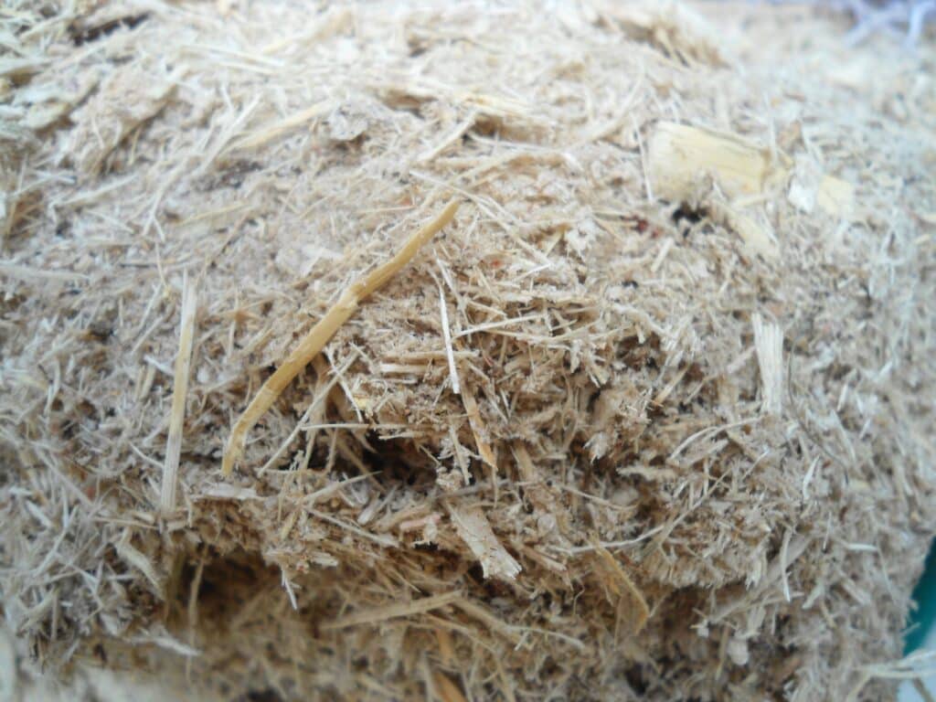
- The remnant left after extracting the juice of the sugarcane or sorghum is known as bagasse. It is a dry pulpy fibrous material.
- The name is derived from the French word ‘bagage’ and the Spanish word ‘bagazo’ which means refuse or trash.
Uses of Bagasse:
- As a Fuel – It is used for the generation of heat energy and electricity. The sugar mills use it as their primary fuel source, as it generates sufficient energy to fully power a sugar mill. Ethanol produced from it is also used as a popular fuel in some countries.
- In the production of Pulp, Paper, and Board – In many countries like India, China, Thailand, etc. it substitutes wood to produce pulp, paper, and board.
- To Feed Cattle – it can be used as cattle feed when mixed with molasses and enzymes and then fermenting.
Molasses :
- It is the thick syrup that results from the refining of sugarcane or sugar beets into sugar.
- it contains a good amount of vitamin B6 and minerals like calcium, magnesium, iron, and manganese.
Uses of Molasses:
- Sugarcane molasses is primarily used to sweeten and flavour foods.
- Molasses is a major constituent of fine commercial brown sugar.
- In baking and cooking
- Producing ethanol and is the prime ingredient in the distillation of rum and brewing beer
- As a cattle feed
Q. Which one among the following industries is the maximum consumer of water in India?
(a) Engineering
(b) Paper and pulp
(c) Textiles
(d) Thermal power
Answer: (d) Thermal power
Notes:
- India is a water rich country with 4% of world’s water resources.
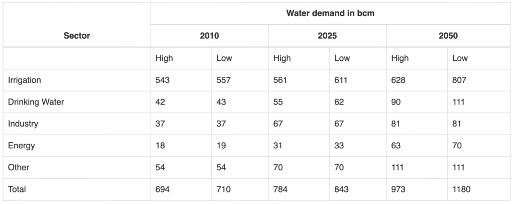
- Of the total water use by the industry, thermal power plants are the biggest users of water and account for 88% of the total industrial water use.
- They are followed by engineering (5.05%) pulp & paper (2.26%) and textiles (2.07%) industries.
- Power Generation Scenario:
- India mainly uses three types of thermal power plants- Coal, Gas and Liquid-fuel based.
- The electricity generated by these plants adds up to 62.2% of the total power generation in the country.
Q. Which of the following is/are the characteristic/characteristics of Indian coal?
- High ash content
- Low sulphur content
- Low ash fusion temperature
Select the correct answer using the codes given below.
(a) 1 and 2 only
(b) 2 only
(c) 1 and 3 only
(d) 1, 2 and 3
Answer: (a) 1 and 2 only
Notes:
- Indian coals by their very nature are high in ash content generally 25 to 45 % whereas average ash content of imported coal varies from 10 to 20 % but low in sulphur content.
- Indian Coal has comparatively higher ash content than imported coal due to drift theory of formation of coal deposits in India. Coal seams formed due to drift theory contains higher ash as compared to in-situ theory of formation.
- Indian coal is its high ash fusion temperature of about 1,500°C.
Classification of Coal
- Coal is originated from organic matter wood. When large tracts of forests are buried under sediments, wood is burnt and decomposed due to heat from below and pressure from above. The phenomenon makes coal but takes centuries to complete.
- Classification of Coal can be done on the basis of carbon content and time period.
- On the basis of carbon content it can be classified into the following three types:
- Anthracite: It is the best quality of coal with the highest calorific value and carries 80 to 95% carbon content.
- It ignites slowly with a blue flame and found in small quantities in Jammu and Kashmir.
- Bituminous: It has a low level of moisture content with 60 to 80% of carbon content and has a high calorific value.
- Jharkhand, West Bengal, Odisha, Chhattisgarh and Madhya Pradesh have deposits of Bituminous.
- Lignite carries 40 to 55% carbon content and is often brown in colour with high moisture content thus, gives smoke when burnt.
- Rajasthan, Lakhimpur (Assam) and Tamil Nadu have deposits of Lignite.
- Peat is the first stage of transformation from wood to coal with low calorific value and less than 40% carbon content.
- Anthracite: It is the best quality of coal with the highest calorific value and carries 80 to 95% carbon content.
Q. Consider the following statements:
- Natural gas occurs in the Gondwana belts.
- Mica occurs in abundance in Kodarma.
- Dharwars are famous for petroleum.
Which of the statements given above is/are correct?
(a) 1 and 2
(b) 2 only
(c) 2 and 3
(d) None
Answer: (b) 2 only
Notes:
- Gondwana is famous for coal fields not for natural gas.
- Dharwar (Karnataka) has other minerals like iron, manganese, not petrol.
- Mica occurs in Kodarma mines in Jharkhand.
Natural Gas
- Distribution: Gulf of Kutch, Gulf of Khambhat, Bassein field, Bombay High, Barmer in Rajasthan, KG basin, Cuddalore district of Tamil Nadu, Odisha, Assam, Tripura, etc.
- India’s economically viable reserve of natural gas is 541 BCM (on-shore, Assam, and Gujarat), besides them 190 BCM offshore in Bay of Cambay and 190 BCM(billion cubic metres) in Bombay High.
- Recently a huge reserve of 400 BCM is reported in Tripura Basin. Besides them, 72 BCM is in the Rava structure and a huge reserve is reported around Andaman and Nicobar island.
- On the basis of remote sensing information, Andaman and Nicobar reserves are estimated to be around 1700 BCM. Its economic viability is yet to be established, that’s why production has not yet started. This reserve will solve the problem or need of India for 100 years. This may produce an economic revolution in eastern India.
Mica
- Mica is a naturally occurring non-metallic mineral that is based on a collection of silicates.
- Mica is a very good insulator that has a wide range of applications in the electrical and electronics industry.
- It can withstand high voltage and has a low power loss factor.
- It is used in toothpaste and cosmetics because of its glittery appearance. It also acts as a mild abrasive in toothpaste.
- India is one of the foremost suppliers of mica to the world.
- Mica-bearing igneous rocks occur in AP, Bihar, Jharkhand, Maharashtra, Rajasthan.
- Mica Reserves in India
- Andhra Pradesh (41 per cent)
- Rajasthan (21 per cent)
- Odisha (20 per cent)
- Maharashtra (15 per cent)
- Bihar (2 per cent)
- Jharkhand (Less than 1 per cent)
- Mica Distribution and Production in India
- India has a near-monopoly in the production of mica [60 % of the world’s total].
- Production decreased in recent times due to the fall in demand in the international market.
- Fall in demand is due to better synthetic alternatives that are available.
Strategic Petroleum Reserve
- Indian Strategic Petroleum Reserves Limited is an Indian company responsible for maintaining the country’s strategic petroleum reserves.
- ISPRL is a wholly owned subsidiary of the Oil Industry Development Board, which functions under the administrative control of the Ministry of Petroleum and Natural Gas.
- Strategic crude oil storages are at three underground locations in Mangalore, Visakhapatnam and Padur (Udupi, Karnataka), Chandikhole, Odisha.
Also Read:
Q. Consider the following pairs:
National Park through the park River Flowing
- Corbett National Park : Ganga
- Kaziranga National Park : Manas
- Silent Valley National Park : Kaveri
Which of the above pairs is/are correctly matched?
(a) 1 and 2
(b) 3 only
(c) 1 and 3
(d) None
Answer: (d) None
Notes:
- Rivers in Jim Corbett National Park
- The Ramganga river (Ramganga is a tributary of Ganga) along with its significant tributaries Sonanadi, Palain, and Mandal forms the prominent hydrological resource for the Corbett.
- The river Kosi also flows by national park and serves as a significant water resource for the nearby area.
- Kaziranga is a vast stretch of tall elephant grass, marshland and dense tropical moist broadleaf forests crisscrossed by four main rivers – Brahmaputra, Diphlu, Mora Diphlu, and Mora Dhansiri and has numerous small water bodies.
- Silent Valley National Park
- The River Kunthi descending from the Niligiri hills above from an altitude of 2000 m flows about 25 km through the valley.
- Locally known as Kunthi puzha (puzha in Malayalam means river) the river never turns brown; it is crystal clear, perennial and wild.
| National Park | River flowing through the Park |
|---|---|
| Corbett National Park | Ramganga |
| Kaziranga National Park | Brahmaputra, Diphlu, Mora Diphlu and Mora Dhansiri |
| Silent Valley National Park | Kunthipuzha |
Must Read:
Q. The Narmada river flows to the west, while most other large peninsular rivers flow to the east. Why?
- It occupies a linear rift valley.
- It flows between the Vindhyas and the Satpuras.
- The land slopes to the west from Central India
Select the correct answer using the code given below.
(a) 1 only
(b) 2 and 3
(c) 1 and 3
(d) None
Answer: (a) 1 only
Narmada
- The river Narmada originates on the western flank of the Amarkantak plateau at a height of about 1,057m.
- Unlike most of the peninsular rivers, Narmada and Tapi rivers flow to the west.
- Also unlike most of the peninsular rivers, Narmada is a perennial river and meanders through the rich plain of Bharuch district of Gujarat.
- The river Narmada and Tapi flow through the rift valley, caused due to upheaval of the Himalayas, between the Satpura in the south and the Vindhyan range in the north. Flowing in the rift valley it forms a picturesque gorge in marble rocks and Dhuandhar waterfall near Jabalpur.
- Statement 2 is factually correct however, is not the reason for the rivers to flow to the west.
- The river covers a distance of approx. 1,312 km before it meets the Arabian Sea south of Bharuch, forming a broad 27km long estuary.
- Sardar Sarovar Dam is built on the river Narmada.
- The river is known as the ‘Lifeline of Madhya Pradesh and Gujarat‘.
- The Peninsular Drainage System is older than the Himalayan Drainage System.
- The rivers like Chambal, Sind, Betwa, Ken, Son originate in the northern part of the peninsula and belong to the Ganga river system.
- Other prominent rivers of the peninsular region are – Mahanadi, Godavari, Krishna, and Kaveri.
- Common characteristics of peninsular rivers include – fixed course, absence of meanders, and non-perennial flow.
Q. Consider the following pairs:
- Nokrek Biosphere reserve : Garo Hills
- (Loktak) Lake : Barail Range
- Namdapha National Park : Dafla Hill
Which of the above pairs is/are correctly matched?
(a) 1 only
(b) 2 and 3 only
(c) 1, 2 and 3
(d) None
Answer: (a) 1 only
Nokrek Biosphere Reserve:
- It is located in the Garo Hills district of Meghalaya.
- The biosphere reserve derives its name from the Nokrek Hill, the highest peak of the Garo Hills.
- The Nokrek National Park was added to the list of biosphere reserves by UNESCO in May 2009.
Loktak Lake:
- It is a freshwater lake located in Manipur and is famous for the phumdis floating over it.
- Keibul Lamjao National Park, the only floating national park in the world is situated on this lake.
- The lake is divided into three zones – northern, central, and southern zones.
Namdapha National Park:
- It is located in the Changlang district of Arunachal Pradesh and finds a place between the Dapha bum range and the Patkai range.
- Noa Dihing River crosses the national park from east to west.
- It houses the world’s northernmost lowland evergreen rainforests, dipterocarp forests.
Garo Hills:
- These are part of the Garo-Khasi range and are located in Meghalaya.
- The Garo-Khasi range is part of the Meghalaya subtropical ecoregion and is one of the wettest places in the world.
- Tura town located at the foothills of Tura peak is the largest town in the Garo Hills.
- Nokrek National Park and the Balphakram National Park are also located here.
Barail Range:
- It is a tertiary mountain range located in the Dima Hasao district of Assam, between the Brahmaputra and Barak basins.
- It has Meghalaya on the west and Nagaland and Manipur on the east.
Dafla Hills:
- It is located in Arunachal Pradesh and is bounded by the Abor range in the east and Aka hills on the west.
- It is inhabited by the Dafla tribe.
Q. Which one of the following pairs is correctly matched?
Geographical Region Feature
(a) Abyssinian Plateau : Arabia
(b) Atlas Mountains : NorthWestern Africa
(c) Guiana Highlands : SouthWestern Africa
(d) Okavango Basin : Patagonia
Answer: (b) Atlas Mountains : NorthWestern Africa
Abyssinian Plateau
- Abyssinian Plateau is situated in Ethiopia (Africa).
- It is also known by other names like Altipiano Etiopico, Amhara Plateau, Ethiopian Massif, and Ethiopian Plateau.
- Ethiopia was once called Abyssinia, hence the name Abyssinian Plateau.
- The plateau is 1290-3000 m above sea level.
- A number of rivers cross the plateau, the most prominent being the Blue Nile, rising from Lake Tana.
Atlas Mountains
- The Atlas Mountains are a mountain range located in the Maghreb, also known as Northwest Africa, the Greater Maghreb, and historically as the Barbary Coast.
- The Mediterranean and Atlantic coastlines get separated from the Sahara Desert by the Atlas Mountains.
- Toubkal (4167 m) is the highest peak of this mountain range and is situated in Morocco. Apart from Morocco, the mountains are located in Algeria and Tunisia.
- Berber populations are native to the Atlas Mountains.
Guiana Highlands
- The Guiana Highlands are located to the north of Amazon and to the south of the Orinoco River, in South America.
- The Guiana Highlands cover parts of Venezuela, Guianas, Brazil, and Colombia.
- The eastern part of the Amazon lowland separates the Brazilian and Guiana Highlands.
- The highlands comprise a basement of rolling hilly mountains, low mountains, and tabular plateaus.
- The highest elevation of the Guiana Highlands is Mount Roraima (2772 m).
Okavango Basin
- The Okavango Basin covers the portions of the following Southwestern African countries: Angola, Botswana, Namibia, and Zimbabwe.
- The basin derives its name from the chief stream in the basin, the Okavango River. The Okavango river forms the Okavango delta in Botswana.
- The basin is formed by the confluence of the Cuito and Cubango rivers.
- The Nwako salt pan lies to the south of the basin and the Makdadikgadi salt pan lies to the southeast of the basin.
Q. The most important fishing grounds of the world are found in the regions where
(a) warm and cold atmospheric currents meet
(b) rivers drain out large amounts of fresh water into the sea
(c) warm and cold oceanic currents meet
(d) continental shelf is undulating
Answer: (c) warm and cold oceanic currents meet
Notes:
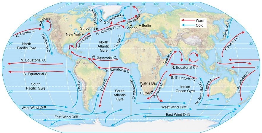
- The most important fishing grounds in the world are located in shallow water close to the land where there is the mixing of cold and warm currents from different regions.
- The major fishing grounds on earth comprise
- the seas north of Japan where the warm Kuroshio Current meets the cold Kamchatka Current;
- the Grand Banks off Newfoundland where the North Atlantic Drift encounters the cold Labrador Current; and
- the sea around Iceland where the North Atlantic Drift meets the East Greenland Current.
Q. Which of the following is/are unique characteristic/characteristics of equatorial forests?
- Presence of tall, closely set trees with crowns forming a continuous canopy
- Coexistence of a large number of species
- Presence of numerous varieties of epiphytes
Select the correct answer using the code given below:
(a) 1 only
(b) 2 and 3 only
(c) 1 and 3 only
(d) 1, 2 and 3
Answer: (d) 1, 2 and 3
Equatorial Rainforest Climate
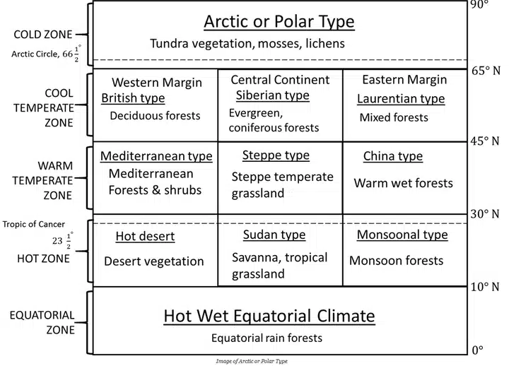
- Equatorial Rainforest Climate is distributed in and around the equator in both hemispheres, as its name suggests.
- The equatorial zone lies between 0 and 10 degrees latitude on either side of the equator.
- It runs from Sumatra to New Guinea in Asia, spanning the Amazon lowlands in South America, the Congo basin in Africa, and the East Indies.
- This region, in other words, covers the continents of South America, Africa, and Asia.
- Equatorial Rainforest Climate is also called the tropical rainforest climate or equatorial climate.
- Features of rainforests are basically the following:
- high animal and vegetal biodiversity
- evergreen trees
- Presence of tall, closely set trees with crowns forming a continuous canopy
- dark and sparse undergrowth interspersed with clearings
- scanty litter (organic matter settling on the ground)
- Presence of numerous varieties of epiphytes
- presence of “strangler” creepers (e.g. Ficus spp.)
- presence of “buttresses” (i.e. large winged ribs at the base of trunks) and spindly roots in trees living in often-flooded areas.
- The area is thought to be a genetic hotspot for a variety of animals.
- Climatic Conditions:
- With an average daily temperature of 28°C, this climate is extremely hot.
- The temperature rarely falls below 20°C and never rises over 35°C.
- The region’s mornings are bright and sunny. In the afternoons, strong convectional rainfall occurs due to the high quantity of evaporation in the region.
- As a result, the region experiences a lot of rain. The yearly rainfall might be as high as 2500mm.
- The temperature is high and the humidity is high.
- The weather is almost constant throughout the year. There are no distinct seasons found here.
- Soil:
- The majority of the soil is deficient in nutrients.
- At the surface, a thin layer of fertile soil forms as the dead leaves decay.
- It is reddish in colour due to its high iron content.
- Nutrients are quickly flushed out of the soil due to excessive rains.
- Wildlife:
- The equatorial region is not only a home to lush and diversified plants but also a shelter to a wide range of wildlife as well.
- Many different animals, birds, and insects are supported by the diverse plant species.
- This region’s fauna include the African elephant and the Jaguar.
- Mountain gorillas, lowland gorillas, chimps, and many bird species all call the Congo basin home.
- Other animals include the poison dart frog, margay, and collared anteater, sloths, toucans, spider monkeys and flying frogs.
Tropical Wet Climate (Af)
- Also known as ‘The Hot, Wet Equatorial Climate’, ‘Equatorial Rainforest Climate’.
- The regions are generally referred to as ‘Equatorial Rainforests’, ‘Equatorial Evergreen Forests’, ‘Tropical Moist Broadleaf Forest’, ‘Lowland Equatorial Evergreen Rainforest’.
- Distribution
- Mostly between 5° N and S of Equator. [little or no Coriolis Force = no tropical cyclones]
- Its greatest extent is found in the lowlands of the Amazon, the Congo, Malaysia, and the East Indies.
Q. “Climate is extreme, rainfall is scanty and the people used to be nomadic herders.”
The above statement best describes which of the following regions?
(a) African Savannah
(b) Central Asian Steppe
(c) North American Prairie
(d) Siberian Tundra
Answer: (b) Central Asian Steppe
Notes:
- Nomadic herding or pastoral nomadism is a primitive subsistence activity, in which the herders rely on animals for food, clothing, shelter, tools and transport.
- They move from one place to another along with their livestock, depending on the amount and quality of pastures and water, thus there is an irregular pattern of movement.
Steppe (Temperate Grassland Climate)
- Climate
- Climate is continental with extremes of temperature.
- Temperatures vary greatly between summer and winter.
- The summers are hot and the winters are cold.
- Summers are very warm, over 18 – 20° C.
- The steppe type of climate in the southern hemisphere is never severe.
- Rainfall
- The average rainfall may be taken as about 45 cm, but this varies according to location from 25 cm to 75 cm.
- The heaviest rain comes in June and July (late spring and early summer).
- Most of the winter months have about an 2.5 cm of precipitation, brought by the occasional depressions of the Westerlies and coming in the form of snow.
- The maritime influence in the southern hemisphere causes more rainfall.
- Grasses
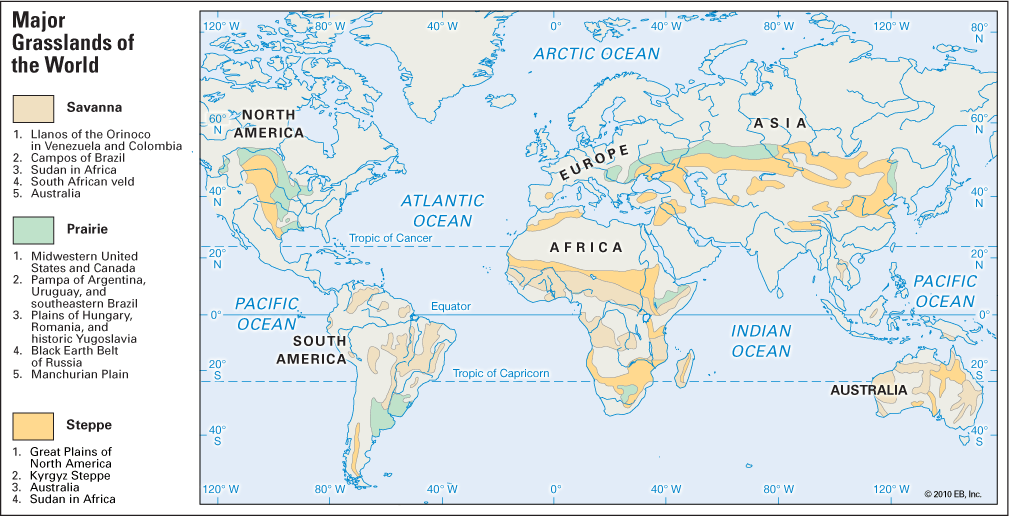
- Greatest difference from the tropical savanna is that steppes are practically treeless and the grasses are much shorter.
- Grasses are tall, fresh and nutritious. This is typical of the grass of the wheat-lands in North America, the rich black earth or chernozem areas of Russian Ukraine and the better watered areas of the Asiatic Steppes.
- Where the rainfall is light or unreliable, or the soil is poor, as in the continental interiors of Asia the short steppe type of grass prevails.
- The grasses are not only shorter but also wiry [lean, tough] and sparse [thinly dispersed or scattered].
- These areas are less suitable for arable farming and are used for some form of ranching as in the High Plains of U.S.A.
- The growth of grasses is not abruptly checked by summer droughts or winter cold.
- Trees
- Polewards, an increase in precipitation gives rise to a transitional zone of wooded steppes where some conifers gradually appear.
- In the cultivated regions, such as the wheat farms of the Prairies, double rows of trees are planted around the house to shield the occupants from the strong wind.
- Animals
- Does not have much animal diversity.
- Horses are common in Asian Steppes.
African Savanna
- The belt includes West African Sudan and then curves southwards into East Africa and southern Africa north of the Tropic of Capricorn.
South American Savanna
- There are two distinct regions namely the llanos of the Orinoco basin [north of equator] and the compos of the Brazilian Highlands [South of equator].
Australian savanna
- The Australian savanna is located south of the monsoon strip (northern Australia) running from west to east north of the Tropic of Capricorn.
Indian Savanna
- Certain parts across Northern Karnataka, Southern Maharashtra and Telangana exhibit characteristics of both semi-arid and savanna climate.
- Due to irrigation and cultivation, this region is different from other savanna regions.
Q. Consider the following pairs:
Tribe State
- Limboo (Limbu) : Sikkim
- Karbi : Himachal Pradesh
- Dongaria : Odisha
- Bonda : Tamil Nadu
Which of the above pairs are correctly matched?
(a) 1 and 3 only
(b) 2 and 4 only
(c) 1, 3 and 4 only
(d) 1, 2, 3 and 4
Answer: (a) 1 and 3 only
Notes:
- Dongaria – Odisha is easy as dongaria kondh tribe was in news due to the POSCO project
- Karbi would be of Assam – karbi aunglong protest for separate state
- Bonda is the most primitive tribal groups in Odisha.
- Tamang and the Limbu communities of Sikkim have been placed in the ST category.
- Tharu Tribals
- The community belongs to the Terai lowlands, amid the Shivaliks of the lower Himalayas. Most of them are forest dwellers and some practised agriculture.
- The word Tharu is believed to be derived from their, meaning followers of Theravada Buddhism.
- The Tharus live in both India and Nepal. In the Indian Terai, they live mostly in Uttarakhand, Uttar Pradesh, and Bihar.
- According to the 2011 census, the Scheduled Tribe population in Uttar Pradesh was more than 11 lakh; this number is estimated to have crossed 20 lakh now.
- The biggest chunk of this tribal population is made up of Tharus.
- Members of the tribe survive on wheat, corn and vegetables are grown close to their homes. A majority still lives off the forest.
- PVTGs in Andaman
- Great Andamanese is one of five PVTGs that reside in the Andamans archipelago.
- The Great Andamanese speak Jeru dialect among themselves and their number stands at 51 as per the last study carried out by Andaman Adim Janjati Vikas Samiti in 2012.
- The five PVTGS residing in Andamans are Great Andamanese, Jarawas, Onges, Shompens and North Sentinelese.
| State | Tribes |
|---|---|
| Andhra Pradesh | Andh, Sadhu Andh, Bhil, Bhaghata, Dhulia,rona, Kolam, Gond, Thoti, Goundu, Kammara, Savaras, Dabba Yerukula, Sugalis, Nakkala, Pardhan, Gadabas, Chenchus A.k.a Chenchawar, Kattunayakan, Jatapus, Manna Dhora |
| Arunachal Pradesh | Singpho, Monpa, Abor, Sherdukpen, Galo, Apatanis |
| Assam | Khasis, Chakma, Dimasa, Gangte, Garos, Hajong, Chutiya |
| Bihar | Gond, Birjia, Asur, Savar, Parhaiya, Chero, Birhor, Santhals, Baiga |
| Chhattisgarh | Nagasia, Biar, Khond, Agariya, Bhattra, Mawasi, Bhaina, |
| Goa | Varli, Dubia, Siddi, Dhodia, Naikda |
| Gujarat | Patelia, Bhil, Dhodia, Bamcha, Barda, Paradhi, Charan, Gamta |
| Himachal Pradesh | Swangal, Gujjars, Lahaulas, Khas, Pangwala, Lamba, Gaddis |
| Jammu and Kashmir | Balti, Garra, Sippi, Bakarwal, Mon, Gaddi, Purigpa, Beda |
| Jharkhand | Gonds, Birhors, Savar, Mundas, Santhals, Khaira, Bhumji |
| Karnataka | Gond, Patelia, Barda, Yerava, Bhil, Koraga, Adiyan, Iruliga, |
| Kerala | Malai, Aarayan, Arandan, Uralis, Kurumbas, Arandan, Eranvallan |
| Madhya Pradesh | Kharia, Bhils, Murias, Birhors, Baigas, Katkari, Kol, Bharia, Khond, Gonds, |
| Maharashtra | Warlis, Khond, Bhaina, Katkari, Bhunjia, Rathawa, Dhodia. |
| Manipur | Thadou, Aimol, Maram, Paite, Chiru, Purum, Kuki, Monsang, Angami |
| Meghalaya | Pawai, Chakma, Raba, Hajong, Lakher, Garos, Jaintias Khasis |
| Mizoram | Dimasa, Raba, Chakma, Lakher, Khasi, Synteng, Kuki, Pawai. |
| Nagaland | Nagas, Angami, Sema, Garo, Kuki, Kachari, Mikir, Konyak, Lotha |
| Odisha | Gadaba, Ghara, Kharia, Khond, Matya, Oraons, Rajuar, Santhals. |
| Rajasthan | Bhils, Damaria, Dhanka, Meenas(Minas), Patelia, Sahariya, Lambada(Banjara). |
| Sikkim | Bhutia, Khas, Lepchas. |
| Tamil Nadu | Adiyan, Aranadan, Eravallan, Irular, Kadar, Kanikar, Kotas, Todas. |
| Telangana | Chenchus. |
| Tripura | Bhil, Bhutia, Chaimal, Chakma, Halam, Khasia, Lushai, Mizel, Namte. |
| Uttarakhand | Bhotia, Buksa, Jaunsari, Raji, Tharu. |
| Uttar Pradesh | Bhotia, Buksa, Jaunsari, Kol, Raji, Tharu. |
| West Bengal | Asur, Khond, Hajong, Ho, Parhaiya, Rabha, Santhals, Savar. |
| Andaman and Nicobar | Great Andamanese, Oraons, Onges, Sentinelese, Shompens. |
| Little Andaman | Jarawa |
| Lakshadweep | Aminidivis, Koyas, Malmis, Melacheris. |
| North-East | Abhors, Chang, Galaong, Mishimi, Singpho, Wancho. |
